• About The Project
  • Palestine in Century
  • Selected Maps
  • Glossary
  • About ARIJ
  • About LRC
  • By Year
    • Case Studies By Year
    • Daily Report By Year
Friday, May 9, 2025
POICA
No Result
View All Result
  • Home
  • Settlements
    • New Israeli Settlements
    • Settlement Expansion
  • Israeli Violations
    • Agriculture
    • Confiscation
    • Demolition
    • Environment
    • Eviction of Palestinians
    • Settlers Attacks
  • Bypass Roads
  • Israeli Plans
  • Segregation
    • Checkpoints
    • Closure
    • Separation Plans
  • Military Orders
  • Reports
    • Daily Report
    • Monthly Report
    • Quarterly Report
No Result
View All Result
POICA
No Result
View All Result

Israel keeps on a 506 dunums land grab in Ramallah governorate

October 21, 2017
in Military Orders
Israel keeps on a 506 dunums land grab in Ramallah governorate


  • Violation: land grab order
  • Location:  Ramallah villages
  • Date of order: June 13, 2017
  • Perpetrators: Israeli Occupation Forces
  • Victims: farmers of the villages

Details:

 The Israeli occupation government issued the military order number (06/88/T) that stated the extension of a land grab order's validity. The order targets 321.3 dunums from the lands of Beituniya city and Ein Arik and Biet Ur Al-Fuqa villages in Ramallah governorate; it intends to create a buffer zone  along the bypass road number 443 that penetrates the area and isolates the western villages of Ramallah from each other.

It should be noted that the order was issued in June 2016 but the affected people only knew about it in February 2017 when they found it thrown away in the targeted lands that are confiscated since 2006. Noteworthy, the validity of the order was extended until the end of 2019. The below table shows details of the land grab order:

City\village

No. of natural block

No. of parcels

Beit Ur Al-Fauqa

2

1-11 ،  18، 24،25،27،28،30،36، 34- 38.

3

7،11،12،14،16- 19.

Beituniya

12

42،43،76

13

19- 22، 24-26، 53،56-60، 82،86، 87

33

12،5،8،10،14-17، 19

35

73،77،78

Ein Arik

6

16- 19، 21، 23

7

27- 31، 33،36

8

38،40،41

9

11، 13-15


It is reported that the aforementioned order came in time with the land grab order number (3/12/T), which targeted 275.5 dunums from Beituniya city, west Ramallah.  The order intends to create a buffer zone  along the bypass road number 443 that links Jerusalem city to Al-Ramlah city in the occupied territories.

It should also be noted that the targeted lands are confiscated since 2003 on the claim of "security purposes". Ever since that time, the order has been extended many time, the latest of which was until 2019.


Photos 1-2: the military order number(3/12/ت)

Photo 3: an aerial photo illustrating the targeted location

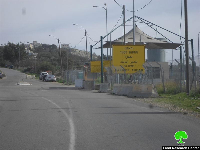
Photos 4-5: the checkpoints set up along the bypass road no. 443


The below table shows details of the land grab order:

No. of natural block

No. of parcels

1

1،15

12

93،94،96،98،99،101

17

212،215،218،219،233،235

18

68-70،74-76، 80-82،87،89،106،107،109

19

7،18،20،21،43،44، 46،47،65،66،94،95

32

60،61،77،79،81،83،85،90،92،97

34

35،44،45،49، 52-55،59.

35

11،26،117،121-124

36

0،114،120-121،122-124،129،130،132،88-91،94،116،117،103-108


Since 2000,the Israeli occupation has been imposing a closure on the 443. Palestinian are not allowed on the road under whatsoever reasons despite it runs through nine Palestinian villages and separates them from each other.


Photos 6-9: the military order number(06/88/ت)

Photo 10: aerial photo illustrating the targeted location

About Beituniya:

3km to the west of Ramallah, Beituniya is edged by Ein Kenya from the north, Ein Arik and Beit Ur from the west, Rafat from the east and Beit Duqo and Al-Jeeb from the south. With a total area of 21165 dunums, of which 3081 dunums are the city's built-up area, Beituniya accommodates 25482 people (2014). The Israeli occupation confiscated an area of 3385 dunums from the city detailed as follows:

1. Israeli colonies confiscated an area of 778 dunums as follows:

Colony

Year of establishment

Confiscated dunums

Population

Beit Horon

1977

222

822

Beit Horon B

1977

109

—

Givat Ze'ev

1982

447

10,790

Total

778

11,612


2. the bypass road number 443 confiscated 687 dunums form the city

3. the apartheid wall looted 1261 dunums for its route and isolated 12655 dunums behind its construction

4.  656 dunums are taken for an Israeli military camp

According to Oslo Accords, the lands of Beituniya are classified as follows:

  • 3797 dunums are classified as area A
  • 470 dunums are classified as area B
  • 16897 dunums are classified as area C

Some International conventions and Humanitarian laws pertaining to attacks on land and natural resources are:

 Article 17 of the Universal Declaration of Human Rights states:

  • Everyone has the right to own property alone as well as in association with others.
  • No one shall be arbitrarily deprived of his property.

Article 1 of the International Covenant on Civil and Political Rights States:

"All peoples may, for their own ends, freely dispose of their natural wealth and resources without prejudice to any obligations arising out of international economic co-operation, based upon the principle of mutual benefit, and international law. In no case may a people be deprived of its own means of subsistence."


Prepared by
 The Land Research Center
LRC
 

Recommended For You

الأراضي الفلسطينية بين الذرائع الأمنية والأطماع الاستيطانية – “الأمن، الآثار، والطبيعة كحجج لاقتلاع الفلسطينيين من أراضيهم”

by arij
April 15, 2025
0

مقدمة شهدت الأراضي الفلسطينية في الضفة الغربية المحتلة على مدار عقود طويلة سياسة ممنهجة من المصادرة الإسرائيلية للأراضي، حيث تبرر سلطات الاحتلال الإسرائيلي هذه السياسة بمجموعة من الذرائع...

Read moreDetails

سلطات الاحتلال الإسرائيلي تخصص ما يزيد عن 16,000 دونما من الأراضي الفلسطينية التي تحيط بالمستوطنات الإسرائيلية لأغراض الرعي

by arij
February 12, 2025
0
سلطات الاحتلال الإسرائيلي تخصص ما يزيد عن 16,000 دونما من الأراضي الفلسطينية التي تحيط بالمستوطنات الإسرائيلية لأغراض الرعي

  أصدرت سلطات الاحتلال الإسرائيلي في العاشر من شهر شباط من العام 2025 ستة أوامر عسكرية جديدة تقضي"بإعلان عن نية المسؤول عن الأملاك الحكومية وأملاك الغائبين على المصادقة...

Read moreDetails

Sheep Pens in Bardala Village Falls to a systematic Attack of the Israeli Army, Aiming to Displace the Community

by arij
January 30, 2025
0
اخطارات اسرائيلية بوقف العمل في قرية بردلة

The Israeli Settlement Council Organization stormed the village of Bardala, northeast of Tubas, targeting a sheep pen owned by Mr. Louay Abu Rushdi. The escorting occupation Army issued...

Read moreDetails

اخطارات اسرائيلية بوقف العمل في قرية بردلة

by arij
January 30, 2025
0
اخطارات اسرائيلية بوقف العمل في قرية بردلة

  الموقع: بردلة -الأغوار الشمالية / محافظة طوباس الجهة المعتدية: المجلس الأعلى للتخطيط /تنظيم مجلس المستوطنات الجهة المتضررة: السيد لؤي ابو رشدي الانتهاك: وقف عمل لحظيرة أغنام تفاصيل...

Read moreDetails

إخطارات بهدم بركسات سكنية وزراعية في تجمع عاطوف

by arij
January 23, 2025
0
Demolition Notices for Residential and Agricultural Structures in the Atouf Community

  الانتهاك: إخطارات بهدم مسكن وحظائر اغنام الموقع: الرأس الاحمر- عاطوف / محافظة طوباس الجهة المعتدية: تنظيم مجلس المستوطنات الجهة المتضررة: السيد ثائر حسين تفاصيل الانتهاك أقدمت قوات...

Read moreDetails
Next Post
The Israeli Occupation Forces close the entrance of Deir Abu Mish’al village via metal gate

The Israeli Occupation Forces close the entrance of Deir Abu Mish'al village via metal gate

LATEST NEWS

الأراضي الفلسطينية بين الذرائع الأمنية والأطماع الاستيطانية – “الأمن، الآثار، والطبيعة كحجج لاقتلاع الفلسطينيين من أراضيهم”

by arij
April 15, 2025
0

........................................................

الطرق الالتفافية الاسرائيلية وأثرها على البيئة الفلسطينية

انتهاك للطبيعة والهوية في الأراضي الفلسطينية المحتلة

by arij
March 17, 2025
0

........................................................

Israel Advances Settlement Plan on Ancient Olive Groves on lands of Beit Jala city, Violating International Law and depriving Palestinians their lands

إسرائيل تمضي قدمًا في مخطط استيطاني جديد على أراضي مدينة بيت جالا، في انتهاك للقانون الدولي وحرمان الفلسطينيين من أراضيهم

by arij
April 29, 2025
0

........................................................

Israel Advances Settlement Plan on Ancient Olive Groves on lands of Beit Jala city, Violating International Law and depriving Palestinians their lands

Israel Advances Settlement Plan on Ancient Olive Groves on lands of Beit Jala city, Violating International Law and depriving Palestinians their lands

by arij
April 29, 2025
0

........................................................

flag_yellow_lowEU-PfP-Logo

This website has been produced with the assistance of the European Union. The contents of this publication are the sole responsibility of ARIJ & LRC and can in no way be taken to reflect the views of the European Union.

© 2025 Copyright ARIJ . All Rights reserved. .

No Result
View All Result
  • Home
  • Settlements
    • New Israeli Settlements
    • Settlement Expansion
  • Israeli Violations
    • Agriculture
    • Confiscation
    • Demolition
    • Environment
    • Eviction of Palestinians
    • Settlers Attacks
  • Bypass Roads
  • Israeli Plans
  • Segregation
    • Checkpoints
    • Closure
    • Separation Plans
  • Military Orders
  • Reports
    • Daily Report
    • Monthly Report
    • Quarterly Report

© 2025 Copyright ARIJ . All Rights reserved. .