- Violation: seizure order
- Location: Ya'bad town- Jenin governorate
- Date: May 10, 2017
- Perpetrators: Israeli Occupation Forces
- Victims: residents of Ya'bad
Details:
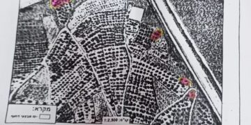
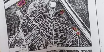
The commander of the Israeli Occupation Army, Roni Alov, issued a military seizure order on 9.8 dunums from Ya'bad town on the claim of "security purposes". The order was issued in March but was delivered in May and hanged at the Dotan military checkpoint. Ironically, the order had a seven day deadline for objection, starting from the date of issuance, which is two months ago.
The military order number ( 17/5/ت) aims at seizing lands to create a closed military zone through setting up a fence (1km* 10m) on both sides of the bypass road leading to Mevo Dotan and Hermesh colonies, south Ya'bad town.
It is reported that the occupation showed information about the targeted areas as detailed in the below table:
|
No. of natural block |
No. of parcels |
|
41 |
10،26،44-46،48،64،65،67 |
|
42 |
1،9،10،12،13،35،36،39ـ41 |
|
43 |
32-35،38-41، |
|
29 |
4-7،42-47،59، 87 |
|
40 |
17،20،25 |
|
39 |
17-23،38-40،42-45 |
|
37 |
62، 64-66، 68 |


Previous procedures:
It should be marked that Israeli Occupation Forces set up another fence in 2015. The recent set-up fence comes within a plan to take over lands and hinder Palestinian farmers' movement and access to lands.
"This means that the area has become a closed military zone where Palestinian farmers can’t exploit their agricultural lands in the nearby of the buffer zone of Mevo Dotan colony ", said the mayor of Ya’bad Yousef Atatra

Photos 1-2: the targeted road with a view of the fence
Photo 4: segment of the fence established in 2015
About Ya’bad village:
The village is located 18 km to the west of Jenin governorate. It is edged by the villages of Al-Khiljan, Al-Tarm, Al-Araqa, Imraiha and Khirbet Mas’oud, Zabda from the north, Qaffin village from the west, Al-Qaffriat village from the east and Arraba, Al-Nazla Al-Sharqiya and Baqa Al-Sharqiya from the south.
With a total land area of 29572 dunums, of which 1814 dunums are the built-up area, Ya’bad is inhabited by 13640 people (2007).
The occupation confiscated 1840 dunums from Ya’bad; the confiscation is clarified as follows:
- Israeli colonies confiscated 483 dunums as follows:
|
|
Year of establishment |
Confiscated area\dunum |
No. of colonists |
|
Mevo Dotan |
|
|
|
|
Jarmish |
|
|
|
|
|
|
|
|
- Bypass roads number (569 & 585) confiscated 1357 dunums.
The lands of Ya’bad are classified, according to Oslo Accords, as follows:
- 1674 dunums are classified as area “A”
- 8124 dunums are classified as area “B”
- 19774 dunums are classified as area “C”
Prepared by
The Land Research Center
LRC


