• About The Project
  • Palestine in Century
  • Selected Maps
  • Glossary
  • About ARIJ
  • About LRC
  • By Year
    • Case Studies By Year
    • Daily Report By Year
Monday, May 18, 2026
POICA
No Result
View All Result
  • Home
  • Settlements
    • New Israeli Settlements
    • Settlement Expansion
  • Israeli Violations
    • Agriculture
    • Confiscation
    • Demolition
    • Environment
    • Eviction of Palestinians
    • Settlers Attacks
  • Bypass Roads
  • Israeli Plans
  • Segregation
    • Checkpoints
    • Closure
    • Separation Plans
  • Military Orders
  • Reports
    • Daily Report
    • Monthly Report
    • Quarterly Report
No Result
View All Result
POICA
No Result
View All Result

Israeli Occupation Forces notify structures of stop-work in Tulkarm governorate

February 9, 2017
in Military Orders
إخطارات بوقف البناء لمساكن ومزارع  ورش حرفية في قرية شوفة


  • Violation: serving stop-work orders on structures
  • Location:  Shofa village- Tulkarm
  • Date: January 18, 2017
  • Perpetrators: Inspection Sub-Committee – the Israeli Occupation Civil Administration.
  • Victims: six Palestinian families

Details:

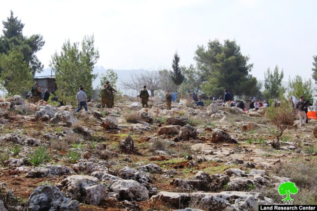
Israeli Occupation Forces notified on January 18, 2017 some residences, structures, workshops and farms of stop-work on the claim of them being built without proper license\permit. According to the orders, the affected citizens were given a deadline until February 09, 2017 to complete all licensing procedures. This comes in time with the hearing session of Planning and Construction Committee- Israel Civil Administration in the court of Beit El colony to consider the legal status of the structure. The following table shows information about the affected people and their properties:

Affected citizen

Family

Minors

Area\m-2

No. of threatened  structures

Type of structure

No. of order

Photo

Ahmad Droubi

8

3

160

1

Foundation of a residence

203641

1

250

1

Barracks for cows

60

2

Mobile room with a toilet unit

Mohammad Droubi

3

1

240

1

Under construction house

203642

2

Tayseer Hamid

7

5

80

1

Car parts workshop

203648

3+4

60

1

Mechanic workshop

300

1

Car part yard

45

3

Room+ kitchen+ toilet

320

1

Under construction house

203649

5

Yousef Hannoun

8

4

220

1

Chicken farm

203647

6+7

240

1

Chicken farm

Mohammad Natour

11

6

150

1

Under construction house

203645

8+9

40

1

Under construction house

Sameer Hamid

4

2

160

1

Under construction house

203646

10

Total

41

21

2325

17


Source : Field observation- Department of Monitoring Israeli Violations- Land Research Center-2017

About Shofa:

9.5km to the southeast of Tulkarm city, Shofa is inhabited with 2829 people on a total area of 10,969 dunums, of which 343 dunums are considered the built-up area. It should be marked that the colony of Avnei Hefetz was established on 722 confiscated  dunums from Shofa village in 1987. Now, it  populates 964  colonists. 

To the west of Shofa, Enav colony was established on confiscated lands from the village in 198. The colony is of 1566 dunums and has a built-up area of 696 where 550 colonists live (2005). The bypass roads, especially took over 420 dunums from the village's lands. According to Oslo Accords, the village's lands are classified as follows:

  • 1143 dunums are classified as area B
  • 9826 dunums are classified as area C


Prepared by
 The Land Research Center
LRC
 

Recommended For You

إقامة منطقة عسكرية عسكرية داخل أراضي (أ) في جنين

by arij
May 18, 2026
0
إقامة منطقة عسكرية عسكرية داخل أراضي (أ) في جنين

   في السابع من شهر أيار من العام 2026، وزعت سلطات الاحتلال الإسرائيلي أمرا عسكريا جديدة على أهالي مدينة جنين يقضي بمصادرة 7.2 دونما من الأراضي الفلسطينية في...

Read moreDetails

“بمساحة اجمالية 177 دونما من أرضي البيرة وبيتين”, طريق استيطاني لخدمة البؤر الاستيطانية في محافظة رام الله

by arij
May 18, 2026
0
“بمساحة اجمالية 177 دونما من أرضي البيرة وبيتين”, طريق استيطاني لخدمة البؤر الاستيطانية في محافظة رام الله

في الحادي عشر من شهر أيار من العام 2026, نشرت دائرة أراضي إسرائيل اعلانا جديدا يقضي بمصادرة المزيد من الأراضي الفلسطينية في محافظة رام الله لأغراض استيطانية في...

Read moreDetails

“في خدمة مستوطنة ناحال حيلتس”, طريق استيطاني إسرائيلي جديد على أراضي بتير وبيت جالا في محافظة بيت لحم

by arij
May 18, 2026
0
“في خدمة مستوطنة ناحال حيلتس”, طريق استيطاني إسرائيلي جديد على أراضي بتير وبيت جالا في محافظة بيت لحم

تواصل سلطات الاحتلال الإسرائيلي إحكام سيطرتها على المزيد من الأراضي الفلسطينية في الضفة الغربية المحتلة، وهذه المرة من خلال استهداف أراضي محافظة بيت لحم. ففي السادس والعشرين من...

Read moreDetails

مناطق نفوذ المستوطنات ودورها في إعادة تشكيل الجغرافيا الفلسطينية

by arij
April 23, 2026
0
مناطق نفوذ المستوطنات ودورها في إعادة تشكيل الجغرافيا الفلسطينية

أصدرت سلطات الاحتلال الإسرائيلي في العاشر من شهر نيسان 2026 الكراسة رقم (273)، وهي وثيقة تضم مجموعة من المناشير والأوامر والتعيينات الإسرائيلية المتعلقة بالجوانب الأمنية والعسكرية والإدارية، إضافة...

Read moreDetails

INFOGRAPHIC: Mapping Control – Israeli Militray Orders across the occupied West Bank – 2025

by arij
April 16, 2026
0

    Prepared by:   The Applied Research Institute – Jerusalem

Read moreDetails
Next Post
الاحتلال يمنع المزارعين من زراعة أراضيهم شرق بلدة ترقوميا

الاحتلال يمنع المزارعين من زراعة أراضيهم شرق بلدة ترقوميا

LATEST NEWS

إقامة منطقة عسكرية عسكرية داخل أراضي (أ) في جنين

إقامة منطقة عسكرية عسكرية داخل أراضي (أ) في جنين

by arij
May 18, 2026
0

........................................................

النكبة الفلسطينية في ذكراها الثامنة والسبعين: من التطهير العرقي إلى الإبادة وإعادة هندسة الجغرافيا الفلسطينية 

النكبة الفلسطينية في ذكراها الثامنة والسبعين: من التطهير العرقي إلى الإبادة وإعادة هندسة الجغرافيا الفلسطينية 

by arij
May 18, 2026
0

........................................................

“بمساحة اجمالية 177 دونما من أرضي البيرة وبيتين”, طريق استيطاني لخدمة البؤر الاستيطانية في محافظة رام الله

“بمساحة اجمالية 177 دونما من أرضي البيرة وبيتين”, طريق استيطاني لخدمة البؤر الاستيطانية في محافظة رام الله

by arij
May 18, 2026
0

........................................................

“في خدمة مستوطنة ناحال حيلتس”, طريق استيطاني إسرائيلي جديد على أراضي بتير وبيت جالا في محافظة بيت لحم

“في خدمة مستوطنة ناحال حيلتس”, طريق استيطاني إسرائيلي جديد على أراضي بتير وبيت جالا في محافظة بيت لحم

by arij
May 18, 2026
0

........................................................

flag_yellow_lowEU-PfP-Logo

This website and its content were initiated in 1993 by the Applied Research Institute – Jerusalem (ARIJ) and the Land Research Center (LRC) with the support from the European Union up until 2023. Since then, the Applied Research Institute – Jerusalem (ARIJ) has taken over the continued development and maintenance of the website. The views expressed remain solely those of ARIJ) and do not necessarily reflect those of the European Union.

© 2026 Copyright | ARIJ | All Rights reserved.

No Result
View All Result
  • Home
  • Settlements
    • New Israeli Settlements
    • Settlement Expansion
  • Israeli Violations
    • Agriculture
    • Confiscation
    • Demolition
    • Environment
    • Eviction of Palestinians
    • Settlers Attacks
  • Bypass Roads
  • Israeli Plans
  • Segregation
    • Checkpoints
    • Closure
    • Separation Plans
  • Military Orders
  • Reports
    • Daily Report
    • Monthly Report
    • Quarterly Report

© 2026 Copyright | ARIJ | All Rights reserved.