
In the early morning of August 10, 2016, the Israeli occupation bulldozers backed by Army forces raided Iskaka village to the north of Salfit city and started leveling lands and uprooting trees in the village. Iskaka village council reported that more than 250 Olive trees were uprooted and around 30 dunums others were leveled in an area locally known as “Al Bayyada area”, allegedly for being classified as “State Land”. The targeted site lies adjacent to Iskaka village’s built-up area, to its southeast and is very close to Nofei Nehmia outpost, which was illegally established on lands of Iskaka village back in 2002.
The outpost of Nofei Nehmia lies adjacent to the settlement of Rechalim and is located within its boundaries, based on the Israeli classifications of settlements and outposts boundaries in the occupied West Bank. It is bordered by Iskaka and Yasuf villages from the north, Ariel settlement and Salfit city from the west, Rechalim settlement from the east and As Sawiya and Al Luban Ash Sharqi villages from the south. Today the outpost has almost 40 structures including public facilities and is home to around 30 settler families.
Apparently, the Israeli actions in the area come as part of the plan to expand the outpost, under plan number יוש/ 4/ 171 (Nofei Nehmia neighborhood (grounds and buildings and public institutions). The purpose of the plan comes to:
- (1) Rezone the land from Agricultural to open spaces and buildings and public facilities and roads.
- (2) To Determine the permitted uses of the different land zoning.
- (3) to set regulations and building restrictions in the field.
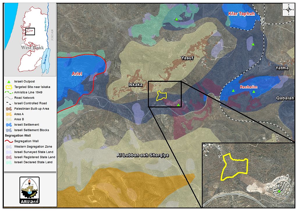
See Map 1: Targeted site in Iskaka village, Salfit Governorate
Legalization of three settlements in the occupied West Bank
In April 2012, the Israeli Prime Minister, Benjamin Netanyahu, approved plans to legalize three illegal Israeli settlements in the occupied West Bank following recommendations of the ex-Israeli Defense Minister that time, Ehud Barak, to formalize the status of Bruchin, Rechalim and Sensana settlements. According to Netanyahu, Bruchin settlement is proposed to be part of Eli Zahav (2 km away from Eli Zahav) while Rechalim settlement is proposed to be part of Kfar Taphuh settlement (1.5 km away from Kfar Taphuh) and Sensana settlement to be part of Eshkelot settlement (2.5 km away from it). The Israeli decision to include the settlements of Bruchin, Rechalim and Sensana within the administrative boundaries of Eli Zahav, Kfar Tepouah and Ashkelot was not random, but rather comes as part of the plan to legalize the three illegal settlements instead of dismantling them, where for Netanyahu, it is way to provide settlers with more lands in the area for future settlement expansion despite the catastrophic territorial discontinuity that will result from this decision. See Map 2
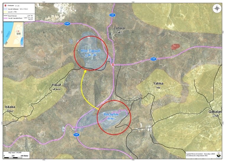
Map 2: Rechalim and Kfar Taphuh settlements
Later in August 2012, the Israeli PEACENOW movement reported that following the Israeli Government’s decision of April 2012 to retroactively legalize three settlements in the occupied West Bank (Rechalim, Sansana and Bruchin), the so- called “Israeli Commander of the Central Command” issued a military order officially establishing the boundaries of Rechalim settlement in the oWB. PEACENOW added that despite the fact that the Israeli Government’s decision did not directly mention the Nofei Nehemia outpost as part of the settlement, but the boundaries of the new settlement as revealed by the State of Israel include the outpost of Nofei Nehemia which is located approximately 2 km west of it, as a “neighborhood” of Rechelim[1].
Additionally, the expansion of Nofei Nehmia outpost paves the way for more land takeover in the area for the sake of its future expansion; thus cutting the way for Palestinians of Iskaka village to build and expand in the future in the only land space left for them.
Moreover, Nofei Nehmia outpost along with the nearby settlements of Rechalim, Kfar Taphuh, Eli, Shilo and Migdalim and 23 other Israeli outposts in the area form a bloc of settlements and outposts that act like a territorial contiguity between Ariel settlement bloc in the west and the Jordan Valley area in the east (the locally known as the “Eastern Segregation Zone” due the Israeli restrictions imposed on it with regard to Land Use, Mobility and Development. Such a bloc will cut off the territorial contiguity of the Palestinian communities surrounding them and eventually annex the land available to Palestinians to expand in the future. See Map 3
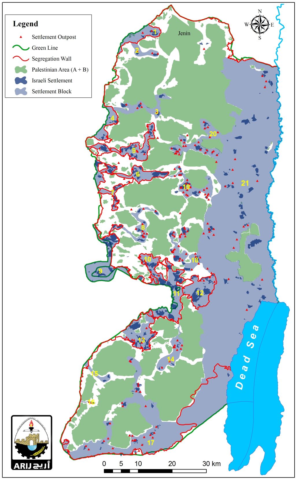
Map 2: Israeli settlement Blocs in the occupied West Bank
[1] The Government Secretly Approved another Outpost: Nofei Nehemia
http://peacenow.org.il/eng/Nofei-Nehemia
Prepared By
The Applied Research Institute – Jerusalem
ARIJ


