• About The Project
  • Palestine in Century
  • Selected Maps
  • Glossary
  • About ARIJ
  • About LRC
  • By Year
    • Case Studies By Year
    • Daily Report By Year
Saturday, May 10, 2025
POICA
No Result
View All Result
  • Home
  • Settlements
    • New Israeli Settlements
    • Settlement Expansion
  • Israeli Violations
    • Agriculture
    • Confiscation
    • Demolition
    • Environment
    • Eviction of Palestinians
    • Settlers Attacks
  • Bypass Roads
  • Israeli Plans
  • Segregation
    • Checkpoints
    • Closure
    • Separation Plans
  • Military Orders
  • Reports
    • Daily Report
    • Monthly Report
    • Quarterly Report
No Result
View All Result
POICA
No Result
View All Result

New expansion Plan in Kfar Tapuah settlement

August 30, 2016
in Settlement Expansion
New expansion Plan in Kfar Tapuah settlement


On the 25th of August 2016, the Israeli High Planning council in the so-called Israeli Civil Administration submitted the Town Planning Scheme No. 131/5, in the Al Quds Daily Newspaper, for the public review. Where according to the ad, the Israeli Land Authority will change the status of the land for the expansion of the illegal Israeli settlement of Kfar Tapuah, east of Salfit Governorate. See the ad as its published in Al Quds Newspaper:

2

The Town Planning Scheme (TPS)  No, 131/5 aims to change  the TPS No. 131 and S/15, which targeted land in the plot No. 12 part of Jabal Abu Swiar area in Yasuf village, northeast of Salfit Governorate,  within the border of the illegal Israeli settlement of Kfar Tapuah.  The objective of the plan is to change the status of the land from residential area type “A” (for one family) to residential area type “A 1” (for two families).

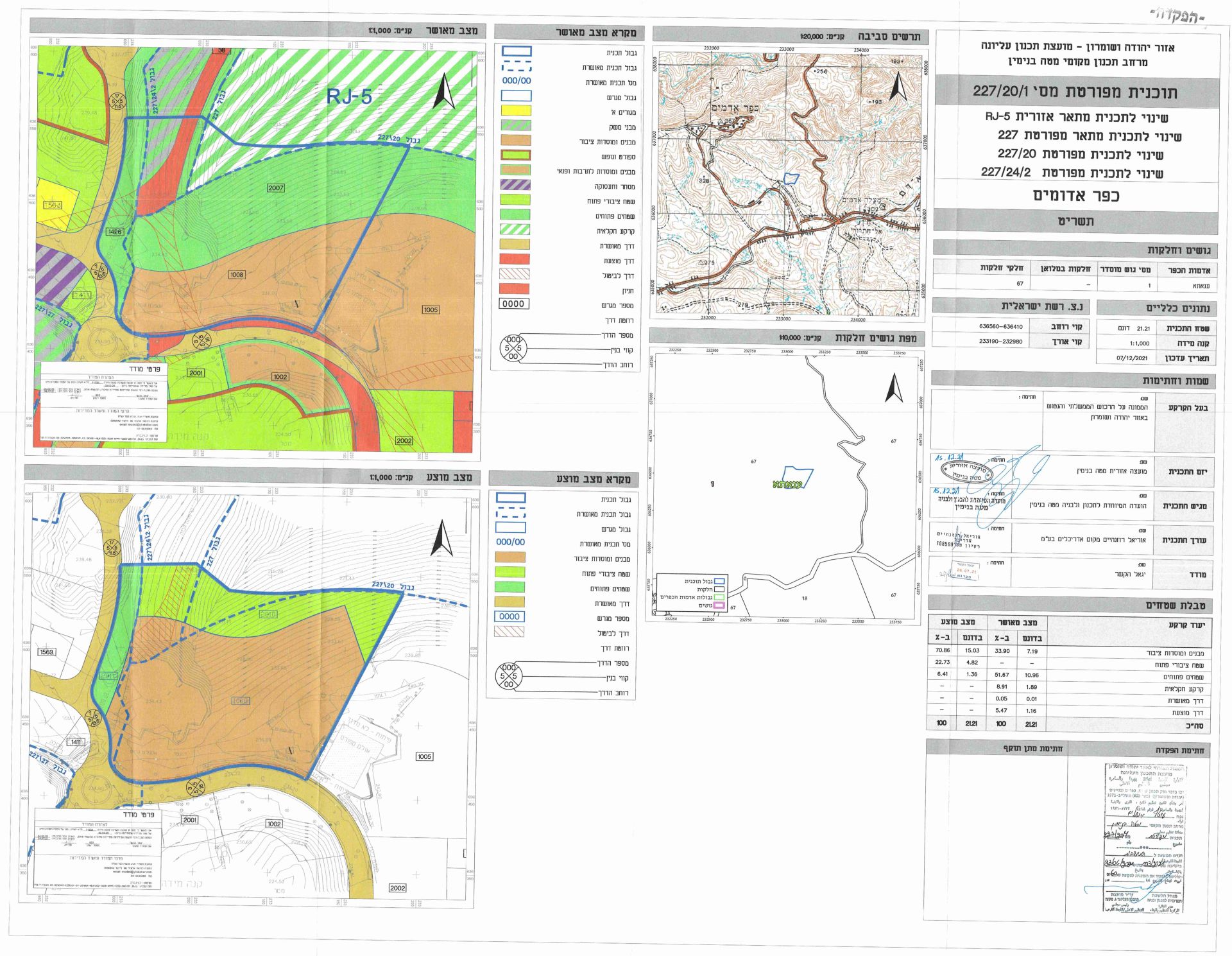
According to the article No. 20/24 from the Israeli City planning law for villages and buildings No. 79 for the year 1966, the Israeli settlement subcommittee of the Israeli Land Authority declared the deposit of the Town Planning Scheme (TPS) No. 131/5 in Karni Shomron settlement (the industrial zone), changing the regional master plan S/15 and Town Planning Scheme No. 131. See the image below for the Israeli TPS No. 131

131


The Israeli Town Planning Scheme No. 131/5

On the 30th of December 2015, the Israeli Civil Administration carried out a meeting to discuss the TPS No. 131/5 for the Israeli settlement of “Kfar Tapuah”, which targeted 3.342 dunums of land located in the center of Kfar Tapuah settlement, where a new 6 housing units will be added to the residential block No. 12.  Photocopy of “Minutes of the meeting”

File (40)_Page_01File (40)_Page_02File (40)_Page_17

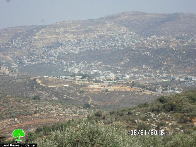
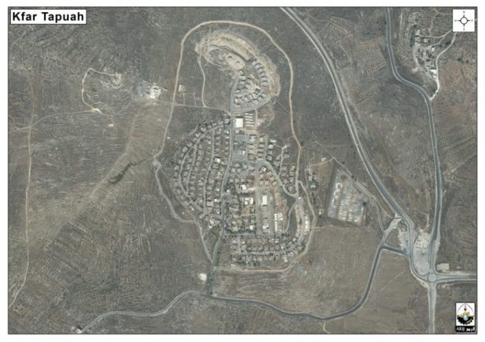
The Illegal Israeli Settlement of Kfar Tapuah

Kfar Tapuah established on 1978 on Palestinian lands of Yasuf village, northeast of Salfit Governorate. Kfra Tapuah settlement area reach to 651 dunums of land. The settlement inhabited by 900 Israeli settlers.

The Kfar Tapuah settlement located within the “Kfar Tapuah” settlement bloc encompasses also “Tapuah” Israeli military base, and “Tapuah” military checkpoint, known to Palestinians as “Za'tara” checkpoint.

The Kfar Tapuah settlement bloc known also as “corroder area” which link between the “Western Segregation Zone” (the area created after the construction of the Israeli Segregation wall and located between the route of the Segregation wall and the Armistice Line 1949 (Green Line)) and the “Eastern Segregation Zone” (the area located along the Jordanian- Palestinian borders).

Noted that, the Israeli colonial corroders is a very strategic area for the Israeli Occupation, where it keen to keep its control over these areas for “security and colonial considerations” and mainly to find a geographical contiguity between the Israeli settlements and outposts in all parts on the oPt.

To conclude

The existence of Israeli settlements in the West Bank and their expansions are Illegal and contradict with the international law, and most specifically United Nations Security Council Resolutions: 237 (1967), 271 (1969), 446 (1979), 452 (1979), and 465 (1980), among others.

Resolution 446 March 22, 1979 calls on Israel to rescind its previous measures and to desist from taking any action which would result in changing the legal status and geographical nature and materially affecting the demographic composition of the Arab territories occupied since 1967, including Jerusalem and, in particular, not to transfer parts of its own civilian population into the occupied Arab territories'

Also the resolution 452 of the 1979 “calls upon the Government and people of Israel to cease, on an urgent basis, the establishment, construction and planning of settlements in the Arab territories occupied since 1967, including Jerusalem.”

The Fourth Geneva Convention prohibits an occupying power from transferring citizens from its own territory to the occupied territory (Article 49). 

The Hague Regulations prohibit an occupying power from undertaking permanent changes in the occupied area unless these are due to military needs in the narrow sense of the term, or unless they are undertaken for the benefit of the local population.

Prepared By  
The Applied Research Institute – Jerusalem
ARIJ

Tags: New planSettlement Expansion

Recommended For You

إسرائيل تمضي قدمًا في مخطط استيطاني جديد على أراضي مدينة بيت جالا، في انتهاك للقانون الدولي وحرمان الفلسطينيين من أراضيهم

by arij
April 29, 2025
0
Israel Advances Settlement Plan on Ancient Olive Groves on lands of Beit Jala city, Violating International Law and depriving Palestinians their lands

  في أواخر شهر شباط من العام 2025، صادقت دولة الاحتلال الإسرائيلي على مخطط استيطاني جديدة لبناء حي سكني للمستوطنين على مساحة 22.2 دونما من الأراضي الفلسطينية لتابعة...

Read moreDetails

سلطات الاحتلال الإسرائيلي تصادر 64 دونما شمال مدينة بيت لحم لإقامة موقفا للحافلات

by arij
October 19, 2023
0
سلطات الاحتلال الإسرائيلي تصادر 64 دونما شمال مدينة بيت لحم لإقامة موقفا للحافلات

  في السابع من شهر أيلول من العام 2023, صادقت بلدية الاحتلال الإسرائيلي في القدس المحتلة على مخطط استيطاني جديد من شأنه أن يصادر مساحات شاسعة من أراضي...

Read moreDetails

Israeli Settlements in the Occupied West Bank: from “outposts” to urban blocks

by arij
May 20, 2023
0
Israeli Settlements in the Occupied West Bank: from “outposts” to urban blocks

  The Applied Research Institute – Jerusalem (ARIJ) In cooperation with Palestine Economic Policy Research Institute (MAS)   Preface Legalizing nine Israeli settlement outposts in the occupied West...

Read moreDetails

استكمال انشاء حي استعماري تابع لمستعمرة ” الكانا” على أراضي قرية مسحة / محافظة سلفيت

by arij
November 1, 2022
0
استكمال انشاء حي استعماري تابع لمستعمرة ” الكانا” على أراضي قرية مسحة / محافظة سلفيت

  الانتهاك: توسع استيطاني. الموقع: قرية مسحة / محافظة سلفيت. تاريخ الانتهاك: تشرين أول 2022. الجهة المعتدية: مستعمرة " الكانا". الجهة المتضررة: أهالي قرية مسحة.  تفاضيل الانتهاك:   استكمل...

Read moreDetails

بواقع “4,762 دونما”, سلطات الاحتلال تصادق على عددا من المخططات الاستيطانية منذ بداية شهر تشرين أول 2022

by arij
October 19, 2023
0
بواقع “4,762 دونما”, سلطات الاحتلال تصادق على عددا من المخططات الاستيطانية منذ بداية شهر تشرين أول 2022

  كشفت سلطات الاحتلال الإسرائيلي منذ بداية شهر تشرين الأول من العام 2022, عن مصادقتها لعددا من المخططات الاستيطانية في عددا من المستوطنات الإسرائيلية في الضفة الغربية المحتلة....

Read moreDetails
Next Post
الإعلان عن إيداع مخطط تنظيم تفصيلي جديد لمستعمرة ” كفار تبواح” على حساب أراضي قرية ياسوف

الإعلان عن إيداع مخطط تنظيم تفصيلي جديد لمستعمرة " كفار تبواح" على حساب أراضي قرية ياسوف

LATEST NEWS

الأراضي الفلسطينية بين الذرائع الأمنية والأطماع الاستيطانية – “الأمن، الآثار، والطبيعة كحجج لاقتلاع الفلسطينيين من أراضيهم”

by arij
April 15, 2025
0

........................................................

الطرق الالتفافية الاسرائيلية وأثرها على البيئة الفلسطينية

انتهاك للطبيعة والهوية في الأراضي الفلسطينية المحتلة

by arij
March 17, 2025
0

........................................................

Israel Advances Settlement Plan on Ancient Olive Groves on lands of Beit Jala city, Violating International Law and depriving Palestinians their lands

إسرائيل تمضي قدمًا في مخطط استيطاني جديد على أراضي مدينة بيت جالا، في انتهاك للقانون الدولي وحرمان الفلسطينيين من أراضيهم

by arij
April 29, 2025
0

........................................................

Israel Advances Settlement Plan on Ancient Olive Groves on lands of Beit Jala city, Violating International Law and depriving Palestinians their lands

Israel Advances Settlement Plan on Ancient Olive Groves on lands of Beit Jala city, Violating International Law and depriving Palestinians their lands

by arij
April 29, 2025
0

........................................................

flag_yellow_lowEU-PfP-Logo

This website has been produced with the assistance of the European Union. The contents of this publication are the sole responsibility of ARIJ & LRC and can in no way be taken to reflect the views of the European Union.

© 2025 Copyright ARIJ . All Rights reserved. .

No Result
View All Result
  • Home
  • Settlements
    • New Israeli Settlements
    • Settlement Expansion
  • Israeli Violations
    • Agriculture
    • Confiscation
    • Demolition
    • Environment
    • Eviction of Palestinians
    • Settlers Attacks
  • Bypass Roads
  • Israeli Plans
  • Segregation
    • Checkpoints
    • Closure
    • Separation Plans
  • Military Orders
  • Reports
    • Daily Report
    • Monthly Report
    • Quarterly Report

© 2025 Copyright ARIJ . All Rights reserved. .