• About The Project
  • Palestine in Century
  • Selected Maps
  • Glossary
  • About ARIJ
  • About LRC
  • By Year
    • Case Studies By Year
    • Daily Report By Year
Sunday, May 11, 2025
POICA
No Result
View All Result
  • Home
  • Settlements
    • New Israeli Settlements
    • Settlement Expansion
  • Israeli Violations
    • Agriculture
    • Confiscation
    • Demolition
    • Environment
    • Eviction of Palestinians
    • Settlers Attacks
  • Bypass Roads
  • Israeli Plans
  • Segregation
    • Checkpoints
    • Closure
    • Separation Plans
  • Military Orders
  • Reports
    • Daily Report
    • Monthly Report
    • Quarterly Report
No Result
View All Result
POICA
No Result
View All Result

Israeli building schemes to expand the Karni Shomron Industrial area

October 13, 2016
in Settlement Expansion
Israeli building schemes to expand the Karni Shomron Industrial area


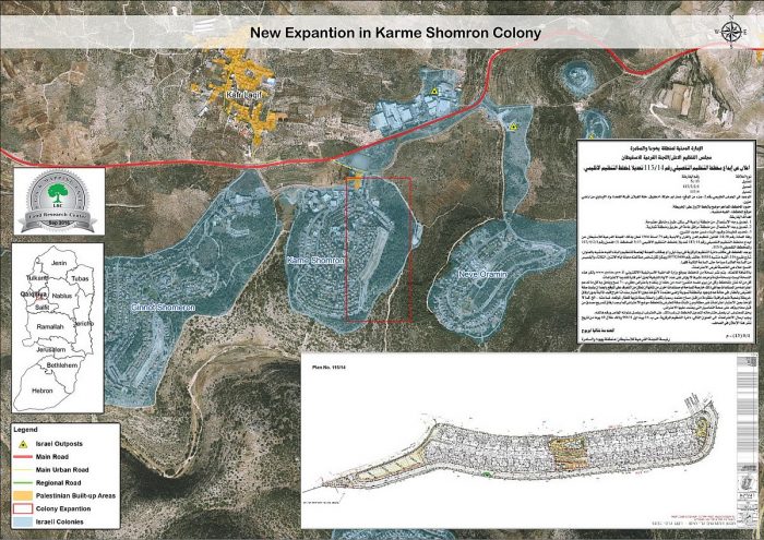
  • Violation:  two building schemes for a colony
  • Location:  villages south Qalqiliya city
  • Date: August 02+28, 20146
  • Perpetrators:  Israeli High Planning Council- co-called Israeli Civil Administration
  • Victims:  residents of villages

Details:

On the 25th of August 2016, the Israeli High Planning Council in the co-called Israeli Civil Administration published the building scheme No. 117/17, in the Al Quds Daily Newspaper, for the public review. According to the aforementioned scheme published in Al Quds Newspaper, the Israeli Land Authority (ILA) will change the status of the land in the  following location for the expansion of Karni Shomron industrial area:

  • plot No. 4 part of  Hareq Durs and Al Dhohor areas
  • plot No. 1 part of Ar Rassif area in Kafr Laqif village, east of Qalqiliyah city
  • plot No. 11 part of Adh Dhahir area in Hajja village, east of Qalqiliyah city,

1

photo 1: copy of the advertisement in Al-Quds newspaper on August 25, 2016


It should be also marked that the military administration declared on August 02, 2016 an advertisement about the master plan no. 1/115  issued by Supreme Planning Council, which includes seizure of some lands.

According to the advertisement, the target lands are located in the natural block no. 2; more specifically in the locations of Imar Abu Khawala, Khallet AL-Ghilan, Wunet Al-Qa'deh and  Wad Al-Linawi.

It is reported that the plan intends to transform a massive agricultural area into a residential one for the sake of attracting more colonists to the area. Also, the plan will reinforce the infrastructure of the colony though adding new governmental buildings, parks and recreational areas.

Objectives of the plan:

  • Change the status of some lands from agricultural to residential, roads and open areas
  • Change the status of some lands from public facilities to roads and commercial areas
  • Setting up rules and regulations of construction within the project


4

Photo 2: copy of the advertisement in Al-Quds newspaper on August 02, 2016

kshomron3

photo 3: copy of the building scheme no. 14/115

shomron

photo 4: an aerial image illustrating the targeted lands by the scheme


About Azzun Attma:

Located 8km to Qalqiliya city with a total area of 9,472 dunums, of which 1,054 dunums are the village’s built-up area, Azzun is inhabited by 7,821 people (2007). The occupation confiscated vast area from the village for the favor of colonization and the apartheid wall; the areas are detailed as follows:

  • 276 dunums were confiscated for Maale Shamron colony that was established in 1980.
  • 417 dunums were confiscated for the bypass road number 55

It should be marked that the vast majority of Azzun lands (6,927 dunums) is classified as area “C” according to Oslo accords; areas that are controlled by the Israeli occupation. The village has zero percentage of area “A” that is under the control of Palestinian Authority. As for other classifications, the village has 2,546 dunums classified as area “B”. (Geographical Information System- Land Research Center)                       

Establishing new Israeli colonies is a direct violation of the following international laws and conventions :

  • UN Security Council resolution 446, article 3" Calls once more upon Israel, as the occupying Power, to abide scrupulously by the 1949 Fourth Geneva Convention, to rescind its previous measures and to desist from taking any action which would result in changing the legal status and geographical nature and materially affecting the demographic composition of the Arab territories occupied since 1967, including Jerusalem, and, in particular, not to transfer parts of its own civilian population into the occupied Arab territories;"
  • Un Security Council resolution 452, article 3"Calls upon the Government and people of Israel to cease, on an urgent basis, the establishment, construction and planning of settlements in the Arab territories occupied since 1967, including Jerusalem;"
  • Convention (IV) relative to the Protection of Civilian Persons in Time of War. Geneva, 12 August 1949. Article 49 :

"Individual or mass forcible transfers, as well as deportations of protected persons from occupied territory to the territory of the Occupying Power or to that of any other country, occupied or not, are prohibited, regardless of their motive."


Prepared by
 The Land Research Center
LRC


Recommended For You

إسرائيل تمضي قدمًا في مخطط استيطاني جديد على أراضي مدينة بيت جالا، في انتهاك للقانون الدولي وحرمان الفلسطينيين من أراضيهم

by arij
April 29, 2025
0
Israel Advances Settlement Plan on Ancient Olive Groves on lands of Beit Jala city, Violating International Law and depriving Palestinians their lands

  في أواخر شهر شباط من العام 2025، صادقت دولة الاحتلال الإسرائيلي على مخطط استيطاني جديدة لبناء حي سكني للمستوطنين على مساحة 22.2 دونما من الأراضي الفلسطينية لتابعة...

Read moreDetails

سلطات الاحتلال الإسرائيلي تصادر 64 دونما شمال مدينة بيت لحم لإقامة موقفا للحافلات

by arij
October 19, 2023
0
سلطات الاحتلال الإسرائيلي تصادر 64 دونما شمال مدينة بيت لحم لإقامة موقفا للحافلات

  في السابع من شهر أيلول من العام 2023, صادقت بلدية الاحتلال الإسرائيلي في القدس المحتلة على مخطط استيطاني جديد من شأنه أن يصادر مساحات شاسعة من أراضي...

Read moreDetails

Israeli Settlements in the Occupied West Bank: from “outposts” to urban blocks

by arij
May 20, 2023
0
Israeli Settlements in the Occupied West Bank: from “outposts” to urban blocks

  The Applied Research Institute – Jerusalem (ARIJ) In cooperation with Palestine Economic Policy Research Institute (MAS)   Preface Legalizing nine Israeli settlement outposts in the occupied West...

Read moreDetails

استكمال انشاء حي استعماري تابع لمستعمرة ” الكانا” على أراضي قرية مسحة / محافظة سلفيت

by arij
November 1, 2022
0
استكمال انشاء حي استعماري تابع لمستعمرة ” الكانا” على أراضي قرية مسحة / محافظة سلفيت

  الانتهاك: توسع استيطاني. الموقع: قرية مسحة / محافظة سلفيت. تاريخ الانتهاك: تشرين أول 2022. الجهة المعتدية: مستعمرة " الكانا". الجهة المتضررة: أهالي قرية مسحة.  تفاضيل الانتهاك:   استكمل...

Read moreDetails

بواقع “4,762 دونما”, سلطات الاحتلال تصادق على عددا من المخططات الاستيطانية منذ بداية شهر تشرين أول 2022

by arij
October 19, 2023
0
بواقع “4,762 دونما”, سلطات الاحتلال تصادق على عددا من المخططات الاستيطانية منذ بداية شهر تشرين أول 2022

  كشفت سلطات الاحتلال الإسرائيلي منذ بداية شهر تشرين الأول من العام 2022, عن مصادقتها لعددا من المخططات الاستيطانية في عددا من المستوطنات الإسرائيلية في الضفة الغربية المحتلة....

Read moreDetails
Next Post
هدم غرف سكنية وحظائر للأغنام في تجمع المعازي البدوي شمال بلدة جبع

هدم غرف سكنية وحظائر للأغنام في تجمع المعازي البدوي شمال بلدة جبع

LATEST NEWS

الأراضي الفلسطينية بين الذرائع الأمنية والأطماع الاستيطانية – “الأمن، الآثار، والطبيعة كحجج لاقتلاع الفلسطينيين من أراضيهم”

by arij
April 15, 2025
0

........................................................

الطرق الالتفافية الاسرائيلية وأثرها على البيئة الفلسطينية

انتهاك للطبيعة والهوية في الأراضي الفلسطينية المحتلة

by arij
March 17, 2025
0

........................................................

Israel Advances Settlement Plan on Ancient Olive Groves on lands of Beit Jala city, Violating International Law and depriving Palestinians their lands

إسرائيل تمضي قدمًا في مخطط استيطاني جديد على أراضي مدينة بيت جالا، في انتهاك للقانون الدولي وحرمان الفلسطينيين من أراضيهم

by arij
April 29, 2025
0

........................................................

Israel Advances Settlement Plan on Ancient Olive Groves on lands of Beit Jala city, Violating International Law and depriving Palestinians their lands

Israel Advances Settlement Plan on Ancient Olive Groves on lands of Beit Jala city, Violating International Law and depriving Palestinians their lands

by arij
April 29, 2025
0

........................................................

flag_yellow_lowEU-PfP-Logo

This website has been produced with the assistance of the European Union. The contents of this publication are the sole responsibility of ARIJ & LRC and can in no way be taken to reflect the views of the European Union.

© 2025 Copyright ARIJ . All Rights reserved. .

No Result
View All Result
  • Home
  • Settlements
    • New Israeli Settlements
    • Settlement Expansion
  • Israeli Violations
    • Agriculture
    • Confiscation
    • Demolition
    • Environment
    • Eviction of Palestinians
    • Settlers Attacks
  • Bypass Roads
  • Israeli Plans
  • Segregation
    • Checkpoints
    • Closure
    • Separation Plans
  • Military Orders
  • Reports
    • Daily Report
    • Monthly Report
    • Quarterly Report

© 2025 Copyright ARIJ . All Rights reserved. .