On May 31, 2016, an Israeli daily newspaper revealed that the designated team of the Israeli Civil Administration (ICA) – the blue line team – concluded its task and procedures to register (confiscate) 15,000 acres (+62000 dunums) as “state land during the year 2015.
According to the newspaper the Israeli Civil Administration related to the Israeli Occupation Army “re-mapped over 15 thousand acres in the West Bank in the year 2015 and suggested an intention to embark on wide-scale settlement construction”.
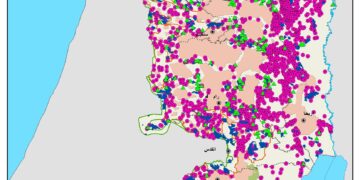
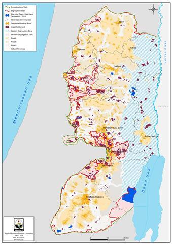
An analysis conducted by the geo-informatics Department at ARIJ showed that during the year 2015 , the “blue line team” approved the registration and allocation of more than 62,000 dunums as state land” to expand 10 illegal settlements in the oPt; in addition to Tarqumya Terminal in Hebron Governorate. See table 1 below:
|
Lands approved by Blue Line Team to be expropriated as “State Land during the year 2015
|
||||||
|
No. |
Settlement |
Governorate |
Date of Est. |
Population |
Area dunums |
Blue Line Team plan- Dunums |
|
1. |
Nikodim |
Bethlehem |
1982 |
1461 |
412 |
963 |
|
2. |
Mitzpe Shalim |
Bethlehem |
1980 |
233 |
420 |
47,463 |
|
3. |
Ramat Kharsina |
Hebron |
1983 |
*** |
828 |
112 |
|
4. |
Shem’a |
Hebron |
1985 |
411 |
553 |
1,365 |
|
5. |
Tene |
Hebron |
1982 |
749 |
484 |
2,398 |
|
6. |
Nili |
Ramallah |
1981 |
942 |
704 |
1,967 |
|
7. |
Na’leh |
Ramallah |
1982 |
1,094 |
880 |
398 |
|
8. |
Gittit |
Nablus |
1973 |
315 |
1,188 |
5,662 |
|
9. |
Bracha |
Nablus |
1982 |
1,769 |
986 |
1,163 |
|
10. |
Immanuel |
Qalqilya |
1981 |
3,229 |
1154 |
108 |
|
11. |
Tarqumya Terminal |
Hebron |
|
**** |
**** |
439 |
|
Total |
10,203 |
7,609 |
62,038 |
|||
|
Source : ARIJ Database 2016 |
||||||
Map 1: Lands approved by Blue Line Team to be expropriated as “State Land during the year 2015
Israeli “fait acompli” Decrees to topple the Two State Solution
Israel resorted to various methods and adopted various procedures to legalize its plan to materialize it occupation of the Palestinian land. State Land declaration, registration and the land that still defined as “surveyed” are the most common and widest in use. In fact these land classifications constitutes some 2145 kilometer square (37.8%) of the West Bank total area; where all the settlements, the bypass roads, the Israeli Army military bases and basically where Israel remains in absolute control are located and where the ICA employed the “blue line team” in an attempt to legitimize the loot of the land under such “State Land” pretext.
The “Blue Line Team” is a crew employed and deployed by the ICA to investigate whatever Palestinian private land ownership exist within the land classified as State Land. However, the foremost task of the Blue Team is to look into the use of the Israeli Army of whatever State Land allocated to them under the pretext of security prior to year 1999. the land deemed as no longer of any “security” significance to the Israeli Army is turned back to the State Land Authority to be registered and allocated to settlement expansion or any security task related to the Israeli Army. In a straight forward definition of such process: CONFISCATED.
2016 State Land Declarations……Land Grab Continues
From the beginning of the year 2016 and in less than six months, what is so-called “blue line team” approved and passed the expropriation of about 8000 dunums from the Palestinian lands under the pretext that these lands classified as “State Land”. The state land declarations came as follow:
- On the 20th of January 2016, the Israeli Army Radio reported that the Israeli Minister of Defense Moshe Ya'alon, is about to approve the expropriation of 1,545 dunums of Palestinian lands north of the settlement of Almog as “State Land”.
The Israeli Civil Administration; one of the Israeli Defense Ministry’ arms, and (after an alleged procedures and measures) carried out by what is so-called “Blue Line Team” in the Civil Administration, decided to declare the targeted land (about 1545 dunums) as “State land”, while, where the targeted land used by the Israeli settlers for agriculture matters for several years ago.
Moreover, and according to the Israeli Radio , part of the targeted lands had been captured to over the past 20 years by Jewish settlers of the illegal settlement of Almog (est. 1977 on an area of 486 dunums, pop 170) located south of Jericho Governorate in the Jordan Valley area.
The Israeli sources indicated also that the confiscation intention was ratified by the political echelon of the Israeli government and will soon be finalized, following a thorough examination of the land by alleged experts in the Blue line team in the field in the coming weeks.
Remarking on the Israeli new proposed colonial step , the spokesperson of what is so called the Coordination of Government Activity in the Territories (COGAT) added that :, "in conjunction with the decision made by the political echelon of Israel, and experts in the field, these lands were permitted to be announced as state owned land , and are currently undergoing the final steps in that process.” For more details read the previously written case study:
More than 1500 Dunums to be appropriated under “State Land” Pretext in the Jordan Valley
- On March 21, 2016, the Israeli authorities handed over a Palestinian residents from Nablus Government a new state land declaration validate the expropriation of 2580 dunums from the lands of Qaryout Al Sawya and Al-Lubban Al-Sharqeya.
The military order was issued by the so-called “The Custodian of Absentee property & Israel Land Authority of Judea and Samaria ” attached to the Israeli Ministry of Defense/Civil Administration , Yousi Sigal, on the 8th of March 2016. The targeted areas were as follows: Al-Lubban Al-Sharqeya parcel 2- Wad Ali and parcel 3 Al-Rahout. Al-Sawya village kroum Al-Qibla. Qaryout village parcel 1 – Harayek Al-Sheikh- Al-Hawaneik- Al-Khalla- Qal’et Al-Hamra- Al-Furen- Al-Marah Al Gharbi- Al-San’a- Al-Mawaja- Al-Tantour, and parcel 6 Sahel Al-Murra.
According to the confiscation order, what is so-called “Blue Line Team” in the Civil Administration approved the classification of the land. Moreover the expropriation order stated that the current order based on a previous expropriation order issued in May 12, 1983 (2500 dunums were declared as State land” . For more details read the previously written case study:
- On the 10th of March 2016, the Israeli Civil Administration declared about 2,342 dunums of Palestinian land, located south of Jericho city, as “State land”.
The new military order was issued by the so-called “The Custodian of Absentee property & Israel Land Authority of Judea and Samaria ” attached to the Israeli Ministry of Defense/Civil Administration, Yousi Sigal, and signed on the 10th of March 2016, which declared 2,342 dunums of land as “State land” or “Governmental property”. For more details read the previously written case study:
New State Land Declaration Nearby Jericho Governorate 2342 Dunums Expropriated in the Jordan Valley
- On the 17th of April 2016, the Israeli Civil Administration handed out two military orders which declared in total 1160 dunums of Palestinian lands at the western part of Salfit Governorate, as “State land”.
The new military orders “Declared the Definition of State Land” were issued by the so-called “The Custodian of Absentee Property and Israeli Land Authority of Judea and Samaria” attached to the Israeli Ministry of Defense/Civil Administration, Yousi Sigal, signed the order on the 4th of April 2016, which declared 1160 dunums of land as “State Land” or “Governmental Property”.
It’s worth pointed that the new State land declaration came after the Blue line team in the Israeli Civil Administration finished their alleged studies on the status of the land, where the result of their studies translated to this two military expropriation orders. For more details read the previously written case study:
State Land Declaration
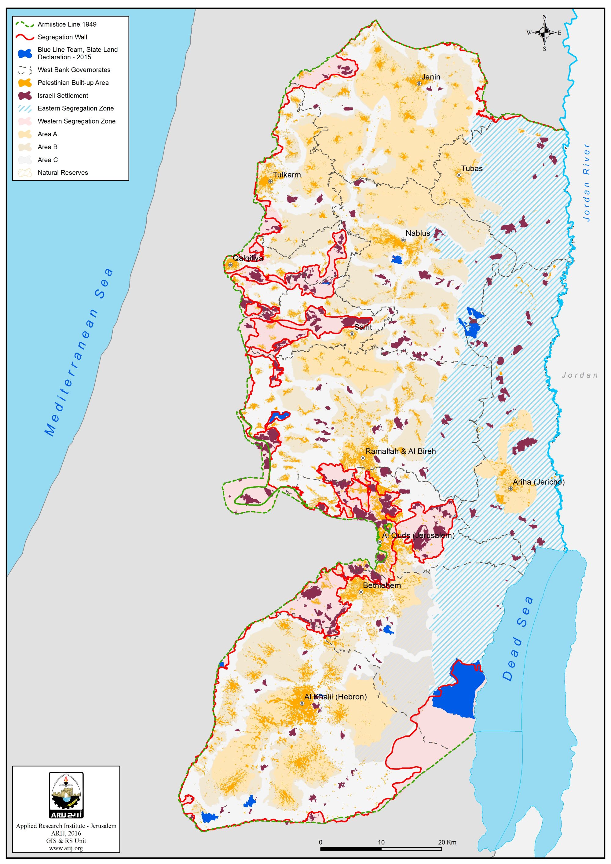
When Israel occupied the West Bank in 1967, only one third of the occupied West Bank territory was registered to the people with a Turkish (Ottoman Empire) issued Tabo (certificate of ownership) and/ or with an official British certificate/ registration issued during the British Mandate era. Fundamentally, the Ottoman land code (law) of 1858 continue to govern the land holdings in the West Bank but was never so used during the centuries of Ottoman rule, or under the British and Jordanian rules who maintained the same law. Israeli Military Order #59 (1967(amended by M.O.1091)), which constituted an abuse of the Ottoman land law, by which the Israeli Military-appointed position of 'Custodian of Government Property' expropriated land owned by the Jordanian Government. Also, allows the 'Custodian of Government Property' to expropriate land from individuals or groups by declaring it 'Public Land' or 'State Land', the latter which it defines as land that was owned or managed by, or had a partner who was an enemy body or citizen of an enemy country during the 1967 war.
Accordingly, when Israel occupied the West Bank territory it assumed control of what was assigned as State Land at the time – during the Jordanian Administration period; an area of 634,920 dunums (11.2% from the total West Bank area) classified as “Registered State Lands”, where according to the Israeli equivocal interpretation to the laws, Israel consider itself the legitimate heir of the Jordanian, the British Mandate, the Ottoman; respectively State Land after its military occupation to the Palestinian territory in June 1967, which is absolutely erroneous.
Following the Israeli occupation of the West Bank in 1967, Israel proceeded to classify an additional “Declared State Land” area of 843,922 dunums (14.9% from the total West Bank area) the high point of which was after the year 1979. Currently, the ICA prepares to complete procedures on what is called “Surveyed State Lands” which constitutes 11.7% from the West Bank with a total area of 666,327 dunums. In compilation, the total area of what classify State Land according to Israel as a “State Lands” rounds up to 2,145,169 dunums; some 38% of the West Bank total area).
It is worth mentioning that 248,904 dunums (4.4% of the West Bank area) and 11.6% of what constitutes state land according to Israel is actually located within what classifies as areas “A” and “B” according to Oslo II Interim Agreement signed between Israel and the Palestinian Liberation of Palestine (PLO), mainly in Hebron Governorate at the southern part of the West Bank.
The State Land Hersey
As a matter of fact , and from the first day of its occupation of the Palestinian land, Israel embarked to enactment of illegal and ambiguous laws in an attempt to legitimize its forcibly capturing the Palestinian lands in a deceptive democratic manner, while the fact is quite the opposite. Actually, Israel moved steadily toward various types of confiscations to serve its colonial interests where the main types of land expropriation were as follows: Confiscation by declaring “State Land” using the ottoman land classifications (Waqf Mulk, Khuraj, Matrouk, Mawat, Miri lands), confiscation by declaring Abandoned land (not cultivated), confiscation by declaring military zones and for military purposes, confiscation for closed areas, confiscation for public use and confiscation by Absentee Property law of 1950 and its amendments.
Without doubt, the intents behind the Israeli confiscations of the Palestinian lands throughout the years of occupation are not more than innovative tools to capture as much as possible from the Palestinian lands to sustain the Israeli Occupation where most of the lands confiscated as “state land” were allocated to the Israeli settlers and to the Israeli colonial enterprise on the Palestinian Territory and the examples are many: The settlement of Kiryat Arba’ in Hebron was built on lands expropriated as for military purposes and the settlement of Har Homa was built on a lands owned by residents from Bethlehem and Beit Sahour cities and confiscated in the year 1990 for “public use” by the former Israeli Finance minister (Isaac Mode’i) where these lands were classified as green areas before being confiscated. Another example is for the settlement of Ma’aleh Adumim where most of the lands that the settlement was built on, confiscated as “state lands” before they were allocated to build the settlement. Also Giva’ot military base located in Gust Etzion settlement bloc west of Bethlehem Governorate, the Israeli government had recently approved a plan to build a new settlement with 523 housing units in the military base site.
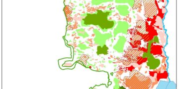
According to these aforementioned examples we can realize that the confiscations conducted by Israel throughout the years are not more than justifications to pounce on the Palestinian lands for the purpose of impose fait acompli, in a tools , the Israeli occupation authorities believes that it were legitimate. See the map 2 below:

Map 2: the “state land” areas in the West Bank according to the Israeli classification
Green Light for the Blue Line Team
As a matter of fact, the so-called blue line team, seems to be granted the green light by the political Bureau to rearrange the status of as much as possible from the Palestinian lands to be expatriated as state land as soon as possible. From the year 2013- May,31, 2016, the blue line team approved according to his alleged checks and examinations the confiscation of about 137, 000 dunums +95 % of which designated for the expansion of the illegal settlements in all parts of the oPt ( 27000 dunums in 2013- 40,000 dunums in 2014- 62,000 in 2015 and 8000 dunums until May 31, 2016).
133 % Prospective geographical inflation in Settlements’ Area
Not so far from the blue line team suspicious role to the interest of the Israeli settlement enterprise on the oPt, and in a geopolitical analysis conducted by the Geo-informatics Department at ARIJ …… an enormous inflation in the area of the Israeli settlements in the oPt to take place in the coming years as an outcome of the expropriation approvals adopted by the aforementioned team.
According to the aforementioned analysis, the total built up area of the illegal Israeli settlement in the oPt including East Jerusalem will jump from 196 km 2 (currently) to reach 457 km 2 in an inflation reach to 133 % within the coming few years.
More than that, and as a part of the Blue line team job, an illegal Israeli settlements will witness a leap in its geographical area ,where the area of many settlements will extended to reach %1000.
Currently , the blue line team is working to approve the expropriation of 260,871 dunums of lands located in and around 107 settlements in 9 Palestinian Governorates (99 settlement- 5 outposts – two stone quarries and one firing zone).
If we take a random examples for the lands that in the approving process to be declared as state land, we can find that Barqan settlement/Salfit will expand %258, Ariel %211, Giva’ot/Bethlehem %1154 Itamar/Nablus %162, Kalya/Jordan Valley %1088, Karme’el/Hebron % 586, Ma’aleh Adumim % 609 , Ma’aleh Shomron/Qalqiliya %296, Kedar/East Jerusalem %1330 and Beit Arieh/Ramallah %580.
The Alleged Firing Zones …..another 1 million dunums looted
On December 9, 2014, the Israeli daily newspaper “Haaretz” published a report indicated that the so-called Israeli Civil Administration (ICA), a vital branch of the Israeli occupation Army (allocated 35,000 dunums from the Palestinian lands declared by for the Israeli Army as fire zones for the interest of Israeli illegal settlements and outposts expansion in the West Bank. The targeted lands are located mostly in the Jordan Valley area, and south of Hebron Governorate nearby the illegal settlement of Ma’on and in the northwestern part of the West Bank in Salfit Governorate for the interest of Beit Arye, Peduel, Eli Zahav and ‘Ofra settlements.
The total area classified as a firing zone amount to 998,185 dunums and constitutes 17.6 % of the West Bank total area and nearly the same area classified as area “A” and falls under the control of the Palestinian Authority where some 70% of the Palestinians in the West Bank live.
The targeted lands were originally designated as State Land and turned over to the Army’s use as a firing and practice areas following the Israeli occupation and early 1970’s. However, and following the lunch of negotiations in the early 1990’s the Israeli Army disused much of the firing zones areas that it became abandoned but remains under full control of the Israeli Army
In 1999, the ICA employed an internal unit known as the “Blue Line Team” to identify and reconfirm the boundaries of areas identified as State Land using advanced digital methods and so far they completed charting some 260,000 dunums, of which 35,000 dunums located within the firing zones declared area. See table 2 below:
|
Table 2: Details for the locations and related information for the firing zones area in the oPt |
|||||
|
No. |
Firing Zone Code Name |
No. of Pal. Localities located within F.Z |
No. of Settlements Master Plan within F.Z |
Area of F.Z- Dunums |
Location |
|
1. |
203 |
11 |
2 |
32,591 |
Ramallah |
|
2. |
208 |
8 |
0 |
9,725 |
Ramallah |
|
3. |
309 |
3 |
0 |
8,263 |
Hebron |
|
4. |
900 |
4 |
1 |
73,077 |
J.Valley |
|
5. |
901 |
3 |
0 |
49,229 |
Tubas |
|
6. |
902 |
2 |
1 |
10,653 |
J.Valley |
|
7. |
903 |
3 |
4 |
80,309 |
J.Valley |
|
8. |
904 a |
5 |
4 |
4,2497 |
Nablus & J.V |
|
9. |
904 |
6 |
4 |
60,781 |
Nablus & J.V |
|
10. |
906 |
7 |
7 |
88,256 |
Ramallah & J.V |
|
11. |
911 |
2 |
1 |
6,819 |
J.Valley |
|
12. |
911 a |
2 |
0 |
4,632 |
J.Valley |
|
13. |
918 |
2 |
3 |
32,712 |
Hebron |
|
14. |
929 |
5 |
1 |
58,711 |
Ramallah |
|
15. |
929 a |
1 |
0 |
170 |
Hebron |
|
16. |
930 |
1 |
1 |
168 |
Hebron |
|
17. |
934 |
7 |
1 |
14,745 |
Ramallah |
|
18. |
959 |
1 |
0 |
76 |
Hebron |
|
19. |
aa |
10 |
13 |
409,294 |
Jerusalem & J.V |
|
20. |
aaa |
7 |
2 |
15,477 |
Ramallah |
|
TOTAL |
90 |
45 |
998,185 |
********* |
|
|
Table clarifies the details of the firing zone in the West Bank (ARIJ Database)
|
|||||
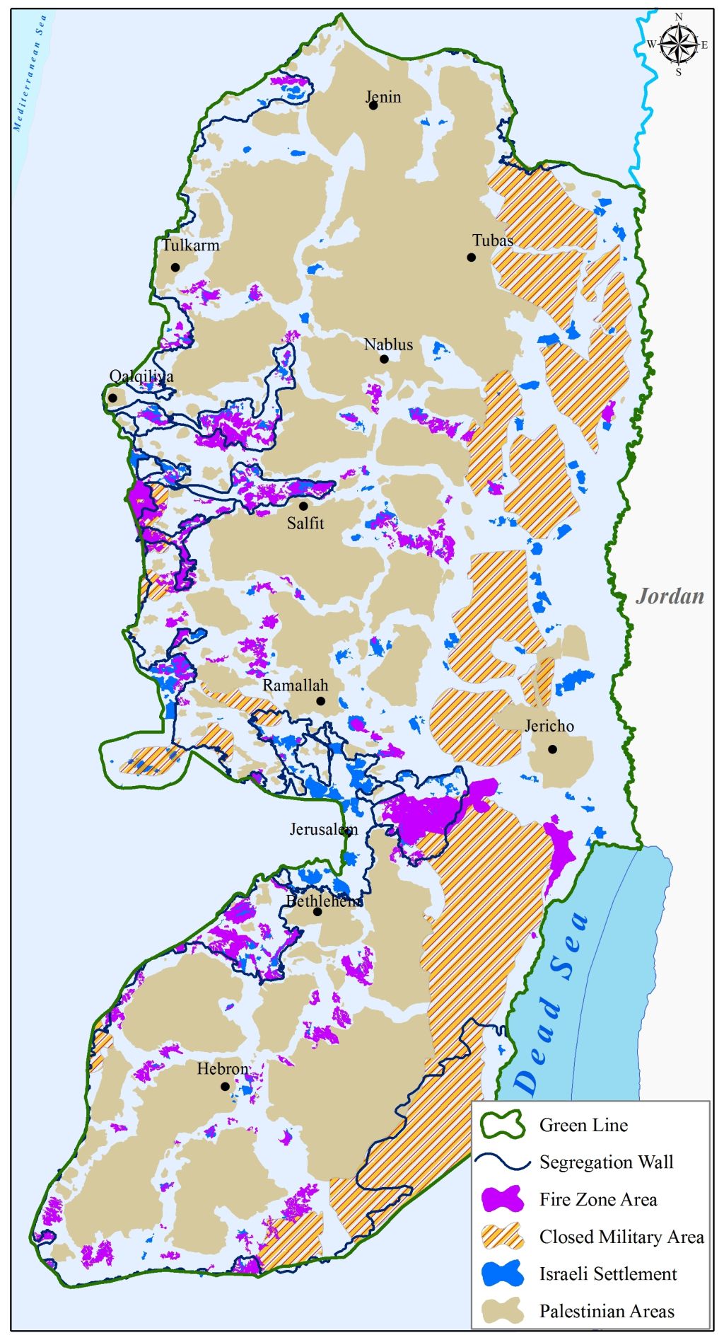
Map 3 : the firing Zones in the oPt
Legal & International Status
As a matter of fact, the Israeli seizing of the Palestinian lands under any of the pretext mentioned before, is a systematic Israeli circumvent over the international law rules and international legitimacy resolutions, where all of the confiscation orders issued by Israel are illegitimate and contradicts with the United Nation Security council Resolutions 242 and 338 that stipulate the illegality of the Israeli military occupation of the Palestinian lands and that includes all the confiscations, building illegal settlements and outposts and bypass roads, constructing the Segregation Wall, destroying Palestinian properties and restricting their movement and all of the colonial practices conducted by Israel since June 4, 1967-present are illegal, null and void.
The International community must stand for its responsibility to obligate Israel to stop all of its expansionist and colonial projects in the Palestinian Territory, and to refrain from its attempts to legalize what is illegal, while instead of being innovative in confiscating the Palestinian properties, Israel must comply with the International law rules and conventions before the world would be an eyewitness for burying the peace process and two-state solution.
For the Occupying State of Israel, the equivocal international silence in front of the Israeli colonial and illegal violations in Palestinian territory constitute a green light for Israel to move forward with its colonial and expansionist plans which will lead the situation in the occupied territory and in the entire region to a dire consequences.
The Israeli confiscation and targeting of the Palestinian residents and their properties in all parts in the oPt are illegal and constitutes a grave breach of the International law rules and conventions:
- Article 2 in the Universal Declaration of Human Rights reads that: 'Everyone is entitled to all the rights and freedoms set forth in this Declaration, without distinction of any kind, such as race, color, sex, language, religion, political or other opinion, national or social origin, property, birth or other status. Furthermore, no distinction shall be made on the basis of the political, jurisdictional or international status of the country or territory to which a person belongs, whether it is independent, trust, non-self-governing or under any other limitation of sovereignty.'
- Article 3 states that 'everyone has the right to life, liberty and security of person'.
- Article 13 states also that '(1) everyone has the right to freedom of movement and residence within the borders of each state.'
- Article 25 states that '(1) Everyone has the right to a standard of living adequate for the health and well-being of himself and of his family, including food, clothing, housing and medical care and necessary social services, and the right to security in the event of unemployment, sickness, disability, widowhood, old age or other lack of livelihood in circumstances beyond his control.'
- According to the Fourth Geneva Convention of 1949, Israel, as an occupying power is prohibited to demolish Palestinian houses as stated in Article 53 of the Convention which states that: 'Any destruction by the Occupying Power of real or personal property belonging individually or collectively to private persons, or to the State, or to other public authorities, or to social or cooperative organizations, is prohibited, except where such destruction is rendered absolutely necessary by military operations.
- Moreover and according to article XXXI of the 1995 Oslo agreement, Israel,is forbidden from building or planning to any project or settlements or any colonial expansion or any plan that lead to change the status of the West Bank and Gaza Strip. The article provides 'Neither side shall initiate or take any step that will change the status of the West Bank and the Gaza Strip pending the outcome of the permanent status negotiations'.
- Also the International Convention on the Elimination of All Forms of Racial Discrimination (1965), Article 5provides that: 'States' Parties undertake to prohibit and eliminate racial discrimination in all of its forms and to guarantee the right of everyone, without distinction as to race, color, or national or ethnic origin, to equality before the law, notably in the enjoyment of the following rights: … (e) in particular … (iii) the right to housing'.
- The Universal Declaration of Human Rights adopted and proclaimed by General Assembly resolution 217 A (III) of, December 10, 1948, Article 17 reads: 'No one shall be arbitrarily deprived of his property.' Which means it bans Israel from destroying or confiscating the property of the Palestinians at any case.
- Moreover Art. 23 of the Hague Convention of 1907also provides: In addition to the prohibitions provided by special Conventions, it is especially forbidden to destroy or seize the enemy's property, unless such destruction or seizure be imperatively demanded by the necessities of war.
[1] occupied Palestinian territory
Prepared By
The Applied Research Institute – Jerusalem
ARIJ