On the 3rd of May 2016, the Israeli Municipality of Jerusalem escorted by the Israeli Army, stormed Ein Al Juwaiza neighborhood, northeast of Al Walajeh village, west of Bethlehem city, and handed out administrative demolition orders for Palestinian owners of 8 houses in the village under the pretext of lacking building permits. See table 1 below:
|
Table 1 :Details for the targeted houses in Al-Walajeh |
||
|
Owners’ Name |
House/Structure Description |
Area- Square meter |
|
Mohammad Al-A’raj
|
Under construction house |
130 |
|
Sa’ed Al-A’raj
|
Under construction house |
140 |
|
Adham Abu Riziq
|
Under construction house |
130 |
|
Salim Abu Riziq
|
Under construction house |
150 |
|
Ahmad Abu Riziq
|
Under construction house |
160 |
|
Issam Abu At-tin |
Inhabited House |
150
|
|
Hassan Nasir Abu-At- tin
|
Under construction house |
150 |
|
Hassan Nasir Abu-At- tin
|
Residential barracks |
70 |
|
Source : Al-Walajeh Village Council |
||
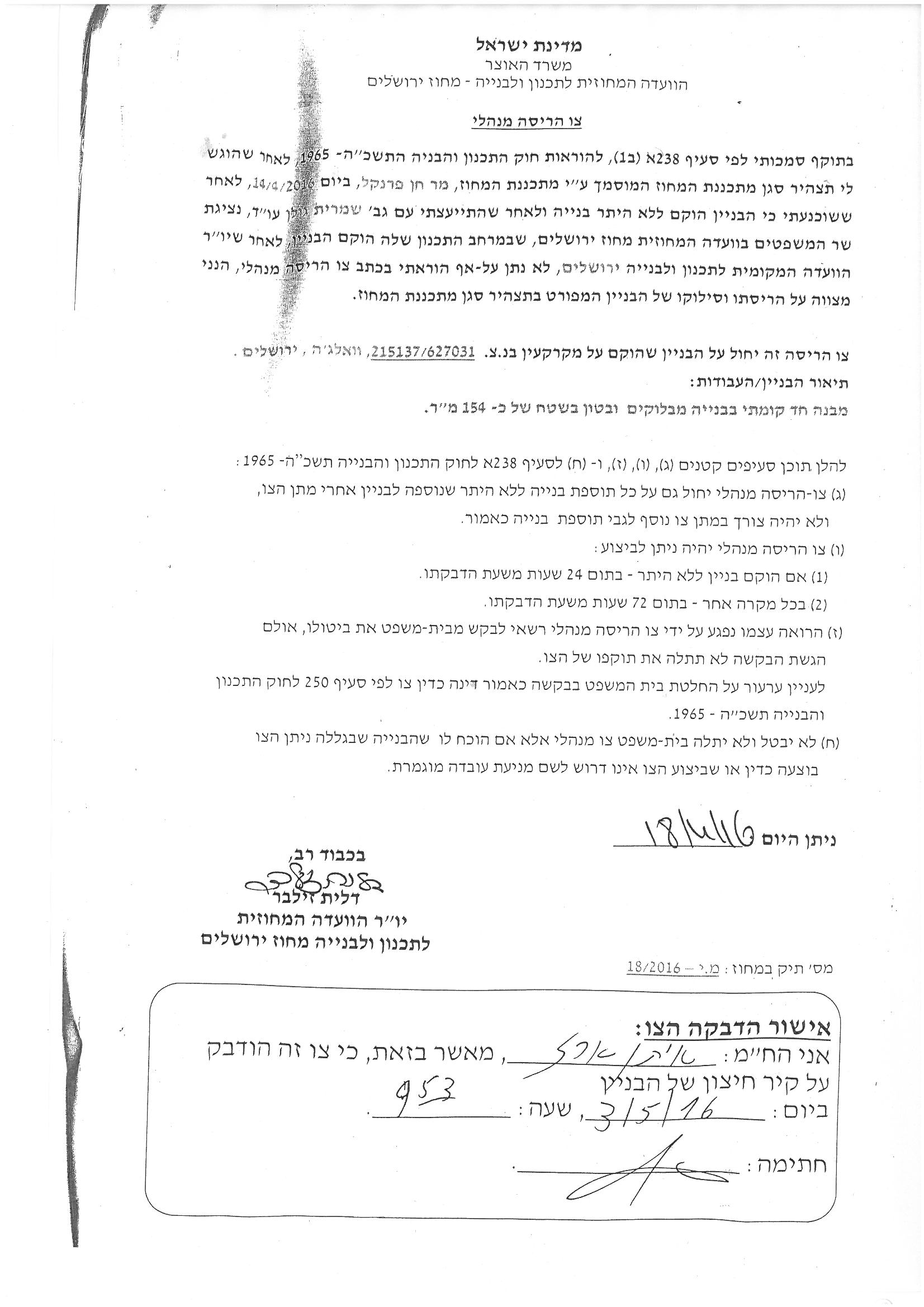
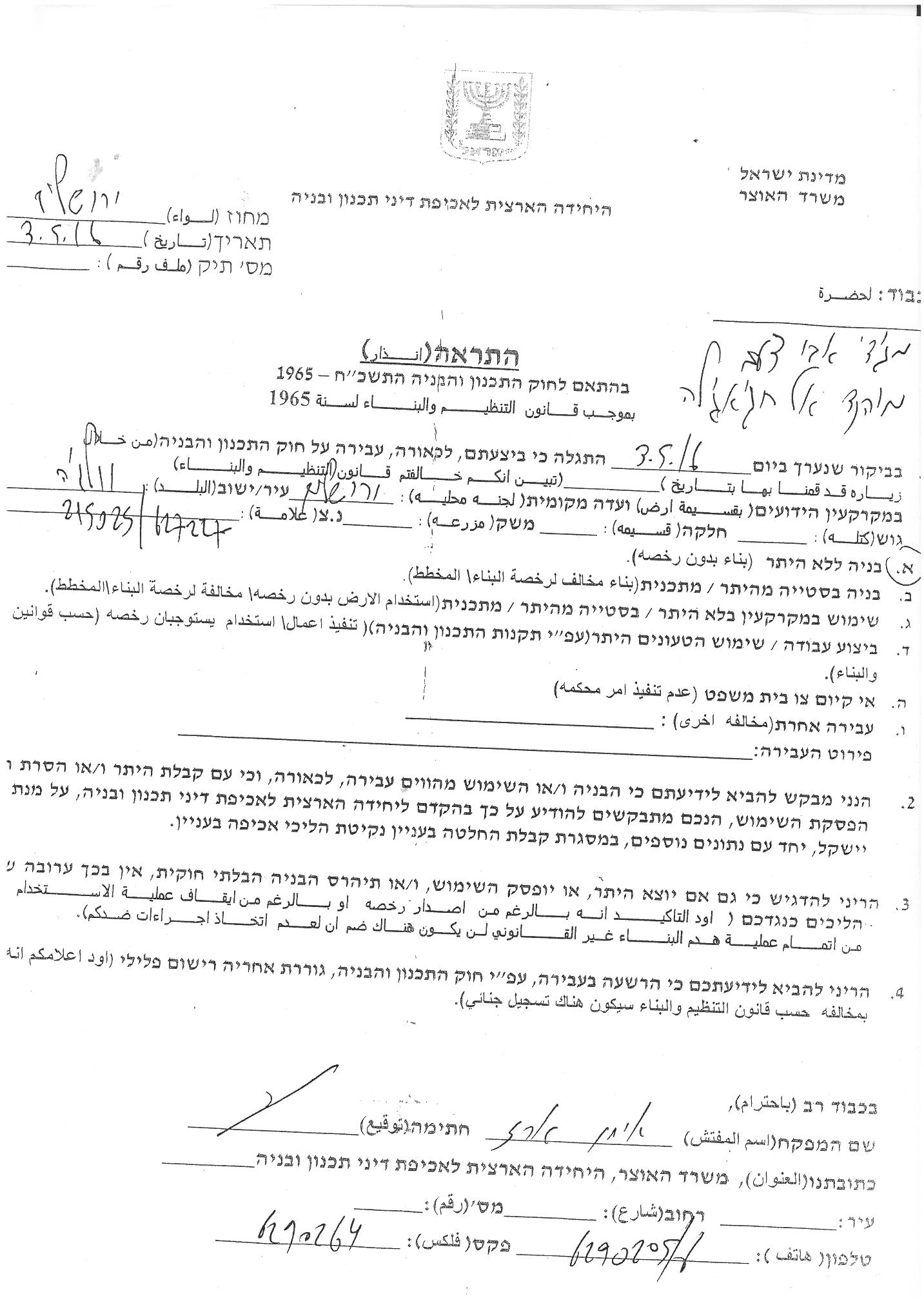
Two photos for the Demolition orders
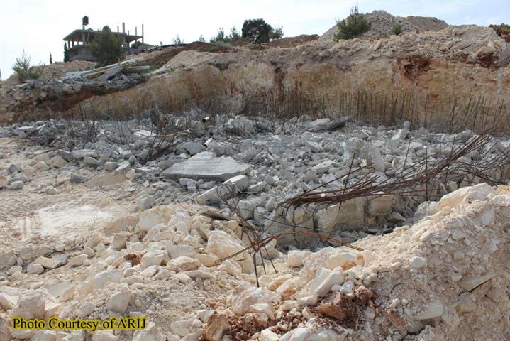
Few days later and on May 10 , 2016 , the Israeli bulldozers stationed in Ein Al-Juwaiza neighborhood in Al- Walajeh and demolished a house and an additional residential structure owned by the local resident Hasan Nasir Abu-At-Tin. It is worth pointed that Mr. Abu At-Tin was among those who received the administrative demolition order on May 3, 2016. See the pictures below :
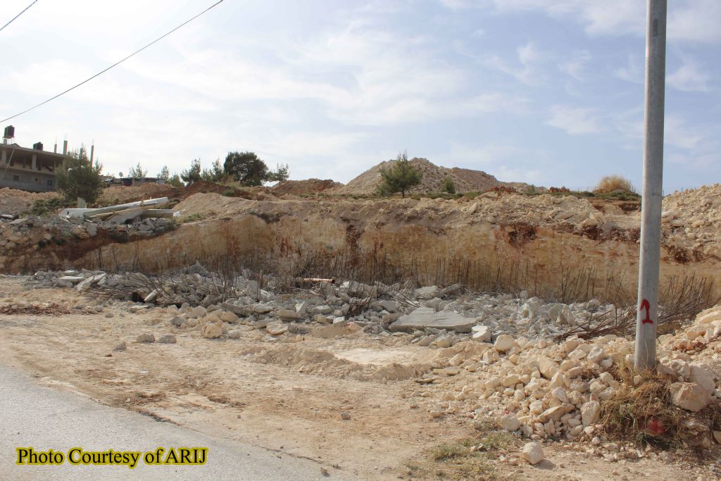

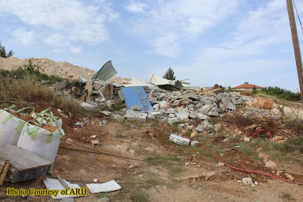
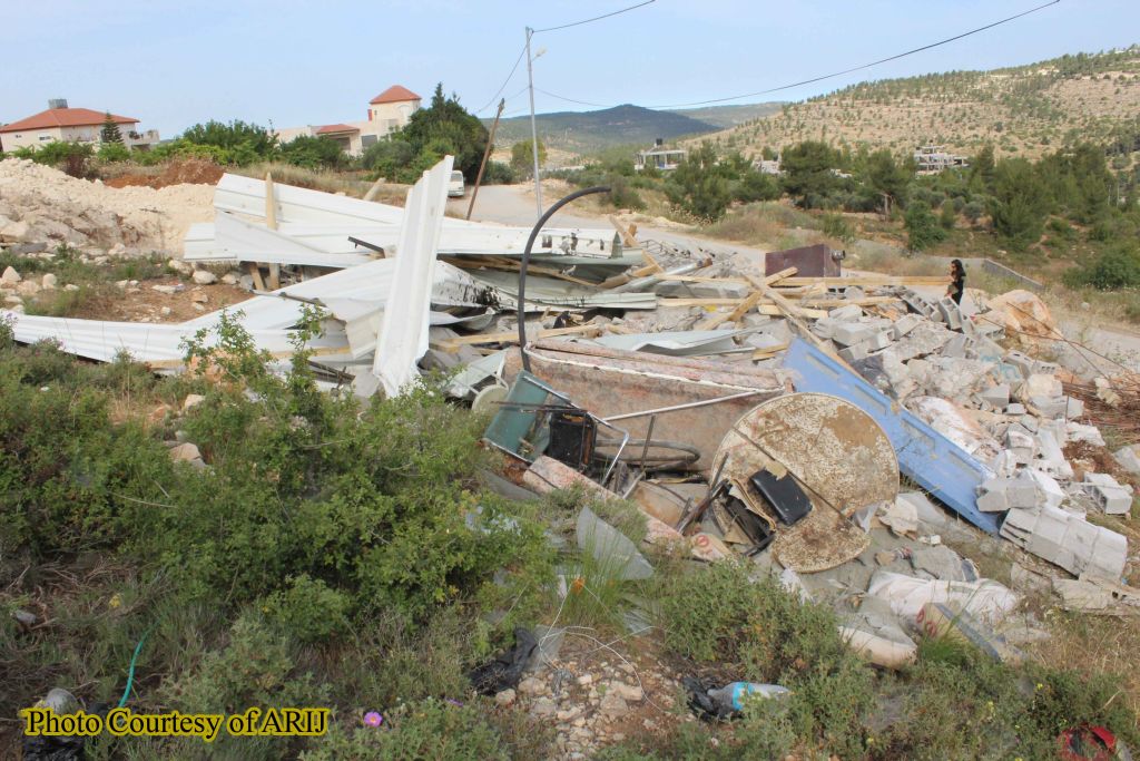
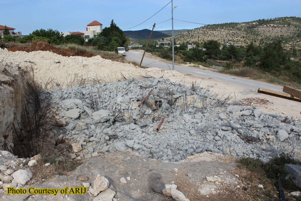
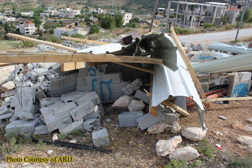
Photos captured by ARIJ fieldworkers for the house and the structure demolished in Ein Al-Juwaiza on the 10th of May
Latest Israeli targeting for Al-Walajeh village
During the year 2016, the Israeli Occupation Authorities targeted Al Walajeh village, west of Bethlehem city, with demolition orders and the demolition campaign.
Where on the 15th of March 2016, the Israeli Occupation Authorities handed out halt construction orders to 4 Palestinian houses in Ein Al Juwaiza neighborhood. https://poica.org/details.php?Article=9154
And on the 12th of April 2016, the Israeli Occupation bulldozers escorted by the Israeli Army invaded Ein Al Juwaiza neighborhood, northeast of Al Walajeh village, west of Bethlehem city, and demolished three Palestinian houses, under the claim of lacking valid building permits and notified forth other of final demolition under the same pretext.
https://poica.org/details.php?Article=9257
The Stricken Neighborhood of ‘Ein AL-Juwaiza
Ein Al Juwaiza neighborhood located in the northern part of the village of Al-Walajeh. The neighborhood was within the territories that unilaterally declared by Israel as “Jerusalem Municipal Boundary” right after the Israeli occupation of the Palestinian Territory on June 4, 1967.
Thenceforth , and since Ein Al-Juwaiza administratively become what is so-called “Jerusalem Boundaries” , the Palestinian residents of Ein Al-Juwaiza obligated to submit to the “Israeli Municipality of Jerusalem” for issuing building permits for their houses where their requests most often rejected. For the Israeli authorities the annexation of Ein al Juwaiza to the “Municipal boundary” restricted on the territories without the people living on these lands. Accordingly all of the residents of En Al-Jwaiza deprived from holding the so-called “Jerusalem IDs” and therefore their existence as well as their houses on their own lands in Ein Al-Jwaiza are illegal according to the Israeli Occupations authorities discrimination laws and regulations.
Al -Walajeh is a small Palestinian village located about 4 kilometers to the northwest of Bethlehem city and 8.5 kmto the southwest of the city of Jerusalem. The village houses a population of approximately 2,373 residents (PCBS Population Projections -2013). It is bordered by Battir and Husan villages from the southwest, by Sharafat village and Gilo settlement (established in 1971) from the east and by Har Gilo settlement (established in 1972) from the southeast, and the rest of the village is loop by the Israeli bypass road # 60.
It is worth mentioning that Al Walajeh Before the 1948 war, was spread over an area of 17.8 km2 and its boundaries extended westwards beyond the Armistice Line (the Green Line), and after the 1948 war, the village lost 75% of its lands and came to spread only over a total land of 4.4 km2 (24.8 % of its original area).
Following the Israeli occupation of the Palestinian lands in the year 1967, Israel unilaterally declared a new municipal boundary for the city of Jerusalem, where it expanded from 6.5 km² to 71 km² to include lands from nearby villages, these lands where then annexed to the state of Israel. Part of Al Walajeh village, in particular Ein Juwaiza neighborhood which has an area of 2.1 km2 was included within this annexed land.
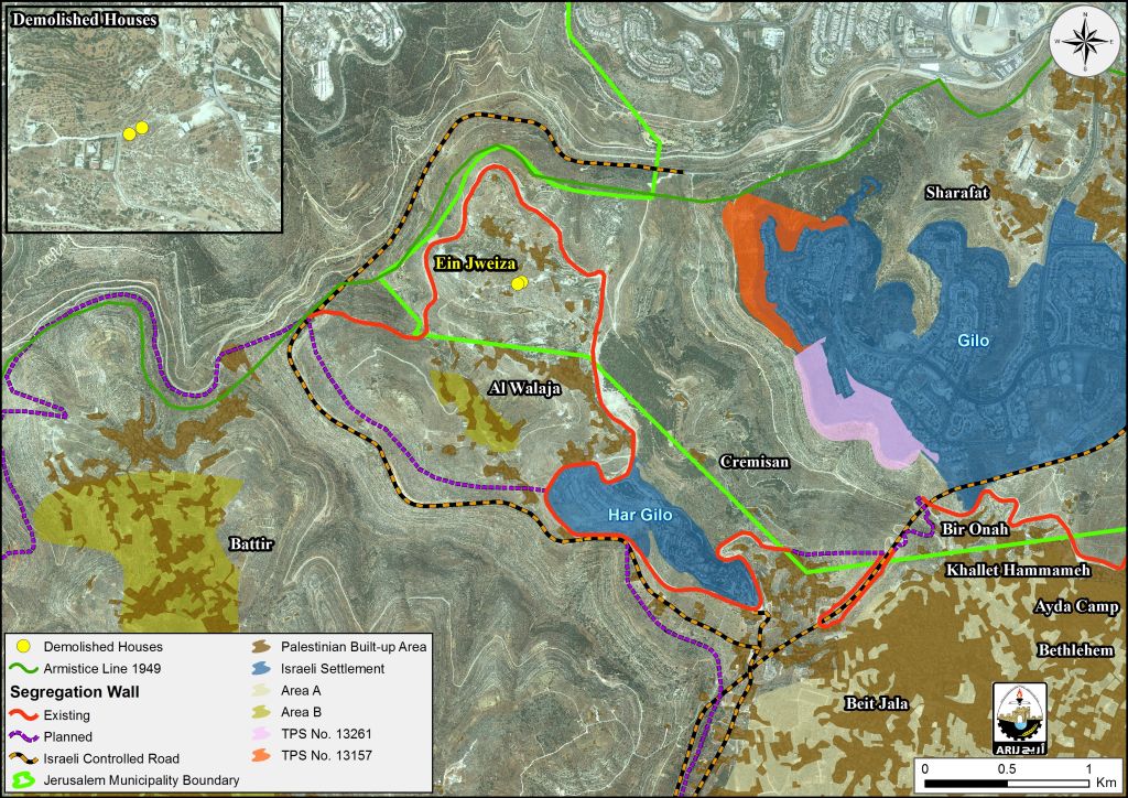
The Segregation Wall in Al Walajeh Village
According to the updated Wall plan of April 30, 2007, the Wall will place Al-Walajeh village in an isolated enclave, sealed off from all directions, east, west, north and south and from the neighboring Palestinian communities; Battier, Hussan, Beit Jala and from Bethlehem city center. The Wall, according to the map, was shifted northwards to include the neighborhood of 'Ein Al Juwaiza on the Palestinian side of the Wall, but sealed off the village completely from its southern part with a 2.5 km long Wall that will run alongside bypass road number 436.
In total, the Israeli Segregation Wall plan will extend for 7.9 km on the lands of Al-Walajeh, of which 3.5 km will be barbed wires. The Wall will isolate a total sum of 2210 dunums of the village's lands that is 50.2 % of the total village area. The road protection strip (the road security buffer zone) will cause the isolation of an additional 1100 dunums of lands from Al-Walajeh village, where these lands will fall south of the Wall and will be inaccessible to the Palestinian residents. Currently, 1.2 km of concrete wall exists around the village, 1.2 km is under construction and 5.5 km are in planning phase to be constructed around the village before the end of 2013.
Geopolitical Classification of Al-Walajeh lands
According to Oslo Interim Agreement, signed in September 1995, between the Palestinian National Authority and the Israeli government, Al Walajeh lands were classified into areas B and C; 113 dunums (2.6 percent of the total area of the village) of which were classified as area B, in which public order falls under the Palestinian National Authority's responsibility, where Israeli has full control over security matters. As for the remaining part of Al Walajeh lands, 4215 dunums, (97.4%), were classified as area C, an area that is under full control of the Israeli government. Since Israeli has control of this land, Palestinians are prevented from construction or benefiting from this land in any way possible, unless they get permission, which is extremely difficult, from the Israeli civilian administration in Bethlehem. It is worth mentioning here that area C includes agricultural lands, open spaces and small parts of urban areas. See table 2 below:
|
Table 2 :Land Classification in Al-Walajeh according to Olso II Agreement of 1995 |
||
|
Land Classification |
Area- Dunums |
% from the total village area |
|
Area A |
0 |
0 |
|
Area B |
113 |
2.6 |
|
Area C |
4215 |
97.4 |
|
total |
4328 |
100 |
|
Source : ARIJ Database 2016 |
||
The Israeli Colonial Activities in al- Walajeh village
Al Walajeh is bordered by two Israeli settlements from the east; Gilo, and Har Gilo, the Israeli settlement of Har Gilo from the south, and the Green Line from the north. After the Israeli occupation of the West Bank and Gaza Strip in 1967, successive Palestinian Localities Study Bethlehem Governorate 17 Israeli governments pursued an aggressive policy of land confiscation for the construction of Israeli settlements, military bases, and bypass roads to link the settlements to each other. Al Walajeh, like other Palestinian villages and towns, lost part of its lands, around 137 dunums (3.2 percent of the total area of the village) for the construction of the Israeli settlements of Gilo, and Har Gilo. See table 3 below:
|
Table 3 :Illegal Israeli Settlements built on Al-Walajeh land |
|||
|
Settlement |
Year of Establishment |
Population |
Area- Dunums |
|
Gilo |
1970 |
27,173 |
2,737 |
|
Har Gilo |
1971 |
462 |
414 |
|
Total |
***** |
27,635 |
3,151 |
|
Source : ARIJ Database 2016 |
|||
Moreover the Israeli bypass road number 436 extends for 2.5km on Al Walajeh southern part; isolating 713 dunums of Area A.
Al Walajeh Proposed Crossing
In February 9, 2006, the Israeli Occupation Army issued a new military order # (06/25/T) to confiscate 39.8 dunums from Al Walajeh village and Beit Jala city. The order identified the reason for the confiscation as “military purposes,” which was later defined for the construction of a new crossing in the area, (Har Gilo Crossing). The crossing aims to control movement of Al Walajeh residents between their village and services in Bethlehem Governorate and beyond. The military order comes in parallel with the Israeli Segregation Wall plan, which is set to encircle Al Walajeh. Residents of the village will only have this crossing to move in and out of their village, which will be under the Israeli Army’s control, virtually making the residents prisoners in their own village.
The Planned Settlement of “Giv’at Yael”
Giva’t Yael Settlement In June 2004, the Israeli authorities announced the construction of a new settlement (Giva’t Yael) in Al Walajeh village. The plan is to build this settlement on an area of 2000 dunums of the Palestinian land in Bethlehem governorate that will include more than 13,200 residential units and will accommodate 55,000 Israeli settlers. The construction of this settlement will complete the cycle of Israeli settlements, which separates the city of Jerusalem from other Palestinian cities and surrounds Bethlehem Governorate with Israeli settlements from all sides; starting from Har Homa in the north-east, till Gilo and Har Gilo in the north, towards Giva’t Yael settlement, which is planned to be constructed in the north-west, and ending with Gosh Etzion settlements, south of the Governorate.
“Refaim park”…another land swallowing in al-Walajeh
On July 7, 2013, the District Planning and Building Committee related to the Israeli Ministry of Interior approved the town plan No. 12222 to build what is known as “Refaim Metropolitan Park” in the southern parts of the city of Jerusalem. According to the plan that developed by the Israeli Municipality of Jerusalem and what is so-called “Israeli Development Authority”, Refaim Valley Park will occupy an area of 5,700 dunums, of which, 1850 dunums beyond the Green Line (Armistice Line of 1949) on lands belonging to t Al-Walajeh village residents (1200 dunums), while the remaining areas owned by the residents of the nearby town of Battir.
It’s worth pointed that Refaim Park is part of three large metropolitan “parks and green areas” being developed by the Israeli Municipality of Jerusalem and the Jerusalem Development Authority. Two of these parks, Arazim and Motza, are entirely within the Green Line in the western parts of the city Jerusalem.
The plan designates the area for forestation, preservation, recreation and light service facilities. Unlike the string of parks located around the Old City, this area does not resonate with religious historical and cultural sites, and the primary motivation behind it is genuinely environmental.
Moreover Refaim Park will be linked with the Arazim and Motza Parks by a 42 km bicycle path and hiking routes. Additionally an extreme sport center, horse riding center, water park, outdoor education center, sport fields, picnic areas, and arboretum will be created in the park system, with a NIS 250 million endeavor funded by the Israeli Municipality of Jerusalem, Israeli Prime Minister’s Office, Jerusalem Development Authority, and Ministry of Environmental Protection.
As a matter of fact, all al-Walajeh private lands, that lie between the Green Line and the Segregation Wall encircling the village of al-Walajeh, would be under the authority of the Israel Nature and Parks Authority, and even more the proposed park occupies all of the open and public spaces between the expanding settlements on the southern parts of the city of Jerusalem while erasing the Green Line and de facto shaping a buffer zone interrupts the geographical contiguity between Jerusalem and Bethlehem Governorate. See the map below:
Legal & International Status
The Israeli confiscation and targeting of the Palestinian residents and their properties in all parts in the oPt are illegal and constitutes a grave breach of the International law rules and conventions:
- Article 2 in the Universal Declaration of Human Rights reads that: 'Everyone is entitled to all the rights and freedoms set forth in this Declaration, without distinction of any kind, such as race, color, sex, language, religion, political or other opinion, national or social origin, property, birth or other status. Furthermore, no distinction shall be made on the basis of the political, jurisdictional or international status of the country or territory to which a person belongs, whether it is independent, trust, non-self-governing or under any other limitation of sovereignty.'
- Article 3 states that 'everyone has the right to life, liberty and security of person'.
- Article 13 states also that '(1) everyone has the right to freedom of movement and residence within the borders of each state.'
- Article 25 states that '(1) Everyone has the right to a standard of living adequate for the health and well-being of himself and of his family, including food, clothing, housing and medical care and necessary social services, and the right to security in the event of unemployment, sickness, disability, widowhood, old age or other lack of livelihood in circumstances beyond his control.'
- According to the Fourth Geneva Convention of 1949, Israel, as an occupying power is prohibited to demolish Palestinian houses as stated in Article 53 of the Convention which states that: 'Any destruction by the Occupying Power of real or personal property belonging individually or collectively to private persons, or to the State, or to other public authorities, or to social or cooperative organizations, is prohibited, except where such destruction is rendered absolutely necessary by military operations.
- Moreover and according to article XXXI of the 1995 Oslo agreement, Israel,is forbidden from building or planning to any project or settlements or any colonial expansion or any plan that lead to change the status of the West Bank and Gaza Strip. The article provides 'Neither side shall initiate or take any step that will change the status of the West Bank and the Gaza Strip pending the outcome of the permanent status negotiations'.
- Also the International Convention on the Elimination of All Forms of Racial Discrimination (1965), Article 5provides that: 'States' Parties undertake to prohibit and eliminate racial discrimination in all of its forms and to guarantee the right of everyone, without distinction as to race, color, or national or ethnic origin, to equality before the law, notably in the enjoyment of the following rights: … (e) in particular … (iii) the right to housing'.
- The Universal Declaration of Human Rights adopted and proclaimed by General Assembly resolution 217 A (III) of, December 10, 1948, Article 17 reads: 'No one shall be arbitrarily deprived of his property.' Which means it bans Israel from destroying or confiscating the property of the Palestinians at any case.
- Moreover Art. 23 of the Hague Convention of 1907also provides: In addition to the prohibitions provided by special Conventions, it is especially forbidden to destroy or seize the enemy's property, unless such destruction or seizure be imperatively demanded by the necessities of war.
Prepared by:
The Applied Research Institute – Jerusalem


