The Israel National News (ARUTZ 7) newspaper reported on the 2nd of March 2016, that the Israeli “Defense” minister, Moshe Ya’alon, has okayed the expansion of Hemdat Settlement in the Jordan Valley after a construction freeze of 19 years.
Hemdat was first established in 1979 on lands of Tubas city, in the Jordan valley area as a military site. Later on the 14th of February 1982, the Israeli Cabinet approved resolution No. 441 ‐‐ (HT/20) which stated the establishment of Hemdat Settlement in the Jordan valley[1] along with two other settlements in the occupied West Bank; thus, turning the military site into a residential settlement. Based on the resolution, the settlement of Hemdat to be comprised of 100 families.
Today, the settlement is bordered by Camp Asaf training base from the northwest, the Palestinian Kherbit Al Hadidiiyah and Roi’ settlement and from the west, and the Israeli bypass road No. 90 from the east.
Building in Hemdat settlement
Right after the establishment of the settlement was approved, an Israeli detailed Plan No. 304 was filed for building in the settlement and stated the construction of 108 housing units. Today, the settlement is home to more than 200 Israeli settlers (40 families) and occupy a total land area of 334 dunums.
According to the Israeli Jurisdiction classification of land, Hemdat settlement follows the so-called Biq'at Hayarden Regional Council. See Table 1
|
Table 1: Israeli Settlements following the so-called Biq'at Hayarden Regional Council |
|||||
|
No. |
Name |
Type of Urban Building |
Population |
Governorate |
Area (Dunums) |
|
1 |
Mevo'ot Yericho |
Outpost |
—- |
Jericho |
—– |
|
2 |
Yitav |
Settlement |
252 |
Jericho |
538 |
|
3 |
Beqa'ot |
Settlement |
178 |
Tubas |
2559 |
|
4 |
Gittit |
Settlement |
324 |
Nablus |
1188 |
|
5 |
Argaman |
Settlement |
185 |
Jericho |
1111 |
|
6 |
Gilgal |
Settlement |
191 |
Jericho |
1129 |
|
Settlement |
|||||
|
7 |
Hemdat |
Settlement |
196 |
Tubas |
334 |
|
8 |
Hamra |
Settlement |
184 |
Jericho |
1582 |
|
9 |
Yafit |
Settlement |
141 |
Jericho |
1578 |
|
10 |
Mechola |
Settlement |
436 |
Tubas |
1772 |
|
11 |
Tomer |
Settlement |
260 |
Jericho |
1134 |
|
12 |
Shdemot Mehola |
Settlement |
549 |
Tubas |
1237 |
|
13 |
Rotem |
Settlement |
131 |
Tubas |
72 |
|
14 |
Roi' |
Settlement |
167 |
Tubas |
1587 |
|
15 |
Petzael |
Settlement |
303 |
Jericho |
1448 |
|
16 |
Netiv Hagdud |
Settlement |
195 |
Jericho |
1274 |
|
Settlement |
|||||
|
17 |
Na'ama |
Settlement |
114 |
Jericho |
5125 |
|
18 |
Na'aran (Niran) |
Settlement |
71 |
Jericho |
445 |
|
19 |
Masu' |
Settlement |
191 |
Jericho |
2247 |
|
20 |
Maskiot |
Settlement |
612 |
Tubas |
433 |
|
21 |
Mekhora |
Settlement |
136 |
Nablus |
927 |
|
|
Total |
|
4816 |
|
27720 |
|
Source: Yesha Council – 2015 |
|||||
In 1991, the Israeli civil administration (ICA) operating in the occupied West Bank (oWB) designated master plans for Israeli settlements spread throughout the oWB, taking into consideration the allocation of additional land for the establishment of new settlements in the future and the expansion of the existing ones[2]. The master plans issued by the ICA in 1991 stood at 486.137 dunums of land (486.1 km², 8.6% of the total area of the WB), which is seven times the size of Israeli settlements area existed until the year 1991 which stood at 69,000 dunums of land (69 km², 1.2% of the total area of the WB).
Hemdat settlement master plan stands at 676 dunums of lands, twice the size of its current area, which is 334 dunums, and holds number 304/1, which actually shows the expansion to take place in Hemdat Settlement in the future. The plan designates more land for urban building, construction of roads and open spaces.
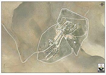
To the northwest of Hemdat settlement, there is an Israeli military base known as “Camp Asaf training base”. The camp occupies a total land area of 391 dunums. The master plan of Hemdat Settlement shows that Israel is trying to make a geographical contiguity between Hemdat settlement and the nearby Peles camp, so that in the future, both the settlement and the camp, might be joined together and become one entity. See Map 1

To conclude,
In recent years, there has been a significant increase in the area of Israeli settlements in the occupied West Bank and the Jordan valley as well; in return, there has also been an increase in the number of demolished homes and structures (water cisterns, solar panels, animal shelters, tents …etc), most notably, in the Jordan Valley area.
Palestinians across the occupied West Bank and in particular in the Jordan Valley area face discriminatory policies that restrict their development and their access to land; and this consequently affect their ability to build infrastructure to support themselves in the area. Note that while Palestinians in the Jordan Valley area can only use just five percent of the total land, Israeli settlers[3] account for 95% of land in the Jordan Valley.
[1] Secret Israeli Database Reveals Full Extent of Illegal Settlement. read more:
http://www.haaretz.com/secret-israeli-database-reveals-full-extent-of-illegal-settlement-1.266936
[2] Those settlements which exited until the year 1991, when the Israeli Civil Administration published the master plans.
[3] Israeli settlers living in 38 settlements in the Jordan Valley with a total population of +13,000.
Prepared by:
The Applied Research Institute – Jerusalem


