• About The Project
  • Palestine in Century
  • Selected Maps
  • Glossary
  • About ARIJ
  • About LRC
  • By Year
    • Case Studies By Year
    • Daily Report By Year
Friday, April 17, 2026
POICA
No Result
View All Result
  • Home
  • Settlements
    • New Israeli Settlements
    • Settlement Expansion
  • Israeli Violations
    • Agriculture
    • Confiscation
    • Demolition
    • Environment
    • Eviction of Palestinians
    • Settlers Attacks
  • Bypass Roads
  • Israeli Plans
  • Segregation
    • Checkpoints
    • Closure
    • Separation Plans
  • Military Orders
  • Reports
    • Daily Report
    • Monthly Report
    • Quarterly Report
No Result
View All Result
POICA
No Result
View All Result

The Israeli Occupation Forces threat Ain Al-Rash-ash hamlet of demolition

January 29, 2016
in Military Orders
The Israeli Occupation Forces threat Ain Al-Rash-ash hamlet of demolition


  • Violation: threat of demolition
  • Location:  southeast Duma village- Nablus
  • Date:  January 28, 2016
  • Perpetrators: Israeli Occupation Forces
  • Victims:  7 Bedouin families

Details:

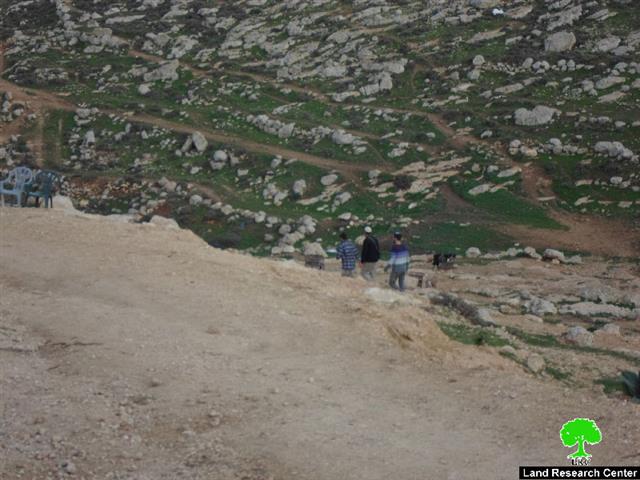
With no infrastructure and electricity, the Bedouins of Al-Kaa'bnah have been residing the area known as Ain Al-Rash-ash, south Nablus city for over 30years. Living in houses made by hey and metal slaps, most of Al-Kaa'bnah  Bedouins were born there developing a unique bondage with the land, valleys and mountains.

It should be marked that the area is located amidst three Israeli colonies namely (Kida, Yesh Kodish and Shilo). Not only, a military map is founded in the nearby, causing so much damage and changing facts on the ground.

On January 28, 2016 the Israeli Occupation Forces raided the community and verbally notified the residents of eviction within days on the claim that the area is "closed military zone"


Photo 1-6: view of the Bedouin community

It is indicated that the Israeli occupation authorities notified the residents of the community of eviction in 2014 on the claim of the area being "closed military zone".  Al-Kaa'bnah people objected to the order in Israel Supreme Court through a human rights organization on July 2014. The plea was rejected on 2015 and the area was declared "closed military zone".

The residents of the Bedouin community showed unprecedented resilience and steadfastness on their land despite all dangers and threats of the occupation. The following table shows information about the affected families due to the eviction order:

Affected citizen

Family

Minors

No. of sheep

Notified structure

Residential tent barrack (m2)

Sheep tent barrack (m2)

Suliman Al-Zawahrih

7

3

160

Two tents (45 +60)

Sheep tent(90) fodder barrack (12) and a barn(160)

Atta Al-Zawahrih

5

3

60

Tent (45)

Sa'd Al-Zawahrih

5

3

75

Tent (60)

Mahmoud Al-Zawahrih

3

1

23

Barrack (45)

Muneer Al-Kaa'bnah

9

3

144

Tent(90) +barrack (60)

Sheep barrack (40)

Wael Kaa'bnah

4

2

22

Barrack (45)

Sheep barrack (40)

Jasir Kaa'bnah

3

1

25

Barrack (45)

Sheep barrack (60)

Kayid Al-Zawahrih

11

4

42

Two tents (60+60)

Sheep barrack(60), sheep tent(60) and fodder storage unit (12)

Ali Al-Zawahrih

5

3

11

Tent (45)

Raed Al-Zawahrih

6

4

23

Barrack (45)

Dahish Al-Zawahrih

3

1

10

Barrack (45)


61

28

595

Eight tents + six barracks

4 sheep tents+ 2 barracks+ two fodder storage units


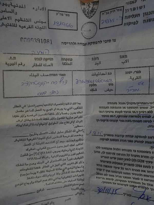
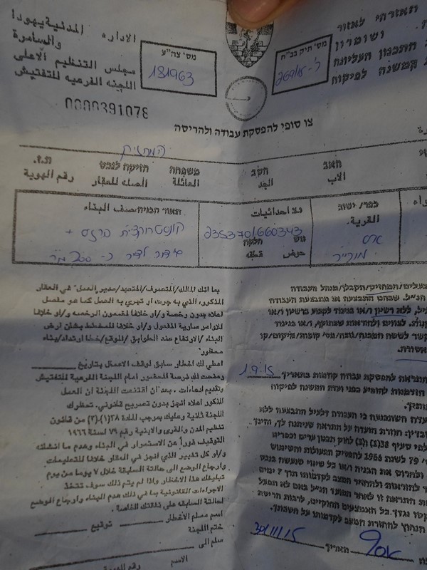
Copy of some of the military orders that were handed to residents of
Kherbit Ein Ar Rashash back in November 2015


Prepared by
 The Land Research Center
LRC
 

Recommended For You

INFOGRAPHIC: Mapping Control – Israeli Militray Orders across the occupied West Bank – 2025

by arij
April 16, 2026
0

    Prepared by:   The Applied Research Institute – Jerusalem

Read moreDetails

سلطات الاحتلال الإسرائيلي تستهدف قرية الجيب بأمر عسكري جديد

by arij
March 17, 2026
0
سلطات الاحتلال الإسرائيلي تستهدف قرية الجيب بأمر عسكري جديد

نشر المسؤول عن الأملاك الحكومية وأملاك الغائبين في الإدارة المدنية الإسرائيلية في الحادي عشر من شهر اذار من العام 2026 اعلاننا مفاده نية ما يسمى " المسؤول عن...

Read moreDetails

سلطات الاحتلال الإسرائيلي تستخدم الأوامر العسكرية لتعمق المشروع الاستيطاني في الضفة الغربية المحتلة

by arij
February 26, 2026
0
سلطات الاحتلال الإسرائيلي تستخدم الأوامر العسكرية لتعمق المشروع الاستيطاني في الضفة الغربية المحتلة

تقديم منذ احتلال الضفة الغربية عام 1967، اعتمدت سلطات الاحتلال الإسرائيلي منهجية واسعة عبر استخدام الأوامر العسكرية كأداة "قانونية" لفرض الوقائع الجغرافية والديموغرافية على الأرض الفلسطينية. وأصبحت هذه...

Read moreDetails

بين مطرقة الأوامر العسكرية وسندان التقييد الجغرافي, أوامر عسكرية إسرائيلية جديدة تطال أكثر من 1000 دونم في طوباس

by arij
November 26, 2025
0
بين مطرقة الأوامر العسكرية وسندان التقييد الجغرافي, أوامر عسكرية إسرائيلية جديدة تطال أكثر من 1000 دونم في طوباس

في الحادي والعشرين من شهر تشرين الأول لعام 2025، تسلّم أهالي محافظة طوباس سلسلة من الأوامر العسكرية الإسرائيلية التي استهدفت مساحات واسعة من الأراضي الفلسطينية في المحافظة. وقد...

Read moreDetails

“ما يزيد عن 25 ألف دونم من أراض الزيتون”,
موسم الزيتون في فلسطين تحت رهن الأوامر العسكرية

by arij
March 4, 2026
0

نشرت سلطات الاحتلال الإسرائيلي في الثاني والعشرين من شهر تشرين أول من العام 2025 مجموعة من الأوامر العسكرية والتي استهدفت مساحات شاسعة من الأراضي الفلسطينية في محافظات الضفة...

Read moreDetails
Next Post
الاحتلال الاسرائيلي يهدد بإزالة ” خربة عين الرشاش” جنوب شرق قرية دوما

الاحتلال الاسرائيلي يهدد بإزالة " خربة عين الرشاش" جنوب شرق قرية دوما

LATEST NEWS

التمدد الاستيطاني الإسرائيلي في الضفة الغربية المحتلة وأثره في تقويض مقومات الدولة الفلسطينية

التمدد الاستيطاني الإسرائيلي في الضفة الغربية المحتلة وأثره في تقويض مقومات الدولة الفلسطينية

by arij
April 16, 2026
0

........................................................

INFOGRAPHIC: ISRAELI SETTLER VIOLENCE IN 2025

by arij
April 16, 2026
0

........................................................

العدالة المؤجلة ورأي بلا تنفيذ: من قرار المحكمة إلى واقع الضم

أدوات غير مباشرة للاستيطان الإسرائيلي في مناطق (أ) و(ب) لإعادة تشكيل الجغرافيا والسيطرة في الضفة الغربية   

by arij
April 16, 2026
0

........................................................

INFOGRAPHIC: Palestinian Trees – Victims of the Israeli occupation Army & Settler Groups in 2025

by arij
April 16, 2026
0

........................................................

flag_yellow_lowEU-PfP-Logo

This website and its content were initiated in 1993 by the Applied Research Institute – Jerusalem (ARIJ) and the Land Research Center (LRC) with the support from the European Union up until 2023. Since then, the Applied Research Institute – Jerusalem (ARIJ) has taken over the continued development and maintenance of the website. The views expressed remain solely those of ARIJ) and do not necessarily reflect those of the European Union.

© 2026 Copyright | ARIJ | All Rights reserved.

No Result
View All Result
  • Home
  • Settlements
    • New Israeli Settlements
    • Settlement Expansion
  • Israeli Violations
    • Agriculture
    • Confiscation
    • Demolition
    • Environment
    • Eviction of Palestinians
    • Settlers Attacks
  • Bypass Roads
  • Israeli Plans
  • Segregation
    • Checkpoints
    • Closure
    • Separation Plans
  • Military Orders
  • Reports
    • Daily Report
    • Monthly Report
    • Quarterly Report

© 2026 Copyright | ARIJ | All Rights reserved.