Violation: cutting down 144 olive trees
Location: Wad Qana- Salfit
Date: 02/04/2015
Perpetrators: the Israeli occupation army
Victims: 4 agricultural families
Details:
Wad Qana is witnessing the most vicious of colonial plans that aims at emptying the area for the favor of a massive takeover and colonial expansion.
A massive force from the Israeli occupation army accompanied by a private vehicle on April 02, 2015 raided the areas of Al-Mayadin and Kaffit Abu Nasir and embarked on cutting down 114 olive trees aging 2 years. The recently planted trees are located to the northwest of Wad Qana village, which is adjacent to the colony of Karne Shamron. Not only that, the army troops looted the cut down trees and moved them to the aforementioned colony through trucks.
The stolen trees belong to farmer Ahmad Mansour (20 trees) Qasem Mansour (29 trees) Hasan Mansour (30 trees) and Ahmad Zaydan (35 trees).


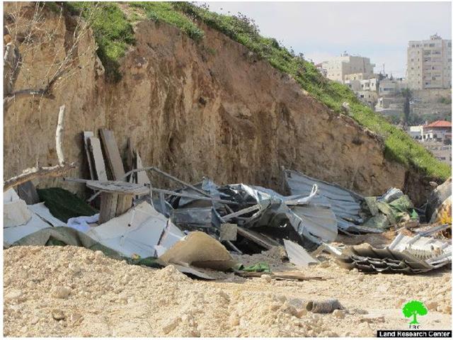
Photos 1-3: signs of the uprooting incident

Photo 4: a general photo of the targeted area

Photo 5: one of the affected owners
The Israeli occupation army justified this incident under the pretext of these trees being planted within what is claimed to be “natural reserve”. On March 2015, Israeli Nature Authority served the owners of those trees “eviction” orders on the trees, claiming them unlicensed.
Frequent attacks:
Farmer Qasem Mansour (61) is one of the most affected farmers from the Israeli occupation practices and violations; Mansour, over the past 10 years, got his trees uprooted several times and was arrested and threatened of murder. Despite all the attacks and assaults, farmer Qasem insists on planting his land to protect it from colonial expansion and takeover plans.
Wad Qana : claimed a natural reserve by Israeli occupation
Wadi Qana is surrounded by 7 Israeli colonies which devour lands and cause drastic damage to the environment. These colonies are Karne Shomron, Ginat Shomron, and Nov Uranium (north), Yakir and Nofim (south) and Emmanuel (east). The former colony dumps its wastewater into the valley which polluted the water springs of (al-Juza and al-Fawwar). The wastewater reached out the pools( watersheds) of al Bassa and al-Jamal. The colony of Maale Shomron that is located to the west of Wadi Qana is forming a imminent danger on the area which lands are shrinking and whose people are being displaced within a systematic plan undertaken by colonists so they be able to expropriate Palestinian properties. In addition, the outpost Nov Uranim which stands in the middle of the valley dumps its waste (solid and nonsolid) in the valley which severely damaged the environment (fauna and flora) and forced many Palestinian residents to evacuate.


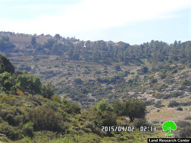
Photos 6 &7: Wadi Qana Nature Reserve
About Wad Qana:
It is located 10km to the northwestern part of Deir Istiya and surrounded by: Jinsafut, Kfar Laqif and Azzun from the east, and Kfar Thulth form the west. The valley overlooks "Yakir" colony from the southern side and is near to "Nofim" colony
Wad Qana is relative to the village of Deir Istiya (34,129 dunums) and has a total land area of 10,000 dunums, of which 13 dunums are built-up area. Worth mentioning, the place is planted with citrus, olives, and field crops.
The area is a natural slope that is located between two mountains and is famous for water abundance and soil fertility.
The lands of Deir Istiya are classified, according to Oslo accords as follows:
- Area B: it totals around 6132 dunums (18% of the village's total area)
- Area C : it totals around 27997 dunums (82% of the village's total area)
- Noteworthy, Wad Qana lands are all classified as area C.

Prepared by
The Land Research Center
LRC