• About The Project
  • Palestine in Century
  • Selected Maps
  • Glossary
  • About ARIJ
  • About LRC
  • By Year
    • Case Studies By Year
    • Daily Report By Year
Sunday, May 11, 2025
POICA
No Result
View All Result
  • Home
  • Settlements
    • New Israeli Settlements
    • Settlement Expansion
  • Israeli Violations
    • Agriculture
    • Confiscation
    • Demolition
    • Environment
    • Eviction of Palestinians
    • Settlers Attacks
  • Bypass Roads
  • Israeli Plans
  • Segregation
    • Checkpoints
    • Closure
    • Separation Plans
  • Military Orders
  • Reports
    • Daily Report
    • Monthly Report
    • Quarterly Report
No Result
View All Result
POICA
No Result
View All Result

Land Leveling in Kisan Village South of Bethlehem Governorate

March 10, 2015
in Confiscation
Land Leveling in Kisan Village South of Bethlehem Governorate


On March 8, 2015, the Israeli bulldozers accompanied with Israeli Army Forces stormed Kisan village southeast of Bethlehem Governorate and started to raze 80 dunums of Palestinian lands owned by local residents from the village.

 Israeli Army officers from the “Israeli Civil Administration” notified the owners of the targeted lands that their lands along with nearby (600 dunums of lands)  had been confiscated from the year 2004 under the pretext of “State Land”.

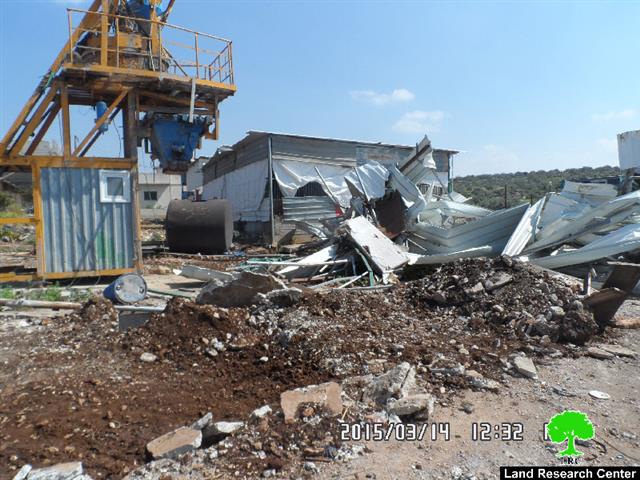
Industrial Zone in Kisan

ARIJ filed workers interviewed Mr. Hussein ‘Ali Ghazal the head of Qisan village council where he provided that the targeted 80 dunums piece of land that owned by local families from Kisan was targeted in the year 2004 with an Israeli order stating the expropriation of the lands under the pretext of “State Land”, while the owners submitted to the Israeli court that supposed to be considering the case until now.

Mr. Ghazal also added that the Israeli Army officers informed him that what is so-called “the Custodian of the State Property” and after confiscating the land (600 dunums), had sold a peace of 80 dunums for an Israeli settler from Gush Etzion settlement bloc for the purpose of building an Israeli industrial zone in the site! Among the owners of the targeted Palestinian lands were known :

  • Ayoub Youseph Mohammad Subeih
  • Mahmoud Youseph Mohammad Subeih
  • Mohammad Youseph Mohammad Subeih
  • Mousa Mohammad Awadallah Ebayyat
  • ‘Ali Mohammad Awadallah Ebayyat
  • Issa Mohammad Awadallah Ebayyat
  • Ahmad Mohammad Awadallah Ebayyat. See photos and maps below:-

   ​


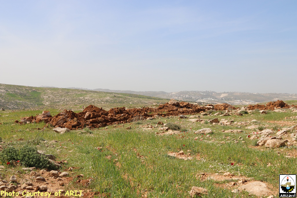
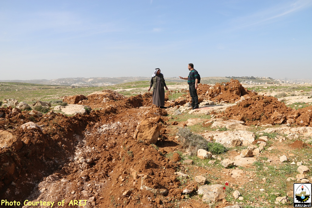
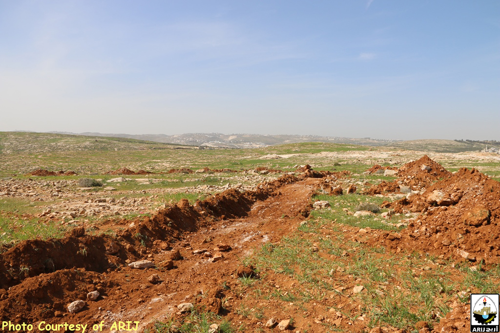
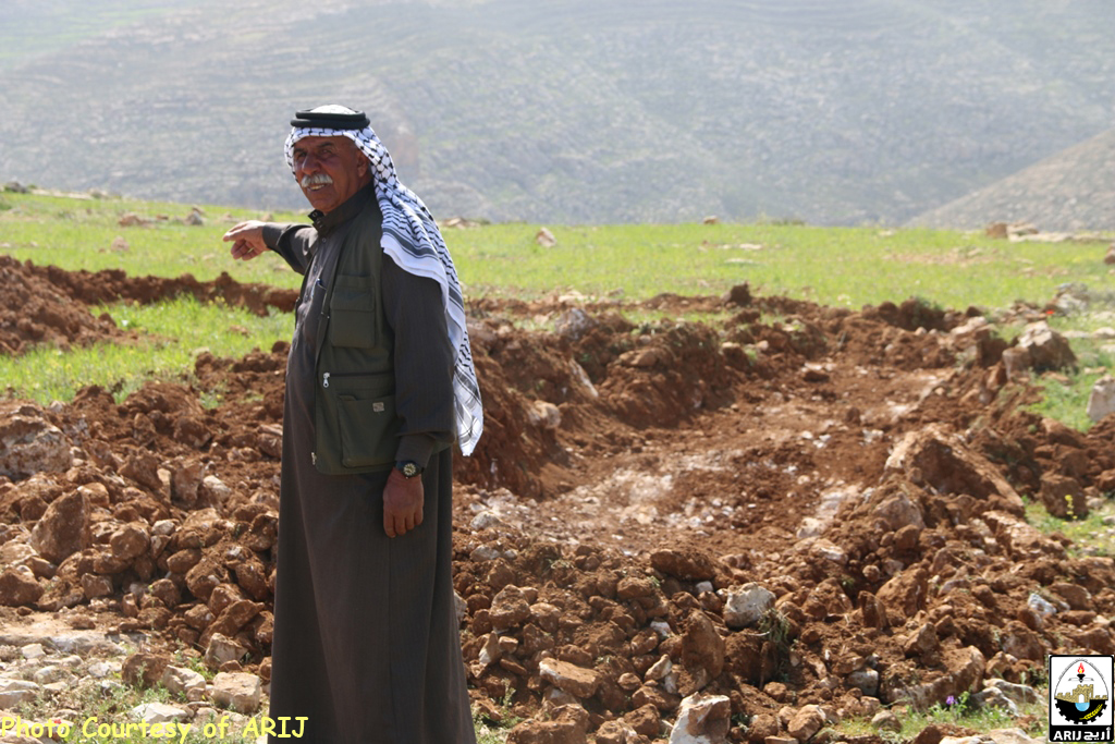
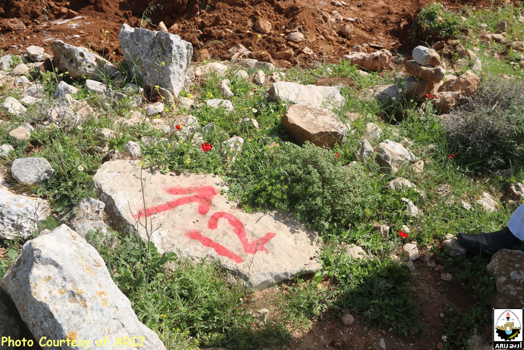
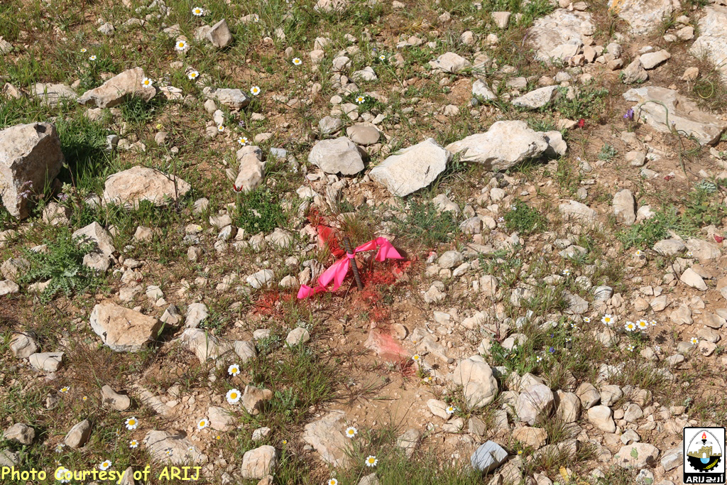
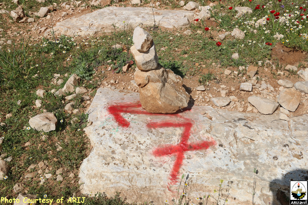
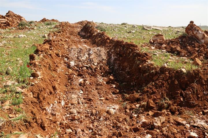
Photos captured b ARIJ field workers for the targeted lands in Kisan

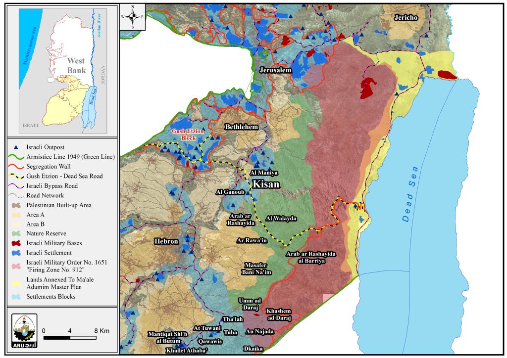
Map 1: targeted lands in Kisan village

Gush Etzion- Dead Sea………… Geopolitical Analysis

In a geopolitical analysis conducted by the (Settlement Monitoring Department –ARIJ) , the expropriation of the lands in Kisan village is part from a unilateral Israeli colonial plan to expand the illegal settlement bloc of Gush Etzion to reach the dead sea area.

Hence, the lands of Kisan constitute the corner stone to pave the way for the geographical linkage between Gutsh Etzion bloc to the Dead Sea area taking into consideration focal facts:-

  • Kisan village located in a strategic area the middle between Gush Etzion bloc and the Dead Sea Area.
  • Kisan village lands located adjacent to the what is known as “Nature Reserve Area” where the Palestinians deprived to enter their lands in these area.
  • Kisan village located on the road that linking Gush Etzion bloc with the dead Sea shores (noting that the Israeli Ministry of Transportation started few months ago to rehabilitate significant parts of the road to facilitate the Gush Etzion settlers to reach the Dead Sea shores).
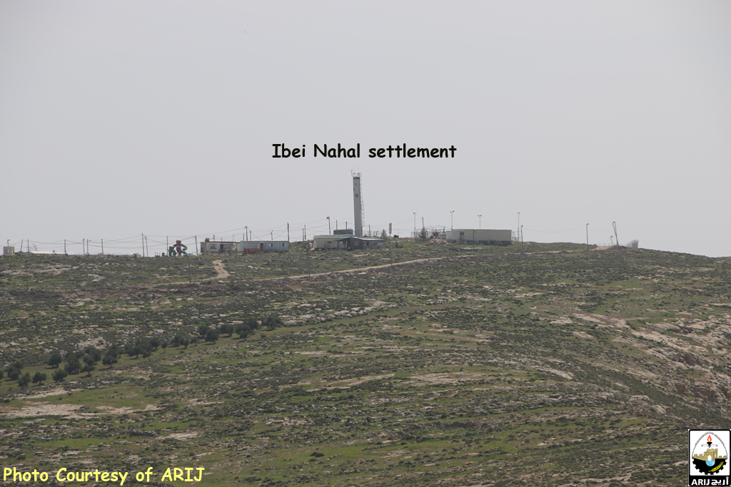
  • Kisan is the main urban community located adjacent to the natural reserve area , Ma’aleh ‘Amos, and Abi Nahal outposts via  the closed military zone 912 that extends to reach the Dead Sea shores.
  • If implemented , the proposed Industrial zone can be easily attached as a part of Gush Etzion bloc whereby the bloc would Reach the Dead Sea Shores.

 More than that, all of the Palestinian Bedouin communities located east and south from Kisan village via the Dead Sea, located in the Nature Reserve” area and the firing zone 912, in addition  to the (139,000 dunums expropriated in the year 2009 along the southern shores of the Dead sea) while all of these lands closed for their Palestinians owners.

Accordingly most of the lands located between Gush Etzion settlement bloc and the dead sea area  forcibly captured by the Israeli Occupation Authorities under several illegal pretexts, where the way paved for gush Etzion bloc to extend and reach to the Dead sea Shores. See map 2:


Kisan is a Palestinian village located southeast of Bethlehem Governorate. The village is bordered by Toque’ and Al-Menia village from the south, Ibei Nahal illegal settlement from the south, Umm Buttum village from the west and the illegal Israeli settlement of Ma’aleh ‘Amos (est. 1981, area 320 dunums) from the southeast, the Dead Sea shores from the east. The village total population is 557 residents (PCBS 2015 Projections).

According to Oslo Accords, 11% of Kisan is considered nature reserve while 40% is under Area B (PA is in charge of civil matters with Israel responsible for security). However, most of the village lands (49%) is under Area C (Israel maintains full security and administrative control).


Prepared by:  
The Applied Research Institute – Jerusalem

Recommended For You

هدم وسرقة بيت تعبئة زراعي في كردلة – ضربة موجعة للاقتصاد المحلي

by arij
January 21, 2025
0
Demolition and Theft of an Agricultural Packing Facility in Kardala: A Severe Blow to the Local Economy

تفاصيل الانتهاك: منذ احتلال الضفة الغربية عام 1967، باتت قرية كردلة هدفًا رئيسيًا للاحتلال الإسرائيلي الذي يسعى بكل الوسائل لتفريغها من سكانها الأصليين، تمهيدًا للاستيلاء على أراضيها ومواردها....

Read moreDetails

Demolition and Theft of an Agricultural Packing Facility in Kardala: A Severe Blow to the Local Economy

by arij
January 20, 2025
0
Demolition and Theft of an Agricultural Packing Facility in Kardala: A Severe Blow to the Local Economy

Since the occupation of the West Bank in 1967, the village of Kardala has become on the list of the prime and major targets for the Israeli occupation,...

Read moreDetails

تستهدف ما يزيد عن6900, تسجيل الأراضي في القدس في خدمة مشروع الاستيطان الإسرائيلي وشرعنة الاستيلاء على الأرض

by arij
May 8, 2023
0
POSITION PAPER: A Land Mine before the “Two State Solution

   تسوية الأراضي هي أحدى اهم حيل إسرائيل لتهويد القدس الشرقية، وقد كان القضاء الإسرائيلي قد أصدر إعلاناً عن بدء "تسوية أراضٍ" بمسميات وأرقام جديدة للأحواض في احياء...

Read moreDetails

الاحتلال يصادر محتويات منتزه في جبل السنداس جنوب مدينة الخليل

by arij
September 14, 2022
0
الاحتلال يصادر محتويات منتزه في جبل السنداس جنوب مدينة الخليل

  الانتهاك: مصادرة مواد منتزه. تاريخ الانتهاك: 31/08/2022. الموقع: جبل السنداس/ مدينة الخليل. الجهة المعتدية: الإدارة المدنية التابعة للإحتلال. الجهة المتضررة: المواطن يسري الجمل. التفاصيل: أقدمت سلطات الاحتلال...

Read moreDetails

The Occupation Confiscates Properties of a Park Owner at Hebron City

by arij
September 15, 2022
0
الاحتلال يصادر محتويات منتزه في جبل السنداس جنوب مدينة الخليل

  Violation: Confiscation of park properties. Date: August 31st 2022. Location: As-Sindas Mountain / Hebron city. Perpetrators: The Israeli Civil Administration. Victims: Citizen Yusri Aj-Jamal. Description: Wednesday ,...

Read moreDetails
Next Post
هدم مصنعاً لصناعة الطوب في قرية برطعة / محافظة جنين

هدم مصنعاً لصناعة الطوب في قرية برطعة / محافظة جنين

LATEST NEWS

الأراضي الفلسطينية بين الذرائع الأمنية والأطماع الاستيطانية – “الأمن، الآثار، والطبيعة كحجج لاقتلاع الفلسطينيين من أراضيهم”

by arij
April 15, 2025
0

........................................................

الطرق الالتفافية الاسرائيلية وأثرها على البيئة الفلسطينية

انتهاك للطبيعة والهوية في الأراضي الفلسطينية المحتلة

by arij
March 17, 2025
0

........................................................

Israel Advances Settlement Plan on Ancient Olive Groves on lands of Beit Jala city, Violating International Law and depriving Palestinians their lands

إسرائيل تمضي قدمًا في مخطط استيطاني جديد على أراضي مدينة بيت جالا، في انتهاك للقانون الدولي وحرمان الفلسطينيين من أراضيهم

by arij
April 29, 2025
0

........................................................

Israel Advances Settlement Plan on Ancient Olive Groves on lands of Beit Jala city, Violating International Law and depriving Palestinians their lands

Israel Advances Settlement Plan on Ancient Olive Groves on lands of Beit Jala city, Violating International Law and depriving Palestinians their lands

by arij
April 29, 2025
0

........................................................

flag_yellow_lowEU-PfP-Logo

This website has been produced with the assistance of the European Union. The contents of this publication are the sole responsibility of ARIJ & LRC and can in no way be taken to reflect the views of the European Union.

© 2025 Copyright ARIJ . All Rights reserved. .

No Result
View All Result
  • Home
  • Settlements
    • New Israeli Settlements
    • Settlement Expansion
  • Israeli Violations
    • Agriculture
    • Confiscation
    • Demolition
    • Environment
    • Eviction of Palestinians
    • Settlers Attacks
  • Bypass Roads
  • Israeli Plans
  • Segregation
    • Checkpoints
    • Closure
    • Separation Plans
  • Military Orders
  • Reports
    • Daily Report
    • Monthly Report
    • Quarterly Report

© 2025 Copyright ARIJ . All Rights reserved. .