Following his first visit to Israel and the occupied Palestinian Territory (oPt) since taking over the White House six years ago, the US President, Barack Obama, instructed the US Secretary of State, John Kerry, to bring back the Palestinians and the Israelis to the negotiations table. During the many visits of John Kerry to the Middle East, the Israelis and Palestinians have agreed to a nine-month timeline for final-status negotiations, to start on the 31st of July 2013 and end on the 29th of April 2014 under the auspices of the US administration.
Despite the resumption of peace negotiations between the Palestinians and the Israelis, and the U.S. pressure to halt Israeli settlement activities and violations on the ground, Israel’s violations against Palestinians did not stop for a moment. During the period of July 31st, 2013 and April 29, 2014 (the nine months negotiations period), Israel targeted Palestinian lands with various military orders stating the confiscation of these lands for the various military purposes; that is in addition to issuing military orders to demolish homes and structures. The Israeli Occupation authorities also carried out many demolitions which affected hundreds of Palestinian homes in the occupied Palestinian Governorates , including East Jerusalem.
The Israeli violations did not stop at this point, but Israeli settlers also committed hundreds of attacks on Palestinians and their property, in addition to religious and archaeological sites under the eyesight and protection of the Israeli occupation Army. Furthermore, the government of Israel didn’t halt the building and expansion of Israeli settlements in the occupied West Bank (including East Jerusalem), but stepped up its policies to issue plans and tenders to build thousands of housing units in Israeli settlements in the occupied territory. Following is a breakdown of the Israeli violations in the occupied Palestinian territory during the period of July 31st 2013 and April 30, 2014 :
Israeli “Land Confiscation orders”
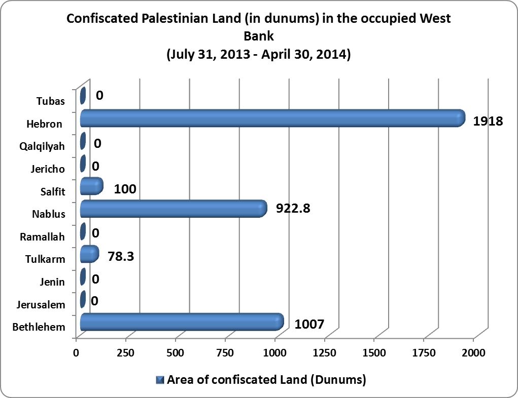
Since the beginning of the first direct negotiations between the Israelis and the Palestinians on the 31st of July 2013, the Israeli Occupation Authorities issued 12 military orders to confiscate land in the occupied West Bank. Over 4000 dunums of land targeted in the military order including: 1918 dunums in Hebron Governorate which comes in the first place in terms of targeted land, followed by Nablus Governorate where 922.8 dunums was targeted in the military orders. Note that Israel has used a number of methods to appropriate land, such as seizure of land for military purposes; declaring the area as state land and thus Palestinians have to evacuate; or confiscation of land for public needs.
Most of the lands targeted in Hebron Governorate are in the southern Hebron Hills, where Israel declared the confiscation of 1370 dunums of lands of Arab Al Ka’abnah in the eastern part of Yatta town. Israel has cited that the targeted land has been declared by the Israeli occupation authorities back in the 80’s as "firing zone", and though, the Palestinians are not entitled to use or benefit from the land in anyway, so it has to be confiscated. See Chart 1
Israeli Demolition Orders
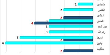
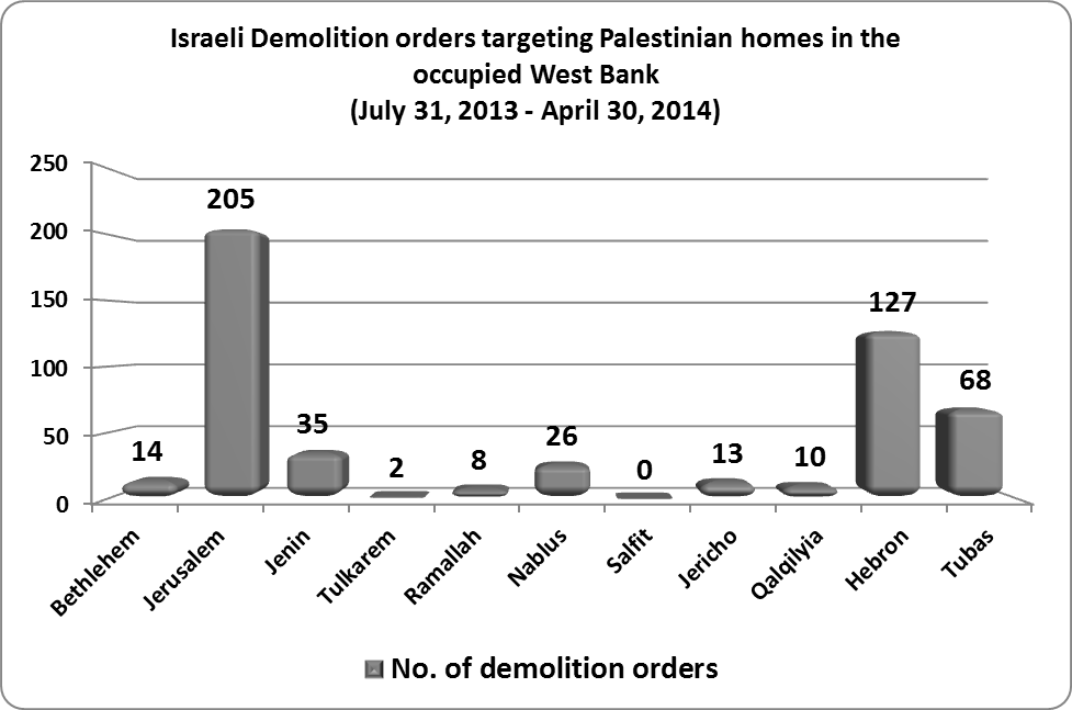
Since the convening of the first direct meeting between Israeli and Palestinian leaders in July 2013, 508 Israeli military orders were issued in the occupied West Bank to halt the construction of Palestinian homes under the pretext of un-licensing. Of the total threatened homes, 205 were targeted in occupied East Jerusalem, and 127 homes in Hebron Governorate. The increase in the number of demolition orders in East Jerusalem is due to several reasons, including that: (1) Jerusalem Governorate is the heart of the Israeli-Palestinian conflict; (2) the Israeli Judization plans in Jerusalem city aims at imposing realities on the demographic status of the city by increasing the number of Jews living in the city and reducing the number of Palestinians living in it, to become a city with Jewish majority and Palestinian minority. The demolitions carried out by the Israeli authorities in the occupied West Bank and in East Jerusalem in particular, are some of the most common means Israel uses to displace Palestinians and drive them out of the city. See Chart 2
The Demolition of Palestinian homes
In addition to the 508 military orders that targeted Palestinian homes in the occupied Palestinian Governorates, the Israeli occupation Authorities demolished 346 homes. Tubas Governorate has the highest number of demolished homes, where 175 homes were demolished since the beginning of the direct talks between the two sides (during July 31, 2013 and the 30t of April 2014), followed by Jerusalem Governorate where 89 homes were demolished. The increase in the number of homes demolished in Tubas Governorate is due to several reasons, including : (1) most of Tubas Governorate land was declared by Israel as “Closed Military Area”[1] back in the 1967 when Israel occupied the West Bank including East Jerusalem and the Gaza Strip. (2) Israel has also created a de facto Eastern Segregation Zone along the eastern terrains of the occupied West Bank Territory, of which, Tubas Governorate land is part of it. This action aimed at ceasing Palestinian urban development and economic development in that area. Additionally, Israel’s policy in the Eastern Segregation Zone aimed at displacing Palestinians from their place of residence, so that Israel could further implement its colonial plans in the area and strengthen its presence in the occupied Palestinian territory; See Chart 3
Like other demolition and land confiscation campaigns carried out by Israel in the occupied West Bank, Israel claims that Palestinian homes and structures are demolished because they lack proper building authorization from the Israeli occupation Authorities[2] or for security measures; Note that the Israeli occupation army evacuates hundreds of Palestinians in the northern Jordan Valley to conduct military trainings using live ammunition, which in turn, forces Palestinians to leave the area fearing their lives, and the destruction of their homes and structures.
For example, on October 22,2013, the Israeli Occupation Authorities notified 16 Palestinian families in Al Burj area in Wadi Al Maleh and Kherbit Ibziq in the northern Jordan Valley to evacuate their homes and structures to allow the Israeli army to conduct military exercises in the area. Additionally, on March 23, 2014, the Israeli Occupation Authorities notified 35 Palestinian families (165 members) in Kherbit Ar Ras Al Ahmar and Kherbit Ibziq in the northern Jordan Valley to evacuate their homes to allow the Israeli army to conduct military exercises in the area.
Israeli Settler attacks targeting Palestinians
The presence of Israeli settlers in the occupied West Bank is a focal issue in the context of the conflict between Palestinians and the Israelis, as Israel is seeking through negotiations to keep control over as much as possible of Israeli settlements in the West Bank, while the Palestinian leadership believes that Israeli settlements are illegal and the evacuation of these settlements is a key to resolving the conflict and achieving a just and lasting peace agreement with the Israelis.
The Palestinian communities (areas) adjacent to Israeli settlements are exposed to various types of Israeli settler attacks. Since the beginning of the direct talks between the Israelis and the Palestinians in July 31, 2013 and until April 30, 2014, 574 settler attacks were carried out against Palestinians and their properties in the occupied Palestinian Governorates. Most of the attacks were carried out in Jerusalem Governorate, as 186 settler attacks were recorded, followed by Nablus Governorate which recorded 128 settler attacks during the same period. The majority of these attacks included incursions of Israeli settler groups to the courtyard of Al-Aqsa Mosque, in addition to the repeated attacks on Palestinian children, women and men in the Old City of Jerusalem.
The month of October 2013 saw a sharp increase in the number of harassment attacks by Israeli settlers on Palestinians. Between October 1st and October 31st, ARIJ recorded 97 attacks by settlers against Palestinians. The reason for this sharp increase is that October is the month of the olive harvest season in the Palestinian territory; during this month settlers intensify their attacks against Palestinian farmers and their families who work in their lands adjacent to Israeli settlements. See Chart 4

The Uprooting of Palestinian Trees
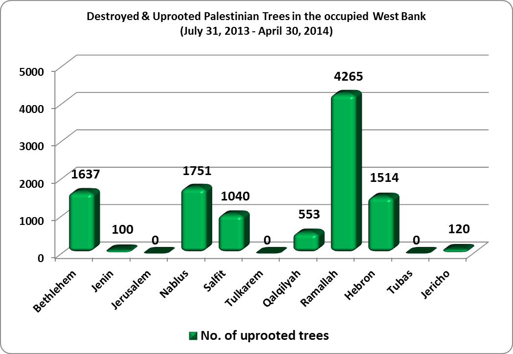
Israel is going further and further with its attacks to target Trees, burn and destroy a very important source of income for many Palestinian families in the occupied Palestinian territory. During the period of July 31, 2013 and April 30, 2014, The Israeli occupation Army and Settlers destroyed 10980 fruit trees (mostly olives) in the occupied Palestinian Governorates. Ramallah Governorate recorded the highest in the number of uprooted trees during the aforementioned period, where 4265 trees were either uprooted, destroyed, cut or sprayed with chemical substance. Incidents of uprooting trees were mostly recorded in Sinjil and Turmusayya villages to the north of Ramallah city.
The reason behind targeting these two Palestinian villages in particular is their proximity to what Israel defines as a“ settlement corridor” between Ramallah and Nablus Governorates. This corridor includes the settlements of Shilo, Mitzpe Rahel, Eli and Rechalim settlements in addition to a number of Israeli outposts in the area. Israeli settlers living in the aforementioned settlements keep targeting Palestinian agricultural lands and trees located within this “Settlement corridor” and often harass Palestinian farmers and frighten them to prevent them from accessing lands in those areas, allowing settlers claim more land and annex them to the settlements nearby. See Chart 5
Issued plans and Tenders in Israeli settlements in the occupied West Bank
Though Palestinians went back to the negotiating table with the Israelis and the Palestinians’ long insisting precondition to stop settlement expansion in the occupied West Bank, Israel didn’t stop its settlement activity in the oPt; instead, it gave the green light for new colonial neighborhoods and plans to be implemented in various settlements in the oWB, including those settlements in East Jerusalem. According to the available data, Israel approved the building of 17388 settlement units in 37 Israeli settlements in the oWB during the aforementioned period (July 31, 2013 & April 30, 2014). The majority of tenders targeted Israeli settlements in Jerusalem Governorate and the major settlement blocs in the West Bank (Gush Etzion, Ariel, Ma’ale Adumim, Giv’at Zeev and Modi’in Illit) which Israel seek to annex and keep under its control in addition to the Eastern Segregation Zone area and the so called “Israeli Corridors” area.
|
Table 1: Plans and tenders in Israeli settlements in the occupied West Bank |
|||||||||
|
No. |
Settlement Name |
Aug-13 |
Oct-13 |
Nov-13 |
Dec-13 |
Jan-14 |
Feb-14 |
Mar-14 |
Total |
|
1 |
Ramat Shlomo |
*396 |
1500 |
0 |
0 |
0 |
0 |
0 |
1896 |
|
2 |
Betar Illit |
36 |
0 |
238 |
40 |
*24 |
0 |
0 |
338 |
|
3 |
Har Homa |
210 |
0 |
130 |
0 |
0 |
612 |
*146 |
1098 |
|
4 |
Alon Shevut |
*60 |
0 |
0 |
0 |
0 |
0 |
0 |
60 |
|
5 |
Gilo |
797 |
400 |
311 |
0 |
0 |
0 |
0 |
2398 |
|
6 |
*890 |
||||||||
|
7 |
Ma'on |
*230 |
0 |
0 |
0 |
0 |
0 |
0 |
230 |
|
8 |
Shilo |
*112 |
0 |
*30 |
0 |
0 |
0 |
0 |
142 |
|
9 |
Ariel |
117 |
0 |
18 |
40 |
5 |
0 |
839 |
1019 |
|
10 |
Talmon |
*559 |
0 |
0 |
0 |
0 |
0 |
0 |
559 |
|
11 |
Gilgal |
* 78 |
0 |
0 |
0 |
0 |
0 |
0 |
78 |
|
12 |
Beit Orot |
0 |
*32 |
0 |
0 |
0 |
0 |
0 |
32 |
|
13 |
Ma'ale Adumim – Jerusalem |
0 |
92 |
144 |
0 |
0 |
0 |
0 |
236 |
|
14 |
Efrat |
0 |
149 |
0 |
0 |
227 |
208 |
0 |
584 |
|
15 |
Nekodim- Bethlehem |
0 |
0 |
*12 |
0 |
0 |
0 |
0 |
12 |
|
16 |
Elkana |
0 |
0 |
283 |
0 |
*169 |
0 |
0 |
452 |
|
17 |
Giv'at Sal'it |
0 |
0 |
94 |
0 |
0 |
0 |
0 |
94 |
|
18 |
Karnei Shomron |
0 |
0 |
196 |
80 |
* 108 |
0 |
0 |
384 |
|
19 |
Beit El |
0 |
0 |
30 |
0 |
0 |
0 |
296 |
326 |
|
20 |
Giv'at Zeev |
0 |
0 |
102 |
0 |
*381 |
0 |
56 |
948 |
|
21 |
*409 |
||||||||
|
22 |
Adam |
0 |
0 |
80 |
100 |
*75 |
0 |
0 |
255 |
|
23 |
Nahalia Tal |
0 |
0 |
0 |
*800 |
0 |
0 |
0 |
800 |
|
24 |
Pisgat Zeev |
0 |
0 |
0 |
40 |
0 |
219 |
*40 |
299 |
|
25 |
Immanuel |
0 |
0 |
0 |
100 |
*102 |
0 |
0 |
202 |
|
26 |
Alfei Menashe |
0 |
0 |
0 |
40 |
*78 |
0 |
0 |
118 |
|
27 |
Neve Brat |
0 |
0 |
0 |
0 |
256 |
0 |
0 |
256 |
|
28 |
Ofra |
0 |
0 |
0 |
0 |
*250 |
0 |
0 |
250 |
|
29 |
Telpiot |
0 |
0 |
0 |
0 |
*1800 |
350 |
0 |
2150 |
|
30 |
Kfar Adumim |
0 |
0 |
0 |
0 |
0 |
*19 |
0 |
19 |
|
31 |
Neve Yacoov |
0 |
0 |
0 |
0 |
0 |
238 |
0 |
238 |
|
32 |
Kochav Yacoov |
0 |
0 |
0 |
0 |
0 |
0 |
38 |
38 |
|
33 |
Shevut Rahel |
0 |
0 |
0 |
0 |
0 |
0 |
*353 |
353 |
|
34 |
Alei Zahav |
0 |
0 |
0 |
0 |
0 |
0 |
694 |
694 |
|
35 |
Ramot |
0 |
0 |
0 |
0 |
0 |
0 |
*734 |
734 |
|
36 |
Almog – Jericho |
0 |
0 |
0 |
0 |
0 |
0 |
31 |
31 |
|
37 |
Shavei Shomron |
0 |
0 |
0 |
0 |
0 |
0 |
65 |
65 |
|
|
Total |
0 |
0 |
511 |
0 |
381 |
0 |
56 |
17388 |
Source: ARIJ Monthly Reports Database – Urbanization Monitoring Department, 2014
*Planned building plans
See Chart 6
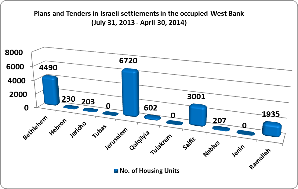
It appears from the foregoing provided data that most of the tenders and plans targeted settlements in occupied East Jerusalem and those surrounding the city. For example, Gilo settlement which was illegally established on lands of Al Walajeh and Beit Jala in Bethlehem Governorate (and south of Jerusalem city), was granted approval for building 2398 housing units. The approval comes due to the settlement’s strategic importance to the Israeli Government in terms of location first, as the settlement is located between Jerusalem and Bethlehem Governorates, and constitutes a geographical link between settlements in the south (mainly the Gust Etzion settlement bloc and in Hebron Governorate) with settlements inside the municipal boundaries of Jerusalem. Second, the settlement is located in the area that Israel annexed in 1967 to illegally and unilaterally expand the borders of Jerusalem Municipality and is now seeking to annex to its proper through the construction of the Israeli Segregation Wall. This in turn will affect the demography of the city of Jerusalem for Israel’s favor, at the same time, it will deepen the separation between the city of Jerusalem from Bethlehem Governorate.
Israeli Colonial plans in occupied West Bank
During the nine-month period of the negotiations between the Israelis and the Palestinians, Israel announced for further Israeli settlement plans in the occupied Palestinian territory. Below is a detailed description of the plans as announced:-
— On November 26, 2013, the Israeli Civil Administration approved a master plan that would retroactively legalize Giv’at Salit outpost in the Jordan Valley area and facilitate the construction of 94 new settlement units, a commercial area and some public buildings on 168 dunums of land. The outpost was established in the year 2002 and today it houses around 70 settlers. The outpost is located in close proximity of Mechola settlement in Tubas Governorate.
— On November 29, 2013, the Israeli Occupation Authorities declared their intention to expand the master plan of Yakir settlement, thus affecting 1200 dunums of Palestinian land in Deir Istiya village. According to the 1991 master plans of the Israeli civil administration (ICA), Yakir & Nofim settlements share the same master plan which is designated for the expansion of the two settlements in the future and is twice the area of the current settlements area which stands at 1302 dunums.
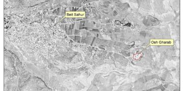
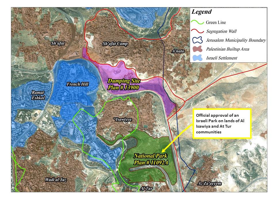
— On November 30, 2013, Israel approved the Mount Scopus Slopes National Park plan which will be implemented on lands of Al Isawwiya and At Tur Communities in East Jerusalem. The plan holds No. 11092A. See Map 1
— On February 12, 2014, the Jerusalem Municipal Planning Board called to approve Plan 68858, to allow for the construction of a 13 story building (A Talmudic academy) in Ash Sheikh Jarrah neighborhood, in the heart of Jerusalem city, designated for the Ohr Sameach Yeshiva, plan No. 68858. See Map 2

— On February 17, 2014, the Israel Government approved granting 35 Israeli settlements in the Jordan Valley and the southern Hebron Hills in the West Bank to the list of favored communities or National Priority. The plan was first approved on December 12, 2009 by the Israeli cabinet which included a map on national Priority areas in Israel and included funding dozens of Israeli settlements. The cabinet (that time, in 2009) set 2 billion shekels as a budget for the plan, of which 110 million shekels were designated for Israeli settlers living in Israeli settlements in the occupied Palestinian territory. On January 29, 2012, The Israeli government gave a final approval to the “National Priority Areas” plan, in which, 70 illegal Israeli settlements out of 90 were adopted and will benefit from the cabinet's decision.
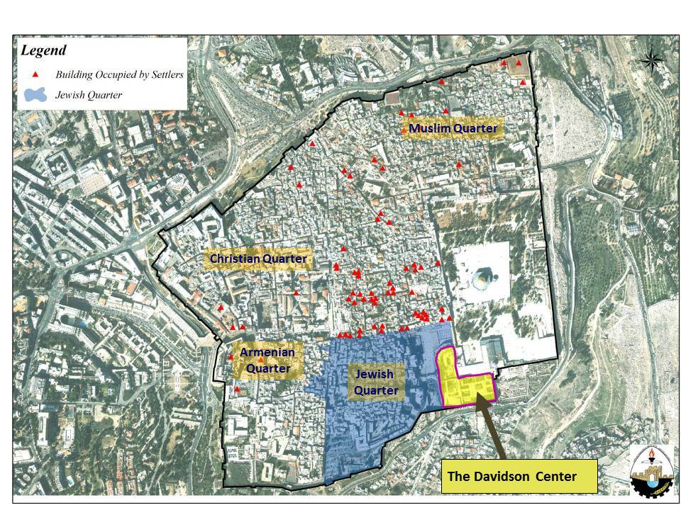
— On February 24, 2014, it was reported that a deal reached behind closed doors to hand the entire area – Al Magharbeh area- or what Israel calls Davidson visitors’ center and the archeological site – to the Elad settler organization. The site is located in the southern part of Jerusalem Old City, next to Dung Gate (Bab Al Magharbeh). See Map 3
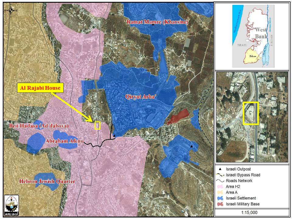
— On March 11, 2014, The Israeli Supreme Court rejected two Palestinians' appeals to gain ownership of Al Rajabi building in Hebron city in the southern West Bank, keeping a 2012 court order to leave the property to Israeli settlers who claimed purchasing the building. The building is located on a 1.1 dunums of land and was built in 1995. It is located opposite to Kiryat Arba settlement and adjacent to the Ibrahimi Mosque. See Map 4
— On March 13, 2014: The Israeli settlers organization, Ateret Cohanim, revealed that it had bought 1,000 square meters (1 dunum) of the Post Office Building in Salah Ad Din street in Jerusalem city, in the area between Damascus Gate (Arabic name: Bab Al Amoud) and Herod’s Gate (Arabic name:Bab Al Sahera).
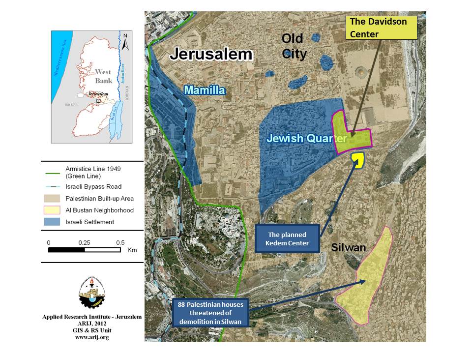
— On April 4, 2014, the Jerusalem Regional Planning and Building Committee at the Municipality of Jerusalem approved the construction of a visitors’ center (Kedem Center) outside the Old City of Jerusalem. The project includes the construction of a tourist center, archeological attraction and parking lot in the area of the Givati parking lot near Silwan city in Jerusalem. The project holds No. 13392. See Map 5
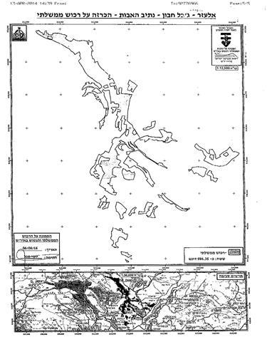
— On April 6, 2014, the so-called “ Custodian of the Absentee Property in Judea and Samaria” attached to the Israeli Ministry of Defense/Civil Administration , Yousi Sigal, issued a military order to confiscate 984 dunums from Al-Khader, Nahalin, Beit Ummar towns west and southwest of Bethlehem Governorate. According to the military order, the "Custodian of the Absente Property” based his decision on an illegal Israeli law issued following the Israeli military Occupation of the Palestinian Territory – (Absentee Property – Judea and Samaria- 59/1967) – in which it considered the targeted lands (984.35 dunums) as state lands while the Palestinian owners of the targeted lands get to submit petitions against the aforementioned order within 45 days. Analysis conducted by the Geo-informatics Department at the Applied Research Institute Jerusalem –ARIJ showed that the confiscation order comes as preliminary step toward expropriating more Palestinian lands in the area that actually located between the illegal settlements of Ele’azar, Rush Tzurim, Nevi Daniel and Alon Shevut with a purpose of fortifying the Gush Etzion Settlement Bloc in general. See copy of the military order and a map 6


— On April 13, 2014, the Israeli Occupation Minister, Moshe Ya'alon, has given the state the green light to retroactively legalize the Netiv Ha’avot outpost in Gush Etzion settlement bloc south of Bethlehem city. The outpost is located north of El’azer settlement and was built in January 2001. Today, the outpost, has more than 40 structures. See Map 7 of the Derech Ha’avot illegal outpost north of Ele’azar settlement.

— On April 29, 2014: the Haaretz daily newspaper revealed that the Israeli Civil Administration approved 28,000 dunums as state land, in areas in close proximity of 27 Israeli settlements and outposts in the occupied West Bank. The newspaper also added that of the 28,000 dunums confirmed as state land by the Israeli Civil Administration, more than 3,700 dunums are on land that has already been used for settlement construction and their designation as state land came to retroactively legitimize the construction going on in the settlement. Analysis of the case showed that 15 out of the 27 targeted settlements are located east of the Segregation Wall path, while the remaining 12 settlements are located in the area Israel is planning to annex to its proper through the construction of the Segregation Wall (in the Western Segregation Zone). Additionally, Hebron Governorate has the highest share of land designated as State Land, followed by Tulkarem and Qalqilyia Governorates respectively. See Chart 7

To conclude,
After 9 months of negotiations, and despite the efforts exerted by the United States to stop settlement activity and stop the Israeli escalation in the occupied Palestinian territory, Israel is not interested in the success of the talks or in any offer related to the peace process or at least progress toward this end; this is evidenced by the Israeli continuous violations which have not stopped since the beginning of the direct talks, and affected Palestinian civilians, their land, homes and trees.
[1] Declaration of Occupied Land as "Closed Areas": Military Order No. 378, 1970: According to Article 90 of Military Order No. 378, 1970150 any "military commander" (i.e. any officer) is empowered to declare by a written order any area or place as a "closed area" for the purpose of the above order. The ownership of closed areas remains in the hands of the residents, but they are deprived from their right of use of the land without any compensation.
[2] According to OSLO II Interim agreement of the year 1995, the Palestinian territory was divided into areas A, B, and C. In Area A (17.7% of the WB area), the Palestinian Authority had complete autonomy over administrative and security issues; where in area B (18.3% of the West Bank area), the Palestinian Authority has control over civil responsibilities; while in Area C, Israel had full control over the area which constitutes 61% of the total area of West Bank. Palestinians plan to build and expand in area “C”, it is compulsory that they apply for a permit to the Israeli Civil Administration (ICA) in order to obtain building permits. The case is the same in occupied East Jerusalem where Palestinians have to apply to the Jerusalem Municipality in order to obtain a permit for a new building or expansion of existing building/house.
Prepared by:
The Applied Research Institute – Jerusalem