Violation: a colonial plan to confiscate 800 agricultural dunums for the favor of Shilo colony
Location: the southern part of Qaryut
Date: 27/03/2014
Victims: the residents of Qaryut
Details:
The so-called Settlement Sub-Committee of the Israeli Supreme Council of Planning announced depositing a detailed plan 1 no.(15/205), which is the modified version of the regional plan(S/15) issued in November 2010. The plan was published in al-Qudus newspaper, page34 on27/11/2014. Noteworthy, the advertisement was published vaguely in terms of lands owners and locations.
According to the new plan, the chosen lands for usage change have been previously confiscated from the area of natural block no.1 of Ras Moris and al-Batayen, and natural block no.4 of Silon and al-Sararah. The aforementioned locations are located within Qaryut southern lands nearby Shilo colony and the bypass road no.60.
According to the advertisement, the land usage will be changed from touristic and agricultural to commercial under specific restrictions and regulation on usage and new constructions as described by the occupation. Archeological gardens in addition to ideal farms are suggested to be implemented.[1]

Photo 1: the newspaper advertisement
If implemented, the residents’ hopes in having a village entrance vanish:
This scheme would crush any hope in re-opening Qaryut southern road that links to the bypass road no.60. The road saved 20 km on travelers towards Ramallah but now residents have to suffer to reach their destination.

An aerial image of Qaryut showing the closed southern entrance, which causes 20km more to reach Ramallah
The deputy of Qaryut village council Mr Bashar al-Qaryuti to the LRC observer stated that: “there is an imminent threat of many negative hazards not only on the economic status of the village but on the life standards of Qaryut as well. According to the plans, the sum of the targeted lands is around 800 agricultural dunums owned by the villagers. Those lands have once been a source of living for most of the residents”.

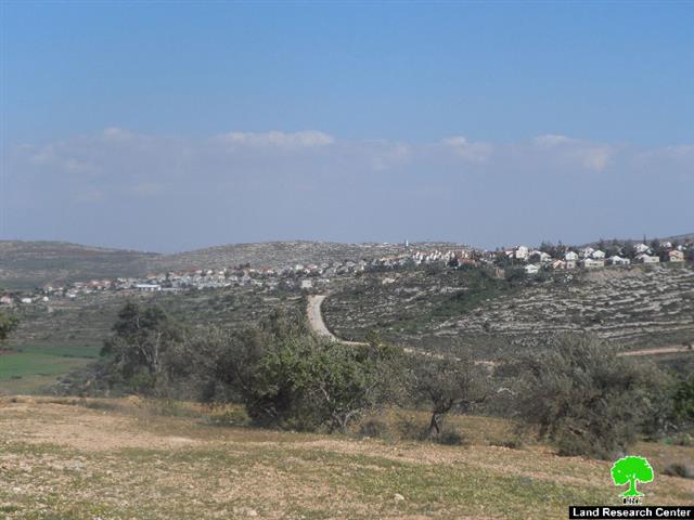
Photo 2: the targeted location according to the advertisement/ Qaryut village
Judaizing Khirbet Silon entirely:
According to al-Quds newspaper advertisement, the occupation is allowing itself to change the landmarks of Silon for the sake of establishing an Israeli museum and a touristic area on the Palestinian ruins in that very place. This step goes under the process of Judaization of Palestinian villages and history.
Preparations were made for the grand opening of Khirbet Silon or the so-called Shilo, as described by the occupation, after been declared a touristic Jewish spot. Final touches are to be put before the opening of a touristic center located atop of a hill overlooking Silon.

Photo 3: Qaryut undergoing excavation activities
The occupation government devoted a budget of millions of dollars to implement the project which is suggested to be opened in a matter of weeks. The new touristic center consists of a round-shaped building with dome leaning to triangle rocks. According to the Israeli false story, there are some remains of a coffin from the Old Testament era that the Israelis brought when they took Shilo as their capital.
It should be mentioned that during the time of the previous government, the Israeli Ministry of Education declared Silon of a Jewish heritage and one of the school trips attractions for the right-wing extreme Jews. This came in synchronization with declaring the Abraham mosque in Hebron and Josef tomb in Nablus as part of the Jewish heritage.
Noteworthy, Silo is known for ancient architectural monuments where it reserves different antiquities from different eras including Canaanite Roman Byzantium and Islamic.
One of the village famous monuments is al-Omari mosque that dates back in time to the Abbasside era. There are also two churches beautifully made of mosaic from the Byzantium time. Silo includes ancient caves, which are Roman tombs or houses engraved in the rock.
The engraved in rocks Roman wells are of the distinguished attractions in place. The wells were used to harvest orand gather water to be pumped in a major pool that has been used for irrigation. In addition, there is a place called al-Mideh in which Jesus prophetic story of the feast took place.
A plan to establish Great Shilo:
Mr. Ghassan Daghlas, the person in charge of the colonial file in the northern part of the West Bank, stated to an LRC observer that: "There is an old plan to erect the Great City of Shilo, same as Ariel. The planned city is meant to further solidify the stance of the Jewish presence in the West Bank and blow up all peace talks and settlement resolutions with Palestinians as the outposts of Givat Ariel in Shilo and Eli in Shvut Rachel and Adi Ad will be merged through infrastructure projects that ultimately lead to the establishment of the Great City of Shilo".
Shilo was constructed in the beginning of the 80s of the last century. It includes religious centers and a synagogue. The colony confiscated no less than 450 dunums of Qaryut lands.
photo 4: Shilo colony located on Qaryut lands
About Qaryut:
It is located 20 km to the south east of Nablus city; a 4.5 km road connects the village to Nablus-Jerusalem road, the road has been closed by the Israeli Occupation Authorities since 2000. Its total area is about 8,471 dunum, 312 dunums of residential areas. Around 2,321 people currently live in the village.
The Israeli Occupation Authorities expropriated about 1,332 dunums for the expansion of the following colonies:
Shilo: established in 1978; its share of Qaryut lands was about 779 dunums and the residential area of the settlement is about 1,347 dunums.
• Eli: established in 1984. It devoured 553 dunums of the village lands. Its built up area is 3,360 dunums. (source: Geographic Information System GIS _ LRC)
[1] The deposit of master plan: is usually to announce the planning of a new colonial location or the modification on expansion and the change of lands usage, which have been confiscated and classified as public property at time of Palestinian possession. Afterwards, the lands get re-classified as residential areas andor facilities of a colony at time of Israeli possession. The announcement is issued by “the Civil Administration of the Judea and Samaria – the Planning Supreme Council- the Sub-Committee of Settlement”
The aforementioned procedures show Israel explicit racism which is worse than the apartheid known in South Africa.
Prepared by
The Land Research Center
LRC


