Violation: the occupation notifies 5.3 dunums with confiscation
Date: 28/11/2013
Location: Aqraba town/ Nablus
Perpetrators: the army of the Israeli occupation
Victims: residents of the town
Details:
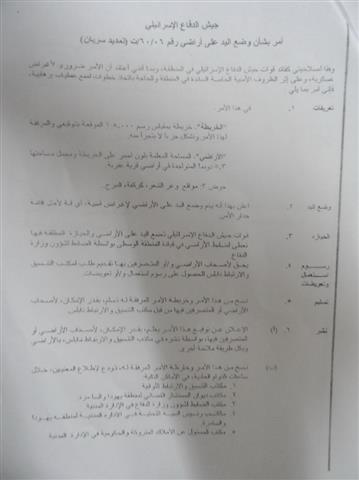
On November 28th 2013, the authorities of the occupation served a military order no. (T/06/06) entitled " extension of confiscation" on the municipality of the Aqraba.
The order stated an enforcement "extension" on the expropriation order of 5.3 dunums from the village of Aqraba. The order was served originally in 2006 and was re-served recently for the favor of establishing a segment of the apartheid fence to separate the lands of the village from the bypass road no.505, which crosses Aqraba.
According to the military order, the targeted lands are located within the natural block no.3; location of W'ir al-Sha'ar and al-Marj.


The military order no.(T/06/06) with maps attached to it
The mayor of Aqraba Mr. Ayman Bani Fadil to the LRC researcher stated that: " this order has a serious implications on the residents. If implemented, the fence will terminate the town two main road that are sealed since 2000, connecting it with the bypass road no.505. Not only that, farmers will find difficulty in accessing their lands, which are located in front of the road.
About Aqraba:
18 kilometers to the southwest of Nablus, Aqraba can be set as an example of a recurrent target for the Israeli occupation attacks. The village total area is 34,660 dunums, mostly, agricultural lands. However, the Israeli occupation announced more than 281,000 dunums of the village lands military zone where Palestinians are not allowed to exploit in any way while soaking the area with various colonies including Gitit. That left only 1,350 of Aqraba land to be built-up area of the village.
The colonies are expanding on daily basis; they are classified as “agricultural settlements”; in addition, the Israelis have placed numerous watch towers and military encampments in order to control the whole region.
In 1969, ‘Aqraba witnessed the milling of by-pass road “506” which connects all the Israeli colonies to the east of ‘Aqraba besides easing the movement of the Israeli Occupation Army vehicles in the area; however, the Palestinians are not allowed to even get near the road.
More than 500 Palestinians are residing in nomads gathering around ‘Aqraba; the residents of these gathering face day-to-day threats against their houses, tents, shacks; basically, their existence. Additionally, the Israeli colonists try to chase these people out of their fields in an attempt to take over the area.
‘Aqraba is inhabited by around 8,180 people with unemployment reaching up to 50% because of the hard conditions imposed by the Occupiers.
Prepared by
The Land Research Center
LRC