On the 27th of June, 2013, the Israeli Daily Newspaper (Haaretz) published on its Hebrew website that the improper conduct of the head of the Israeli Civil Administration, Motti Almoz, enabled the expansion of Beit Arye settlement west of Ramallah at the expanse of a nearby nature reserve, Nahal Shilo. This statement was confirmed by the Israeli Supreme Court in its response to a petition filed to the court by Israeli settlers of Beit Arye settlement regarding this matter.
The expansion plan of Beit Arye settlement was first promoted in late 90’s but it was until the year 2000 that the expansion plan was first approved. The plan didn’t go into the implementation phase because it had to go through some modifications throughout the previous years and was finally approved by the Israeli Civil administration in 2012. According to the approved plan, the borders of the of nature reserve, Nahal Shilo, didn’t match with the actual border of the Nature reserve, the thing that led to the ratification of a number of new housing units inside the borders of the nature Reserve, the thing that created a conflict between Israeli settlers of Beit Arye settlement and the Israeli Civil Administration. The Court stated that the Israeli Civil Administration vowed to work on amending the borders of the Nature Reserve to match with the building plan in Beit Arye settlement.
The Nature Reserves in occupied West Bank
There are 48 nature reserves in the Occupied West Bank and stand on a total land area of 703 km², (12.4% of the total area of the West Bank. 88% of the Nature Reserve lie in the area classified as ‘C’ area, which falls under the total control of the Israeli Authorities; whereas, 12% of these nature reserves are located in the areas classified as “A” [1] and “B [2] where the PNA retain control over these area and are managed by the Ministry of agriculture (ARIJ, 2012). See Map 1
 |
Following the Oslo Accords, 19 Nature Reserves were handed to the PNA by Israel; plus, an additional 7 Nature Reserves were suggested by European Quality Assurance (EQA). However, not all the 26 Nature Reserves are open for public visit or can be even mapped due to the lack of information about their location from the Israeli side such as Beit Hijeh, Sheikh Tabban and Za’tara Nature Reserve; additionally, some other Nature Reserve cannot be visited since they are located within the borders of an Israeli Settlement (such as Ballutet Taffouh). Table (1) gives details of the nature reserves that were handed to the PNA following the OSLO Accords. Names of Nature Reserves handed back to the PNA following the Oslo II interim Agreement
|
Table 1: Names of Nature Reserves handed back to the PNA following the Oslo II interim Agreement
|
||
|
No.
|
Name of Nature reserve
|
Governorate
|
|
1.
|
Al-Hashmee
|
Ramallah
|
|
2.
|
Deir Ammar
|
Ramallah
|
|
3.
|
Ein Darra
|
Ramallah
|
|
4.
|
Fahmeh
|
Jenin
|
|
5.
|
Jabal-Alkabeer
|
Nablus
|
|
6.
|
Jerusalem Wilderness
|
Bethlehem
|
|
7.
|
Sheikh Katrwany
|
Ramallah
|
|
8.
|
Sheikh Zayed
|
Nablus
|
|
9.
|
Shoubash
|
Jenin
|
|
10.
|
Sirris
|
Jenin
|
|
11.
|
Tammoun
|
Tubas
|
|
12.
|
Tayysir
|
Jenin
|
|
13.
|
Um-Altutt
|
Jenin
|
|
14.
|
Wadi Al-Dlb
|
Ramallah
|
|
15.
|
Wadi Zarqa Al-Elwey
|
Salfit
|
|
16.
|
Al Qarrin
|
Hebron
|
|
17.
|
Deir Razeh
|
Hebron
|
|
18.
|
Ein Al-Uja
|
Jericho
|
|
19.
|
Suba
|
Hebron
|
|
20.
|
Um Al-Saffa
|
Ramallah
|
|
21.
|
Wadi Al-Quff
|
Hebron
|
|
22.
|
Wadi Al-Qilt
|
Jericho
|
|
|
Source: The Geo-Informatics department, – ARIJ-2013
|
|
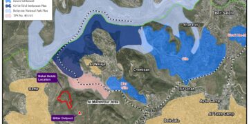
The geopolitical status of Nahel Shilo Nature Reserve [3]
Nahel Shilo Nature Reserve is located northwest of Ramallah city and stands on a total land area of 15134 dunums, (15.1 km²). According to the Oslo II interim agreement of 1995, the land on which Nahel Shilo nature reserve stands is classified into areas A, B and C [4], where 340 dunums (2.2% of the total nature reserve area) is classified as area A; while 2862 dunums (16% of the total nature reserve area) is classified as area B. The remaining area of the Nature reserve, which amounts to 11932 dunums (78.8% of the total nature reserve area), is classified as area C. Despite such classification, Israel administers and manages the Nature Reserve and Palestinian administration of the Nature Reserve (Nahal Shilo) is totally prevented. See table (2) below:
|
Table 2: The classification of Nahel Shilo nature reserve land with accordance to Oslo II interim agreement in 1995
|
||
|
Area
|
Area in Dunums
|
The total percent of the Area
|
|
A
|
340.2
|
2.2%
|
|
B
|
2861.5
|
16%
|
|
C
|
11932.3
|
78%
|
|
Total
|
15134
|
100%
|
|
Source: ARIJ-GIS Unit, 2013
|
||
|
Map 2: Nahal Shilo Nature Reserve
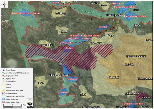
Since the Israeli occupation of the West Bank in 1967, Israel started changing the land-use of the Palestinian Territoryfor its own benefit,with no regard to the existing Palestinian population and their properties, Nature Reserves and farm lands. The need for reinforcing its existence in the territory and imposing irreversible facts on the ground, Israel created a set of contiguous settlements all over the Palestinian territory. Some of these settlements were established on lands that were originally classified by Israel as Green Areas or Nature Reserve. The aforementioned classifications were off access to the Palestinians so that Israel could prevent the Palestinian Urban expansion and development in the area, while at the same time, it exploited such areas for its own benefit . Nahel Shilo Nature Reserve is one example of the Israeli mis-use of land. The Reserve has been profoundly suffering from the Israeli occupation practices as it was destructed for the favor of constructing and expanding 3 illegal Israeli settlements throughout the years of occupation: Beit Arye, Har Alei Zahav and Pedu’el. 667 dunums (4.4% of the total Nahal Shilo area) have been expropriated since the construction of these settlements and still the land theft is ongoing as the Israeli government seeks to inflate the realm of Beit Arye settlement to match with its master plan of the settlement which designates future areas for settlement expansion. Table (3) below gives more details about these illegal settlements:
|
Table 3: The Israeli settlements and the amount of area confiscated from Nahel Shilo nature reserve
|
|
|
Settlement name
|
Area confiscated in dunums
|
|
Beit Arie
|
248
|
|
Har Alie Zahav
|
30
|
|
Pedu’el
|
389
|
|
Total
|
667
|
|
Source: ARIJ-GIS Unit, 2013
|
|
Furthermore, Beit Arye settlement, was constructed in 1981 at the expanse of three Palestinian villages located west of Ramallah city, they are: Bani Zeid, Al Lubban Gharbi and Aboud. According to the Urbanization Monitoring Department at the Applied Research Institute – Jerusalem (ARIJ), the Israeli authorities have expropriated a total of 1,434 dunums from the aforementioned Palestinian villages for the favor of constructing and expanding the settlement of Beit Arye in order to provide additional housing units to Israeli settlers willing to move and live in it. Table (4) below gives more details about this illegal settlement.
|
Table 4: Land area confiscated from Palestinian villages in Ramallah Governorate for establishing the Settlement of Beit Arye
|
|
|
Palestinian villages and towns
|
Lands confiscated (in dunums)
|
|
Bani Zeid
|
50
|
|
Al Lubban Gharbi
|
876
|
|
Aboud
|
508
|
|
Total
|
1434
|
|
Source: ARIJ-GIS Unit, 2013
|
|
Nahel Shilo and the Israeli segregation wall
Additional to the illegal settlements, the Israeli segregation wall plan published by the Israeli ministry of Defense website in April 2007, showed that this nature reserve along with the Beit Arye, Ofarim, Peduel, Har Alei Zahav settlements will be included within the area that Israel seeks to annex to its proper once the wall is completed. This area has become known to the local Palestinians as the ‘Israeli Segregation Zone’ as it isolates lands, communities and natural resources within its path and deprive Palestinians their right to access these lands.
Previous Cases like Nahel Shilo
The destruction and distortion of nature reserves in the occupied West Bank for the implementation of the various Israeli colonial projects is just an integral part of what happens in the occupied West Bank. Throughout the years of the Israeli occupation, Israel exploited the term “Nature Reserve” for the sake of Israeli settlements. Such exploitation was obvious in Bethlehem Governorate, when Har Homa settlement was established in 1997.
The mountain of Abu Ghneim was considered one of the biggest forests and vital green areas in Bethlehem governorate before the Israeli government’s unilateral decision in 1979 to replace the green area with an Israeli settlement.
To conclude
Israel is keen to continue its hegemony over the Palestinian Territory with any mean possible as long as it benefits its settlement program in the territory, even if it takes the distortion of nature reserves and green areas for that purpose. This is exactly what is happening to Nahal Shilo Nature Reserve.
Throughout the 46 years of Israeli occupation, the successive Israeli governments worked hard on annexing most of nature reserves to its territory, where it prohibited Palestinian existence, management and development in these areas for any reason.
Israel’s plan doesn’t only stand at capturing Palestinian land and housing Israeli settlers, but to make life impossible for Palestinians to stand eventually force them to leave.
The destruction of Palestinian nature reserves in favor of establishing Israeli settlements and expanding the existing ones constitute a grave breach of all articles from the International law that demands the protection of natural environment. Some of which are listed below:
- Under the Israeli-Palestinian Interim Agreement on the West Bank and the Gaza Strip Annex III, Protocol Concerning Civil Affairs, Article 12 Environmental Protection, clause 14, ‘Israel and the Palestinian side shall cooperate in implementing principles and standards, which shall conform with internationally accepted principles and standard ,concerning the protection of endangered species and of wild fauna and flora, including restriction of trade, conservation of migratory species of wildlife and preservation of existing forests and nature reserves’. So the Israeli policies of land confiscation, nature reserve destruction and natural resource degradation are against international laws and resolutions.
According to the Palestinian environment law number (7) for a year 1999:
- Article (40) ‘the ministry, in cooperation with competent authorities, shall designate bases and criteria to maintain natural reserves and national parks, supervising, announcing and demarking them’.
- Article (41) ‘it shall be banned to hunt, kill or catch land birds, land and maritime animals and fish itemized in the executive list of this law. It shall be prohibited, too, to own, transfer, wander with or display such birds and animals either dead or alive; their nets and eggs shall not to be destroyed’.
- Article (42) ‘the ministry shall designate necessary conditions to maintain vital variety in Palestine, in collaboration with competent authorities’.
- Article (43) ‘The ministry , in coordination with competent authorities, shall undertake setting sufficient fundamentals and criteria to itemize plants, forest and land trees that cannot be cut, cultivated, damaged, either temporarily or permanently to guarantee their continuity and perpetuity’.
- Article (44) ‘anyone shall be banned to do any activities and behavior leading to endangering natural preserves, forest areas, public parks, historical and archeological sites or affect aesthetic level of such areas’.
- Article (72) ‘Anyone who violates provisions of article (44) of this law shall be punished by a fine not less than twenty Jordanian dinars (JD) but not more than two hundred dinars (JD) or their equal in the legally active currency or jail for not less than three days but not more than one month or by one of the two penalties’.