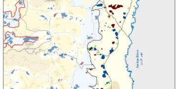
On July 7, 2013, the District Planning and Building Committee related to the Israeli Ministry of Interior approved the town plan No. 12222 to build what is known as “Refaim Metropolitan Park” in the southern parts of the city of Jerusalem. According to the plan that developed by the Israeli Municipality of Jerusalem and what is so-called “Israeli Development Authority”, Refaim Valley Park will occupy an area of 5,700 dunums, of which, 1850 dunums beyond the Green Line (Armistice Line of 1949) on lands belonging to t Al-Walajeh village residents (1200 dunums), while the remaining areas owned by the residents of the nearby town of Battir.
It’s worth pointed that Refaim Park is part of three large metropolitan “parks and green areas” being developed by the Israeli Municipality of Jerusalem and the Jerusalem Development Authority. Two of these parks, Arazim and Motza, are entirely within the Green Line in the western parts of the city Jerusalem.
The plan designates the area for forestation, preservation, recreation and light service facilities. Unlike the string of parks located around the Old City, this area does not resonate with religious historical and cultural sites, and the primary motivation behind it is genuinely environmental.
Moreover Refaim Park will be linked with the Arazim and Motza Parks by a 42 km bicycle path and hiking routes. Additionally an extreme sport center, horse riding center, water park, outdoor education center, sport fields, picnic areas, and arboretum will be created in the park system, with a NIS 250 million endeavor funded by the Israeli Municipality of Jerusalem, Israeli Prime Minister’s Office, Jerusalem Development Authority, and Ministry of Environmental Protection.
As a matter of fact, all al-Walajeh private lands, that lie between the Green Line and the Segregation Wall encircling the village of al-Walajeh, would be under the authority of the Israel Nature and Parks Authority, and even more the proposed park occupies all of the open and public spaces between the expanding settlements on the southern parts of the city of Jerusalem while erasing the Green Line and de facto shaping a buffer zone interrupts the geographical contiguity between Jerusalem and Bethlehem governorate. See Map 1
 |
No Consolation for Al-Walajeh Residents
Formally, and on January 27, 2012, the Israeli authorities deposited the town plan of Refaim Metropolitan Park for public review and considering objections against the plan, where on June 20, 2013, the Israeli Planning and Building Committee held a hearing session for Al-Walajeh residents submitted by the attorney Gayyath Naser and on behalf of Al-Walajeh residents in which he clarified the catastrophic consequences of designating private owned Palestinian lands as a national park which would restrain the owner’s right to control and access to their own lands.
In an interview with ARIJ field workers Abdulla Abu At-Tin, the head of Al-Walajeh village council indicated that since the year 1967, the resident of Al-Walajeh are facing an ever-ending suffering resulted by the Israeli colonial activities that took place on their lands starting from establishing the illegal settlements, house demolition, building the Segregation Wall that trapped the village and turned it into a prison.
Mr. Abu At-Tin also added that “ it seems that all of these expansionist and colonial activities that targeted the village lands didn’t satisfy the Israeli occupation who is pushing Al-Walajeh residents toward voluntary displacement from their village where the residents strangulated in their village and deprived from their legitimate right to live freely and reaching to their own lands”. Photos 1-4: the proposed park site in Al-Walajeh village:
|
|
|
|
The Fading Village of Al-Walajeh
Al -Walajeh is a small Palestinian village located about 4 kilometers to the northwest of Bethlehem city and 8.5 km to the southwest of the city of Jerusalem. The village houses a population of approximately 2,373 residents (PCBS Population Projections -2013). It is bordered by Battir and Husan villages from the southwest, by Sharafat village and Gilo settlement (established in 1971) from the east and by Har Gilo settlement (established in 1972) from the southeast, and the rest of the village is loop by the Israeli bypass road # 60.
It is worth mentioning that Al Walajeh Before the 1948 war, was spread over an area of 17.8 km2 and its boundaries extended westwards beyond the Armistice Line (the Green Line), and after the 1948 war, the village lost 75% of its lands and came to spread only over a total land of 4.4 km2 (24.8 % of its original area).
Following the Israeli occupation of the Palestinian lands in the year 1967, Israel unilaterally declared a new municipal boundary for the city of Jerusalem, where it expanded from 6.5 km² to 71 km² to include lands from nearby villages, these lands where then annexed to the state of Israel. Part of Al Walajeh village, in particular Ein Juwaiza neighborhood which has an area of 2.1 km2 was included within this annexed land.
Glance about the Segregation Wall in Al Walajeh Village
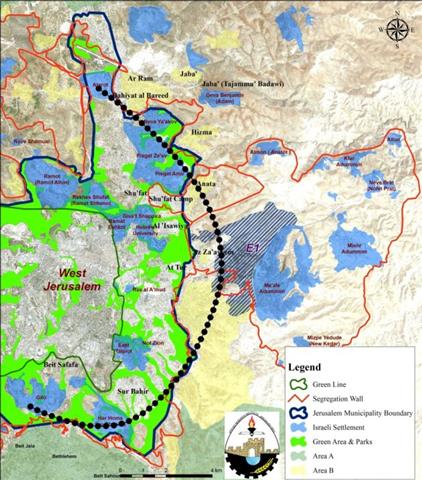
According to the updated Wall plan of April 30, 2007, the Wall will place Al-Walajeh village in an isolated enclave, sealed off from all directions, east, west, north and south and from the neighboring Palestinian communities; Battier, Hussan, Beit Jala and from Bethlehem city center. The Wall, according to the map, was shifted northwards to include the neighborhood of ‘Ein Al Juwaiza on the Palestinian side of the Wall, but sealed off the village completely from its southern part with a 2.5 km long Wall that will run alongside bypass road number 436.
In total, the Israeli Segregation Wall plan will extend for 7.9 km on the lands of Al-Walajeh, of which 3.5 km will be barbed wires. The Wall will isolate a total sum of 2210 dunums of the village’s lands that is 50.2 % of the total village area. The road protection strip (the road security buffer zone) will cause the isolation of an additional 1100 dunums of lands from Al-Walajeh village, where these lands will fall south of the Wall and will be inaccessible to the Palestinian residents. Currently, 1.2 km of concrete wall exists around the village, 1.2 km is under construction and 5.5 km are in planning phase to be constructed around the village before the end of 2013. See Map 2
|
Map 2: General view for Al-Walajeh
Weird Déjà vu all Over Again
It’s always about settlements ……….green areas, national parks, open space, it’s always an Israeli pretexts to hide behind its expansionist and colonial desires, where we have significant examples that clarify how the Israeli political bureau harnessing the urban measures to achieve political and geopolitical goals:-
- Jerusalem Master Plan 2000
The “Master Plan of Jerusalem 2000” or “2020” is a plan prepared with the initiative of the former Israeli Prime Minister Ehud Olmert who also served as the Mayor of the Israeli Municipality of Jerusalem (1993-2003) with a declared aim of designing the future scenarios of the city in terms of demographic and urban aspects. See map 3
|
According to the plan the Israeli Municipality of Jerusalem classified 26,300 dunums (%36.7 from the east Jerusalem area) as green areas, of which 4,000 dunums for parks and gardens includes private parks, parks for built-up area and open natural areas. We can easily find that all of the areas declared green areas and parks located around the Palestinian neighborhoods in the eastern part of the occupied city for the purpose of blocking the spaces to be used for future development of the Palestinian Jerusalemites living in these neighborhoods.
- The Planned Settlement of Giv’at Ya’el – Al Walajeh
In the year 2004, the Israeli Municipality of Jerusalem announced a new colonial plan to construct a new Illegal Israeli settlement called ‘Giv’at Yael’ on nearly 5000 dunums of lands confiscated from the Bethlehem Western Rural villages of Battir, Beit Jala, and Al Walajeh northwest of Bethlehem Governorate. According to the Israeli plan, the settlement will have some 20,000 housing units to accommodate +55,000 Israeli settlers.
The illegal proposed settlement of ‘Giv’at Yael’ will physically complete the ring of settlements that separate Jerusalem from Bethlehem and consequently from the West Bank’s southern territory. It will also close off the settlements’ line barrier across the northern parts of Bethlehem starting at Har Homa; east of Bethlehem to Giv’at Hamatos and Gilo north of Bethlehem then to Har Gilo, west of Bethlehem where the link is completed with the planned ‘Giv’at Yael’ settlement. After which the settlement ring continues southward to link with ‘Gush Etzion settlements bloc in the southwestern part of Bethlehem Governorate.
In an analysis conducted by the Geo-Informatics Department (GIS Unit) at ARIJ, we found that the proposed settlement of Giv’at Ya’el located in the site of the plan of Refaim Metropolitan Park which means that the Israeli authorities declared the lands around Al-Walajeh village as green areas to be designated later on for building the settlement of Giv’at Ya’el. See map 1.
- Al-Issawieyyeh and At-Tur National Park
Another national park that included in the “Jerusalem Master Plan 2000” is Al-Issawieyyeh and At-Tur National Park, where the Israeli authorities revealed the plan on January 2012 and the Regional Planning and Building Committee deposited the plan that holding No. (11092 A) for public view on March 2012.
The Israeli plan to confiscate dozens of dunums form Al-Issawieyyeh and At-Tur lands to build a national park would resulted in a catastrophic consequences over the aforementioned towns while fulfilling Israeli colonial goals as follows:
- Separate the two towns from each other.
- Isolating the eastern part of the city of Jerusalem from the West Bank
- The proposed park will find a geographic contiguity between the Old city Basin and Ma’aleh Adumim settlement bloc and E1 area.
- Encircling the two towns from all sides with no alternative way for development.
Remarking on Al-Issawieyyeh and At-Tur National Park, Meir Marglit, left- wing member of the Israeli Municipality of Jerusalem stated: “There’s nothing there but rocks and thorns, certainly nothing to justify a national park…… The only reason for such a plan is to seize lands and hold them as a reserve for a future settlement, while suffocating the Palestinian neighborhoods."
|
|
|
|
Photos 5-8: the site of the proposed Park in Al-Issawieyyeh town in Jerusalem
- Har Homa ….. from Green area to an Israeli Settlement
Har Homa (known to Palestinians ‘Abu Ghneim Mountain’) is an Illegal Israeli settlement located less than 2 km north of the city of Bethlehem. The settlement has been built on the Palestinian-owned lands of Abu Ghneim Mountain which is historically owned by the Palestinian residents of Bethlehem, Beit Sahour, as well as the villages of Um Tuba and Sur Baher.
When Israel occupied East Jerusalem along with the West bank in 1967, it adopted Illegal step to redefine the boundary of East Jerusalem city in a unilateral matter. The new illegal Israeli boundary included Abu Ghneim Mountain, as it was taken out of Bethlehem boundary and classified as “Green area” denying the Palestinian right to use their lands in the site.
Later on and on the year 1990 the Israeli Finance Minister at that time “Isaac Mode’i” issued a confiscation order for vast areas of the mountain under the pretext of “public use”, and accordingly the mountain lands re-zoned from green areas to a building zone to build the settlement at the mountain which is formally started on the year 1997.
Today the settlement of Har Homa became one of the largest settlement in the occupied eastern part of the city of Jerusalem with a population exceed 20,000 settler. The Israeli authorities set a plans to expand the settlement of Har Homa where it was divided into four neighborhoods A, B, C and D, where according to the Jerusalem master plan 2000, the site were neighborhood D to be built, classified as green area and public parks and in the same time there is a plan for residential neighborhood in the same place which is known as “Khallet Al Mazmouria” and owned by the residents of the nearby town of Beit Sahour. See map 4
|
- Solid Waste Landfill à National Park à Settlement Expansion
A new innovative colonial plan to capture more Palestinian private lands revealed on March 23, 2013, by the Israeli Municipality of Jerusalem through the plan No. (13900) which stated the confiscation of 534 dunums privately owned by the Palestinian residents of ‘Anata, Al-Issawieyyeh and Shu’fat Refugee Camp. According to the plan, the seized lands will be used as “landfill” to dump Israeli solid and building waste for the next 20 years and then to be rehabilitated as a National Park for sole Jewish use …….on an expropriated Palestinian lands within 1967 borders!!!
The aforementioned plan has been approved by the local planning and Building Committee and initially accepted by the District Planning and Building Committee prior to being deposited for public review within the coming few months.
“Environmental and Geopolitical Consequences
Coincidently” and in a significant paradox, the targeted dumping site located nearby the E1 area!! and once a geographical contiguity will be found between east and west Jerusalem, French Hill with E1 area Ma’aleh Adumim settlement bloc via West Bank settlements. Moreover , the residents of Anata , Shu’fat Camp , Al-‘Issawieyyeh and the surrounding Palestinian communities will not only affected by environmental hazards , but also will be affected in terms of losing their lands where they will be deprived from their right to build cultivate and develop over their own lands. See map 5
|
The Three Great Walls of Jerusalem
For as long as, Israel considers the city of Jerusalem including its eastern part as the eternal, unified, undivided capital of the State of Israel in which a systematic procedures and measures was taken by the Israeli de facto authority to keep the Jewish superiority in the city demographically and geopolitically. To fulfill the aforementioned desire, and to fortify its capturing of the city, Israel embarked to erect a belt of illegal settlements, Segregation Wall ,Jewish Parks and green areas that enwrap the city from all sides, cutting it off from the West Bank and blocking the Jerusalemite Palestinian communities to eliminate any chance for these neighborhoods to develop. See chart 1 and map 6
|
Legal & International Status
The fact that 35% of the Palestinian lands in East Jerusalem have been expropriated for sole Jewish use under fake pretext of urban development “parks and green areas”, constitute a focal challenge that will make a Palestinian capital in East Jerusalem and with it the two- state solution went unheeded. All forms and aspects of the Israeli colonial and expansionist activities in the Occupied Palestinian Territory including those took place in East Jerusalem constitute a grave breach to the International law rules and conventions with some of which are listed below:
- Article 2 in the Universal Declaration of Human Rights reads that: ‘Everyone is entitled to all the rights and freedoms set forth in this Declaration, without distinction of any kind, such as race, color, sex, language, religion, political or other opinion, national or social origin, property, birth or other status. Furthermore, no distinction shall be made on the basis of the political, jurisdictional or international status of the country or territory to which a person belongs, whether it is independent, trust, non-self-governing or under any other limitation of sovereignty.’
- Article 3 states that ‘everyone has the right to life, liberty and security of person’.
- Article 13 states also that ‘(1) everyone has the right to freedom of movement and residence within the borders of each state.’
- Article 25 states that ‘(1) Everyone has the right to a standard of living adequate for the health and well-being of himself and of his family, including food, clothing, housing and medical care and necessary social services, and the right to security in the event of unemployment, sickness, disability, widowhood, old age or other lack of livelihood in circumstances beyond his control.’
- According to the Fourth Geneva Convention of 1949, Israel, as an occupying power is prohibited to demolish Palestinian houses as stated in Article 53 of the Convention which states that: ‘Any destruction by the Occupying Power of real or personal property belonging individually or collectively to private persons, or to the State, or to other public authorities, or to social or cooperative organizations, is prohibited, except where such destruction is rendered absolutely necessary by military operations.
- Moreover and according to article XXXI of the 1995 Oslo agreement, Israel,is forbidden from building or planning to any project or settlements or any colonial expansion or any plan that lead to change the status of the West Bank and Gaza Strip. The article provides ‘Neither side shall initiate or take any step that will change the status of the West Bank and the Gaza Strip pending the outcome of the permanent status negotiations’.
- Also the International Convention on the Elimination of All Forms of Racial Discrimination (1965), Article 5provides that: ‘States’ Parties undertake to prohibit and eliminate racial discrimination in all of its forms and to guarantee the right of everyone, without distinction as to race, color, or national or ethnic origin, to equality before the law, notably in the enjoyment of the following rights: … (e) in particular … (iii) the right to housing’.
- The Universal Declaration of Human Rights adopted and proclaimed by General Assembly resolution 217 A (III) of, December 10, 1948, Article 17 reads: ‘No one shall be arbitrarily deprived of his property.’ Which means it bans Israel from destroying or confiscating the property of the Palestinians at any case.
- Moreover Art. 23 of the Hague Convention of 1907also provides: In addition to the prohibitions provided by special Conventions, it is especially forbidden to destroy or seize the enemy’s property, unless such destruction or seizure be imperatively demanded by the necessities of war.