On the 28th of December 2012, the Israeli Occupation Authorities handed over Palestinians of Beit Iksa, Beit Surik and An Nabi Samuel villages in the northwest of Jerusalem city, a military order number 89/06/t (amendment 2) to extend the confiscation of 456 dunums of Palestinian owned lands of the aforementioned villages until the 31st of December 2015 to resume the construction of the Segregation wall in the area. The wall, as stipulated in the order, will encircle the village of Beit Iksa from three directions, west, north and south and cut it off from its open spaces and agricultural lands in the east and annex them to Israel, within the Giv’at Ze’ev settlement bloc. It is worth mentioning that the military order number 89/06/t was first issued in the year 2006 and stated the confiscation of 565 dunums of Palestinian owned lands in the aforementioned communities for security reasons, to construct the Israeli Segregation wall. Table No. 1 gives details of the military order No. 89/06/t
Table 1: Details of Military Order No. 89/06/t | |||
No. | Community Name | Block No. | Location Name |
1 | An Nabi Samuel | 2 | Thahr Imran |
2 | Beit Iksa | 2 | Al Jreish |
3 | Kherbit Elwan | ||
4 | Marj Al Kanar | ||
5 | Al Kroum, Al Ghurba | ||
6 | Wa’er Abu Isma’il, Ras Al Rasan, Habeil Satleib, Odeh Al Wa’er, Zaqiq Al Husseini, Hareqat Al ‘Atab | ||
7 | Thar Biddu, Namous Khatab | ||
8 | Qet’at At Tabish, Hareqat Al ‘Aroub | ||
9 | Al Prince | ||
11 | Khallet Al Fasad, Hareeq Kaseem, Shu’ab Hamdan, Hareeq As Sekha | ||
13 | Habel ‘Aqla | ||
3 | Beit Surik | 3 | Wadi Al JouZ (Al Jouz Valley) |
Total | 456 | ||
Source: Beit Iksa Village Council, 2012 | |||
 | |
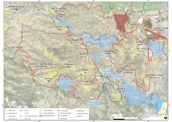
Beit Iksa Village and the Israeli Segregation Wall Plan
On June 30, 2006, the Israeli Ministry of Defense published on its website an updated map of the Segregation Wall route in the West Bank which illustrated changes on the Wall route in Beit Iksa village northwest of Jerusalem city along with changes in other areas in the West Bank; According to updated map, the Segregation Wall in Beit Iksa was re-routed to take the village’s built-up area outside the Wall enclave (outside the western segregation Zone) as was planned according to the previously declared wall routes of February 2005 and June 2004 where the village was totally isolated from the neighboring Palestinian villages of Beit Surik, Beit Ijza, Biddu and the remaining Palestinian villages located in the area.
The change delineated in the published map of June 2006 has never been in favor of Beit Iksa villagers even though the village’s built-up area was set outside the western segregation zone because most of the village’s lands were set within the western segregation zone and will be annexed to Israel upon wall completion.
The Segregation Wall Plan of April 30, 2007
The Israeli Ministry of Defense issued another revised route of the Segregation wall on the 30th of April 2007 affirming the new route of the wall in Beit Iksa village which sets to surround the village from three sides, east, west and south, setting the built up area of the village outside the Western Segregation Zone while isolates most of the village’s land within the western Segregation zone.
Accordingly, the wall will stand to cost the village of Beit Iksa about 98.1% (7840 dunums) of its total land area (7989 dunums) as it will extend a length of 9 km over its lands. The isolated lands are the village’s agricultural lands, natural resources and open spaces that are reserved for the village’s future urban expansion. Table 2 and Map 1
Table 2: Land Use Land Cover of the isolated lands in Beit Iksa Village – Jerusalem Governorate | ||
No. | Land classification | Area (dunums) |
1 | Agricultural Lands | 2185 |
2 | Open spaces | 2742 |
3 | Israeli settlements | 1545 |
4 | Palestinian Built-up Area | 255 |
5 | Wall zone | 62 |
6 | Forests | 1008 |
7 | Artificial Surfaces | 43 |
Total | 7840 | |
Source: ARIJ-GIS Unit, 2012 | ||
|
The Current Status of Beit Iksa Village
The village of Beit Iksa is currently isolated from its neighboring Palestinian villages located in the northwestern part of Jerusalem City, within the Giv’at Ze’ev settlement bloc according to the Wall of February 2005; and despite the changes that were depicted in the maps of June 2006 and April 2007; nothing has been implemented on the ground yet. Villagers of Beit Iksa are entrapped inside the wall and are not allowed to travel to Jerusalem City; Moreover, the only entrance to/exit from the village is through an Israeli checkpoint established on the northwestern side of the village where only villagers of Beit Iksa (those whose identification cards indicate Beit Iksa as their residence place) are allowed to get into and out of the village.
Ramallah City as a Substitute for Jerusalem
Since the outbreak of the Second Intifada in September 2000, Palestinians living in Beit Iksa and the nearby Palestinian villages lost their link to Jerusalem City which was the primary source of services such employment, educational, social and health. Citizens of Beit Iksa village have therefore started to use Ramallah City as a substitute to fulfill these needs. Until 2002, Palestinians living in Beit Iksa were able to use Israeli bypass road 443 to access Ramallah city. Following the closure of this bypass road (443) in 2002, the Israeli Occupation army confiscated more Palestinian lands from several Palestinian communities to construct an alternative road for Palestinians who used to drive on bypass road 443. The road did not meet the minimal needed specifications of Palestinians as driving on this alternative road (to Ramallah city) takes Palestinians from 45 minutes to one hour time, while it used to take them around 10 minutes to drive on bypass road 443 to reach the same destination. This alternative road is part of an Israeli scheme to create two networks of roads, one Israeli and one Palestinian.
Beit Surik Town and the Segregation Wall
The latest revised route of the Israeli segregation wall plan published on the Israeli Ministry of Defense’s website on April 30, 2007 shows that the wall extends a length of 8km on lands of Beit Surik village and causes the isolation and confiscation of 1766 dunums (30.6% of the village’s total land area) of Beit Surik village lands from the south-eastern and north-western sides of the village. The majority of the isolated lands are open spaces and agricultural lands which constitute a major source of income for many Palestinian families in the village. Table 3 & Map 1
Table 3: Land Use Land Cover of the isolated lands in Beit Surik Village – Jerusalem Governorate | ||
No. | Land classification | Area (dunums) |
1 | Agricultural areas | 424 |
2 | Open spaces | 675 |
3 | Israeli settlements | 522 |
4 | Wall zone | 145 |
Total | 1,766 | |
Source: ARIJ-GIS Unit, 2012 | ||
An Nabi Samuel Village and the Israeli Segregation Wall Plan
The latest revised route of the Israeli segregation wall plan published on the Israeli Ministry of Defense’s website on April 30, 2007 shows that the wall has a negative and destructive impact on An Nabi Samuel Village as it will completely isolate the village from its surrounding Palestinian villages bordering it from the west and northwest (Al Jib, Biddu, Bit Hanina Al Balad and Beit Iksa) and include it within the Giv’at Ze’ev settlement bloc., within the western Segregation Zone, Table 4.
Israel envisions a complete geographical separation between Jerusalem city and the rest of the West Bank Governorates as it moves ahead with its plans to construct the segregation wall around the city of Jerusalem and annex the major settlements blocs surrounding the city of Jerusalem from East, northwest and south (the Ma’ale Adumim settlement bloc, the Giv’at Ze’ev settlement bloc. and the Gush Etzion settlement bloc. respectively) to the new boundaries of Jerusalem city; This in turn will undermine the opportunity to establish a sovereign Palestinian State with Jerusalem as Its capital. Table 4 & Map 1
Table 4: Land Use Land Cover of An Nabi Samuel village lands which is isolated within the western Segregation Zone | ||
No. | Land classification | Area (dunums) |
1 | Agricultural areas | 652 |
2 | Open spaces | 544 |
3 | Israeli settlements | 467 |
4 | Forests | 564 |
5 | Palestinian residential areas | 18 |
6 | Wall zone | 6 |
7 | Construction area | 10 |
Total | 2261 | |
Source: ARIJ-GIS Unit, 2012 | ||
Suffering of Palestinians in An Nabi Samuel village caused by the construction of the Israeli Segregation Wall
Before the construction of the Israeli Segregation Wall, villagers of An Nabi Samuel and the surrounding villages used to travel to Jerusalem city for educational, health, social and commercial services. However, following the construction of the Israeli Segregation wall around the city of Jerusalem, the village lost access to most services in the city and became vey much dependant on Palestinian villages located in the northwestern part of Jerusalem such as Biddu, Beit Surik, Beit Ijza and on Ramallah city for accessing such services; this prompted the Israeli occupation authorities to construct a 1.5 km underground tunnel to link Palestinian communities located north of Jerusalem (6 villages) with those located to its northwest (9 villages) through Biddu village and with Ramallah; however, Palestinians must travel only through this tunnel and on a daily basis to reach their destination in the nearby Palestinian villages or in Ramallah; It is worth mentioning that the route Palestinians take through the tunnel is longer in distance and the transportation costs are quite higher than usual. See Map 1
In addition, the village of An Nabi Samuel was closely linked with the Palestinian villages in the north and northwest of Jerusalem city such is Beit Ijza, Beit Surik, Biddu and many others nearby. However, and following the construction of the wall and the underground tunnel, the main road (entrance/exit) of the village was cut off and villages were denied access to it. This road (to the west of the village) was the only access to the nearby Palestinian villages in the north and northwest; Nowadays, the main mean of travel became through the road edging the nearby settlements of Neve Shamuel and Har Shamuel towards the north and then through the tunnel that leads to Biddu village and to Ramallah. It is worth mentioning that the new route that villagers of An Nabi Samuel take is longer than the usual (the old route) and the cost is quite higher.
The construction of the Segregation Wall in International Law
Israel continues with the construction of the Segregation Wall in the occupied Palestinian State, violating the Palestinians’ civil rights for freedom of movement, freedom of religion and proper health services and education, right to work, and also the right to live adequately in their houses and areas of their choice without restrictions, all of which guaranteed by the International law rules and human rights conventions. The ICJ Advisory Opinion on the Legal Consequences of the Construction of a Wall in the Occupied Palestinian Territory in July 9, 2004. “The Court has reached the conclusion that the construction of the wall by Israel, the occupying power, in the Occupied Palestinian Territory including in and around East Jerusalem and its associated régime, is contrary to international law and has stated the legal consequences that are to be drawn from that illegality”. Also “Israel is under an obligation to make reparation for all damage caused by the construction of the wall in the Occupied Palestinian Territory, including in and around East Jerusalem.” Also Articles 53 &147 of the Fourth Geneva Convention indicated that: Extensive destruction and appropriation of property not justified by military necessity and carried out unlawfully and wantonly. is a grave breach of the Convention. Additionally, Art. 23 of the Hague Convention of 1907 also provides: In addition to the prohibitions provided by special Conventions, it is especially forbidden to destroy or seize the enemy’s property, unless such destruction or seizure be imperatively demanded by the necessities of war. Also, under the Universal Declaration of Human Rights adopted and proclaimed by General Assembly resolution 217 A (III) of, December 10, 1948, Article 17 reads: ‘No one shall be arbitrarily deprived of his property.’ Which means it bans Israel from destroying or confiscating the property of the Palestinians at any case.
[1] The area between the 1949 Armistice Line (Green Line) and the path of the Segregation wall.


