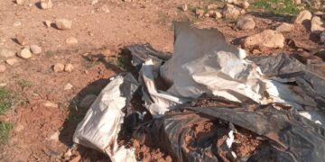
On the early morning of January 24, 2012, the Israeli Army bulldozers accompanied with the Israeli Occupation Army, stormed Wa’r Al-Beik area in ‘Anata town northeast of the city of Jerusalem and started without prior notification to demolish seven residential barrackses owned by Palestinian Bedouin families under the pretext of lacking building permits due to their location in an area classified as ‘C’ according to OSLO II Interim agreement of 1995 where Israel retains full control over security and administrative issues. The demolished structures are owned by:-
1. Ahmad Mohammad Suleiman Jahalin.( 5 family members displaced).
2. Mousa Mohammad Suleiman Jahalin.( 8 family members displaced).
3. Youseph Mohammad Suleiman Jahalin.( 7 family members displaced).
4. Jibril Mohammed Suleiman Jahalin.( 2 family members displaced).
5. Omar Mohammad Suleiman Jahalin.( 5 family members displaced).
6. Jamiela Mohammad Suleiman Jahalin.(5 family members displaced).
7. Slim Shawamreh. (7 family members displaced).
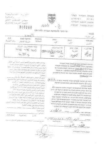
In an interview with ARIJ field team, owners of the demolished structures provided that they are living in Wa’r Al-Beik area since the year 1992, where they received demolition orders from the Israeli Army for the first time in July 23, 2011. Then on October 23, 2011, they received demolition orders for the second time before the Israeli bulldozers takes down their structures in the early morning of January 12, 2012, which resulted in displacing about 40 residents most of them are children. See photocopies of the Israeli military demolition orders and Map 1:

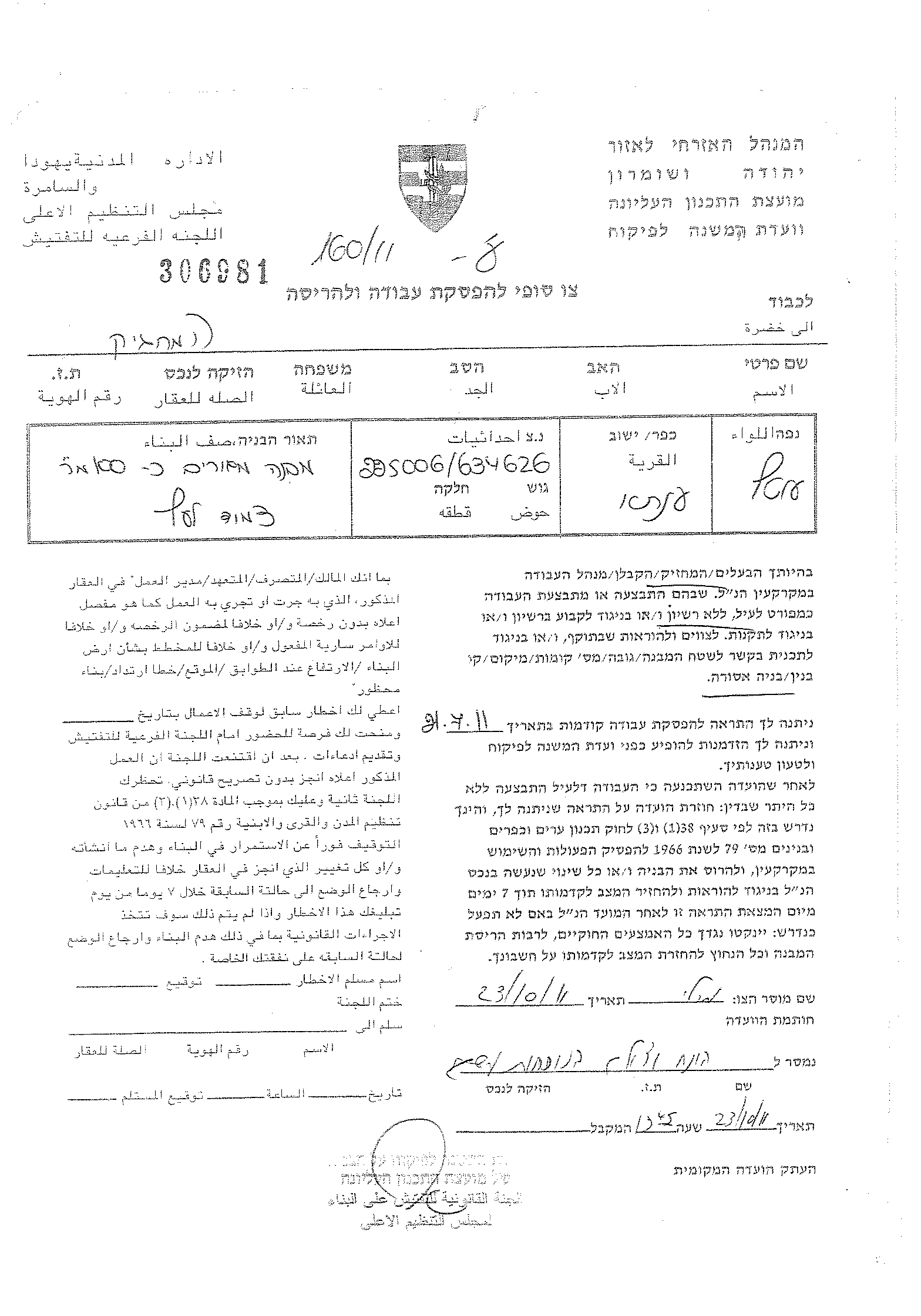

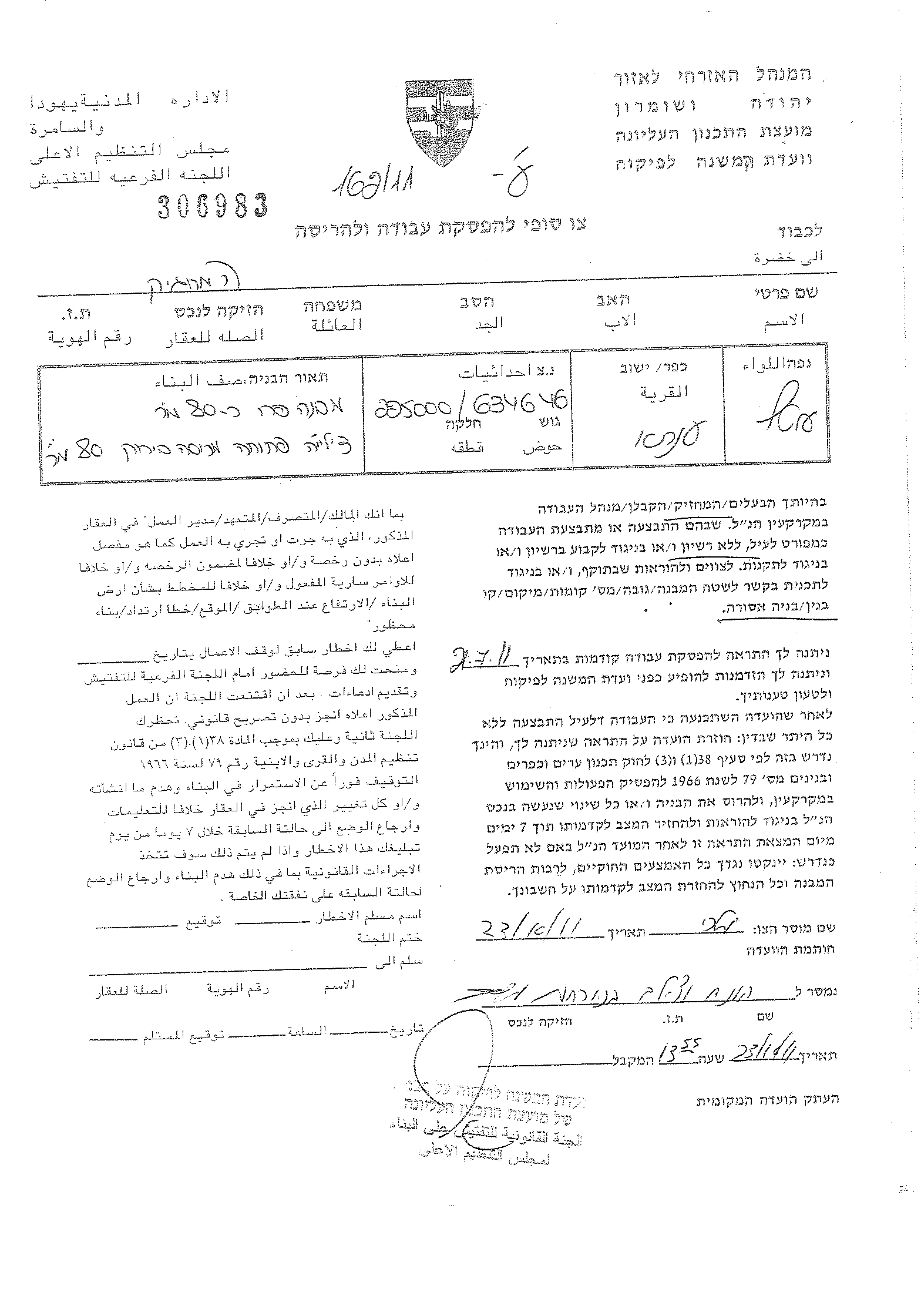
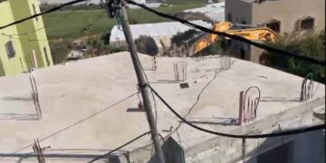
Photos 1-4: Photocopies of some of the military demolition orders
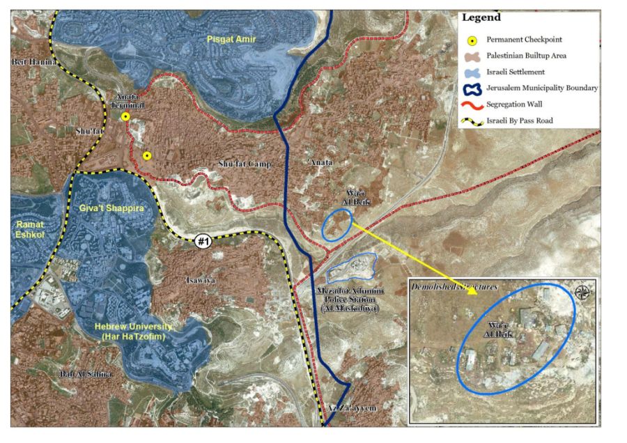
Map 1: the seven demolished structures in ‘Anata town
Moreover, on the same day (January 24, 2012), the Israeli Army bulldozers stationed in Al-Fuheidat area located nearby an Israeli military base called “’Anatot”, east of ‘Anata town and demolished a 100 m2 house owned by local resident Imad Omar Khalil Al-Lahalia and inhabited by 20 family members under the pretext of lacking proper authorization. Mr. Al-Lahalia indicated that he received a demolition order for his house on January 18, 2012 where, according to the military order, he has three days time to evacuate the house before it would be demolished. He also added that this is the second time the Israeli Army demolishes his house where they demolished his 180 m2 house, in the year 1996 under the same pretext. See Photos 1-4


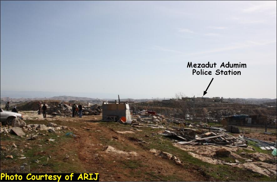
Photos 1-4: Part of the demolition that took place in ‘Anata town
‘Anata Town, location and Population
‘Anata, a Palestinian town located to the northeast of Jerusalem city and has a total area of 30603 dunums; including 1882 dunums (6% from its area) which constitute the town’s Palestinian built up areaThe town is located 4 km east of the Green Line (Armistice Line of 1949) and 5 km from Jerusalem city. It is bordered by Hizma village along with the illegal Israeli settlement of “Allon” from the north, Az-Z’aeim village from the south, Ramat Eshkol settlement from the southwest and Shu’fat town from the east.
The geopolitical Divisions of ‘Anata Town Lands
According to the Oslo IIInterim Agreement of 1995, which was signed between Israel and the PLO (Palestinian Liberation Organization) on September 24, 1995, the Palestinian Territory lands were classified into areas A, B and C designating varying levels of control. This classification has scattered the occupied Palestinian territory and turned it into isolated cantons; physically disconnected from each other. Accordingly, ‘Anata town lands were classified into areas B and C. Table 1 gives details of the land classifications in general and in ‘Anata town in specific:- See table 1 :
|
Table 1: The geopolitical divisions of ‘Anata Town Lands According to Oslo II Interim Agreement of 1995
|
||
|
Section 1
|
Areas Definition according to Oslo II Interim Agreement of 1995
|
|
|
Area A
|
the Palestinian Authority have complete autonomy over administrative and security issues;
|
|
|
Area B
|
the Palestinians have only civil responsibilities
|
|
|
Area C
|
Israel has full control over the area which constitutes 61% of the total West Bank area
|
|
|
Section 2
|
Area- Dunums
|
% From the village Area
|
|
Area A
|
0
|
0
|
|
Area B
|
918
|
3
|
|
Area C
|
29,685
|
97
|
|
Total
|
30,603
|
100
|
|
Source: ARIJ Database 2012
|
||
The Israeli Occupation practices in ‘Anata Town
It is worth pointed that ‘Anata town witnessed different aspects of Israeli colonial plans where 1525 dunums from its lands where confiscated for military usage under the pretext of security to build military bases.
Israel has also confiscated 2628 dunums from ‘Anata Town lands (8.5% oft he total town’s area) for building four Israeli settlements inside the village boundary. See table 2 below:
|
Table 2: Illegal Israeli Settlements inside ‘Anata Village Boundary
|
||||
|
No.
|
Settlement Name
|
Date of Est.
|
Population
|
Area inside the Village Boundary- Dunums
|
|
1
|
Neve Brat
|
1992
|
600
|
871
|
|
2
|
Kfar Adumim
|
1979
|
2127
|
751
|
|
3
|
Almon (Anatot)
|
1983
|
762
|
695
|
|
4
|
Allon
|
1990
|
520
|
311
|
|
TOTAL
|
*****
|
4009
|
2628
|
|
|
Source: ARIJ Database 2012
|
||||
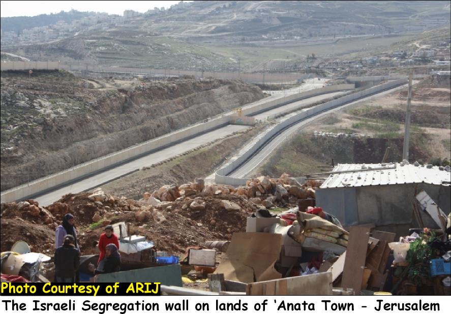
The Israeli Segregation wall plan in ‘Anata Town lands:-
According to the latest revised route of the Israeli Segregation Wall issued by the Israeli Ministry of Defense in April 2007, ‘Anata town is entrapped in an enclave along with Shu’fat refugee camp where both communities will be surrounded from all directions by the Israeli Segregation Wall with only one access to Jerusalem city, through Shu’fat Terminal. The wall, upon completion, will exclude the two communities from the center of life in Jerusalem city. It is worth mentioning that The Segregation Wall section that encircles ‘Anata and Shu’fat Refugee camp communities extends 23 km and will isolate 18,549 dunums (61%) from the total town’s lands (30,603 dunums).
To Conclude
The Israeli demolitions of the Palestinian houses conducted by the Israeli Occupation Army clearly violate the Universal Declaration of human rights, the International covenants as well as the rules of International Humanitarian Law:
-
Articles 53 & 147 of the Fourth Geneva Convention indicated that: Extensive destruction and appropriation of property not justified by military necessity and carried out unlawfully and wantonly. Is a grave breach of the Convention.
-
Hague Convention IV (18 October 1907): Convention Respecting the Laws and Customs of War on Land: Article (23): ‘To destroy or seize the enemy’s property, unless such destruction or seizure be imperatively demanded by the necessities of war;’
-
Convention (IV) relative to the Protection of Civilian Persons in Time of War. Geneva, 12 August 1949, Article 53: Any destruction by the Occupying Power of real or personal property belonging individually or collectively to private persons, or to the State, or to other public authorities, or to social or cooperative organizations, is prohibited, except where such destruction is rendered necessary by military operations.
-
Article 3 in the Universal Declaration of Human Rights reads that: states that ‘everyone has the right to life, liberty and security of person’.
-
Article 25 states that ‘(1) Everyone has the right to a standard of living adequate for the health and well-being of himself and of his family, including food, clothing, housing and medical care and necessary social services, and the right to security in the event of unemployment, sickness, disability, widowhood, old age or other lack of livelihood in circumstances beyond his control.’
:::::::::::__
[1] The population of ‘Anata town is 13,101 residents (PCBS 2012).
Prepared by
The Applied Reserach Institute – Jerusalem