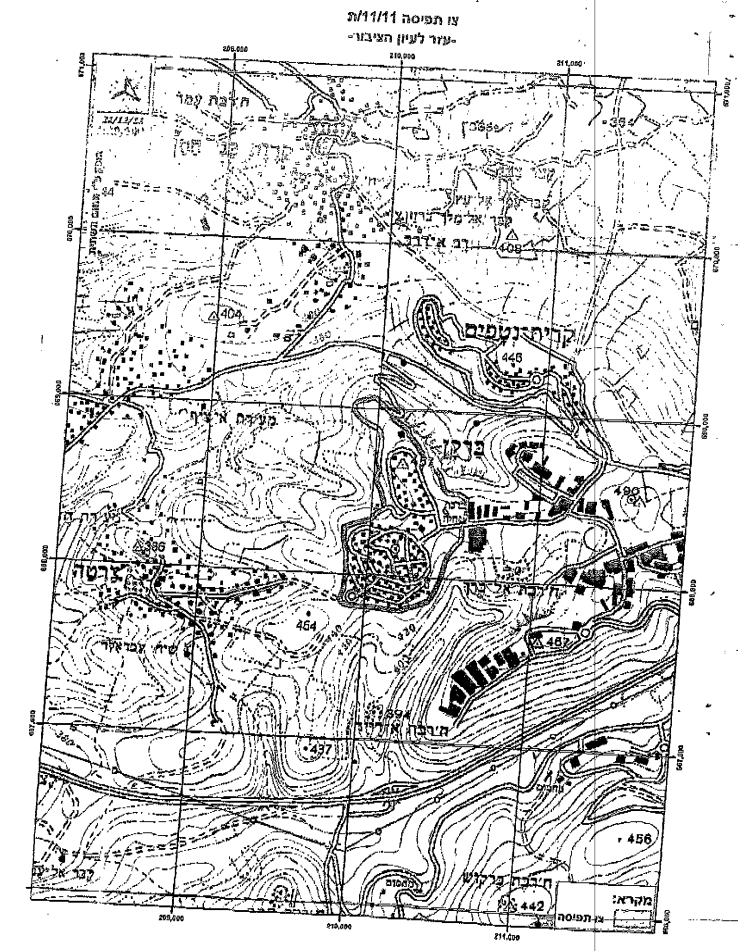
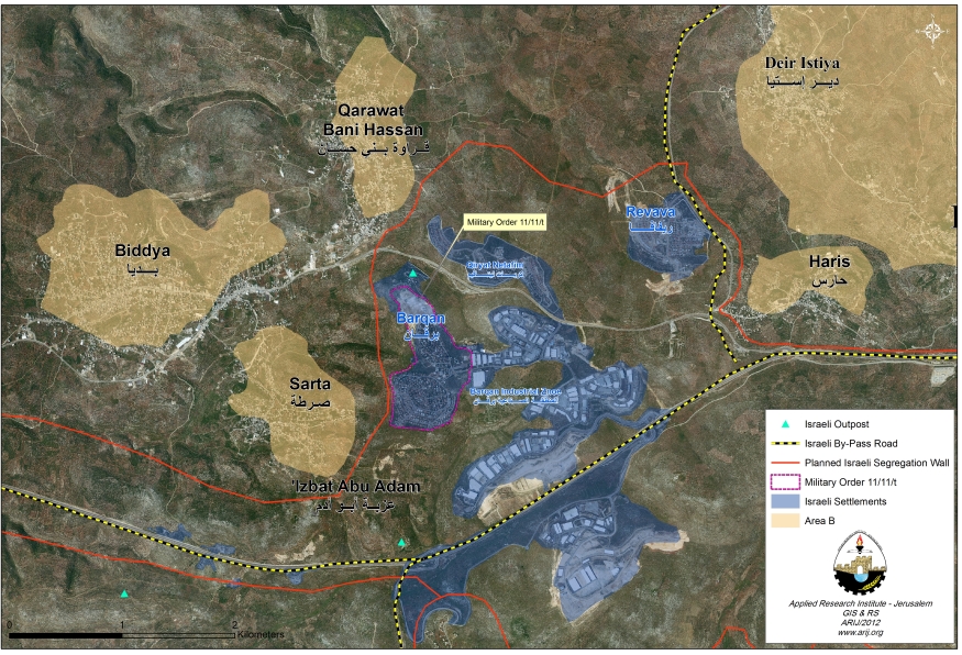
On January 16, 2012, the Israeli Army issued a new military order number (11/11/T) to residents of Sarta, Qarawet Bani Hassan and Haris villages in Salfit governorate. The order states the seizure of 21.3 dunums of Palestinian lands for imperative military purposes, to secure the settlement of Barqan, located within Ariel finger in Salfit Governorate. Residents of the aforementioned communities were given a period of 10 days from the date the order was issued to file their objections against the seizure order at the District Coordination Offices (DCO) in Efrayem. The area targeted in the military order is located in:
-
Haris Village : Basin no.2 / Khallet Hadida.
-
Qarawet Bani Hassan village: Basin no.3 / Sreibeh.
-
Sarta Village: Basin no.2 / Najeh Al Shami. See Annex 1: translation of the military order No. 11/11/T
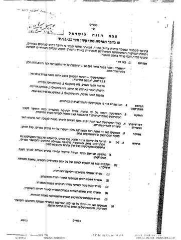
It is worth mentioning that only on February 23, 2012 that residents of the aforementioned communities received the seizure order, 42 days after the order was issued, which means that, the period set for objection against the military order (10 days) at Efrayem DCO already expired and Palestinian land owners in the three villages lost their right to object the military order as indicated. Photos 1, 2 & 3 are copies of the military order in Hebrew.


Photos 1-3: A copy of the Israeli MIlitary Order No. 11/11/T
|
Table 1: Palestinian communities affected by the establishment of Barqan settlement in Salfit Governorate
|
||||
|
No.
|
Village Name
|
Total Village Area (dunums)
|
Area Confiscated from Village
(dunums)
|
Percent from Village Boundary
|
|
1
|
Sarta
|
5609
|
130.3
|
2.3
|
|
2
|
Haris
|
8370
|
303.6
|
3.6
|
|
3
|
Qarawet Bani Hassan
|
9684
|
215.1
|
2.2
|
|
Total
|
23663
|
649
|
2.7
|
|
|
Source: The Geo-informatics department, ARIJ 2012
|
||||
An Analysis conducted by the Geo-informatics department, at the Applied Research institute (ARIJ), showed that a fence (consisting of barbed wires) already exists around the settlement of Barqan settlement in addition to that being built around Ariel finger, and that the military order was only issued to give legality to the already existing fence (consisting of barbed wires) which was set to secure the settlement of Barqan as indicated by the Chief Commander in the ministry of defense at the Israeli Civil Administration during the field visit conducted by the District Coordination Office in Efrayem to present the targeted lands. .
The Israeli Segregation Wall plan affects the Palestinian lands of Sarta, Haris and Qarawet Bani Hassan
The latest revised route of the Israeli segregation wall plan published on the Israeli Ministry of Defense’s website on April 30, 2007 shows that a wall is to encircle the settlements of Ariel, Revava, Qiryat Netafim, Barqan, Barqan Industrial zone and Ariel West Bank Industrial which constitute Ariel finger and annex them to Israel. The wall also affects the lands of Haris, Sarta and Qarawet Bani Hassan villages as it isolates a considerable portion of their areas within the western segregation zone (inside the wall) and seize them to Israel’s proper. The wall also affects a number of Palestinian communities nearby as it leads to the seizure of these lands and isolate them to become off access to Palestinians upon wall completion around Ariel finger. Table 2 gives details of the Palestinian communities affected by the construction of the wall around Ariel finger
|
Table 2: Palestinian Communities affected by the construction of the wall around Ariel Finger
|
||||
|
|
Palestinian Village Name
|
Lands Isolated within the western Segregation Zone (Inside wall) (dunums)
|
Total Village area (dunums)
|
Percent from Village Boundary
|
|
1.
|
Deir Istyia
|
17352
|
34102
|
50.9
|
|
2.
|
Haris
|
7550
|
8370
|
90.2
|
|
3.
|
Kifl Hareth
|
4582
|
9389
|
48.8
|
|
4.
|
Marda
|
3884
|
9051
|
42.9
|
|
5.
|
Salfit
|
6328
|
23078
|
27.4
|
|
6.
|
Farkha
|
70
|
5625
|
1.2
|
|
7.
|
Burqin
|
4054
|
12656
|
32.0
|
|
8.
|
Sarta
|
3531
|
5609
|
62.9
|
|
9.
|
Qarawet Bani Hassan
|
1596
|
9684
|
16.5
|
|
10.
|
Iskaka
|
150
|
5357
|
2.8
|
|
Total
|
49097
|
122921
|
39.9
|
|
|
Source: The Geo-informatics department, ARIJ 2012
|
||||
Conclusion:-
Israel continues to target Palestinian residents and their properties in all over the occupied Palestinian territory (OPT) in order to impose facts on the ground, to prevent local residents from building on their own lands in order to expand the adjacent illegal settlements and secure them. This in turn constitutes a grave breach of the International law rules and human conventions such as:
- Article 53 & 147 of the Fourth Geneva Convention of 1949 indicated that: ‘Extensive destruction and appropriation of property not justified by military necessity and carried out unlawfully and wantonly, is a grave breach of the Convention’.
- Moreover Art. 23 of the Hague Convention of 1907 also provides: ‘In addition to the prohibitions provided by special Conventions, it is especially forbidden to destroy or seize the enemy’s property, unless such destruction or seizure be imperatively demanded by the necessities of war’.
- Also under the Universal Declaration of Human Rights adopted and proclaimed by General Assembly Resolution 217 A (III) of, December 10, 1948, Article 17 reads: ‘No one shall be arbitrarily deprived of his property’. Which means it bans Israel from destroying or confiscating the property of the Palestinians at any case.
Annex 1: Translation of military order number (11/11/T)
|
Israel Defense Forces
Order to Seize lands n0 (11/11/T)
According to my authorities as a Military Chief Commander in the Region of Judea and Samaria, and as I believe that it is imperative for military reasons due to the special security situation in the region, I order the following:
1- In This Order: The ‘Map’ – signed in scale 1: 10, 000 and attached to the order is an essential part of this order.
The ‘Lands’ – An area of land which is 21.3 dunums marked in red in the map and are located in lands of:
2- I announce by that the above mentioned lands are seized for imperative military purposes.
3- The IDF seize the lands and an absolute control of the land is given to the Military Chief Commander of the Central Region through the Ministry of Defense Chief Officer in the Civil Administration Office.
4- Land Owners have the right to go to the District Coordination Office in Efrayem to get usage expenses and compensation.
5- Copies of this military order and the attached map are handed out to Land owners or to the District Co-ordination Office in Efrayem.
6A-1- This military order is to be notified to Land Owners or those who act on behalf of them by posting it at the District Coordination Office in Efrayem and dispersing it on the lands by any possible mean.
5A-2: The date of the field visit conducted by the District Coordination Office in Efrayem to present the lands.
5B- Copies of the military order and the attached map are available for interested parties at the following places:
5C- Copy of the military order and the attached map is set at Efrayem District Coordination Office Board for 10 days from the issuance date of the military order, as mentioned in Part (5A).
6- Land owners or those who act on behalf of ownership have the right to object the military order in 7 days from the date of the field visit as mentioned in Part (5A) above through the District Coordination Office in Efrayem or at the Office of the juridical advisor in the region.
7- This order is valid until 31/12/2014.
8- This order is called: ‘Order to seize lands n0 11/11/T (Judea & Samaria).
Avi Mezrachi
Chief Commander of the Israel Defense Forces in Judea & Samaria -Signature January 16, 2012
|
Prepared by
The Applied Research Institute – Jerusalem
ARIJ