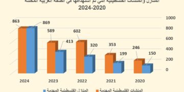
Violation: Israeli occupation forces demolished 9 commercial structures under construction in Al Ouja.
Date: January 23, 2012.
Details:
The area of Al Ouja, located east of the city of Jericho, has witnessed on January 23, 2012, a new wave of demolitions that targeted 9 commercial storage structures located parallel to the By-Pass Road 90 under the pretext of being built “without permit”. The demolitions are part of the institutionalized Israeli policy aimed transferring the Palestinians from the Jordan Valley and replacing them with Israeli colonists. Other tools used to achieve this goal include violence carried out by colonists under the watchful eye and encouragement of the occupation forces while providing enormous budget to make colonization in the Jordan Valley a daily fact of life.
The following table provides additional information of the victims of the recent demolition in Al Ouja
|
Name
|
Family Members
|
No. of Children
|
Type of Structure
|
Notes
|
|
Diab Abdel Hamid Njoom
|
8
|
4
|
Under-construction commercial shop.
Area = 12 m2
|
Received a Stop Work Order earlier.
|
|
Fakhri Al Abdellah Njoom
|
8
|
5
|
||
|
Nayef Al Abdellah Njoom
|
5
|
3
|
||
|
Faisal Hasan Njoom
|
9
|
6
|
||
|
Ibraheem Hasan Njoom
|
7
|
5
|
||
|
Moh’d Abdel Rahman Njoom
|
3
|
1
|
||
|
Jaser Abdel Rahman Njoom
|
6
|
4
|
||
|
Yaser Abdel Rahman Njoom
|
7
|
2
|
||
|
Shadi Hasan Salameh
|
5
|
3
|
||
|
TOTAL
|
58
|
33
|
|
|
Source: Israeli Violation Monitoring Unit – LRC


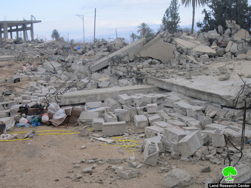
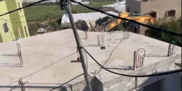
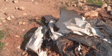
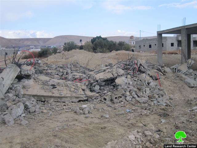
Pic.1-4: Scenes of the destruction caused by the demolition of the commercial shops in Al Ouja.
It has to be pointed out that more than 20 structures (agricultural and housing shelters) have received demolition orders in the area of Al Ouja from the so-called Israeli “Civil Administration” under the pretext of building “without a permit”.


The Village of Al Ouja:
Al Ouja is a village in the Governorate of Jericho. It is located 12 kilometers north east of the City of Jericho on the eastern highway linking Bisan with the Dead Sea. Its population is about 4,132 most of them are from Arab Al Ka’abneh. The total area of the village of 106.900 dunums. It borders the village of Fasayel northwards, Al Nuwei’ama southwards, the Jordan River eastward and the mountains of Ramallah in the west. Its resident work in farming especially due to the presence of a number of water wells in the area. About 3,000 dunums are used for agricultural purposes in the area.
Israeli occupation forces have controlled most of the agricultural lands of Al Ouja. The lands were used for the establishment of colonies in addition to placing a number of military bases in the area due to its close proximity to the Jordanian borders. As such, more than 20,000 dunums of the lands of the village (known as Al Sahl, located parallel to the Jordan Valley) has been declared as “Military Zone” and, as such, no Palestinian access is allowed.
Also, in the year 1976 the colony of Nutaf was established on the villages’ lands. In the year 1977, the colony of Nura’an and in the year 1979 the colony of Na’omi were established. The colonies of Tomer and Natif Jiddad were later established while military towers have surrounded the village from all directions.
Prepared by
The Land Research Center
LRC
The Land Research Center
LRC