
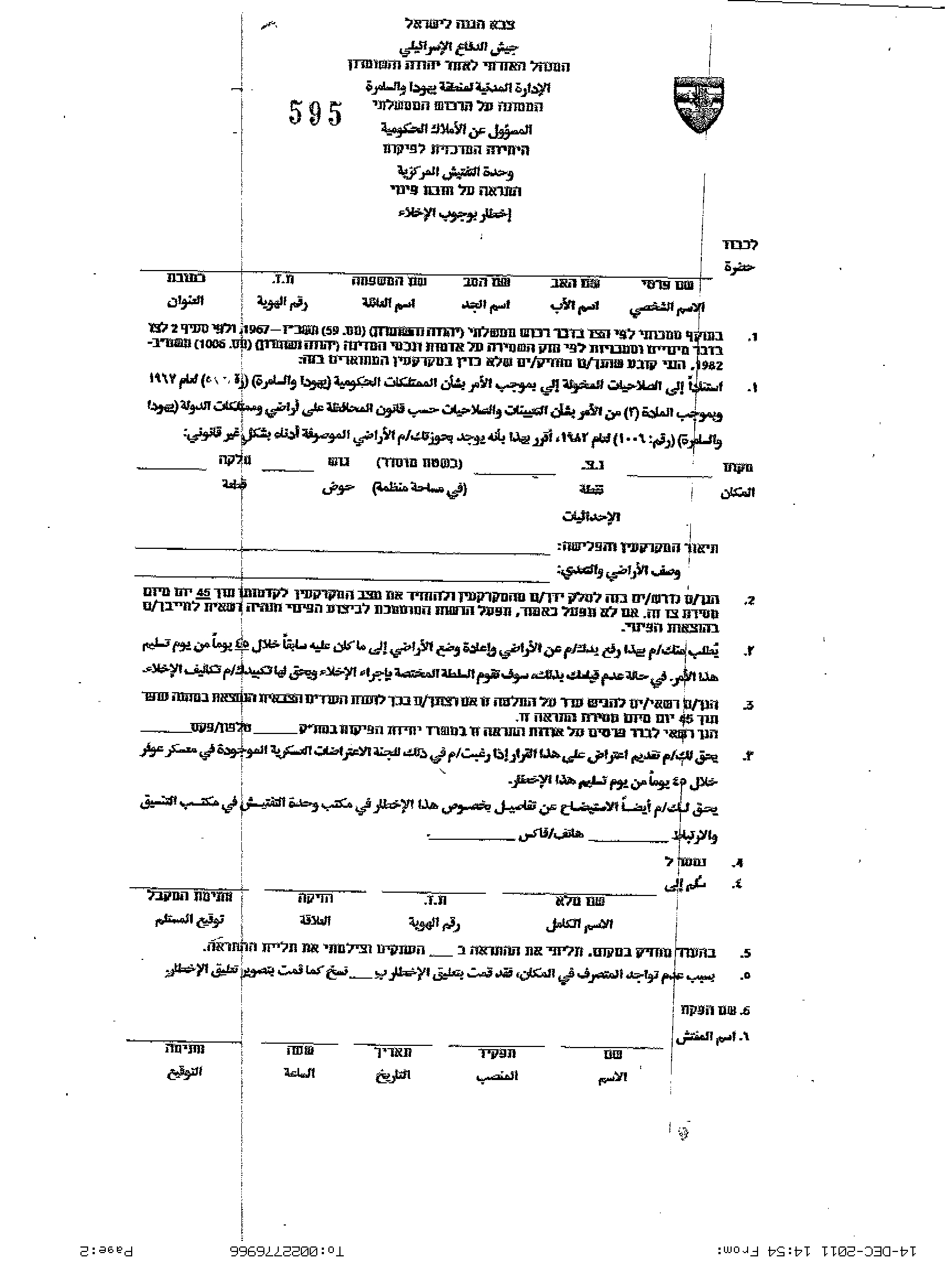
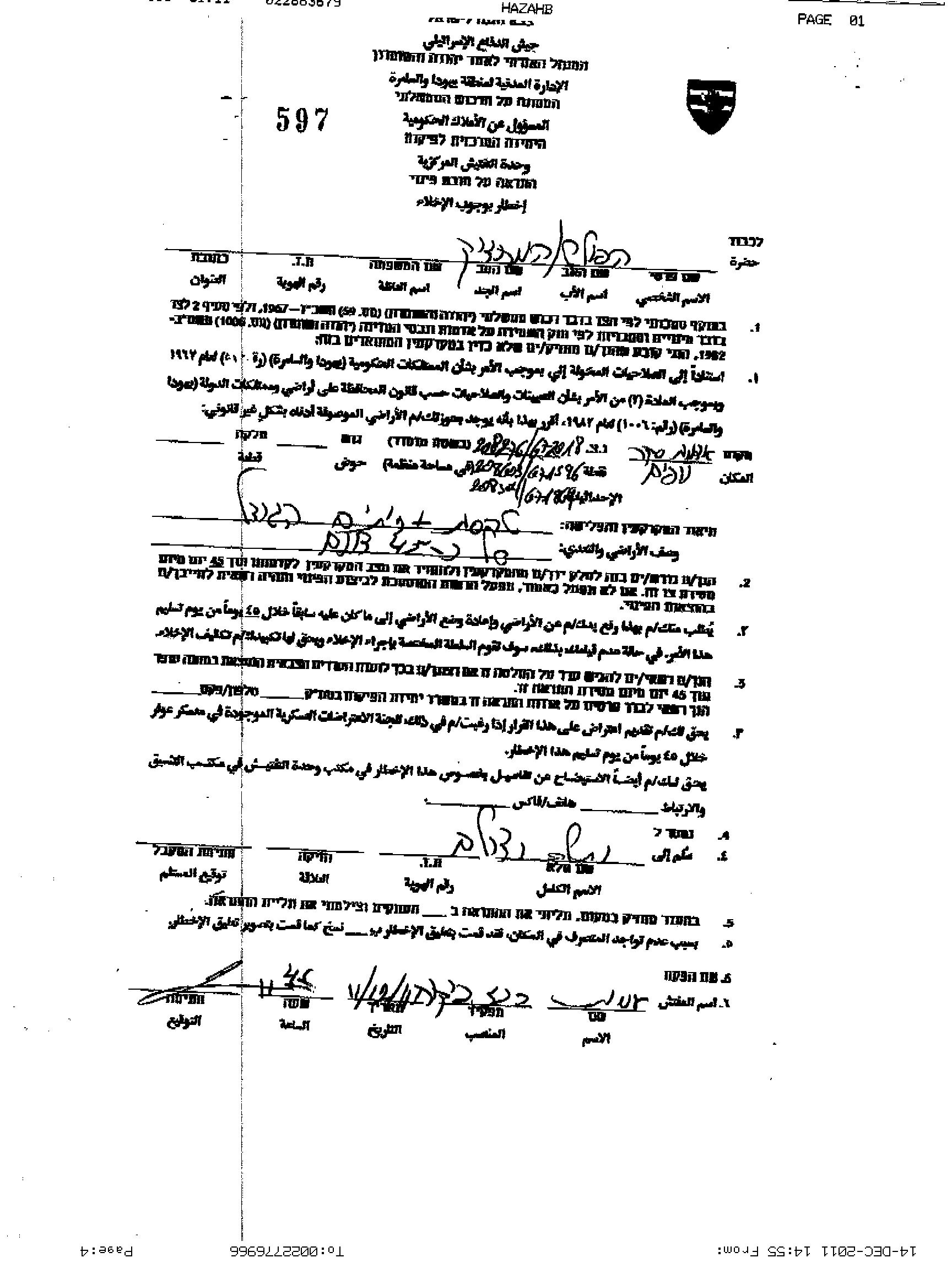
On December 12, 2011, the Israeli Occupation Army notified a number of Palestinian farmers from Qarawet Bani Hassan village west of Salfit to evacuate vast areas of agricultural lands west of the village, in the area known to locals as Bi’r Abu Ammar (Abu ‘Ammar Well) under the pretext of being classified as ‘State Lands’. The military orders hold numbers 594, 595, 596, 597 and 598 and target the following owners Yousef Sa’ed Mer’i , Samih Ibrahim Assi , Khader Ismail Salum , Saber Mustafa Mer’i and Nader Mustafa Mer’i. It is worth mentioning that owners of the lands were given 45 days (as stated in the military order) to file objections against the military orders at the office of Israeli Civil Administration in Ofer settlement. It is worth to mention that few years ago the targeted lands were reclaimed and cultivated with olive trees.
An analysis conducted by the Applied Research Institute – Jerusalem (ARIJ) of the military orders targeting the lands of Qarawet Bani Hassan village showed that more than 160 dunums are to be confiscated from the village lands. Table 1 below gives details of the military orders and the area they target:-
|
Table 1: The Israeli military orders targeting Qarawet Bani Hassan village lands
|
|
|
Military Order No.
|
Area in Dunums
|
| 594 |
50
|
| 595 |
47.2
|
| 596 |
3.4
|
| 597 |
27.3
|
| 598 |
8.8
|
|
23.7
|
|
|
Total
|
160.4
|
|
Source: the municipality of Qarawet Bani Hassan
|
|


Map 1: the location of the threatened lands in Qarawet Bani Hassan village
Qarawet Bani Hassan: Location & Population
A Palestinian village located 5.8 kilometer northwest of Salfit city and has a population of 4700 (PCBS 2010). Qarawet Bani Hssan total village boundary is 9684 dunums, 507 dunums which constitute the built up area. It is bordered by Kifel Haris, Harris, Deir Estiya and Qurra villages from the east, Saniryia village from the west, and from the north, Kedumim settlement bloc and Ariel settlement bloc from the south.
The Geopolitical status of Qarawet Bani Hassan Village
According to the Oslo II Interim agreement that was signed in September 1995 between the Palestinian Liberation Organization and Israel, the Occupied Palestinian Territory had been classified into areas ‘A’, ‘B’ and ‘C’; where in areas classified as ‘A’, the Palestinian National Authority (PNA) have complete autonomy over administrative and security issues. In areas classified as ‘B’, Palestinians have full control over the civil administration and Israel continues to have overriding responsibility for security; while areas classified as ‘C’ are those lands where Palestinians have responsibility for civil life such as economics, health, and education; while, Israel retains full control over security and administration related to the territory.
Under the signed agreement, Qarawet Bani Hassan village lands are classified into areas B, C. where; Area B constitutes 10.7% (1040 dunums) of the total area of the village and Area C constitutes 89.3% (8644 dunums) of the total area of the village and includes all the agricultural lands and open spaces. See Table 2:
|
Table 2: Classification of Lands in Qarawet Bani Hassan village according to Oslo II Agreement of 1995
|
||
|
Classification
of Area |
Area in dunums
|
% of the Village’s total area
|
|
Area A
|
0
|
0
|
|
Area B
|
1040
|
10.7
|
|
Area C
|
8644
|
89.3
|
|
Total Area
|
9684
|
100
|
Source: Geo-Informatics Department – ARIJ 2011
Throughout the years of the Israeli occupation in the Palestinian territory, Israel seized and confiscated 411 dunums of Qarawet Bani Hassan village lands, 13.9% of the total village area to establish 2 illegal Israeli settlements which are inhabited today by more than 2200 Israeli settlers. The two settlements are located within the Ariel settlement bloc.Table3
|
Table 3: Israeli Settlements established on land of Qarawet Bani Hassan village
|
|||
|
Settlement Name
|
Establishment
Date
|
Settlers
Pop. (2009) |
Lands confiscated from Qarawet Bani Hassan village
(dunum) |
|
Barqan
|
1981
|
1513
|
215
|
|
Kiryat Netafim
|
1982
|
706
|
|
|
Total
|
—
|
|
411
|
|
Source: Geo-Informatics Department – ARIJ 2011
|
|||
Qarawet Bani Hassan village and the Israeli Segregation Wall plan
Qarawet Bani Hassan is one of the Palestinian villages that faced the threat of the Israeli segregation wall. According to the Israeli revised wall map that has been published on the Israeli Ministry of Defense website on April 30, 2007, the segregation wall will extend a length of 3 km on lands of Qarawet Bani Hassan and consequently will cause the isolation of 1596 dunums (16.5% of the total village area), including the open spaces and agricultural lands in the village. See table 4:
|
Table 4: Isolated landuse and landcover for Qarawet Bani Hassan village – Salfit Governorate
|
|
|
Land classification of Al Khader Village isolated lands
|
Area (Dunum)
|
|
Agricultural lands
|
711
|
|
Open Space
|
466
|
|
Artificial Surfaces
|
38
|
|
Israeli Settlement
|
419
|
|
Total Area
|
1596
|
Source: Geo-Informatics Department – ARIJ 2011
The Israeli Occupation practices in Qarawet Bani Hassan
On April 11, 2010 the Israeli Occupation Forces issued an order to halt the construction work of an agricultural road, 1.3 km long, that links the village with B’ir Al Nuweitif area (Al Nuweitif well). The road was financed by the Palestinian National Authority is designated to serve more than 40 Palestinian farmers. The Israeli pretext was that the construction of the road started without the approval of Israeli Occupation authorities due to its location in area ‘C’ which according to the Oslo II Interim agreement of 1995, falls under the full Israeli control.
later on November 24, 2010 the Israeli Occupation Army along with military bulldozers raided the western part of Qarawet Bani Hassan village, in the area known as ‘Bi’r Abu Ammar’ (Abu Ammar well) and ‘B’ir Nuwietef’ (Nuweitef well) and targeted Al Horiya road (Freedom road) and a number of agricultural projects in the area. Al Horiya road (Freedom road) project was funded by the Palestinian Ministry of Finance at an estimated of USD 350,000. The project consisted of opening and paving the road in addition to the placement of metal barriers on both sides and chairs for waiting.
It is worth to point out that the Israeli Occupation justified their act by claiming that the structures were constructed without building permits issued by the Israeli Civil Administration for the road to be constructed. Estimated losses of the first demolition wave are around 35 $(132.000 NIS) and are as follows:
-
Saber Mir’i: The Israeli Occupation Army demolished retaining walls, Plastic house, destroying water pipes and uprooting fruitful trees, his losses was estimated around USD 19000.
-
Amin Ahmad Abd Salum: : The Israeli Occupation Army demolished 50 meters long retaining walls , estimated loss; USD 4000.
-
Khader Ismail Salum: The Israeli Occupation Army demolished 70 meters long retaining walls , estimated loss; USD 5500.
-
Mohamad Amer Rayan: The Israeli Occupation Army demolished 50 meters long retaining walls , estimated loss; USD 4000.
-
Sameh Ibrahim Assi: The Israeli occupation bulldozers demolished 40m long retaining walls. Estimated loss is USD 3500.
Estimated losses of the second demolition wave in Qarawet Bani Hassan village was digging holes in the freedom road every 20 meters in addition to the destruction of all the accessories.
To conclude,
The continuous Israeli plan to take control over Palestinian lands is part of a political maneuver to reinforce an Israeli hold over the territory, and to put an end to the peace efforts for a “two state solution”. The Israeli unilateral actions conducted by the Israeli government in occupied Palestian terrory in general constitute a grave breach of the International law rules and human conventions:-
ARTICLE 53 of the fourth Geneva convention states that: ‘ Any destruction by the Occupying Power of real or personal property belonging individually or collectively to private persons, or to the State, or to other public authorities, or to social or cooperative organizations, is prohibited, except where such destruction is rendered absolutely necessary by military operations.’
Article 147 of the Fourth Geneva Convention states: Grave breaches to which the preceding Article relates shall be those involving any of the following acts, if committed against persons or property protected by the present Convention: willful killing …willfully causing great suffering or serious injury to body or health …. Extensive destruction and appropriation of property not justified by military necessity and carried out unlawfully and wantonly.”
The General assembly resolution 217A (III), article 17, para 2 of the Universal Declaration of Human Rights of 1948 states that ‘No one shall be arbitrarily deprived of his property.’
——————————————————————————-
[1] Article of Convention (IV) relative to the Protection of Civilian Persons in Time of War. Geneva, 12 August 1949.
[2] Convention (IV) relative to the Protection of Civilian Persons in Time of War. Geneva, 12 August 1949.
[3] Universal Declaration of Human Rights, G.A. res. 217A (III),
Prepared by:
The Applied Research Institute – Jerusalem
The Applied Research Institute – Jerusalem


