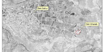
On the 14th of October 2011, hundreds of Israeli settlers and dozens of vehicles from Efrat settlement stormed Palestinian lands in Khallet An Nahleh (An Nahleh Hamelt) and Shu’ab Salman areas in Artas village from several directions, and tried to take over the land in an attempt to expand the area of Efrat Settlement. The targeted area is also known to the Israelis by ‘The Eight Hill of Efrat’ or ‘Giv’at Ha’eytam Hill’ and is located on a strategic hill, in the Gush Etzion settlement bloc and spans over 1700 dunums. It is an unbuilt hill that Israeli settlers are trying to control in order to add it to the already existing sevenhills located within the jurisdiction of Efrat settlement.
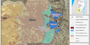
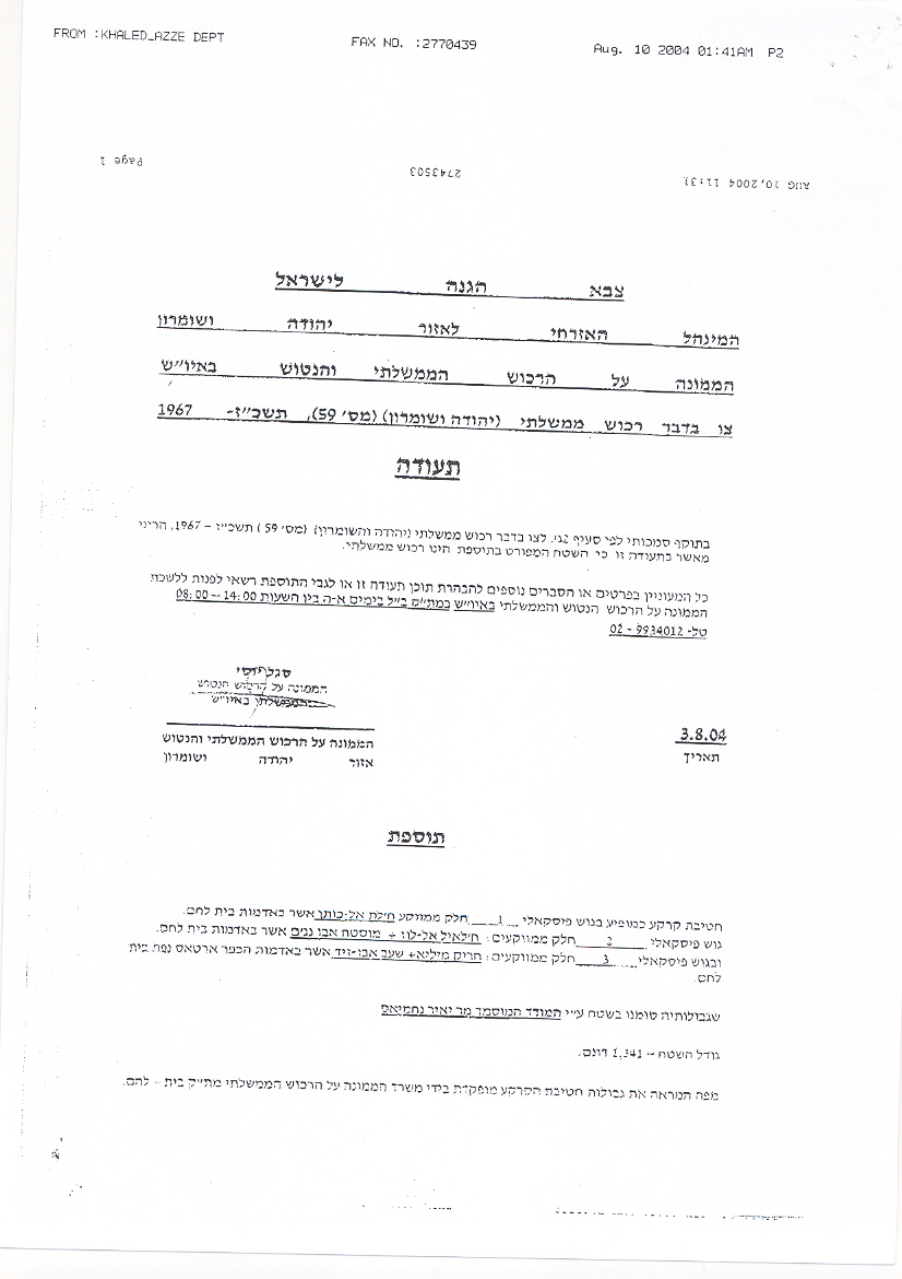
It is worth mentioning that the area of Khallet An-Nahla and Shu’ab Salman was targeted with a military order[(Order regarding state property ‘Judea & Samaria’ (No. 59) 5727-1967) issued by the Israeli Custodian of absentee Properties in 2004 declaring 1341 dunums of lands as ‘State Lands’. Residents of the targeted areas filed petitions to the Israeli court to prevent the confiscation of their lands as the lands constitute a major source of income to them. In February 2009, the court responded to land owners by rejecting 8 out of 9 petitions filed to the court and declared the lands as ‘State Property’ where owners were denied entry to the land and prevented from using the land for any purpose or under any circumstances. See Copy of military Order


Map 1: the military order stating the confiscation of Giv’at Ha’eytam hill
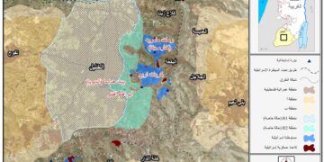
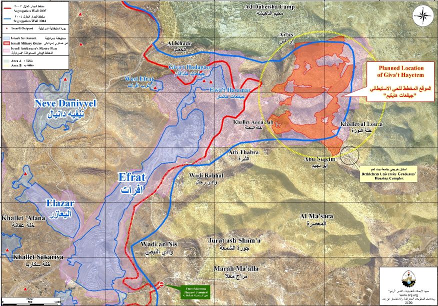
An analysis conducted by the Applied Research Institute – Jerusalem (ARIJ) to the Israeli military order showed that the area targeted is 1700 instead of 1341, an increase of 359 dunums than the area stated in the military order. The analysis also showed that the targeted area is located within the master plan of Efrat settlement and is set outside the planned wall route which was published on the Israeli Ministry of defense website on April 20076. It is worth mentioning that the plan on the Giv’at Ha’eytam hill includes the construction of 2500 housing units.
The plan in Giv’at Ha’eytam Hill
Since Israel sanctioned the construction of the Segregation Wall in 2002, it has been subjected to several changes that aim to benefit the Israeli settlements rather than the Palestinian population. Each change has resulted in an increase in the length of the Wall and an expansion of the segregated area. In the case of Efrat settlement and the Giv’at Ha’eytam hill, the wall map of 2004 showed that the hill was set inside the area to be annexed to Israel (Behind the 1949 Armistice Line, Green Line) upon wall completion. Later in 2005, when the Israeli army made changes in several sections of the segregation wall in the West Bank, the Giv’at Ha’eytam hill was set outside the wall route and no longer to be annexed to Israel. The settlers plan to take over Giv’at Ha’eytam hill is to force the Israeli Government to change the route of the segregation wall (that is undergoing construction) in that area so that it would include the Giv’at Ha’eytam hill within its plan so that the hill won’t be given back to the Palestinians under any future agreement with the Israelis.
To conclude:-
The growing influence of right-wing movements in the West Bank has encouraged the Israeli settlers to ignore the Israeli army and police orders and reject any governmental resolutions. This feeling of power, push the settlers to even attack Israelis who dissent with their opinions and Israeli soldiers as well.
::::::::::::::___
[1] Rimon, Te’ena, Gefen, Dekel, Zayit, Dagan, Tamar
[2] Military Order #59 (1967?) – establishes the Israeli Military-appointed position of ‘Custodian of Government Property’ to take over land owned by the Jordanian Government. Also, allows the ‘Custodian of Government Property’ to appropriate land from individuals or groups by declaring it ‘Public Land’ or ‘State Land’, the latter which it defines as land that was owned or managed by, or had a partner who was an enemy body or citizen of an enemy country during the 1967 war (amended by M.O.1091).
[3] In 1991, the Israeli Civil Administration issued master plans for all Israeli settlements in the West Bank which include the Future area designated for future settlement expansion.
[4]Settlers: Netanyahu worse than Olmert
Gush Etzion settlers resume battle for Jewish control over Givat Eitam. Efrat official: We expected PM to continue West Bank construction; we got the exact opposite
Gush Etzion settlers resume battle for Jewish control over Givat Eitam. Efrat official: We expected PM to continue West Bank construction; we got the exact opposite
[5] to annex the Gush Etzion settlement Bloc to Israel
Prepared by: