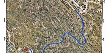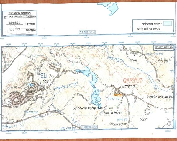
On June 26, 2011, the Israeli Civil Administration of Judea and Samaria delivered a declaration to confiscate 189 dunums under the pretext of State land, from the lands of Qaryout Village, located south of Nablus City, at the northern part of the West Bank. According to the declaration, Palestinian owners of the targeted lands have 45 days to appeal against the declaration. See interview with Qaryout councilman and copies and location of the declaration from the Israeli Civil Administration regarding the State Land.


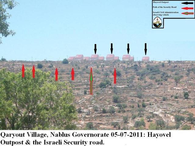
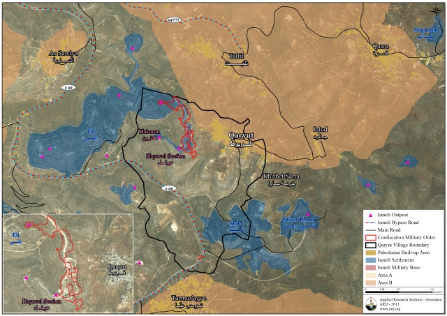
The targeted land in the marked in the declaration in lined to be officially declared “State Land” cover the location area of the outpost Giva’t Hayovel, which was established in 1998 to be what the Israeli calls an additional neighborhood to the standing westward settlement ELI. It exists along with part of the Israeli settlement Eli within Qaryout village boundary. Currently, the outpost has 17 permanent homes and 30 caravans in transition to become actual residential structures.
the declaration will pave the way to give an official status to the outpost Hayovel to become an official part of Eli settlement in spite of the 2005 report on the outpost status (the Sasson report), which stated that the outpost Hayovel was built private Palestinian lands, hence deemed illegal and must be dismantled as obligated under the 2003 international ‘road-map’ peace plan but that did not stop the Israeli Prime Minister Benjamin Netanyahu and Defense Minister Ehud Barak to go about it otherwise.
Israeli utilized techniques to grab Palestinians’ lands
The targeted lands for confiscation are all private lands owned by Palestinians, however, the pretext used by the Israeli Civil Administration to facilitate control of the land to the custodian of the absentee property was a disclosure as they activated an old law that goes back to the year 1858, to the time of the Ottoman Empire ruling time of the area.
Since the Israeli occupation of 1967, Israel has used various laws and a mixture of legal and bureaucratic procedures in order to control West Bank lands, to realize its end goal of establishing settlements and secure auxiliary land for their future expansion. Accordingly, and for the most parts, the Israeli occupation employed five main techniques:
- seizure for military purposes;
- declaration of state lands;
- seizure of absentee property;
- confiscation for public needs;
- initial registration,
Hence, Israel has managed to grab take some 50% of the West Bank lands in the West Bank, denying the Palestinian from using them.
The targeted lands for confiscation are all private lands owned by Palestinians, however, the pretext used by the Israeli Civil Administration to take control of the land was a disclosure even for the Israelis who invoked an old “law code” that goes back to the year 1858, to the time of the Ottoman Empire ruling time of the area, which basically considers all lands as “State Land” unless one can prove otherwise, and for that to happens; the land must be cultivated for at least ten consecutive years before it maybe registered as a private land, and if the land is not cultivated for a continued period ranging between 3 to 10 years then the land may become the property of the state; in the case to those who introduced the law; it becomes the property of the Ottoman State. However, the Israeli occupation has restrictively and systematically denied Palestinian to access or utilizes their land for continuous periods of time using other pretexts; mostly “security”, upon which Palestinians did not have the ability to use their lands at well at all time. Using this law, Israel confiscated more than 900,000 dunums from the West Bank lands, on parts of which the Israelis built at least 90 settlements out of 199 exist in the West Bank.
Qaryout Village:
Qaryout is an agricultural habitant Palestinian village located about 26 Km south east of Nablus City. It spread on 7483 dunums, of which 9.2% (691 dunums) classified as Area B, and the remaining 90.8% (6792 dunums) classified as Area C. It has a population of 2500 people (according to the village council).
Qaryout is surrounded by illegal settlements Eli and Hayovel outpost from the west and Shilo from east, part of which are constructed on the village lands. Table 1 shows the Israeli Settlements surrounding Qaryout village, in Nablus Governorate and related information. See maps 1&2
|
Table 1: The Israeli Settlements surrounding Qaryout village, in Nablus Governorate
|
||||
|
Settlement/ outpost
Name
|
Population
|
Year
Established
|
Total Area
(dunums)
|
Of which from
Qaryout village
|
|
Eli
(including Hayovel outpost
|
2900
|
1984
|
3258
|
596 dunums
(7.9%)
|
|
Shilo
|
2303
|
1978
|
1364
|
510 dunums
(6.7%)
|
|
Total
|
5203
|
|
4622
|
1106 dunums
(24%)
|
Source: GIS unit / ARIJ 2011

Maps 1&2
Prepared by:
The Applied Research Institute – Jerusalem