On the 28th of February 2011, the Israeli municipality of Jerusalem, delivered demolition orders to a residential complex called Al Umarra’ Tower complex (Burj Al Umarra’ in arabic) in Beit Hanina city north of Jerusalem city. The orders stated that the building is illegal and it will be demolished after ten days from the date the order was issued. One of the residents reported that he found the order hung on the door of his apartment.
The threatened structure is a building of 5 floors and one roof and is a home to 22 Palestinian families. The pretext of the demolition order is the illegal status of the structure, where the Israeli Authorities say that the two additional floors (4 & 5) and the roof were built illegally and that the violation fees weren’t paid by owner of the housing complex. Residents of the structure said that the owner has been paying the violation fees since 2006, and that the structure has an official building permit for three floors. Residents also added that four months ago they found out that the building is threatened of demolition according to an order issued by the Israeli Municipality of Jerusalem on the 27th of March 2006 despite the fact that the owner of the building (Muhammad Hillal Al Najjar), who lives abroad, has been paying the violation fees. Table 1 gives details of the 22 Palestinian families who reside in Al Umarra’ Tower complex;
|
Table 1: Al Umarra’ Tower (Burj Al Aumara’) Housing Complex residents
|
||
|
No.
|
Owner Name
|
No. of family members
|
|
1
|
Abed Al Kareem Al Alami
|
12
|
|
2
|
Alice & Fadwa Attallah
|
2
|
|
3
|
Bassam Al Rimawi
|
6
|
|
4
|
Diana Hanna Khoury
|
3
|
|
5
|
Farah Jamil Razzouk
|
3
|
|
6
|
George Basil Siryani
|
4
|
|
7
|
Iz Al Din S’ied
|
6
|
|
8
|
Jamil Hanna Razzouk
|
5
|
|
9
|
Jamil Mustafa Abu Al Nada
|
6
|
|
10
|
Jammal Mustafa Abu Al Nada
|
6
|
|
11
|
Jimmy Nammour
|
8
|
|
12
|
Laila ‘Urabi Kurdya
|
6
|
|
13
|
Maher Da’oud Ramadan
|
8
|
|
14
|
Mazin Omar Abu Libdeh
|
7
|
|
15
|
Nader Ameer Dana
|
6
|
|
16
|
Nazli Karam
|
2
|
|
17
|
Rasha Judeh Mina
|
2
|
|
18
|
Sameh Shtat
|
7
|
|
19
|
Sami Jammal Bajjali
|
8
|
|
20
|
Su’ad Mahmoud Tamimi
|
6
|
|
21
|
Yousef Khader Odeh
|
6
|
|
22
|
Zidan Nimer Al Hussieni
|
10
|
|
Total
|
138
|
|
|
Source: residents of (Burj Al Umarra’)
|
||
Also on the 7th of March 2011, a similar case occurred to another residential complex in Beit Hanina city north of Jerusalem. The complex is called Al Rasheed Tower and is owned by Muhammad Hillal Al Najjar, owner of Al ‘Omara Tower residentiala complex (Burj Al Omara’). The Israeli Occupation Municipality team delivered the demolition orders to families living in the complex and gave them 10 days to vacate the complex in order to demolish it under the pretext of lacking permits. The Complex is composed of four floors and one roof, where three of these floors have building permits, while the remaining floor was built without a building permit. Al Rasheed Tower is (Burj Al Rasheed) is located near Al ‘Omara Tower (Burj Al Omara’), and is under the same threat, where the owner said that he already paid the building violation fines that he was ordered to pay by the Israeli Municipality of Jerusalem, while the Municipality denies that and claim that the complex has large accumulating amounts of building violations. Table 2 gives details of the number of families living in Ar Rasheed tower (Burj Al Rasheed), the number of apartments and the area of each apartment.
|
Table 2: Al Rasheed Tower (Burj Al Rasheed) Housing Complex residents
|
|||
|
No.
|
Resident Name
|
Number of Residents
|
Apartment Area
|
|
1.
|
Abu Libdeh Family
|
8
|
155 m²
|
|
2.
|
Ahmad Qarra’ien
|
6
|
145 m²
|
|
3.
|
Ali Fakhri Al Haj
|
4
|
145 m²
|
|
4.
|
Fadi Abu Mannah
|
4
|
114 m²
|
|
5.
|
Haytham Yaghmour
|
5
|
155 m²
|
|
6.
|
Iyad Tayyem
|
6
|
145 m²
|
|
7.
|
Izdihar Al Najjar
|
2
|
155 m²
|
|
8.
|
Izdihar Al Najjar
|
-0- Partly demolished
|
113 m²
|
|
9.
|
Mousa Al Qawasmi
|
4
|
145 m²
|
|
10.
|
Muhammad Abu Harthya
|
4 (currently abroad)
|
145 m²
|
|
11.
|
Rafieq Al Miqdadi
|
5
|
113 m²
|
|
12.
|
Taha Ali Al Najjar
|
3
|
113 m²
|
|
13.
|
Taha Ali Al Najjar
|
3
|
113 m²
|
|
14.
|
U’thman Fakhri Al Haj
|
4
|
145 m²
|
|
15.
|
Zahya Ghyada
|
6
|
155 m²
|
|
Total
|
64
|
2056 m²
|
|
|
Source: Residents of Al Rasheed Residential Tower (Burj Al Rasheed)
|
|||

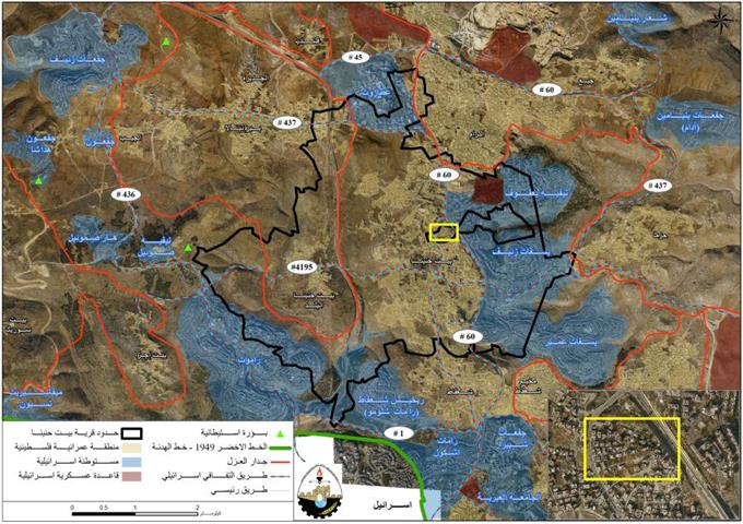
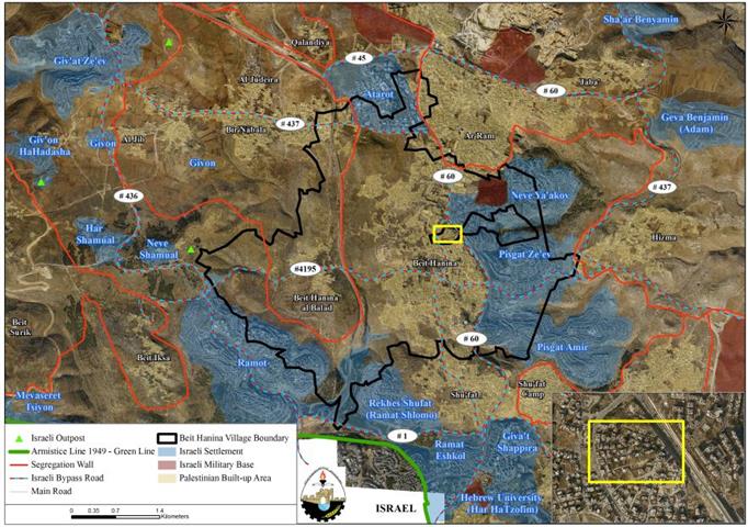
Map 1: Location of the two residential Towers
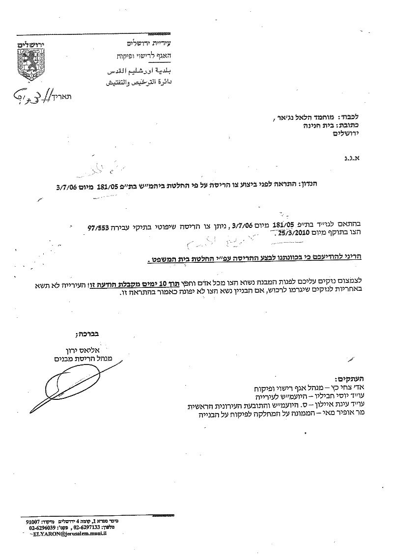
Photo 1: The demolition order given to Ar Rasheed Residential Tower families
Beit Hanina, Location & population
Beit Hanina; is a Palestinian community located approximately 5 kilometers to the north of Jerusalem city; The community has a mountainous topography with an elevation of 601-800 meters above the sea level. It is surrounded by Al-Ram & Dahiyat Al-Bareed from the north, Bir Nabala and Al Judera villages from the west, Al-Nabi Samuel and Beit Iksa villages from the south, Shu’fat and Shu’fat Refuge camp from the South and Hizma from the east. Beit Hanina’s total land area is 16284 Dunums, of which 2775 Dunums constitutes the built-up area, which is divided to two areas. Table 3 and Map 2 below:
|
Table 3: The built-up area of Beit Hanina village
|
|
|
Village Area Name
|
Built-up Area
(Dunum)
|
|
Beit Hanina Al-Balad (old village)
|
333
|
|
Beit Hanina Al-Jadida (new village)
|
2442
|
|
Total
|
2775
|
Source: The Geographical Information System, ARIJ
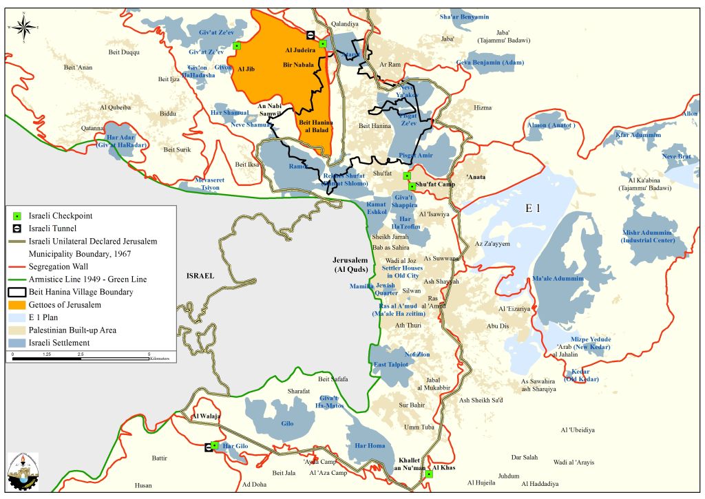
Map 2: The Beit Hanina Ghetto
The Israeli settlement program in Beit Hanina city
Following the 1967 occupation of the West Bank and the Gaza Strip, Israel invested in the occupied territory on a massive scale. Today, and because of this investment, more than 570.000 Israeli settlers live in the West Bank (of which, 238,000 Israeli settlers live in east Jerusalem). Beit Hanina city is a clear example of the Israeli settlement policy as it lost vast areas of its lands for the construction of six Israeli settlements, Atarot Industrial zone, Neve Yaakov settlement, Pisgat Ze’ev settlement, Pisgat ‘Amir settlement, Reches Shu’fat (Ramat Shlomo) settlement, and Ramot settlement. Table 4 gives details of the settlements established on lands of Beit Hanina city north of Jerusalem city.
|
Table 4: Israeli Settlements established on lands of Beit Hanina city
|
||||
|
Settlement
|
Settlement Area
(Dunum)
|
Area confiscated from Beit Hanina
(Dunum)
|
% of original settlement area
|
% of Beit Hanina city lands
|
|
Atarot
|
1377
|
513
|
37%
|
3.1%
|
|
Neve Yaacov
|
1241
|
525
|
42%
|
3.2%
|
|
Pisgat Zeev
|
1545
|
1152
|
75%
|
7.1%
|
|
Pisgat Amir
|
2515
|
879
|
35%
|
5.4%
|
|
Rekhes Shu’fat
|
1624
|
489
|
30%
|
3.0%
|
|
Ramot
|
3382
|
648
|
19%
|
4.0%
|
|
Total
|
11684
|
4206
|
|
25.82%
|
|
Source: the Geographical Information System � ARIJ 2010
|
||||
Previous Israeli Assaults on Beit Hanina city
On the 4th of January 2011, a house of a total area of 120 m², with two Storage floors, owned by Nayef Uwidawas demolished in Wad Ad Dam area in Beit Hanina city. The house was demolished under the pretext of unlicensed building. This assault is only one example of the uncountable Israeli assaults on lands and properties towards Palestinians living in Beit Hanina city and Jerusalemites living in occupied East Jerusalem; Chart I shows the number of demolished houses in Beit Hanina city in occupied East Jerusalem throughout the previous ten years. shows the number of demolished houses in Beit Hanina city in occupied East Jerusalem throughout the previous ten years.

Chart I: Number of Palestinian demolished houses in Beit Hanina city –
ARIJ Monthly Reports Database 2010/2011
A contradicting behavior from the Israeli Municipality of Jerusalem is the prohibition of issuing building permits for Palestinians living in East Jerusalem and suffocating their natural growth in a repressive way, while allowing settlers and Jewish organizations to expand on the expense of Palestinian lands. For example, in 2005, the Israeli Jerusalem Municipality disclosed the Jerusalem Town Planning Scheme of 2000 that will serve till the year 2020. According to the new master-plan, more than half of the eastern part of Jerusalem city is zoned as built-up areas and 24.4% are zoned as open â��green naturalâ�� areas. Of course the classification of land use varies according to the Israeli needs, as the Israeli Occupation Authorities intend to declare many of east Jerusalem areas as natural zones and public areas in order to confiscate the lands and change them into Jewish built-up area for Israeli settlers in the city. Perhaps the most obvious example is what happened to Abu Ghneim Mountain which was changed from a Nature Reserve ‘Green Mountain’ to a settlement, (Har Homa settlement) in 1997 and Reches Shu’fat (Ramat Shlomo) north of Jerusalem. Chart 2 shows the building rate for Palestinians and Israeli Settlers in occupied East Jerusalem.

Chart 2: the Building rate for Palestinians and Israeli Settlers in Occupied East Jerusalem
The Israeli Segregation Wall plan in Beit Hanina City
Under the pretext of ‘Security’, Israel commenced the construction of the Israeli Segregation wall in the occupied West Bank in June 2002. The construction of the wall affected many Palestinian communities in the oPt whether directly or indirectly as it grabbed valuable Palestinian agricultural lands and groundwater resources within its path. Beit Hanina is one, among tens of Palestinian communities in the oPt that was affected by the construction of the Israeli Segregation Wall as 3102 dunums (3.1 Km²) of its lands were annexed to Israel. The isolated lands include open spaces which are designated for future expansion and some agricultural lands that are considered as a source of living to many Palestinian families in the city, especially those who lost their jobs as construction workers in Israel.
Furthermore, a total of 1738 dunums of Beit Hanina’s city land from its western edge will be indirectly isolated as a cause of wall construction. This area is located between the route of the segregation wall and the Israeli settlements of Ramot and Rekhes Shu’fat; In addition, The construction of the wall deprives residents of Beit Hanina city from accessing considerable areas of lands. See Table 5.
|
Table 5: Lands Isolated from Beit Hanina city due to the construction of the Israeli Segregation Wall
|
||
|
Land Classification
|
Area (Dunums)
|
Lands Isolated from Beit Hanina city
|
|
Agricultural Lands
|
2897
|
1183
|
|
Open Spaces and Forests
|
5858
|
1744
|
|
Wall Zone
|
15
|
0
|
|
Palestinian Built-up Area
|
2772
|
417
|
|
Israeli Settlement
|
4555
|
15
|
|
Israeli Military Base
|
187
|
0
|
|
Total
|
16284
|
3359
|
|
In accessible portion of land upon wall completion
|
0
|
1738
|
|
Total
|
16284
|
5097
|
Source: ARIJ GIS Database 2010
To conclude,
The Israeli Policies and procedures are tremendously violating International Law and Human Rights Conventions such as:
-
Fourth Geneva Convention, Article 49 (12 August 1949): ‘The Occupying Power shall not deport or transfer parts of its own civilian population into the territory it occupies.’
-
Fourth Geneva Convention, Article 53 (12 August 1949): ‘Any destruction by the Occupying Power of real or personal property belonging individually or collectively to private persons, or to the State…is prohibited, except where such destruction is rendered absolutely necessary by military operations.’
-
Universal Declaration of Human Rights, Article 17 (10 December 1948): ‘No one shall be arbitrarily deprived of his property.’
-
UN Security Council Resolution 242 (22 November 1967): ‘The UN Security Council emphasizes ‘the inadmissibility of the acquisition of territory by war;’ calls for Israeli withdrawal from all occupied territories.’
- [1] Palestinians living in East Jerusalem must pay fees to the Israeli Municipality of Jerusalem when violating building rules in the city.
- [2] Lands of Beit Hanina (Al-Balad) village threatened by the Israeli Segregation Wall
[3] The Israeli Municipality in the Occupied city of Jerusalem Demolishes Nine Structures
[4] Demolishing Palestinian Houses
::::::::::::::::
Prepared by:
The Applied Research Institute – Jerusalem