The Israeli government has widened its long-term policy of forced displacement of the Palestinian population throughout the Occupied Palestinian Territory, mainly by targeting their houses and properties under Illegal pretexts.
On June 21, 2010, the Israeli Occupation Forces handed over local Palestinian residents of Al Hadidieyh and Khirbet Humsa east of Tubas city, in the northern parts of the Jordan Valley, demolition orders for their residential tin shacks under the pretext of lacking proper building authorizations from the “Israeli Civil Administration”. Table 1
|
Table 1: The Threatened structures in Al- Hadidieyh & Khirbet Humsa
|
|||
|
No.
|
Owner
|
Location
|
Structure Description
|
|
1
|
Abdel- Rahim Hussein Bisharat
|
Al- Hadidieyh
|
Residential Barracks
|
|
2
|
Mohammad ‘Ali Bani ‘Odeh
|
Al- Hadidieyh
|
Residential Barracks
|
|
3
|
‘Abdel-Mahdi Riyyad Salamin
|
Al- Hadidieyh
|
Residential Barracks
|
|
4
|
Harb Suleiman Abu Al-Qbash
|
Khirbet Humsa
|
Residential Barracks
|
|
5
|
Isma’il Freikh Abu Al-Qbash
|
Khirbet Humsa
|
Residential Barracks
|
|
6
|
Ibrahim Issa Abu-Al-Qbash
|
Khirbet Humsa
|
Residential Barracks
|
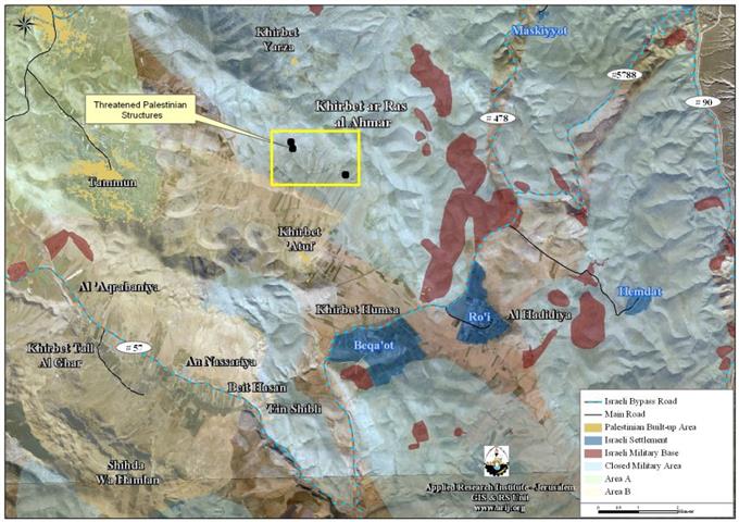
Al- Hadidieyh & Khirbet Humsa
Khirbet Humsa and Al-Hadidieyh communities are located in Al Buqui’a plain east of Tubas Governorate, in the northern parts of the Jordan Valley. The areas where the two Palestinian communities are located were declared ‘closed military areas’ right after the Israeli Occupation of the Palestinian Territory in 1967. Since that time, the Israeli occupation Army adopted an organized systematic policy to restrict access to the entire Jordan valley area, by which, the Israeli Army could control the development of land and the built-up areas there.
Today, Al-Hadidieyh community has a population of around 230 residents (PCBS 2010) and is located about 33 kilometers east of Tubas city. It is bordered by Pellas Illegal Israeli settlement from the north, Al-Jiftlik village from the south, the Illegal Israeli settlements of Beqa’ot and Ro’i from the west and Hemdat Illegal settlement from the east as well as the Israeli bypass road# 90. See map 1:

Map 1: Khirbet Humsa & Al-Hadidieyh Communities in Tubas
During the year 2009, Al-Hadidieyh community was targeted with 17 demolition and evacuation orders, where it is entirely threatened with eviction and displacement as all of Al-Hadidieyh families had received such military orders from the Israeli Occupation Forces.
The residents of the nearby community of Kirbet Humsa (populated by about 100 residents), have been subjected to similar circumstances where they have received more than 20 demolition and evacuation orders in the year 2009 from the Israeli Occupation Forces under the pretext of lacking building permits.
It is worth mentioning that Khirbet Humsa and Al-Hadidieyh communities are both surrounded by the Illegal Israeli settlements of Beqa’ot, Ro’i and Hemdat, in addition to many Israeli military bases, which adds to the Palestinian residents anguish and misfortune, because of the Israeli Army and the settlers’ daily and regular harassments. See Table 2
|
Table 2: The Illegal Israeli Settlements located in the vicinity of Al Hadidieyh & Khirbet Humsa In Tubas Governorate
|
||||
|
Colony Name
|
Location
|
Date Establishment
|
Population
|
Area-Dunums
|
|
Mehola
|
Tubas
|
1968
|
362
|
1759
|
|
Beqa’ot
|
Tubas
|
1972
|
156
|
2284
|
|
Ro’i
|
Tubas
|
1976
|
117
|
1573
|
|
Shadmot Mehola
|
Tubas
|
1978
|
516
|
1291
|
|
Hemdat
|
Tubas
|
1980
|
140
|
317
|
|
Rotem (Nahal)
|
Tubas
|
1984
|
18
|
51
|
|
Masskeyyott
|
Tubas
|
1987
|
NA
|
47
|
|
TOTAL
|
*****
|
*****
|
1309
|
7322
|
|
Source : ARIJ Database 2010
|
||||
Six Demolition Orders in Jinsafut east of Qalqilya
On June 22, 2010, the Israeli Occupation Forces handed over six local residents from Jinsafut village military orders notifying them that their houses will be demolished under the pretext of lacking building permits. Table 3
|
Table3: Details of the threatened houses in Jinsafut village east of Qalqilya
|
||
|
No.
|
Owner
|
Description of the threatened Structure
|
|
1
|
Yahiya Nabhan
|
House
|
|
2
|
Abdel Fattah Rashid Bashir
|
Under construction house
|
|
3
|
Hammad Saleh ‘Id
|
Under construction house
|
|
4
|
Basil ‘Ayed Sabra
|
Timber Warehouse
|
|
5
|
Mohammad ‘Ayed Sabra
|
Barracks
|
|
6
|
‘Atiyya Rayyan
|
Stone Factory
|
|
Source: Jinsafut Village Council
|
||
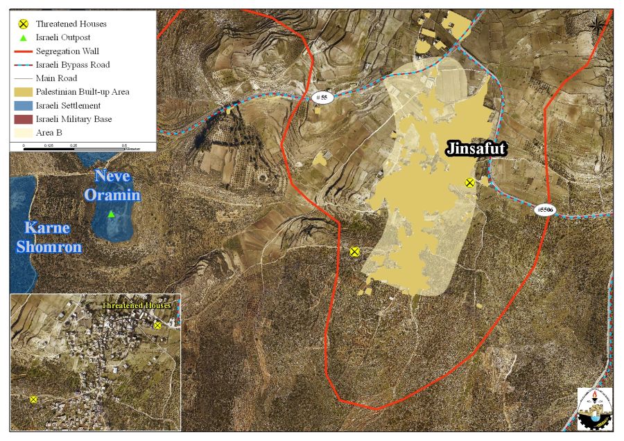
Map 2: the location of the threatened houses in Jinsafut village in Qalqilya
Jinsafut……… Location & Population
Jinsafut is a small village located east of the city of Qalqilya and 13.3 km from the Green Line (Armistice Line of 1949). The 2901 residents (PCBS 2010) of Jinsafut village live on 239 dunums (2.6% only from the total village lands -9335 dunums) which constitutes the Palestinian built-up area of Jinsafut village. The majority of Jinsafut residents work in agriculture, which constitutes the main source of income in the village.
Today, the built-up area of Jinsafut is entrapped by the Israeli segregation Wall that rounds the Israeli Kidumim settlements cluster from three sides; east, west and south. The northern part of the village is restricted by an Israeli controlled bypass road and parts of the segregation wall that runs along the village eastern side.
The Israeli Apartheid Segregation Wall from its east, west, surrounds Jinsafut village and south; in addition to the Illegal Israeli settlements of Immanuel, Neve Oranim and Karni Shomron, which had been built on 749 dunums (8% of the village lands (9335 dunums). See table 4
|
Table 4 : The Illegal Israeli Settlements built on Jinsafut village Lands
|
|||
|
Colony Name
|
Area- Dunums
|
Date Est.
|
Population
|
|
Neve Oranim
|
485
|
1991
|
NA
|
|
Immanuel
|
22
|
1981
|
3199
|
|
Karni Shomron
|
242
|
1978
|
6733
|
|
Total
|
749
|
*****
|
9932
|
|
Source : The Geographical Information System (GIS Unit)- ARIJ 2010
|
|||
Classification of Jinsafut Village Lands
According to the Oslo II Interim agreement of 1995, which was signed between the Palestinian Liberation Organization (PLO) and Israel, Jinsafut village was classified into areas A, B and C. In Area A, the Palestinian National Authority has complete autonomy over administrative and security issues, where in area B, the Palestinians have civil responsibilities and the Israeli Army continues to have security control, while in Area C, Israel has full control over the security and administrative issues. Table 5 clarifies the classification of Jinsafut lands according to Oslo Interim Agreement of 1995:-
| Table 5: Classification of Jinsafut Lands According to Oslo II Interim Agreement of 1995 | ||
| %from the total Town lands | Area-Dunums | Land Classification |
| 0 | 0 | Area A |
| 4 | 377 | Area B |
| 96 | 8,958 | Area C |
| 100 | 9,335 | Total |
| Source: The Geographical Information System (GIS Unit)- ARIJ 2010 | ||
Jinsafut & the Apartheid Wall
Jinsafut is one of the Palestinian villages that was severely affected by the Israeli occupation and now a 3.1 km long Segregation Wall, which stands to isolate some 86% (7985 dunums) of its lands. The lands that the village of Jinsafut lost and will lose once the segregation wall is completed will deprive the village and the Palestinians from stretches of the most fertile agriculture lands of Jinsafut village and the occupied Palestinian territory. Accordingly, the owners of these lands will not be able to reach and cultivate their lands unless they hold a special permits issued from the “Israeli Civil Administration” were the local resident and farmers have a hard time obtaining permits due to the numerous Israeli complex of requests.
To Conclude
On the ground, Israel is steadily moving toward forcibly displacing the Palestinian population all over the Occupied Territory mainly by demolishing their houses and properties under false Illegal pretext disregarding the international law and human rights conventions in this regard.
Under the International Law Rules and Conventions, Israel, as an occupying power, and is prohibited from destroying or seizing the Palestinian lands and properties, unless such acts are justified by security needs and as long as they are carried out on temporary bases.
-
Article 53 of the Convention provides that: Any destruction by the Occupying Power of real or personal property belonging individually or collectively to private persons, or to the State, or to other public authorities, or to social or cooperative organizations, is prohibited, except where such destruction is rendered absolutely necessary by military operations.
-
Article 147 of the same Convention indicated that: Extensive destruction and appropriation of property not justified by military necessity and carried out unlawfully and wantonly, is a grave breach of the Convention.
-
Art. 23 of the Hague Convention of 1907 also provide: In addition to the prohibitions provided by special Conventions, it is especially forbidden to destroy or seize the enemy’s property, unless such destruction or seizure be imperatively demanded by the necessities of war;
-
Also Article XXXI, Oslo II, 1995 provides: Neither side shall take any step that will change the status of the West Bank and the Gaza Strip.
:::::::::::::____
* projection
Prepared by
The Applied Research Institute – Jerusalem


