On May 14, 2010, the Israeli Occupation Forces handed over 12 local residents from Al Mughayer village east of Ramallah city military orders notifying them that their 11 houses and one stone factory will be demolished under the pretext of lacking building permits. Table 1 below gives details of the threatened structures in the village.
|
Table 1: The Threatened Structures in Al Mughayer village in Ramallah
|
|||
|
Familymembers
|
Type ofStructure
|
Owner’sName
|
No.
|
|
20
|
Under construction house | Wajeeh Naser Abu ‘Oleiyya. |
1
|
|
8
|
Under construction house | Mahmoud Abu ‘Oleiyya. |
2
|
|
**
|
Tow-story building | Mousa Abu ‘Oleiyya |
3
|
|
**
|
Under construction house | Hussein Jabir |
4
|
|
**
|
Under construction house | Mohammad Hamed |
5
|
|
**
|
Under construction house | Zayed Mahmoud |
6
|
|
**
|
Under construction house | Ahmad Mahmoud |
7
|
|
**
|
Under construction house | Ahmad Mahmoud |
8
|
|
**
|
Under construction house | Monir Mohammad Abu ‘Oleiyya |
9
|
|
**
|
Under construction house | Monir Mohammad Abu ‘Oleiyya |
10
|
|
**
|
Under construction house | Monir Mohammad Abu ‘Oleiyya |
11
|
|
**
|
Stone factory | Hussein Mahmud |
12
|
|
Source: AlMughayer village Council– Ramallah
|
|||
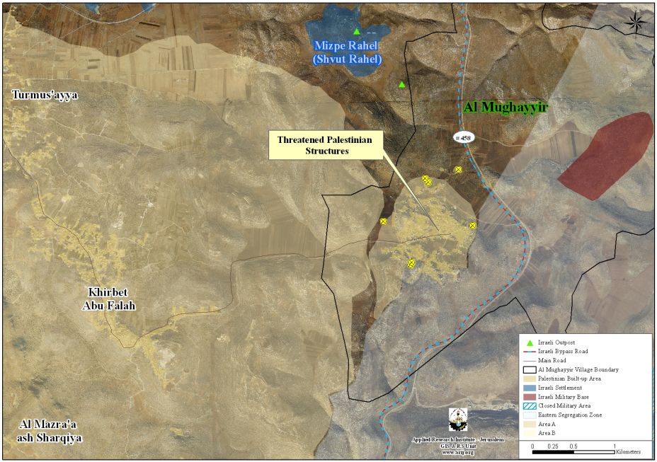
Map 1: Location of the notified structures in Al Mughayer Village
Al Mughayer Village……. Location & Population
Al Mughayer is one of the villages of Ramallah Governorate, located 22 km north of the city of Ramallah. The town is populated by 2704 residents (PCBS 2007). Al Mughayer is bordered by Duma village and the illegal Israeli settlement of Shevut Rachel from the north, Kafr Malek village from the south, the Israeli bypass road # 458 from the east, and Al Mazra’a Al-Sharqeyya from its west.
According to the Oslo II Interim agreement of 1995, Al Mughayer village lands, as well as the rest of the Palestinian Territory were divided into areas A, B and C. In Area A, the Palestinian National Authority has complete autonomy over administrative and security issues, where in area B, the Palestinians have civil responsibilities; while in Area C, Israel has full control over the security and administrative issues.
Consequently 94% from the total area of Al Mughayer village lands are classified as area “C “, where the residents live in this area, and when they want to build on their own lands, they are obligated to submit a request to the so-called “Israeli Civil Administration” which is related to the Israeli Occupation Army where their request most often denied. See the table 2 and the map below:
| Table 2: Classification of Al Mughayer’s Land According to Oslo II Interim Agreement of 1995 | ||
| %from the total Town lands | Area-Dunums | Land Classification |
| 0 | 0 | Area A |
| 6 | 2,061 | Area B |
| 94 | 31,875 | Area C |
| 100 | 33,936 | Total |
| Source: Geographical Information System- ARIJ 2010 | ||
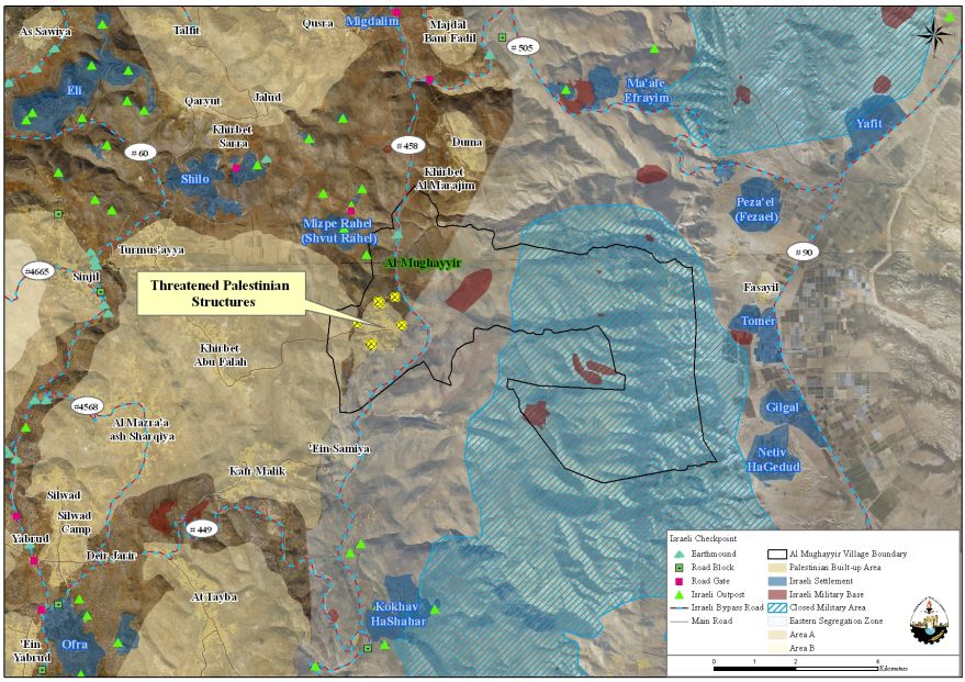
Map 2: The geopolitical Status of Al Mughayer Village
Voluntary Deportation
The residents of Al Mughayer village have a long history with the Israeli colonial practices, where 27,556 dunums (81 %) from the total area of the village are located within the Eastern Segregation Zone which had been declared by the Israel as a closed military area following the 1967 war, when Israel occupied the West Bank territory including east Jerusalem and the Gaza Strip..
Moreover, the Palestinian build up area of Al Mughayer village constitutes only 1.2% (437 dunums) from the total village area (33,935 dunums), which dramatically affects the life of the local residents of the village, where they actually deprived from their right to build and expand on their own lands.
Furthermore, Al Mughayer village was targeted many times by the herds of Israeli setters of the adjacent Illegal Israeli settlement of Shevut Rachel, where in the year 2009, the settlers attacked the lands of Al Mughayer village residents and uprooted more than 200 Olive trees. See table 3 below:
|
Table 3:Land use Land Cover for Al Mughayer villages’ lands
|
|
|
Land Classification
|
Area- Dunums
|
|
Agricultural Lands
|
4,532
|
|
Forests and Open Spaces
|
28,220
|
|
Israeli Military Base
|
746
|
|
Palestinian Built-up area
|
437
|
|
Total
|
33,935
|
|
Source: Geographical Information System Unit – ARIJ 2010
|
|
To Conclude
Local residents of Al Mughayer village are living under intolerable conditions, where they are under the hummer of the Israeli Occupation Army and the illegal Israeli settlers’ anvil practices which come on the expense of locals’ houses, lands, trees and properties. These practices mainly aim to the voluntary deportation of local residents of Al Mughayer village despite the fact that the Israeli targeting of the Palestinian population in the Occupied Palestinian Territory which is carried out either at the hands of Israeli Army or Israeli settlers are Illegal and unjustified and more than that they constitute a grave and fatal breach of all International law rules and conventions such as:
-
Article 53 & 147 of the Fourth Geneva Convention indicated that: Extensive destruction and appropriation of property not justified by military necessity and carried out unlawfully and wantonly, is a grave breach of the Convention.
-
Moreover Art. 23 of the Hague Convention of 1907 also provides: In addition to the prohibitions provided by special Conventions, it is especially forbidden to destroy or seize the enemy’s property, unless such destruction or seizure be imperatively demanded by the necessities of war;
-
Furthermore and under the Universal Declaration of Human Rights adopted and proclaimed by General Assembly resolution 217 A (III) of, December 10, 1948, Article 17 reads: ‘No one shall be arbitrarily deprived of his property.’ Which means it bans Israel from destroying or confiscating the property of the Palestinians at any case.
Prepared by: