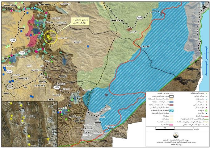
On the 9th of May 2001, the Israeli Occupation Authorities handed residents of Bani Na’im town military orders to halt the construction of their structures allegedly for being built without license due to their location in areas classied as ‘C’ which fall under the full Israeli control according to Oslo II Interim agreement of 1995. The orders targeted ten Palestinian families in the town which are owned by: Haroun Al Tarayra, Suleiman Muhammad Al Tarayra, Muhammad Suliemna Al Tarayra, Hasan Muhammad Al Tarayra, ‘Abdel Salam Al Tarayra, Daoud ‘Awad Al Tarayra, Suleimna Al Dumai, Qaher Fawzi Harahsha, Samer Fawzi Harahsha and Ibrahim Muwas. See Table 1
| Table 1: Targeted Palestinian Houses in Bani Na’im town in Hebron Governorate. | ||
| Area of threatened Structure | Owner’s Name | No. |
| 320 square meters | Suleimna Al Dumai | 1 |
| 360 square meters | Muhammad Suliemna Al Tarayra | 2 |
| 360 square meters | Haroun Al Tarayra | 3 |
| 220 square meters | Samer Fawzi Harahsha | 4 |
| 700 square meters | Abdel Salam Al Tarayra | 5 |
| 500 square meters | Ibrahim Muwas | 6 |
| 500 square meters | Daoud ‘Awad Al Tarayra | 7 |
| 240 square meters | Qaher Fawzi Harahsha | 8 |
| 600 square meters | Suleiman Muhammad Al Tarayra | 9 |
| 300 square meters | Hasan Muhammad Al Tarayra | 10 |
| Source: Bani Na’im Municipality, Hebron 2010 | ||
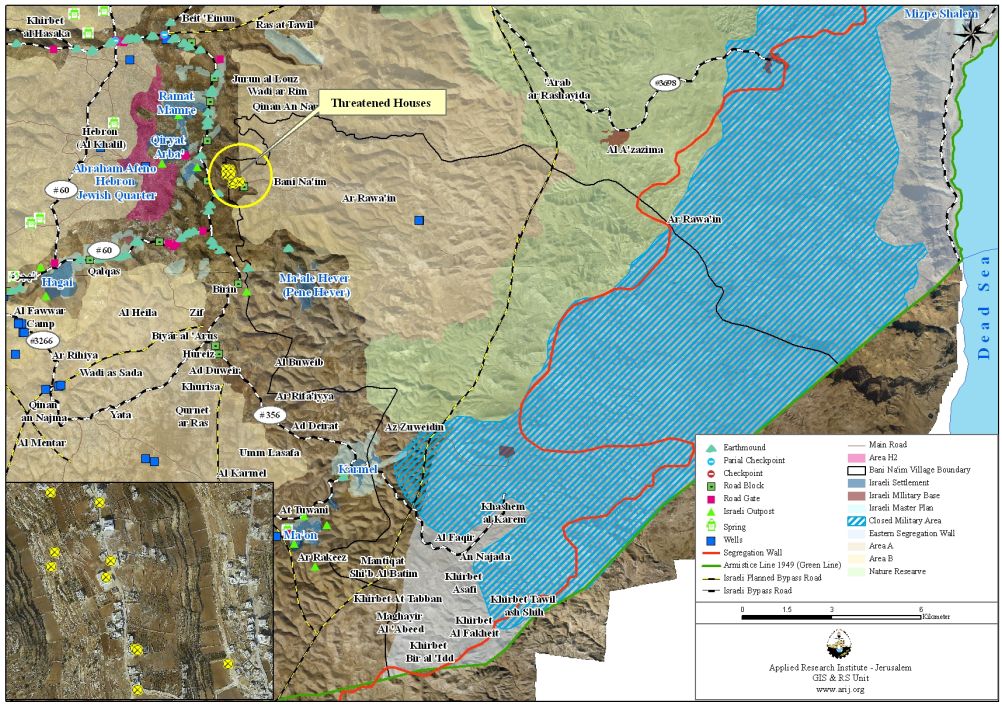
Map 1: Location of the targeted houses in Bani Na’im Town
The Israeli Civil Administration gave Palestinians of Bani Na’im town until the third of June 2010 to file their objections against the halt of construction orders and to proceed with license procedures. However, the orders also pointed out that pursuing license procedures does not guarantee Palestinians a license by the Israeli civil administration neither stop the possible demolition of the house during that time.
The Israeli allegations come on the basis that the notified Palestinian houses in Bani Na’im town have been built without obtaining the necessary building permits form the Israeli Civil Administration which holds responsibility over building and construction issues in areas ‘C’. However, according to the Oslo agreements signed between Israel and the Palestinian Liberation Organization (PLO), Israeli forces redeployments were scheduled to take place so that by the end of year 1999, the Palestinians would gain control over 95% of the West Bank area; however, Israel did not comply with the signed agreements and proceeded to make delays on the transfer of powers and responsibilities relating to territory to the Palestinian National Authority (PNA), which led to only partial withdrawal from the Palestinian land. By March 2000, the areas under effective Palestinian control (area A) amounted to no more than 18.2 %; area B amounted to 21.8% of the total West Bank total area while the remaining area which constituted 60% of the total West Bank area remained under the full Israeli control and weren’t handed over to the Palestinians.
Israel is illegally targeting Palestinian homes in areas under their control, which, according to the signed agreements, were supposed to be delivered back to the Palestinians.
Location and Physical Characteristics
Bani Na’im town is located 7 kilometres to the east of Hebron City in the southern part of the West Bank. It is bordered by Ar Rawa’in areas (Masafer Bani Na’im) to the east, Sa’ir and Ash Shuyukh towns to the north, Hebron City to the west, and Yatta town to the south (See map 2).
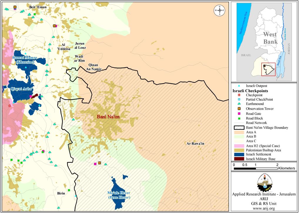
Map 2: Bani Na’im location and borders
Bani Na’im extends over a mountainous area east of Hebron Mountains at an elevation of 958 m above sea level. According to the Bani Na’im Municipality, Bani Na’im includes the following localities: Bani Na’im, Birin, Ar Rawa’in and Masaferet Bani Na’im. In addition, Masaferet Bani Na’im already includes ten other small localities: Mantiqat Al Ein, Mantiqat As Sahel, Mantiqat Qaber K’heil, Mantiqat Hilmi, Mantiqat Al Hamra, Mantiqat AL qurun, Mantiqat Al Mathbah, Mantiqat As Sweidat, Mantiqat Um Ar Raqam and Khor ‘Atara.
According to the Palestinian Central Bureau of Statistics (PCBS) census of 2007, Bani Na’im town is inhabited by 20,301 people, of whom 20,084 people live in Bani Na’im and 217 live in Masafer Bani Na’im. The population of Bani Na’im town constitutes about 3.67% of the total population of Hebron Governorate.
The Geopolitical Status of Bani Na’im Town
The Oslo II Interim Agreement signed in September 1995 between the Palestinian Liberation Organization (PLO) and Israel, concluded Israel’s withdrawal from areas of the West Bank, and that the Occupied Territory to be classified into Areas “A,” “B” and “C,” designating varying levels of control. This jagged distribution has scattered the Occupied Palestinian Territory and turned it into isolated cantons; physically separated from each other. Table 2
|
Table 2: The Geopolitical Divisions of Bani Na’im Town
|
||
|
Land Classification
|
Area in Dunums
|
Percent %
|
|
Area A
|
44715
|
21.3
|
|
Area B
|
5599
|
2.7
|
|
Area C
|
125456
|
59.6
|
|
Nature Reserve
|
34518
|
16.4
|
|
Total
|
210288
|
100
|
|
Area A
|
The Israeli army has pulled out fully and Palestinians hold all responsibilities for internal security and Public order.
|
|
|
Area B
|
Palestinians have full control over the civil administration and Israel continues to have overriding responsibility for security.
|
|
|
Area C
|
The Palestinians have responsibility for civil life such as economics, health, and education; while, Israel retains full control over security and administration related to the territory
|
|
|
Source: The Geographical Information System Unit – ARIJ 2010
|
||
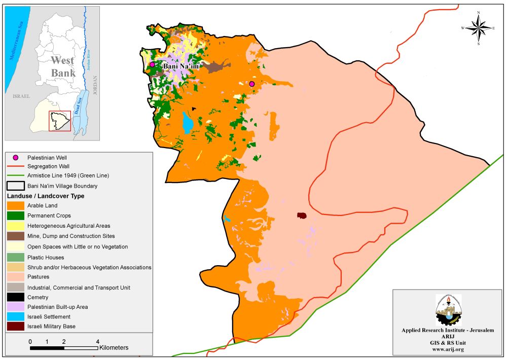
Bani Na’im town covers an area of 210,288 dunums of land, of which 65,935 dunums (31.4% of the total area of the town) constitutes the agricultural areas in the town, while a total area of 1052 dunums (0.5% of the total area of the town) constitutes the forest areas in the town. The open areas in the town amount to 136,658 dunums (65% of the total area of the town) while the urban area in the town occupies a total land area of 4316 dunums and it is the area where the urban construction is mostly concentrated.
Also the eastern part of Bani Na’im town lies within the West Bank’s eastern Segregation Zone. This sparsely populated eastern section covers a total area of 97701 dunums, (46.5% of the total town area). The reason for this small population is that the vast majority of the land was declared closed military area/ or nature reserve area by the Israeli Government since 1967. Accordingly, the Israeli Army prohibited any kind of development to that area, which utterly became in accessible to Palestinian farmers, grazers and landowners.
Settlements’ related activities in Bani Na’im Town
Israel’s activities in the Occupied Palestinian Territory are based on a systematic plan to construct and build more Israeli settlements as much as possible, in order to inflict facts on the ‘grounds’ with an intention to break Palestinian geographical contiguity to make the odds of a Palestinian State in the future practically unattainable. Israeli settlement activities in Bani Na’im town were exemplified in the construction of two Israeli settlements. These settlements are built on a total area of 682 dunums of lands and continue to expand until today:
1- In 1982, Israel laid the corner stone of Pene Hever settlement on Lands of Bani Na’im town. Today, the settlement occupies a total land area of 598 dunums and is inhabited by almost 400 Israeli settlers.
2- In 1981, Israel laid the corner stone for a second settlement on lands of Bani’ Na’im and Yatta towns. Today, the settlement occupies a total land area of 339 dunums of the two communities, of which, 84 dunums were confiscated from Bani Na’im town. The settlement is inhabited by 44000 Israeli settlers.
Bani Na’im Town and the Israeli Segregation Wall
The Segregation Wall has a serving purpose more than the Israeli claims to, the so-called “security” pretext. On the immediate level, it incorporates with the Israeli plan to segregate and take control of lands to be annexed to Israel once the Segregation Wall is officially declared as a political border, as implied by many Israeli officials. In Bani Na’im town, the Israeli Segregation wall will extend a length of 31.5 km on lands of Bani Na’im town, from its eastern part as shown in the map that was published by the Israeli Ministry of Defense website on April 30, 2007. Upon wall completion, up to 53,415 dunums (53.4 Km2) of open spaces and pastures will be isolated from Bani Na’im’s Town once wall constructions are completed in the area; in addition to 265 dunums (0.265 Km2) of agricultural areas. See Table 3:-
|
Table 3: Land use Land cover of Isolated lands in Bani Na’im Town
|
|
|
Land Classification
|
Area (dunum)
|
|
Agricultural Lands
|
265
|
|
Open Spaces and Pastures
|
53415
|
|
Total
|
53680
|
|
Source: The Geographical Information System Unit, ARIJ 2010
|
|
Map 3: The Israeli Segregation Wall plan in Bani Na’im Town
To Conclude,
Under the Fourth Geneva Convention, Israel, as an occupying power, is prohibited from destroying the Palestinian properties. However, it continues to violate Palestinians rights and breach international laws and treaties as the right to existence and housing. Article 49 of the Fourth Geneva Convention of 1949 clearly states that ‘The occupying power shall not deport or transfer parts of its own population into the territories it occupies’. Also Article 53 of the Fourth Geneva Convention clear that: ‘any destruction by the Occupying Power of real or personal property belonging individually or collectively to private persons, or to the State, or to other public authorities, or to social or cooperative organizations, is prohibited, except where such destruction is rendered absolutely necessary by military operations.’ The appropriation and destruction of Palestinian land is an especially serious violation of the Fourth Geneva Convention, Article 147 of which clearly prohibits, ”extensive destruction and appropriation of property, not justified by military necessity and carried out unlawfully and wantonly.’’))
Prepared by