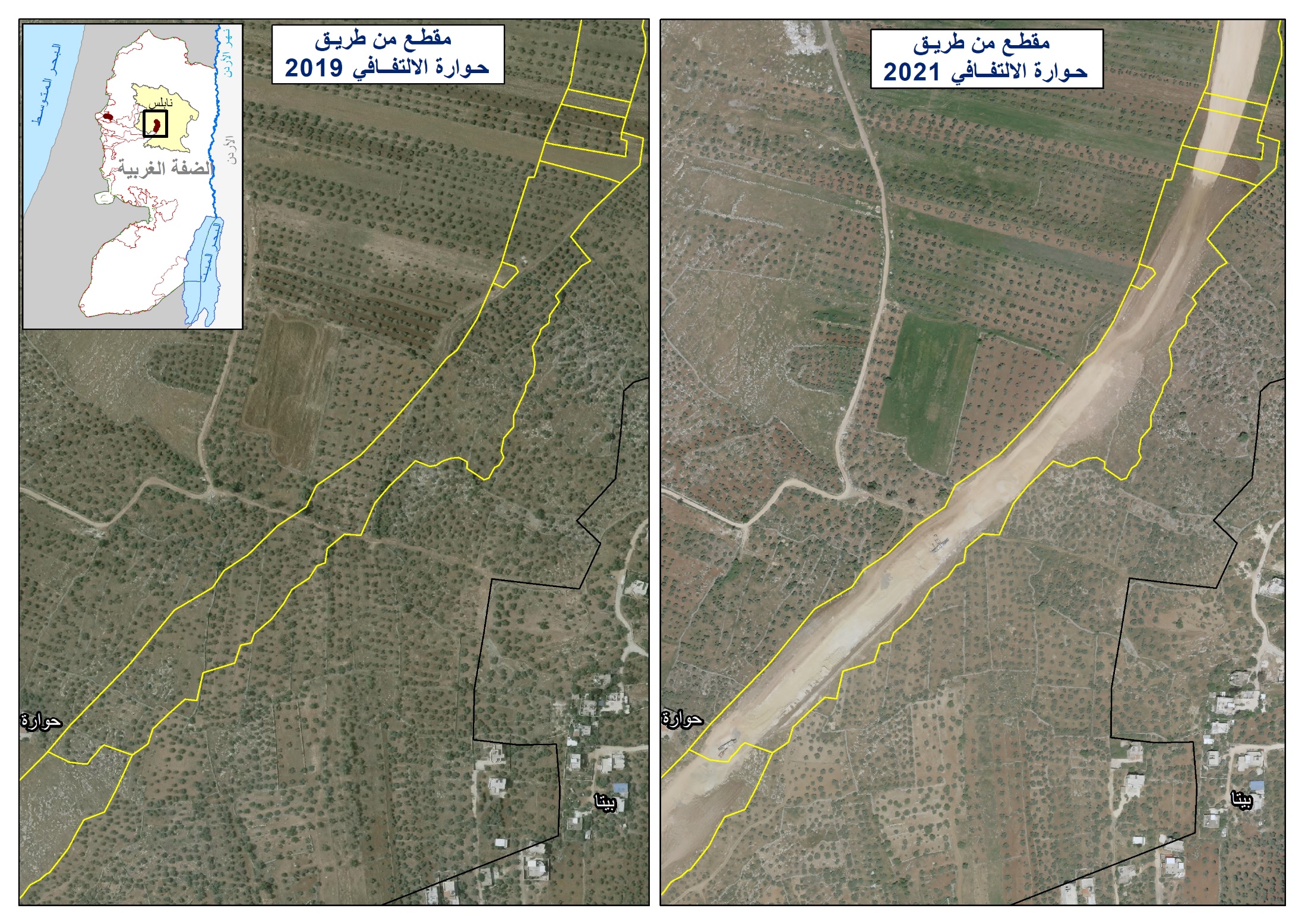
Violation: Stop the construction of an agricultural road.
Date: April 11th, 2010.
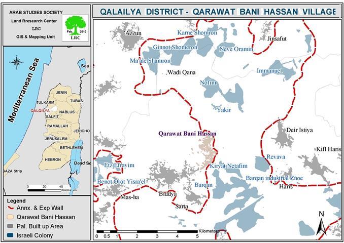
Location: The area of Ein Al Nuweitif, located east of the village of Qarawar Bani Hassan in Salfeet Governorate.
Affected: Around 40 Palestinian farmers in the village.
Details:
On the morning of Sunday April 11th, 2010, Israeli occupation forces stopped work on the establishment of an agricultural road leading to the spring of Ein Al Nuweitif which is located east of the village. The length of the aforementioned road is 1300 meters and is financed by the Palestinian Authority and is designed to benefit the farmers of the said location. The spring has been witnessing feverish attacks by the colonists from the illegal outpost of Havot Ya’ir which was established west of the town of Deir Istiya.
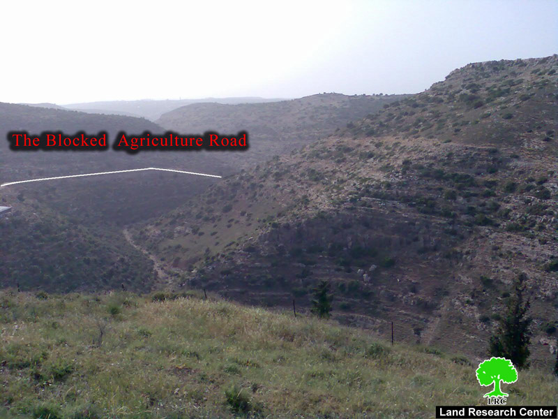
Photo 1: The targeted agricultural road – Qarawat Bani Hassan.
The usual pretext used by Israeli occupation forces to stop such work is that it is located within areas classified as Area C which needed an Israeli permission before it could be carried out. The Commander of Israeli forces in the area threatened to confiscate the heavy machinery and equipment if they would continue to work on the road. The Stop Work operation was carried out while Israeli colonists from the illegal outpost of Havot Ya’ir and the nearby colony of Nataviem are opening their own road leading to the spring in a feverish attempt to take control of it. It is worth noting that the spring is used by the farmers of Qarawat Bani Hassan for drinking and irrigation purposes.
Recently Israeli colonists have brought construction materials and bulldozers to establish a new colonial project in the village under the heavy protection of Israeli soldiers. A wave of physical attacks against Palestinian famers accompanied the attempt. Mr. Abdel Al Kareem Rayan, a farmer from the village, expressed the following for Land Research Center (LRC)’s field researcher: ‘ The village is suffering from the cancer of colonization and the frequent attacks by colonists throughout the years. For example, 6 Palestinian farmers were injured due to the attacks by colonists in less than a month. The village is surrounded by 4 colonies which besiege the village from the four directions. Attacks and colonial expansion take place despite the efforts done by the Municipality to stop them through contacting the Palestinian and Israeli Liaison Offices along with the Palestinian Authority and national forces.’
One of the victims of the attacks, Mr. Izzat Rizq Rayyan, indicated the following for LRC’s researcher: ‘ Israeli soldiers physically beat me while I was farming in my land near the spring. I requested the help of a number of rights organizations as to pressure occupation forces to stop such attacks. I am really afraid that the soldiers will come back again under pressure from the colonists especially that the current Israeli government is not interested in peace.’
Qarawat Bani Hassan: A Glance
The village is located on a hill 13 kilometers west of the city of Salfeet. The history of the village stretches back as far as 2,000 years ago. It’s been said that the name of the village (Qarawat) is the plural of (Qariya) meaning “villages”.
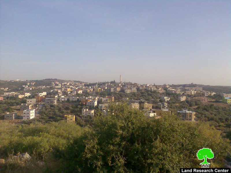
Photo 2: A general view of the village
The following Palestinian population centers surround the village; Bidya from the west, Sarta from the south in addition to Deir Istiya and Haris from the east. The population of the village is about 3840 while an additional 1,000 Palestinians from the village live outside of its current boundaries. There are three main clans in the village; A’asi, Rayyan and Mir’ei. The main source of income for the village is agriculture. The main crops are barely and olives while a good percentage of the villagers depend on the private sector for a living.
There are three springs in the village; Bar Abu Ammar, Al Majoor and Al Mahd. The drinking water is provided by the Israeli Water Company. A number of historical locations are present in the village including Dar Al Darb Al Frueids in addition to some Roman palaces. In addition, the village has a number of religious sites including Al Sheikh Ali, Amero Ibn Al A’as and Omar Ibn Al Khattab memorial sites. The village is surrounded by four Israeli colonies including Ma’ale Israel, Kiryat Natafiem, Rafafa and Yakir.
Prepared by
The Land Research Center
LRC