• About The Project
  • Palestine in Century
  • Selected Maps
  • Glossary
  • About ARIJ
  • About LRC
  • By Year
    • Case Studies By Year
    • Daily Report By Year
Friday, August 1, 2025
POICA
No Result
View All Result
  • Home
  • Settlements
    • New Israeli Settlements
    • Settlement Expansion
  • Israeli Violations
    • Agriculture
    • Confiscation
    • Demolition
    • Environment
    • Eviction of Palestinians
    • Settlers Attacks
  • Bypass Roads
  • Israeli Plans
  • Segregation
    • Checkpoints
    • Closure
    • Separation Plans
  • Military Orders
  • Reports
    • Daily Report
    • Monthly Report
    • Quarterly Report
No Result
View All Result
POICA
No Result
View All Result

A New Israeli Military Order to confiscate ten dunums of Beit Liqya lands southwest of Ramallah city

April 24, 2010
in Military Orders
A New Israeli Military Order to confiscate ten dunums of Beit Liqya lands southwest of Ramallah city
General Glance
Beit Liqya is one of the Palestinian towns of Ramallah Governorate, located about 13.4 km away from the city of Ramallah. The town is populated by 10,286 residents where it’s considered as the largest towns of Ramallah Governorate in terms of population (PCBS 2010).
 
Beit Liqya is bordered by Kharbatha Al- Misbah village from the north, the Segregation Wall from the south, as well as Beit- ‘Anan village from the southeast, At-Tira village from the east, and again by the Segregation Wall from its west.
 
According to the Oslo II Interim agreement of 1995, Beit Liqya town lands, as well as the rest of the Palestinian Territory were divided into areas A, B and C. In Area A, the Palestinian National Authority has complete autonomy over administrative and security issues, where in area B, the Palestinians have civil responsibilities; while in Area C, Israel has full control over the security and administrative issues. Table 1 clarifies the classification of lands of Beit Liqya:-
 
Table 1: Classification of Beit Liqya’s Land According to Oslo II Interim Agreement oF 1995
Land Classification
Area-km
% from the Town Area
Area A
0
0
Area  B
1,318
9.2
Area C
12,935
90.8
Total
14,253
100
Source: Geographical Information System – ARIJ, 2010
 
The Israeli Colonization Activities in Beit Liqya Town
Beit Liqya has been severely affected by the Israeli colonial plans, mainly by building the illegal Segregation Wall where the town lost more than 1500 dunums from its land for the construction of the Wall.
 
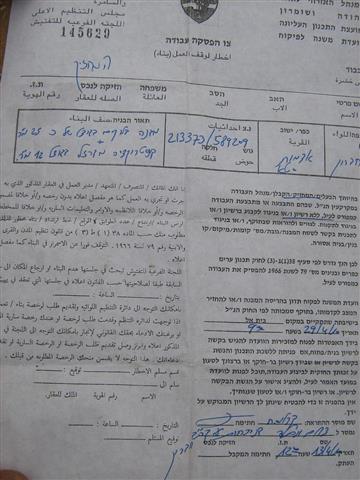
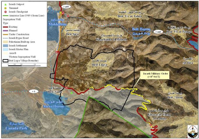
On March 10, 2010, the Israeli Army handed Beit Liqya municipality a new military order holding number (78/04/T) to confiscate an additional 10 dunums from lands of the town. This order came as an extension to a previously issued military order number 0765/2004, which was issued on March 26, 2004 to confiscate hundreds of dunums of Beit Liqya town lands to construct the Segregation Wall in the area which according to the Israeli maps, will stretch a length of 6 km long along the town’s land. See map 1 

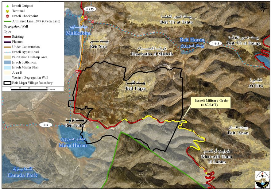
Map 1: The path of the Israeli Segregation Wall on Beit Liqya Lands
 
Mr. Hassan Mafarjeh, mayor of Beit Liqya town indicated that the municipality had filed a petition to the Israeli High Court of Justice in the year 2004, to enable owners of the isolated lands to access and cultivate their lands. The Court granted them the permission, but they have been surprised by the issuing of the new confiscation order, especially since the targeted 10 dunums will not be used to the construction of the Wall.
 
When the Segregation Wall is completed in Beit Liqya town, 3732 dunums (26% of the town’s total area) will be totally isolated west of the Wall. This means that local residents and owners of these lands will loose their right to reach their own lands without being issued a special permit from the so-called “Israeli Civil Administration” that is controlled by the Israeli Occupation Army.
 
Furthermore, the Palestinian built-up area of Beit Liqya town is only 703 dunums, which constitutes 4.9% from the town’s total land area (14,253 dunums). 1176 dunums of this area belongs to the master plan of the town, where the municipality of Beit Liqya has submitted many times to the Israeli Civil Administration for an expansion of the town’s master plan, but their request had been repeatedly rejected.
 
It is worth mentioning that the Segregation Wall in Ramallah Governorate extends along  78.7 km piercing through 23  Palestinians towns and towns isolating others, as in the case of Beit Nuba and some parts of Al-Judeira behind its path, while end up encompassing 14 illegal Israeli settlements and isolating 99069 dunums of Palestinian land behind its path.
 
To Conclude
Israel insists on violating nternational law, rules and conventions concerning the confiscation of Palestinian land and building the Apartheid Segregation Wall. 
  • Article 53 & 147 of the Fourth Geneva Convention indicates that: ‘any destruction by the Occupying power of real or personal property belonging individually or collectively to private persons, or to the State, or other public authorities or social or cooperative organizations is prohibited, except where such destruction is rendered absolutely necessary by military operations.’
  • Art. 23 of the Hague Convention of 1907 also provides: In addition to the prohibitions provided by special Conventions, it is especially forbidden to destroy or seize the enemy’s property, unless such destruction or seizure be imperatively demanded by the necessities of war;
  • Under the Universal Declaration of Human Rights adopted and proclaimed by General Assembly resolution 217 A (III) of December 10, 1948, Article 17 reads: ‘No one shall be arbitrarily deprived of his property.’ Meaning, this bans Israel from destroying or confiscating the property of the Palestinians in any case.


Prepared by:
  The Applied Research Institute – Jerusalem


Recommended For You

تهويد صامت بالأمتار: الطريق إلى بني كيديم خطوة نحو الشرعنة الاستيطانية

by arij
July 16, 2025
0
تهويد صامت بالأمتار: الطريق إلى بني كيديم خطوة نحو الشرعنة الاستيطانية

في الثامن عشر من شهر حزيران من العام 2025، تسلّم أهالي بلدتي سعير والشيوخ الواقعتين شمال شرق محافظة الخليل أمراً عسكرياً إسرائيلياً جديداً يقضي بمصادرة 4.8 دونما من...

Read moreDetails

من غير شرعية إلى واقع مفروض, البؤرة الاستيطانية سدي بوعز في رعاية الاحتلال

by arij
July 15, 2025
0

في الثامن من شهر تموز من العام 2025، سلّمت سلطات الاحتلال الإسرائيلي أمرًا عسكريًا جديدًا يقضي بمصادرة أراضٍ فلسطينية وممتلكات خاصة في بلدة الخضر جنوب غرب محافظة بيت...

Read moreDetails

ملاخي هشالوم: أكثر من مجرد بؤرة استيطانية … مشروع تهويد وتوسّع اسرائيلي

by arij
July 10, 2025
0
ملاخي هشالوم: أكثر من مجرد بؤرة استيطانية … مشروع تهويد وتوسّع اسرائيلي

قامت سلطات الاحتلال الإسرائيلي بتاريخ 7 تموز 2025 بنشر أمر عسكري جديد في الضفة الغربية المحتلة، يحمل عنوان: "أمر بشأن الأملاك الحكومية (يهودا والسامرة) (رقم 59) لسنة 1967"....

Read moreDetails

Israeli Order Targets Zububa Village Under Security Claims

by arij
June 24, 2025
0
أمر عسكري إسرائيلي يستهدف أراضي قرية زبوبا الفلسطينية لأغراض أمنية مستعجلة

As part of Israel's systematic violations against Palestinian land in the occupied West Bank", the Israeli occupation authorities, on June 14, 2025, issued a new military order to...

Read moreDetails

أمر عسكري إسرائيلي يستهدف أراضي قرية زبوبا الفلسطينية لأغراض أمنية مستعجلة

by arij
June 21, 2025
0
أمر عسكري إسرائيلي يستهدف أراضي قرية زبوبا الفلسطينية لأغراض أمنية مستعجلة

في خطوة جديدة تُضاف إلى سلسلة الانتهاكات الإسرائيلية بحق الأراضي الفلسطينية في الضفة الغربية المحتلة، سلمت سلطات الاحتلال الإسرائيلي بتاريخ الرابع عشر من حزيران 2025 أهالي قرية زبوبا...

Read moreDetails
Next Post
Israeli Occupation Forces threaten to erase Shu’ub Al Bottum off the map south of the city of Yatta

Israeli Occupation Forces threaten to erase Shu’ub Al Bottum off the map south of the city of Yatta

LATEST NEWS

في حضرة العنف, “المواطن الفلسطيني بين بندقية المستوطن وجرافة الاستيطان”

في حضرة العنف, “المواطن الفلسطيني بين بندقية المستوطن وجرافة الاستيطان”

by arij
July 30, 2025
0

........................................................

​الطرق الالتفافية الإسرائيلية: “مشنقة مشروع حل الدولتين”

​الطرق الالتفافية الإسرائيلية: “مشنقة مشروع حل الدولتين”

by arij
July 21, 2025
0

........................................................

تهويد صامت بالأمتار: الطريق إلى بني كيديم خطوة نحو الشرعنة الاستيطانية

تهويد صامت بالأمتار: الطريق إلى بني كيديم خطوة نحو الشرعنة الاستيطانية

by arij
July 16, 2025
0

........................................................

من غير شرعية إلى واقع مفروض, البؤرة الاستيطانية سدي بوعز في رعاية الاحتلال

by arij
July 15, 2025
0

........................................................

flag_yellow_lowEU-PfP-Logo

This website has been produced with the assistance of the European Union. The contents of this publication are the sole responsibility of ARIJ & LRC and can in no way be taken to reflect the views of the European Union.

© 2025 Copyright ARIJ . All Rights reserved. .

No Result
View All Result
  • Home
  • Settlements
    • New Israeli Settlements
    • Settlement Expansion
  • Israeli Violations
    • Agriculture
    • Confiscation
    • Demolition
    • Environment
    • Eviction of Palestinians
    • Settlers Attacks
  • Bypass Roads
  • Israeli Plans
  • Segregation
    • Checkpoints
    • Closure
    • Separation Plans
  • Military Orders
  • Reports
    • Daily Report
    • Monthly Report
    • Quarterly Report

© 2025 Copyright ARIJ . All Rights reserved. .