The village of Umm Salamuna lies to the south of Bethlehem city, some 6.5 kilometers far from it; It is bordered by Jouret Ash Sham’a village form the north, the villages of Al Halqam and Al Manshiya from the east, the villages of Marah Rabah and Beit Fajjar from the south, and the settlements of Efrata, Migdal Oz and the Israeli Segregation Wall from the west.
The village stands on a total land area of 2178 dunums, where the urban area constitutes about 2.3% of its area. The village is a home to 1000 inhabitants (ARIJ 2009), most of who tended to work in Agriculture after loosing their jobs as construction workers inside Israel following the eruption of the second Intifada in September 2000.
Um Salamuna village under Oslo II Interim Agreement
The Oslo II Interim Agreement signed in September 1995 between the Palestinian Liberation Organization (PLO) and Israel, concluded Israel withdrawal from areas of the West Bank, and that the Occupied Territory be classified into Areas “A”, “B” and “C”, designating varying levels of control. This jagged distribution has scattered the Occupied Palestinian Territory and turned it into isolated cantons; physically separated from each other.
Areas Definition in Oslo II Interim Agreement of September 1995
-
Area A: The Israeli army has pulled out fully and Palestinians hold all administrative responsibilities including internal security and Public order.
-
Area B: Palestinians have full control over the civil administration and Israel continues to have overriding responsibility for security.
-
Area C: The Palestinians have responsibility for civil life such as economics, health, and education; while, Israel retains full control over security and administration related to the territory.
Accordingly, lands of Um Salamuna village were classified into Areas B and C, as appears in Table 1 below:-
|
Table 1: The Geopolitical Divisions of Umm Salamuna village
|
||
|
Area
|
Area in dunums
|
%
|
|
Area A
|
0
|
0
|
|
Area B
|
440
|
20.2
|
|
Area C
|
1738
|
79.8
|
|
Total
|
2178
|
100
|
Source: Applied Research Institute – 2010
Settlements’ Related activities in the Village of Umm Salamuna
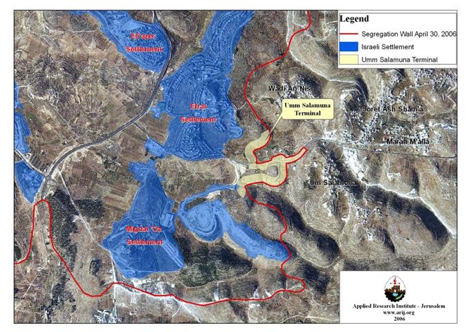
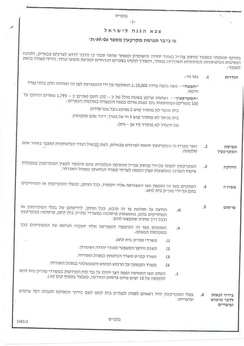
Umm Salamuna Planned Terminal
The Israeli Army issued on September 5, 2006, military order number (69/06/T) to confiscate 152 Dunums that belong to residents from Al-Khader and Beit Fajjar in Bethlehem and Beit Ummer in Hebron in order to construct this terminal located south of Bethlehem Governorate. The terminal comes in coincidence with the construction work of the Segregation Wall in that area. Map 1) to confiscate 152 Dunums that belong to residents from Al-Khader and Beit Fajjar in Bethlehem and Beit Ummer in Hebron in order to construct this terminal located south of Bethlehem Governorate. The terminal comes in coincidence with the construction work of the Segregation Wall in that area. Map 1
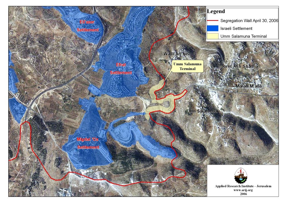
Map 1: Umm Salamuna planned Terminal
It is worth mentioning that Umm Salamuna terminal is the sixth terminal identified by the Israeli Army in Bethlehem Governorate and it is still in planning phase. Below is a description of each terminal that Israeli is planning or already built in the Governorate:
-
Gilo 300 Border Crossing at Bethlehem Northern Entrance – Status: Operational: Constructions of Rachel’s Terminal started early in the year 2004. the Israeli Army added several mobile caravans to the site; in addition to well-developed equipments, watchtowers, and security establishments, aiming at transforming the site into a huge terminal (crossing border), and totally separating Bethlehem Governorate from Jerusalem Governorate. On November 15, 2005, the Israeli authorities inaugurated terminal Gilo ‘300’ at the northern entrance of Bethlehem Governorate. See Gilo terminal diagram.
-
Mazmuria Trade terminal at Bethlehem eastern entrance – Status: Operational: In September 2005, the Israeli Army declared a plan to establish commercial terminal on confiscated land from Al-Khas and An-Nu’ man Villages located east of Bethlehem Governorate. The confiscation process was carried out in accordance to four Israeli military orders holding numbers (156-5-T), (154-5-T), (155-5-T) and (52-05); which were handed out to residents of the two villages informing them that 43 Dunums of their lands will be confiscated to construct a trade passage and an additional part sections of roads designated to serve the trade passage, leading to Har Homa settlement and consequently, to Israel.
-
Al Jab’a Trade passage – Status: in Planning phase: On August 22, 2005, the Israeli Occupation Army handed out residents of Al-Jab’a two military orders declaring the confiscation of 181 dunums for the construction of Al-Jab’a Terminal. According to the first military order (#T/158/ 05), 110 dunums of Al-Jab’a lands, and the nearby village of Surif were designated for confiscation to alter the existing checkpoint south of Al-Jab’a to a trade passage.
-
Al Khader Crossing Passage – Status: under construction: On November 21, 2005, the Israeli Army issued military order #210/05/T to confiscate 85 Dunums (according to the order) from three Palestinian communities west of Bethlehem Governorate (Beit Jala, Battier, and Al-Khader) to construct a tunnel and a terminal for travelers between Bethlehem western rural area and Bethlehem Governorate.
-
Al Walajeh Terminal – Status: in planning phase: On February 19, 2006, the Israeli Occupation Army issued a new military order (#25/06/T) to confiscate 39.8 dunums from Al-Walajeh village (parcel Block 3) and Beit Jala city (parcel Block 2). The order identified the reason for the confiscation to “military purposes,” which was later defined for the construction of a new Terminal in the area, (Har Gilo Terminal).
The Israeli bypass Road number 3157
The Israeli bypass road number 3157 stretches across 5.5 km in length in Bethlehem governorate. It extends from Efrat settlement road junction in the west and continues towards the east passing through the lands of Umm Salamuna, Marah Ma’alla, Jouret Al Sham’a, Marah Rabah, Al Manshiya and Al Halqam villages until it connects with the Israeli Bypass road number 356 in the west. Together, the two Bypass roads (# 3157 and # 356) form a geographical link between the illegal Israeli settlements cluster located southeast of Bethlehem governorate (Nikodim, Kfar Eldad (El David) and Teqou'(including Teqou’ C & D) with Jerusalem via Har Homa settlement, and with the Israeli settlements’ cluster of Gush Etzion in the west and settlements inside the Green Line (1949 Armistice Line).
The Israeli Segregation Wall plan
In June 2002, the Israeli Government launched its policy of unilateral segregation between Israel and the Occupied Palestinian Territory (OPT) by establishing a Segregation Zone along the western terrains of the occupied West Bank. The Israeli Segregation Zone covers substantial sizeable and significant land areas, rich with natural resources (water aquifers) as it runs along and through the western part of the West Bank from north to south, grabbing the most fertile agricultural lands, isolating Palestinian communities in enclaves, undermining the territorial contiguity between the Palestinian villages and cities, controlling the natural resources, and encapsulating most of the illegal Israeli settlements. At this time, an explanation of the term “Segregation Wall” should be made obvious as it reflects two shapes of structures used by the Israeli Army to complete their territorial separation mission in the occupied Palestinian territory, it is either concrete partition of 8-12 meters in height or in the other case, and multi line fences are used. In both cases, the term Segregation Wall applies.
According to the latest revised route of the Israeli Segregation wall route that was published on the Israeli Ministry of Defense website on April 30, 2007, showed that 1.7 km wall line will extend on lands of Umm Salamuna village and will cut 352 dunums (16.2%) of its lands west of the wall, within the Western Segregation Zone which Israel intends to annex to Israel once wall constructions are completed in the area. Not forgetting to mention that the zone that Israel is planning to annex includes 11 Israeli settlements along with seven other Palestinian communities with a total population exceeding 22500 Palestinian residents. Map 2
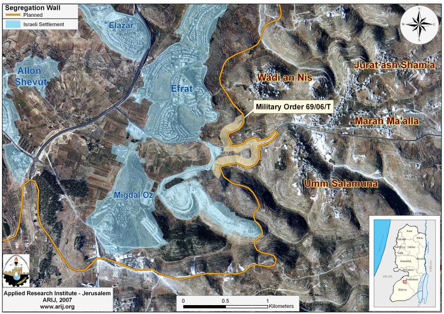
Map 2: The Israeli Segregation Wall Plan on lands of Umm Salamuna Vullage and its surroundings.
Works on constructing the wall on lands of Umm Salamuna village commenced in January 2007 when several Israeli bulldozers guarded by the Israeli Army started destroying farm lands planted with Grape vines and Olive trees for the construction of the wall. The destroyed lands are privately owned by Palestinian farmers from the village which also constitutes their only source of income.
Demolition of Palestinian houses in Umm Salamuna Village
On April 21, 2007, residents of Umm Salamuna village were delivered new Israeli military orders to demolish six Palestinian houses in the village under the pretext that the houses were built without proper building permits issued from the Israeli Civil Administration due to their location in Area ‘C’ which falls under the full Israeli control according to OSLO II interim agreement but was supposed to be handed out to Palestinians upon. Table 2 lists owners of the threatened houses.
|
Table 2: Threatened houses in Umm Salamuna Village
|
|
|
Owner’s Name
|
Military Order No.
|
|
Mohammad Mahmoud Hayyan
|
|
|
Mohammad Talab Taqatqa
|
|
|
Khaled ‘lyan
|
|
|
Akram Isma’eel Abu Rahma
|
|
|
Sami Ibrahim Taqatqa
|
|
|
NA
|
141212
|
Source: Um Salamuna Village Council – 2007
The International Legal Status of the Segregation Wall
The Israeli Segregation Wall violates virtually every existing humanitarian code, human rights and civilized laws; including the right to Self-Determination, the right to freedom of movement, the right to work, the right to medical treatment, the right to education, the right to an adequate standard of living and access to holy places, all of which emphasized in the ICJ 2004 ruling. The ICJ decision upholds the right to self-determination of the Palestinian people, which the Israelis deny them. The Israeli Segregation Wall disrupts the territorial integrity, unity, and contiguity. ‘Self-Defense’ or ‘state of necessity’ can not be used as justification for violating this right and other international legal principles and, therefore, Israel must cease construction and all other states must refrain from supporting Israel in building the Wall. Moreover, the construction of the segregation Wall is an explicit violation of all peace agreements signed between the Israelis and Palestinians, and a breach to the Oslo Interim Agreement of September 1995, which states:
-
The ICJ believes that the Wall is an attempt to connect settlements and settlers to Israel, creating ‘facts on the ground’ and de-facto annexing Palestinian land, which will have a significant impact on future negotiations regarding borders. Israel is also bound to the Hague Convention of 1907, which violates by confiscating land to construct the Wall on.
-
The Wall violates the Right to Self-Determination, the Law of Belligerent Occupation and Human Rights Law.
-
The wall results in the violation of human rights including the right to freedom of movement, access to holy places, to work, to health, to education, and to an adequate standard of living. The ICJ decision upholds the right to self-determination of the Palestinian people, which they are prevented from exercising by the wall’s disruption of the territorial integrity and unity of the population. ‘Self-defense’ or ‘state of necessity’ cannot be used, as justification for violating this right and other international legal principles and therefore Israel must cease construction.
-
The Court has reached the conclusion that the construction of the Wall by Israel in the Occupied Palestinian territory is contrary to international law and has stated the legal consequences that are to be drawn from that illegality. From the ICJ ruling in July 9, 2004.
“Neither side shall initiate or take any step that will change the status of the West Bank and the Gaza Strip pending the outcome of the permanent status negotiations” (Article XXXI, clause 7)
Prepared by:


