
The Governorate of Hebron is located in the southern part of the West Bank. It is the largest Governorate in the West Bank in terms of size and population. Its area is about 1068 km2, about 19% of the West Bank total area. The population of Hebron Governorate is 607,146 according to the estimates of the Palestinian Central Bureau of Statistics (2008). The number of Palestinian communities in the Governorate is 158, the largest of which is the city of Hebron. See table 1 for Hebron Governorate’s Land use/ Land cover.
|
Table 1: Hebron Governorate’s Land use/ Land cover |
||
|
Item |
Area in Km² |
Percentage of isolated area |
|
Agricultural Areas |
328 |
30.7% |
|
Palestinian Built-up Area |
84 |
7.9% |
|
Israeli Controlled Areas |
232 |
21.7% |
|
Forests |
14 |
1.3% |
|
Open spaces& others |
410 |
38.4% |
|
Total |
1068 Km2 |
100% |
|
ARIJ Database – 2008 |
||
Hebron Governorate under the Oslo Accord
The Oslo II Interim Agreement signed in September 1995 between the Palestinian Liberation Organization (PLO) and Israel, concluded Israel withdrawal from areas of the West Bank, and that the Occupied Territory be classified into Areas “A,” “B” and “C,” designating varying levels of control. This jagged distribution has scattered the Occupied Palestinian Territory and turned it into isolated cantons; physically separated from each other.
Under the signed agreement, Hebron Governorate was fragmented to areas (A=24%), (B=22%) and (C=48%), in addition to 6% as a nature reserve area, all of which as a part of withdrawal process to be completed before the end of 1999 prior to the instigation of negotiation over the final status issues.
Like the other Palestinian governorates, the bulk area of Hebron governorate is identified as area “C” where Palestinian has no control what so ever, and most importantly that Palestinian existence is virtually minimum in comparison to the density of the population in areas “A” and “B” which is much more densely populated respectively. See Table 2.
|
Table 2: Land Classification for Hebron Governorate according to Oslo Agreement of 1995 |
||||
|
Area Classification
|
Area/ Km2 |
% of Governorate’s Total Area |
% of Governorate’s Total Population per Classified Area |
Population Density per Area- Km2 |
|
Area A |
254 |
24 |
65% |
1562 |
|
Area B |
239 |
22 |
31% |
795 |
|
Area C |
513 |
48 |
3% |
37 |
|
Nature Reserves |
62 |
6 |
1% |
19 |
|
Total Area |
1068 |
|
|
|
|
ARIJ GIS Database – 2008 |
||||
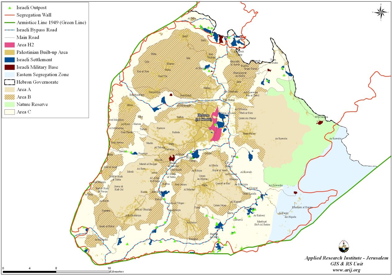
Map 1: Hebron Governorate
Hebron (H1&H2 Protocol)
In January 1997, Israel and the Palestinian Liberation Organization (PLO) signed the Hebron protocol, which divided the city of Hebron into 2 parts: H1 and H2. In the area identified H1, which covers approximately 20 % of the municipal boundary; there are around 130,000; it is an area where the Palestinian Authority has limited autonomy. H2 area falls completely under the control of the Israeli Army. It accommodates some 35,000 Palestinians and 600 illegal Israeli-Jewish settlers who are guarded by some 2000 Israeli soldiers.
H2 area is completely enclosed and heavily guarded with xx different kind of obstructions (checkpoints xx, roadblocks xx and military barriers xx cutting roads) all of which aim to control access points to the Old City of Hebron and the H1 area. Farmers from around the city has no access to the city's old markets, including the vegetable market, gold market, yogurt market, leather market and others which have been under closure since the beginning of the current Intifada in 2000. As of April 2006, more than 78 closures of different kinds block the H2 area, particularly the old city and Al-Suq area. Many of these blocks are on the roads leading to the old market (Al- Suq) area, Al Shohada street and on the 'prayers’ road' which was built for exclusive Jewish use from Qiryat Arba' to Ibrahimi mosque.
Restrictions on Palestinians’ movement were imposed on all roads that run near settlements. Students from Cordoba school in Al Shohada street cannot use the main road; even though it was rehabilitated by foreign donors provided that it is used by both Palestinians and Israelis, however, the Israelis force the Palestinian students to a detour around the southern side of the school across the fields so as not to cross path with settlers along Al Shohada street. Palestinians who live within the H2 area are required to register with the Israeli Army to access their homes. See Map 2
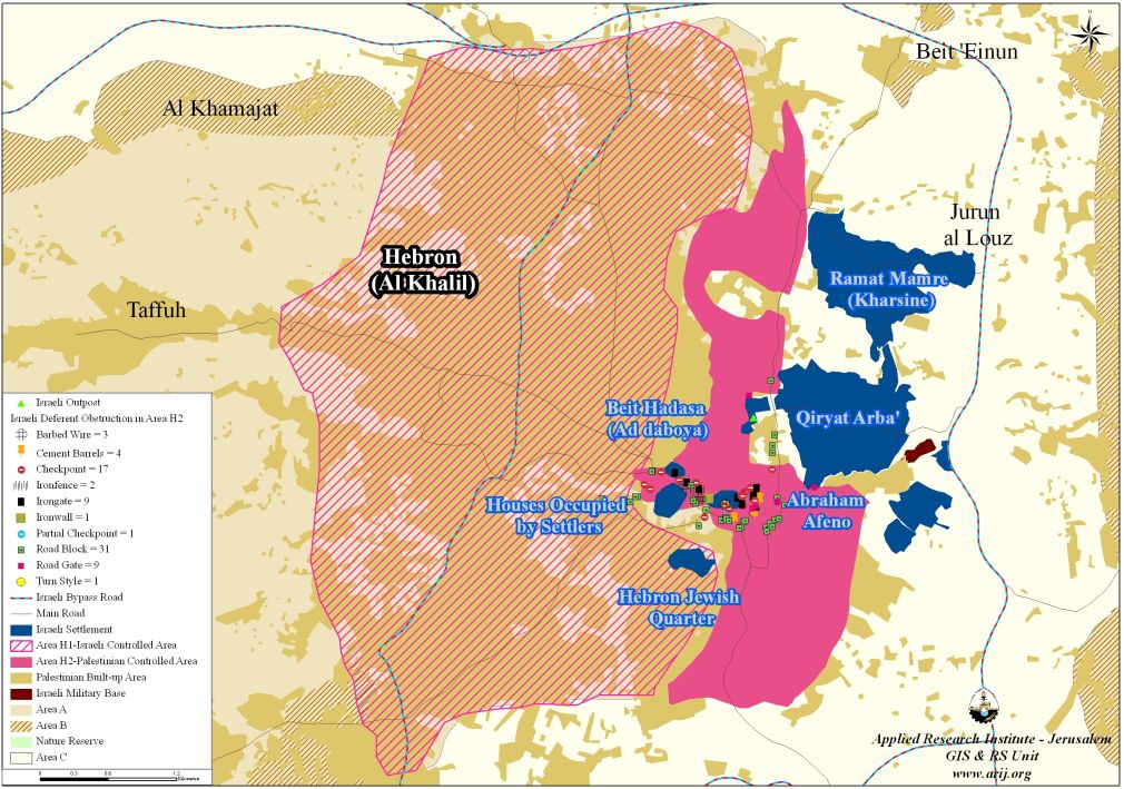
Map 2: H1 & H2 areas of Hebron City
Movement restriction in Hebron 2
H2 section of Hebron city is surrounded with checkpoints, roadblocks and military barriers cutting roads leading to other parts of the city in Hebron 1 and even to other parts of Hebron 2 such as the only industrial zone known as “Al Fahs” area. Farmers from around the city has no access to the city's old markets, including the vegetable market, gold market, yogurt market, leather market and others which have been under closure since the beginning of the current Intifada.
Restrictions on Palestinians’ movement were imposed on all roads that run near settlements. Students from Cordoba school in Al Shohada street cannot use the main road; even though it was rehabilitated by foreign donors provided that it is used by both Palestinians and Israelis, which the Israelis did not agree to and now they make the Palestinian students detour around the southern side of the school across the fields to avoid crossing the path of settlers along Al Shohada street.
Out of the aforementioned closures, there are 14 checkpoints preventing Palestinians from driving or walking inside Hebron 2. Palestinians who live within the H2 area are required to register with the Israeli army to reach their homes. For instance, in the area of Wadi Al Gruz, a Palestinian quarter between the settlements of Kiriyat Arba' and Givat Kharsina, earth mounds, roadblocks and gates has isolated the residents from the rest of the city.
Impact of Israeli Closure on commercial activities
The Israeli measures during the second Intifada (military orders, prolonged curfews) particularly during 2001 and 2002, next to Israeli settlers' violence have caused to cripple the Old market (Al-Suq) of trade. Shopkeepers resort to back- to- back system of transportation (moving goods from one vehicle to another) at the gates to bring in goods. The wholesale and vegetable markets were relocated from H2 to H1. According to the Palestinian Ministry of National Economy there were 1610 shops licensed in H2 before September 2000. Currently, more than 1000 shops are closed, one third of which by military orders. According to Hebron Rehabilitation Committee, of the 650 shops and storage places still located in the Old Suq, only 10% are still functioning to this time.
The aforementioned conditions have increased poverty in H2. According to a survey conducted by the Ministry of National Economy (2005), the average income per household in H2 area is about NIS 700 per month, which is well below the poverty line. The International Committee of the Red Cross initiated a monthly distribution of food packages in 2002 to almost 2500 households in H2 that includes all of the Old market (Al- Suq) residents.
Settlers' violence
Israeli settlers continue their daily violent attacks against residents and properties inside the old city and in Wadi An Nasarah quarter that set in close proximity to Kiriayt Arba' settlement. These continuous attacks aim to dismiss Palestinian families out of the area, particularly those living in the Old market (Al-Suq) and near the settlements. barbwires has been erected above the sections of the Old market (Al-Suq) running under Avraham Avino settlement and above the Old Shalala street running under Beit Hadasah (Daboyia) settlement from where settlers throw garbage, stones and empty bottles at the heads of pedestrians and store keepers in an act of continuous humiliation of human beings and to discourage movement below.
Humanitarian effects of closure and violence
On Religious Rights: prayers have to pass through a series of iron metal detector gates to enter the Ibrahimi mosque. This long process could take up to half an hour to reach the mosque. Prayers have to stand in lines in front of the gates and wait for permission from soldiers to enter into the gates for checking one by one. Some times, people are stuck inside the rolling gate waiting for the soldier to press a button to allow access.
This humiliating process only leads to an increase in the level of anger and tension amongst Palestinian prayers and residents of the area. In certain Jewish anniversaries and religious feasts, the Ibrahimi Mosque Mu'azin (one who calls for prayer) is prohibited from performing his task. Some times, this ban could last for many days and nights.
In the health sector, restrictions on movementimposed on various parts of H2 mean that medical evacuations are either delayed or denied. Ambulances cannot reach H2 or the eastern side of Hebron. The Palestine Red Crescent Society estimates that, as a direct result of the Israeli closures and restrictions on movement in the old city, it takes patients an additional 7 to 17 minutes to reach a hospital. Even, when coordination with the Israeli army is necessary (usually to pass through a checkpoint) the average it takes a patient 47 minutes to get to a hospital.
The unreliability of emergency medical care for H2 area has compelled sick people and pregnant women to leave their houses and move close in H1 area to be closer to hospitals, they either rent a closer house or live with relatives.
Fire trucks located in H1 area also faces delays when they are called to H2 area; as they are held on checkpoints for approximately 15 minutes (at least), until approval to let them inside H2 area comes through. Between September 2000 and January 2004, the fire brigades responded to 120 calls from H2, 38 calls of which, the fire trucks had to wait for more than one hour before reaching their destination.
On the Educational Level: school attendance and pupils' performance are dropping in schools close to settlements. For example, attendance in the three schools closest to settlements – Al Ibrahimiyye, Cordoba and Al Fayhaa schools- has dropped to almost 50 % since September 2000 because the children cannot study in unsafe conditions.
::::::::::::__
[1] Including 2 Israeli Army military bases
[2] Areas Definition in Oslo II Interim Agreement of September 1995
Area A: The Israeli army has pulled out fully and Palestinians hold all responsibilities for internal security and Public order.
Area B: Palestinians have full control over the civil administration and Israel continues to have overriding responsibility for security.
Area C: The Palestinians have responsibility for civil life such as economics, health, and education; while, Israel retains full control over security and administration related to the territory.
Prepared by:
The Applied Research Institute – Jerusalem


