• About The Project
  • Palestine in Century
  • Selected Maps
  • Glossary
  • About ARIJ
  • About LRC
  • By Year
    • Case Studies By Year
    • Daily Report By Year
Saturday, May 23, 2026
POICA
No Result
View All Result
  • Home
  • Settlements
    • New Israeli Settlements
    • Settlement Expansion
  • Israeli Violations
    • Agriculture
    • Confiscation
    • Demolition
    • Environment
    • Eviction of Palestinians
    • Settlers Attacks
  • Bypass Roads
  • Israeli Plans
  • Segregation
    • Checkpoints
    • Closure
    • Separation Plans
  • Military Orders
  • Reports
    • Daily Report
    • Monthly Report
    • Quarterly Report
No Result
View All Result
POICA
No Result
View All Result

Halt of construction orders in In Azzun town

October 6, 2009
in Military Orders
On 29 September, 2009, personnel from the planning and construction committee of the so-called Israeli civil administration in the West Bank handed over halt- of -construction orders to 7 citizens form Azzun town, Qalqiliya governorate against their houses and agricultural installations under the pretext of building in zone C of Oslo agreement’s classifications without having proper licensing from the Israeli side. Table 1, Notified owners by name, family members, No, of housing units, No. of agricultural installations and area.
No.
Owner’s name
#
Fam. Mem.
#
Children
#
Housing units
#
Agr. installation
Area
M2
Notes
1
Naser Salameh Salim
6
4
1
1
250
Inhabited Basement and 1st floor
2
‘Ikrima Yusif Salim
3
1
2
0
240
 Inhabited two floors
3
Azem Mohammed Salim
8
4
3
0
340
 Inhabited three floors
4
Rashid Abdullah Hussein
4
2
2
0
240
Under construction two floors
 
5
Musa Sulieman Abu Labada
10
5
1
0
130
Uninhabited one floor
6
Sai’d Suker Salim
0
0
0
1
60
Poultry farm
7
Kamal Yusif Salim
7
4
1
0
100
Under construction one floor
Total
38
20
10
2
1360
 
Source: LRC field work   


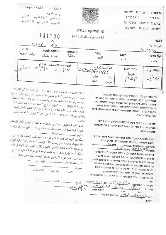
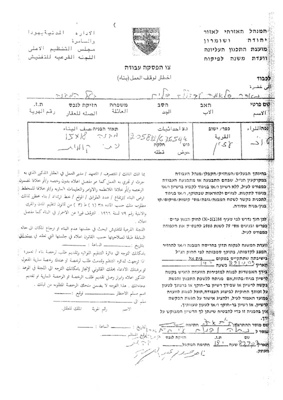
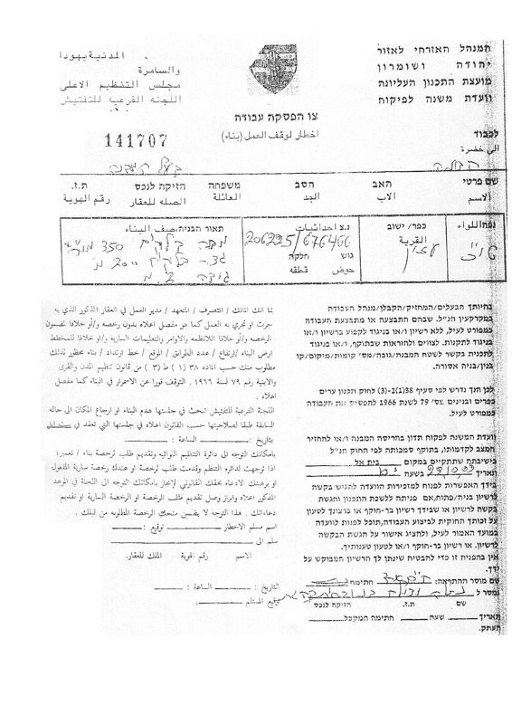
The notified premises are located in the vicinity of the towns’ master plan and in some cases the notified houses are only 12 meter away from the village borders. On the other hand, some of the notified premises were built more than ten years ago such as the house of Mr. ‘Ikrima Yusif Salama, 43 years old, whose house was built in 1996 and received no  previous warnings from the Israeli occupation.
 
Closure continued over Azzun’s northern entrance
 As part of the on going psychological and economic war against the Palestinian people, the Israeli occupation army continues to close the northern entrance of the town of Azzun. The closure was initiated in August, 2008 and has been in force ever since despite all attempts to get it opened. Azzun’s northern entrance is vital for the town as it connects it with the main road number 55 that leads to the cities of Qalqiliya, Tulkarem and Nablus. As long as this entrance remains closed there is no possibility for the Palestinians who live inside Israel to do shopping in Azzun  town, and accordingly, the town makes no profit.  In addition, the closure of this gate interrupts movement and relationship between Azzun and its periphery villages.  


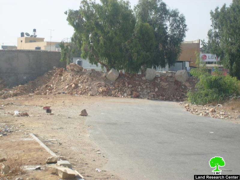
Photos 3&4: Azzun’s northern entrance which has been closed since August, 2008
 
Background to Azzun
The town is located between the cities of Nablus and Qalqiliya on road number 55 at the distance of 9 km east of Qalqiliya city. Azzun’s total surface land area is 9140 dunums of which 1054 dunums designated as built up area. Around 276 dunums of Azzun’s land ( 3% of the total area) were confiscated for the construction of the two colonies of Ma’ale Shomron and Ginat Shomron.
 
The town’s total population at the end of 2007 was 7821.
 
Azzun’s town is located in the centre of  a number of villages as followed:
From North: Sir, Jayyus, Kafer Jamal, Kafer Abush, Kafer Zeybad and Kafr Sur;
From South: Kafr Thuluth, Siniriya, Masha, Bidya and Az Zawiya;
From west: Nabi Eliya and Asala;
From east: Kafer Laqif, Jinsafut, Hajja, Baget Al Hateb, Imatin, Farta’a, Jit Kafr Qadum, Sura.
 
Related case studies: 
1.     Palestinian Lands Transformed into Dumping Sites for Colonists’ Waste, 13,March,2009.
2.     Israeli Occupation Army block Azzun Al Shamaliya village’s main entrances 18,November,2008.
3.     The Closure of Northern Azzun’s remaining entrances 12,May,2008.


Prepared by:
The Land Research Center
LRC

Recommended For You

إقامة منطقة عسكرية عسكرية داخل أراضي (أ) في جنين

by arij
May 19, 2026
0
إقامة منطقة عسكرية عسكرية داخل أراضي (أ) في جنين

   في السابع من شهر أيار من العام 2026، وزعت سلطات الاحتلال الإسرائيلي أمرا عسكريا جديدة على أهالي مدينة جنين يقضي بمصادرة 7.2 دونما من الأراضي الفلسطينية في...

Read moreDetails

“بمساحة اجمالية 177 دونما من أرضي البيرة وبيتين”, طريق استيطاني لخدمة البؤر الاستيطانية في محافظة رام الله

by arij
May 18, 2026
0
“بمساحة اجمالية 177 دونما من أرضي البيرة وبيتين”, طريق استيطاني لخدمة البؤر الاستيطانية في محافظة رام الله

في الحادي عشر من شهر أيار من العام 2026, نشرت دائرة أراضي إسرائيل اعلانا جديدا يقضي بمصادرة المزيد من الأراضي الفلسطينية في محافظة رام الله لأغراض استيطانية في...

Read moreDetails

“في خدمة مستوطنة ناحال حيلتس”, طريق استيطاني إسرائيلي جديد على أراضي بتير وبيت جالا في محافظة بيت لحم

by arij
May 18, 2026
0
“في خدمة مستوطنة ناحال حيلتس”, طريق استيطاني إسرائيلي جديد على أراضي بتير وبيت جالا في محافظة بيت لحم

تواصل سلطات الاحتلال الإسرائيلي إحكام سيطرتها على المزيد من الأراضي الفلسطينية في الضفة الغربية المحتلة، وهذه المرة من خلال استهداف أراضي محافظة بيت لحم. ففي السادس والعشرين من...

Read moreDetails

مناطق نفوذ المستوطنات ودورها في إعادة تشكيل الجغرافيا الفلسطينية

by arij
April 23, 2026
0
مناطق نفوذ المستوطنات ودورها في إعادة تشكيل الجغرافيا الفلسطينية

أصدرت سلطات الاحتلال الإسرائيلي في العاشر من شهر نيسان 2026 الكراسة رقم (273)، وهي وثيقة تضم مجموعة من المناشير والأوامر والتعيينات الإسرائيلية المتعلقة بالجوانب الأمنية والعسكرية والإدارية، إضافة...

Read moreDetails

INFOGRAPHIC: Mapping Control – Israeli Militray Orders across the occupied West Bank – 2025

by arij
April 16, 2026
0

    Prepared by:   The Applied Research Institute – Jerusalem

Read moreDetails
Next Post

The Plowing of Palestinian Lands in the Towns of Halhul and Beit Ummar in Hebron Governorate for the Benefit of the Colony of Karmi Tzur.

LATEST NEWS

إقامة منطقة عسكرية عسكرية داخل أراضي (أ) في جنين

إقامة منطقة عسكرية عسكرية داخل أراضي (أ) في جنين

by arij
May 19, 2026
0

........................................................

النكبة الفلسطينية في ذكراها الثامنة والسبعين: من التطهير العرقي إلى الإبادة وإعادة هندسة الجغرافيا الفلسطينية 

النكبة الفلسطينية في ذكراها الثامنة والسبعين: من التطهير العرقي إلى الإبادة وإعادة هندسة الجغرافيا الفلسطينية 

by arij
May 18, 2026
0

........................................................

“بمساحة اجمالية 177 دونما من أرضي البيرة وبيتين”, طريق استيطاني لخدمة البؤر الاستيطانية في محافظة رام الله

“بمساحة اجمالية 177 دونما من أرضي البيرة وبيتين”, طريق استيطاني لخدمة البؤر الاستيطانية في محافظة رام الله

by arij
May 18, 2026
0

........................................................

“في خدمة مستوطنة ناحال حيلتس”, طريق استيطاني إسرائيلي جديد على أراضي بتير وبيت جالا في محافظة بيت لحم

“في خدمة مستوطنة ناحال حيلتس”, طريق استيطاني إسرائيلي جديد على أراضي بتير وبيت جالا في محافظة بيت لحم

by arij
May 18, 2026
0

........................................................

flag_yellow_lowEU-PfP-Logo

This website and its content were initiated in 1993 by the Applied Research Institute – Jerusalem (ARIJ) and the Land Research Center (LRC) with the support from the European Union up until 2023. Since then, the Applied Research Institute – Jerusalem (ARIJ) has taken over the continued development and maintenance of the website. The views expressed remain solely those of ARIJ) and do not necessarily reflect those of the European Union.

© 2026 Copyright | ARIJ | All Rights reserved.

No Result
View All Result
  • Home
  • Settlements
    • New Israeli Settlements
    • Settlement Expansion
  • Israeli Violations
    • Agriculture
    • Confiscation
    • Demolition
    • Environment
    • Eviction of Palestinians
    • Settlers Attacks
  • Bypass Roads
  • Israeli Plans
  • Segregation
    • Checkpoints
    • Closure
    • Separation Plans
  • Military Orders
  • Reports
    • Daily Report
    • Monthly Report
    • Quarterly Report

© 2026 Copyright | ARIJ | All Rights reserved.