• About The Project
  • Palestine in Century
  • Selected Maps
  • Glossary
  • About ARIJ
  • About LRC
  • By Year
    • Case Studies By Year
    • Daily Report By Year
Friday, May 9, 2025
POICA
No Result
View All Result
  • Home
  • Settlements
    • New Israeli Settlements
    • Settlement Expansion
  • Israeli Violations
    • Agriculture
    • Confiscation
    • Demolition
    • Environment
    • Eviction of Palestinians
    • Settlers Attacks
  • Bypass Roads
  • Israeli Plans
  • Segregation
    • Checkpoints
    • Closure
    • Separation Plans
  • Military Orders
  • Reports
    • Daily Report
    • Monthly Report
    • Quarterly Report
No Result
View All Result
POICA
No Result
View All Result

Israeli Occupation Authorities Intend to Construct a Sewage Pipe for Ariel Colony

August 4, 2009
in Settlement Expansion
Israeli Occupation Authorities Intend to Construct a Sewage Pipe for Ariel Colony

Israeli occupation authorities declared its intention to establish a sewage pipe for the benefit of the colony of Ariel north of the West Bank. The Infrastructure Department in the so-called “Civil Administration” published in June 2009 that it is in the process of the establishment of a 3.5-kilometer pipe to transfer Ariel’s sewage and wastewater. The pipe is planned to go through the villages of Kufl Harith (2 kilometers) and Marda (1.5 kilometers). The pipe will start from the main sewage network inside the colony of Ariel and ends in a sewage collection pool located in the northwestern side of the colony.

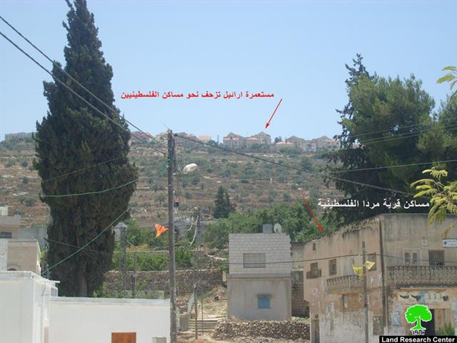
Photo 1: The Israeli colony of Ariel creeping over the lands of the Palestinian village of Marda.


The Negative Impact of the Pipe:

  • The confiscation of 20 dunums of agricultural lands that belongs to the following; Adnan Abdel Khaleq Bozeia, Yousef Abdel Khaliq Bozeia (of Kufl Harith) and Nusfat Al Khafsh and Mohammand Ahmad Al Khafsh (of Marda). Access to these lands will subsequently be prohibited.

  • The decision to establish the pipe comes at the same time that Israeli occupation forces have prevented Salfeet Municipality from constructing a wastewater treatment plant. Work on the plant was embarked upon as early as 1999 when the Municipality began the construction of the plant in Al Matwi area west of the city. However, the plant was stopped by Israeli forces under the pretext that the plant was constructed in Area C without obtaining the necessary permits. When the Salfeet Municipality took the needed steps to gain such permits, the Israeli “Civil Administration” refused to grant the Municipality the required permit and, instead, suggested to build a Palestinian-Israeli treatment plant that would also serve the colony of Ariel. The suggestion was met with fierce opposition from Palestinian authorities and NGOs on the premise that the colony of Ariel is an illegal entity built on occupied Palestinian lands. The Municipality, therefore, searched for another location in Area B that was 500 meters away from the old location as the need for such a plant is of greater importance. However, when construction started, donors were not in a hurry to fund it as its new location meant additional costs that no one agency wanted to bear. The problem is still not resolved as the Israeli occupation is considered to be the biggest obstacle preventing the construction of the plant.

Ariel Colony: General Information and History of Violations

The colony of Ariel was established in 1978 at about 22 kilometers east of the Green Line. It is connected to the Israeli proper via Trans-Samaria Road 5. The built-up area of the colony is 5226 dunums and its population is 16,053. It was established atop lands confiscated from the villages of Marda, Iskaka, Salfeet and Kufl Haris.The colony is considered the second largest colony in the West Bank as Ma’ale Adumim is the largest.


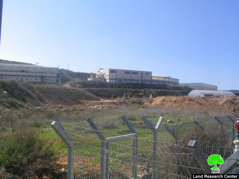
Photos 2,3,4: The Colony of Ariel


Israeli occupation forces started in 2003 to construct the Racist Isolation Wall around the colony in the Governorate of Salfeet. Thousands of dunums from the villages of Iskaka, Marda and Kufl Haris and the city of Salfeet were plowed while hundreds of trees were uprooted to make way for the Racist Wall. That was despite the fact that the Israeli so-called “High Court of Justice” has issued a number of court decisions to stop work on the Racist Wall around the colony due to a number of legal complaints filed by the residents of the said affected communities.


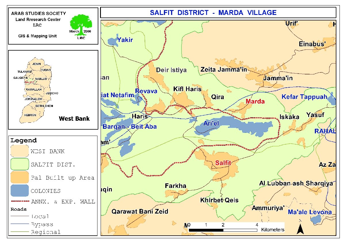
In July 2005, the Israeli Ministry of “Defense” declared its intention to build the so-called “Ariel Fingers” which were sections of the Wall surrounding the colony at a distance of 22 kilometer east of the Green Line. If it goes as planned, the Fingers would capture 120,000 dunums of Palestinian lands while annexing Israeli colonies surrounding Ariel (including Rafafa, Burqan, Kiryat Natafeim, Amanaoeil, and Ma’ale Shomron) into Israel. According to B’Tselem, the idea of the Fingers was dropped in early 2008. Instead, a series of buffer zones around each colony surrounding Ariel were constructed.


The real danger of the sewage and wastewater flowing from the colony of Ariel to Palestinian lands in the cities of Salfeet, Broqin and Kufr Al Deek stems from the fact that it pollutes the beautiful environment and causes depression due to the awful odor it produces. Moreover, the plants and sheep that eat it are prone to food poisoning which, in turn, would be passed on to humans with varying degrees and effects. In addition, there is a real possibility that the wastewater would seep into the underground water causing its pollution as well as the pollution of cisterns and spring from which Palestinians drink. 


It is worth pointing out that the environmental devastation caused by the colony of Ariel was addressed by a number of Palestinian and international organizations. Yet, the situation on the ground did not change. In all actuality, the situation has become even worse and it is expected to get even worse as Israeli occupation authorities are contemplating the expansion of the colony. For additional information regarding the colonies of Ariel and Burkan, please click here and here.

:::::::::_

[1] LRC’s GIS UnitS

[2] The Palestinian DCL in Salfeet


Prepared by:
The Land Research Center
LRC


Recommended For You

إسرائيل تمضي قدمًا في مخطط استيطاني جديد على أراضي مدينة بيت جالا، في انتهاك للقانون الدولي وحرمان الفلسطينيين من أراضيهم

by arij
April 29, 2025
0
Israel Advances Settlement Plan on Ancient Olive Groves on lands of Beit Jala city, Violating International Law and depriving Palestinians their lands

  في أواخر شهر شباط من العام 2025، صادقت دولة الاحتلال الإسرائيلي على مخطط استيطاني جديدة لبناء حي سكني للمستوطنين على مساحة 22.2 دونما من الأراضي الفلسطينية لتابعة...

Read moreDetails

سلطات الاحتلال الإسرائيلي تصادر 64 دونما شمال مدينة بيت لحم لإقامة موقفا للحافلات

by arij
October 19, 2023
0
سلطات الاحتلال الإسرائيلي تصادر 64 دونما شمال مدينة بيت لحم لإقامة موقفا للحافلات

  في السابع من شهر أيلول من العام 2023, صادقت بلدية الاحتلال الإسرائيلي في القدس المحتلة على مخطط استيطاني جديد من شأنه أن يصادر مساحات شاسعة من أراضي...

Read moreDetails

Israeli Settlements in the Occupied West Bank: from “outposts” to urban blocks

by arij
May 20, 2023
0
Israeli Settlements in the Occupied West Bank: from “outposts” to urban blocks

  The Applied Research Institute – Jerusalem (ARIJ) In cooperation with Palestine Economic Policy Research Institute (MAS)   Preface Legalizing nine Israeli settlement outposts in the occupied West...

Read moreDetails

استكمال انشاء حي استعماري تابع لمستعمرة ” الكانا” على أراضي قرية مسحة / محافظة سلفيت

by arij
November 1, 2022
0
استكمال انشاء حي استعماري تابع لمستعمرة ” الكانا” على أراضي قرية مسحة / محافظة سلفيت

  الانتهاك: توسع استيطاني. الموقع: قرية مسحة / محافظة سلفيت. تاريخ الانتهاك: تشرين أول 2022. الجهة المعتدية: مستعمرة " الكانا". الجهة المتضررة: أهالي قرية مسحة.  تفاضيل الانتهاك:   استكمل...

Read moreDetails

بواقع “4,762 دونما”, سلطات الاحتلال تصادق على عددا من المخططات الاستيطانية منذ بداية شهر تشرين أول 2022

by arij
October 19, 2023
0
بواقع “4,762 دونما”, سلطات الاحتلال تصادق على عددا من المخططات الاستيطانية منذ بداية شهر تشرين أول 2022

  كشفت سلطات الاحتلال الإسرائيلي منذ بداية شهر تشرين الأول من العام 2022, عن مصادقتها لعددا من المخططات الاستيطانية في عددا من المستوطنات الإسرائيلية في الضفة الغربية المحتلة....

Read moreDetails
Next Post
سلطات الاحتلال تعلن عن  نيتها  إنشاء شبكة للمياه العادمة لصالح مستوطنة ارائيل

سلطات الاحتلال تعلن عن نيتها إنشاء شبكة للمياه العادمة لصالح مستوطنة ارائيل

LATEST NEWS

الأراضي الفلسطينية بين الذرائع الأمنية والأطماع الاستيطانية – “الأمن، الآثار، والطبيعة كحجج لاقتلاع الفلسطينيين من أراضيهم”

by arij
April 15, 2025
0

........................................................

الطرق الالتفافية الاسرائيلية وأثرها على البيئة الفلسطينية

انتهاك للطبيعة والهوية في الأراضي الفلسطينية المحتلة

by arij
March 17, 2025
0

........................................................

Israel Advances Settlement Plan on Ancient Olive Groves on lands of Beit Jala city, Violating International Law and depriving Palestinians their lands

إسرائيل تمضي قدمًا في مخطط استيطاني جديد على أراضي مدينة بيت جالا، في انتهاك للقانون الدولي وحرمان الفلسطينيين من أراضيهم

by arij
April 29, 2025
0

........................................................

Israel Advances Settlement Plan on Ancient Olive Groves on lands of Beit Jala city, Violating International Law and depriving Palestinians their lands

Israel Advances Settlement Plan on Ancient Olive Groves on lands of Beit Jala city, Violating International Law and depriving Palestinians their lands

by arij
April 29, 2025
0

........................................................

flag_yellow_lowEU-PfP-Logo

This website has been produced with the assistance of the European Union. The contents of this publication are the sole responsibility of ARIJ & LRC and can in no way be taken to reflect the views of the European Union.

© 2025 Copyright ARIJ . All Rights reserved. .

No Result
View All Result
  • Home
  • Settlements
    • New Israeli Settlements
    • Settlement Expansion
  • Israeli Violations
    • Agriculture
    • Confiscation
    • Demolition
    • Environment
    • Eviction of Palestinians
    • Settlers Attacks
  • Bypass Roads
  • Israeli Plans
  • Segregation
    • Checkpoints
    • Closure
    • Separation Plans
  • Military Orders
  • Reports
    • Daily Report
    • Monthly Report
    • Quarterly Report

© 2025 Copyright ARIJ . All Rights reserved. .