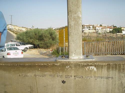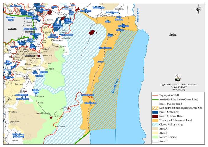
On June 28, 2009, the Land Registry Office at Ma’ale Adumim settlement published 12 public notices in the local Palestinian Al Quds newspaper for the registration of 139000 dunums located along the northern and western shores of the Dead Sea to the property of the custodian of state land of Israel. The public notices requested that any individual or entity affected by the registration process is entitled to file an objection to the Beit El District coordination office within 45 days; even though the Israeli Land Registry will not deal with any objection (if any) on this regard as consider themselves the rightful heirs and owners of all the public lands of the State of Israel, including lands in the West Bank area. In fact this Israeli procedure is not new, rather, its been adopted by Israel for decades as it worked throughout the years of Occupation to transfer Public Palestinian lands to the property of the Israeli State lands after they are classified abandoned or common lands as in the case of the lands adjacent to the Dead Sea shores. See Map 1

Hence, the Question on this regard, what impels Israel to take such a step, which is only another means to extend and force its control over Palestinian lands. The answer is in the following points:-
1- To redefine the Legal status of the lands: in this regard, it should be noted out that the targeted lands are classified as ‘C’ and fall under the full Israeli control according to OSLO II Interim agreement which was signed by the Palestine Liberation Organization (PLO) and Israel in September 1995. Israel has sought for decades to redefine the legal status of all public and State lands as identified prior the 1967 war when it was under the Jordanian Administration, to ‘abandoned lands’ where the Occupying State (Israel) may later on redefine them to ‘State Lands’ under the control of the Israeli Occupation State. Israel’s goal behind doing so is to pre-empt any future Negotiations with the Palestinians over these lands (classified as ‘C’) to retain control over part of it or bargain on these land to gain control over more lands in other areas in the West Bank; particularly, lands located between the 1949 Armistice Line (Green Line) and the route of the Israeli Segregation Wall.
2- Tightening the Israeli Grip on the shores of the Dead Sea: in this regard, it is worth mentioning that the Palestinian water rights for the exploitation of the Dead Sea which include but not limited to, investment or recreational, has been eliminated by Israel despite what have been agreed upon on this issue during Oslo agreement. The fact is that the Palestinians has rights to 194 Km2 of the Dead Sea; and the registration of the lands adjacent to the Dead Sea shores will deny the Palestinians their rights to access it and/ or use it as well. In other words, if Israel succeeds to pass on this registration of the targeted lands from area ‘C’ lands to State lands, Palestinians stands to lose their rights at the Dead Sea area, which mounts up to almost 2.5% of the West Bank area and turn any ‘possible’ future negotiations over ‘Rights Issue’ from negotiation of rights to ‘Pleading and Bargaining’ issue.
3- Elimination of geographical contiguity concept for a Palestinian State: if Israel succeed to register the targeted lands in the public notices to State Lands it will realize its objective to break the geographical contiguity between the northern and southern parts of the West Bank, which means that Palestinians travelling from south to north and vise versa would go through an Israeli controlled territory. This mutated situation conform with the Israeli Segregation Wall plan which encircles occupied East Jerusalem from three directions and isolates it from the rest of West Bank Governorates, as the targeted lands amalgamate with the Segregation Wall around Ma’ale Adumim settlements’ bloc, And forms a physical and geographical barrier of Israeli controlled territory all the way to the Dead Sea shores and the West Bank eastern border line. Such a formation is intended to push the Palestinians to agree to an Israeli proposal to link the northern and southern parts of the West Bank through the construction of underground tunnels and Palestinian bypass roads in areas controlled by Israel, which Israel has already planned and commenced work on, thus eliminating any possibility to establish a sovereign Palestinian state with territorial contiguity and this is what Israel has been seeking since its occupation of the Palestinian Territory back in 1967 to establish no-sovereign Palestinian state of ghettoes and cantons.
Therefore, it seems that the public notices published in the local Palestinian Al Quds newspaper for the registration of 139000 dunums located along the northern and western shores of the Dead Sea to the property of the custodian of state land of Israel is an embarking step for what is yet to come ahead and an expression of how Israel plans to counter the International pressure to halt settlements’ construction.
Israel has always conducted its negotiations with the Palestinians and the other countries it concluded peace treaties with based on a Trade-off code. As far as the Palestinian situation goes, Israel continues to come up with ways to evade the real issues, one time its comes up with a plan to freeze construction in some settlements in return for resuming construction at other major settlements’ blocs which Israel has already annexed west of the Wall (between the Segregation Wall and the 1949 Armistice Line- the Green Line), and repeatedly declared it will retain under any future agreement with the Palestinians.
Prepared by:
The Applied Research Institute – Jerusalem
The Applied Research Institute – Jerusalem