• About The Project
  • Palestine in Century
  • Selected Maps
  • Glossary
  • About ARIJ
  • About LRC
  • By Year
    • Case Studies By Year
    • Daily Report By Year
Saturday, May 10, 2025
POICA
No Result
View All Result
  • Home
  • Settlements
    • New Israeli Settlements
    • Settlement Expansion
  • Israeli Violations
    • Agriculture
    • Confiscation
    • Demolition
    • Environment
    • Eviction of Palestinians
    • Settlers Attacks
  • Bypass Roads
  • Israeli Plans
  • Segregation
    • Checkpoints
    • Closure
    • Separation Plans
  • Military Orders
  • Reports
    • Daily Report
    • Monthly Report
    • Quarterly Report
No Result
View All Result
POICA
No Result
View All Result

Plowing of Large Area of Palestinian Lands for the Benefit of Al Kana Colony

March 21, 2009
in Confiscation
Plowing of Large Area of Palestinian Lands for the Benefit of Al Kana Colony

Since the middle of February 2009 Israeli occupation forces began land plowing in the village of Masha, west of the Governorate of Salfeet, which is isolated behind the Israeli Racist Isolation Wall. The area of the plowed lands is about 22 dunums and is located in Parcel 4 (known as Ahwad Abu Zureiq). It is owned by both Mr. Ramadan Yousef Ibrahim A’amer and Mr. Sabah Abdel Kareem A’amer who were trying to gain access to their lands since 2004, yet to no avail as Israeli occupation forces continued to deny them this basic right.   

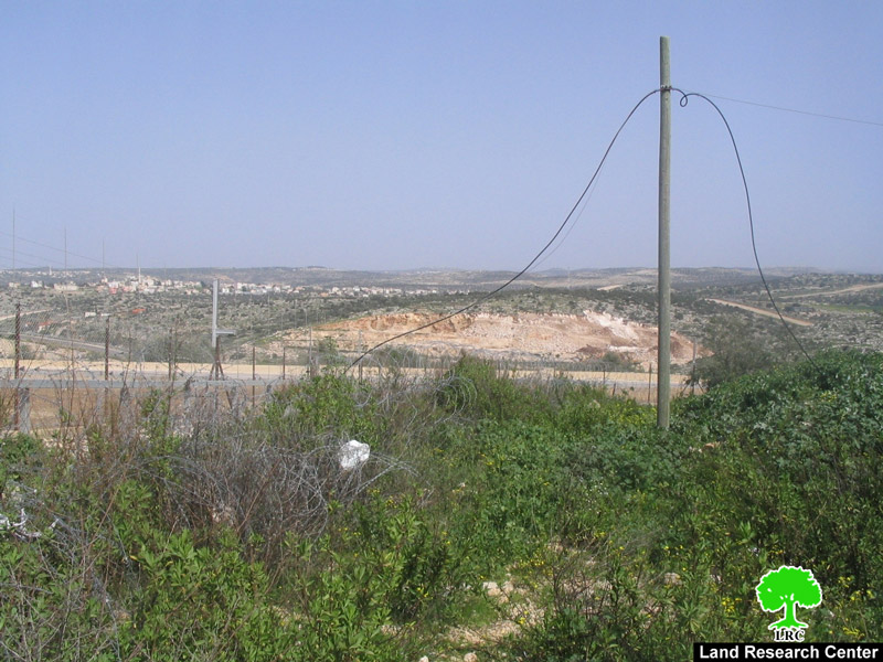
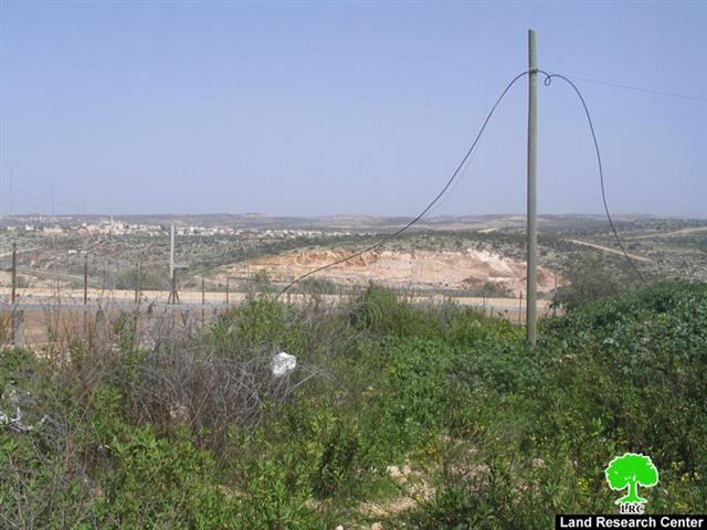
Photo 1: The plowed lands in Masha beyond the Electronic Fence.


The plowed lands were planted with olive trees and are considered to be a secondary source of income for the owners of the lands. The plowing has taken place in tandem with an ongoing major expansion of the nearby colony of Al Kana A and B especially in the southwestern direction of the colony. The current plowing, which is taking place only 400 meters away from the colony, coupled with the ongoing expansion is liable to increase the area of the colony to double its current size. It is worth noting that the colony of Al Kana was established in 1977. Its current area is 1198 dunums with a built-up area of 758 dunums in which 3050 colonists were living as of the year 2004.


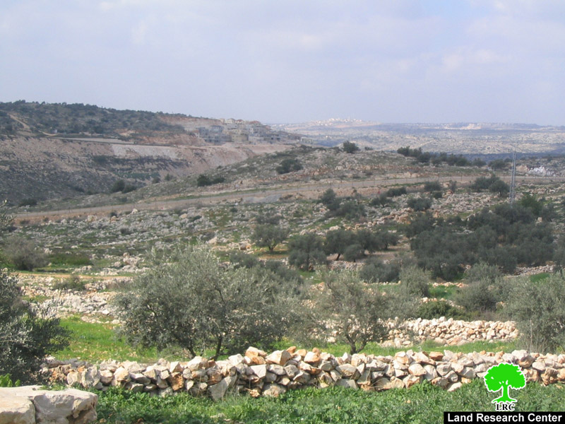
Photo 2 & Photo 3: Al Kana colony expanding on the expense of the lands of Masha village.


Since the establishment of the Racist Wall in Masha in 2004, Israeli occupation forces have tried to link the colonies located behind the wall with a network of roads as a prelude to gather them in one regional council in the future. These forces are taking advantage of the fact that Masha Palestinian land owners (around 400 according to UNRWA) cannot reach their isolated lands due to Israeli restrictions. Such restrictions include giving entry permit to only one person of the family in addition to placing impossible conditions on those wanting to be issued a permit to reach their isolated lands. This Israeli policy has led to a steep decrease in the number of Palestinian farmers that can gain access to their lands isolated beyond the Wall. Lack of access provided an alibi for the Israeli occupation forces to implement wide scale plowing for the benefit of the colonies of Al Kana A and B, Itsfariem, Oraniet and Shi’ar Batikva

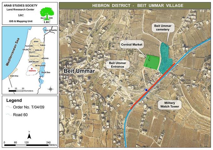
General Information About Masha:

The village of Masha is located 6 kilometers east of the Green Line at a distance of about 20 kilometers west of the city of Salfeet. Its lands extend up to the boundaries of the town of Biddya in the Governorate of Salfeet. Its population is estimated to be 2003. The village is considered to be the mother village of the town of Kufr Qasem which was occupied in 1948. In the aftermath of the 1948 Nakba, the Israelis occupied 70% of the village, including the Kufr Qasem location, while the remaining 30% stayed within the boundaries of the West Bank which later became the village of Masha. In 1956, a massacre was carried out by Zionist gangs against the residents of Kufr Qasem which caused the remaining ones to flee for their lives.   

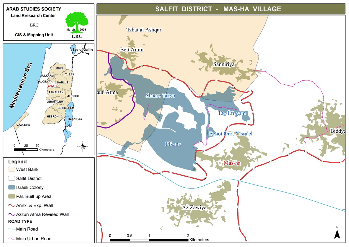
The total area of the village is 7,870 dunums of which 598.6 dunums are its built-up area while an additional 5272 dunums are used for agricultural purposes (vegetables, trees and olive trees). Around 1000 dunums are used for grazing purposes. 

Israeli colonies surround the village from all direction as they devoured around 2200 dunums of Masha lands. The colonies established upon Masha lands include:

  • The colony of Al Kana which confiscated 1373.5 dunums

  • The colony of Itsfariem which confiscated 539 dunums

  • The colony of Shi’ar Batikva whose area is 1130.5 dunums of which 283 dunums are Masha lands.

General Information About the Israeli Racist Isolation Wall in Masha:

The length of the Israeli Racist Wall in the lands of Masha is about 3 kilometers. It consists of a combination of 8-meter high slaps of cement, barbwires, and fences with electronic sensing devices as well as trenches. The width of the Wall varies between 40 to 50 meters.

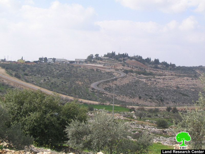
Photo 4: The barbwire stretching along the colonial road on Masha lands.


It is worthy to note that the establishment of the Israeli Racist Wall has led to the confiscation and the isolation of around 5500 dunums of Masha lands constituting 95% of its total area. Currently, the Racist Wall surrounds the village from its northern and western directions. The second phase of the construction of the Wall will be done in the southern parts of the village which, in turn, will turn the village into an isolated Palestinian community. It, also, would mean the transfer of its population from a productive workforce working in agriculture and trade into an army of poverty-stricken unemployed population. That is in addition to the lack of any possibility of further building expansion to absorb the future natural population growth. 


Prepared by:
The Land Research Center
LRC


Recommended For You

هدم وسرقة بيت تعبئة زراعي في كردلة – ضربة موجعة للاقتصاد المحلي

by arij
January 21, 2025
0
Demolition and Theft of an Agricultural Packing Facility in Kardala: A Severe Blow to the Local Economy

تفاصيل الانتهاك: منذ احتلال الضفة الغربية عام 1967، باتت قرية كردلة هدفًا رئيسيًا للاحتلال الإسرائيلي الذي يسعى بكل الوسائل لتفريغها من سكانها الأصليين، تمهيدًا للاستيلاء على أراضيها ومواردها....

Read moreDetails

Demolition and Theft of an Agricultural Packing Facility in Kardala: A Severe Blow to the Local Economy

by arij
January 20, 2025
0
Demolition and Theft of an Agricultural Packing Facility in Kardala: A Severe Blow to the Local Economy

Since the occupation of the West Bank in 1967, the village of Kardala has become on the list of the prime and major targets for the Israeli occupation,...

Read moreDetails

تستهدف ما يزيد عن6900, تسجيل الأراضي في القدس في خدمة مشروع الاستيطان الإسرائيلي وشرعنة الاستيلاء على الأرض

by arij
May 8, 2023
0
POSITION PAPER: A Land Mine before the “Two State Solution

   تسوية الأراضي هي أحدى اهم حيل إسرائيل لتهويد القدس الشرقية، وقد كان القضاء الإسرائيلي قد أصدر إعلاناً عن بدء "تسوية أراضٍ" بمسميات وأرقام جديدة للأحواض في احياء...

Read moreDetails

الاحتلال يصادر محتويات منتزه في جبل السنداس جنوب مدينة الخليل

by arij
September 14, 2022
0
الاحتلال يصادر محتويات منتزه في جبل السنداس جنوب مدينة الخليل

  الانتهاك: مصادرة مواد منتزه. تاريخ الانتهاك: 31/08/2022. الموقع: جبل السنداس/ مدينة الخليل. الجهة المعتدية: الإدارة المدنية التابعة للإحتلال. الجهة المتضررة: المواطن يسري الجمل. التفاصيل: أقدمت سلطات الاحتلال...

Read moreDetails

The Occupation Confiscates Properties of a Park Owner at Hebron City

by arij
September 15, 2022
0
الاحتلال يصادر محتويات منتزه في جبل السنداس جنوب مدينة الخليل

  Violation: Confiscation of park properties. Date: August 31st 2022. Location: As-Sindas Mountain / Hebron city. Perpetrators: The Israeli Civil Administration. Victims: Citizen Yusri Aj-Jamal. Description: Wednesday ,...

Read moreDetails
Next Post
A New Road Barrier to Close the Main Entrance of the Town of Beit Ummar

A New Road Barrier to Close the Main Entrance of the Town of Beit Ummar

LATEST NEWS

الأراضي الفلسطينية بين الذرائع الأمنية والأطماع الاستيطانية – “الأمن، الآثار، والطبيعة كحجج لاقتلاع الفلسطينيين من أراضيهم”

by arij
April 15, 2025
0

........................................................

الطرق الالتفافية الاسرائيلية وأثرها على البيئة الفلسطينية

انتهاك للطبيعة والهوية في الأراضي الفلسطينية المحتلة

by arij
March 17, 2025
0

........................................................

Israel Advances Settlement Plan on Ancient Olive Groves on lands of Beit Jala city, Violating International Law and depriving Palestinians their lands

إسرائيل تمضي قدمًا في مخطط استيطاني جديد على أراضي مدينة بيت جالا، في انتهاك للقانون الدولي وحرمان الفلسطينيين من أراضيهم

by arij
April 29, 2025
0

........................................................

Israel Advances Settlement Plan on Ancient Olive Groves on lands of Beit Jala city, Violating International Law and depriving Palestinians their lands

Israel Advances Settlement Plan on Ancient Olive Groves on lands of Beit Jala city, Violating International Law and depriving Palestinians their lands

by arij
April 29, 2025
0

........................................................

flag_yellow_lowEU-PfP-Logo

This website has been produced with the assistance of the European Union. The contents of this publication are the sole responsibility of ARIJ & LRC and can in no way be taken to reflect the views of the European Union.

© 2025 Copyright ARIJ . All Rights reserved. .

No Result
View All Result
  • Home
  • Settlements
    • New Israeli Settlements
    • Settlement Expansion
  • Israeli Violations
    • Agriculture
    • Confiscation
    • Demolition
    • Environment
    • Eviction of Palestinians
    • Settlers Attacks
  • Bypass Roads
  • Israeli Plans
  • Segregation
    • Checkpoints
    • Closure
    • Separation Plans
  • Military Orders
  • Reports
    • Daily Report
    • Monthly Report
    • Quarterly Report

© 2025 Copyright ARIJ . All Rights reserved. .