
After the 1967 war, Israel came to occupy the Palestinian West Bank and Gaza; hence, a military rule over these areas became a de facto reality because of this occupation. In 1968, the Israel Army immobilized all the land registration procedures to alienate the Palestinians from their land, and to disqualify them in a legal manner from using it or make any effective changes to the status of their urban areas. In the late 1970’s, the Israeli Army established the so-called “Israeli Civil Administration” which was given to handle administrative, legislative, and managerial authorities, which proved to be one of the most powerful mechanisms of the Israeli Army in the occupied Palestinian territory (OPT). The Israeli civil administration has created two discriminating systems of law in the OPT; basing the rights of individuals living there (Palestinians and illegal Israeli settlers) on their nationality, thus there was one law for Jews settlers and another for Palestinians under occupation. These two different laws operate on two distinct tracks: one for Jews and the other for Palestinians. The Israeli Civil Administration passed on many planning jurisdictions to the Jewish local authorities, which are the settlements, at the same time; it denied the Palestinians such rights; hence, planning and building Jewish settlements went on uninterrupted, while planning and development of Palestinian communities was infrequent to virtually nil in most of the OPT. The Israeli civil administration based its non-conforming decision with regard development of Palestinian areas on the regional outline plans – approved in the 1940s during the British Mandate time, which prohibit construction in such areas.
As a result, the Israeli civil administration forced upon the Palestinians to obtain a building permit from them, especially those Palestinians seeking to build houses outside of the existing community boundary as defined by the approved regional outline plans during the British Mandate time, otherwise, these house are rendered illegally built and are subject to demolishing by the Israeli civil Administration, even if they are built on private land.
In 2008, the Israeli planning Department operating within the Israeli Civil Administration decided to issue exclusive master plans for number of Palestinian villages located in areas of the West Bank defined under the Oslo Accordof 1995 as area 'C' . This shift in the Israeli civil administration policy came because of effective pressure – or just Israeli pacifying to – from the international Quartet and the Office of its delegate Tony Blair.
However, and regardless of the drive behind this change of attitude on the Israeli side, the master plans presented by the Israeli civil administration for the selected Palestinian communities located in are “C” did not meet the minimum needs and shortages of Palestinian communities, in addition to that the suggested master plans by the Israeli civil administration did not take into consideration the current status of the communities nor its future needs.
Background (Timeline of the problem
Sovereignty of the occupation power over the occupied territories is a dismissed concept by the international law of armed conflict. The authority practiced by the occupation does not consent it a domination over the land it occupy and certainly does not allow the occupation to annex any part of the land to its jurisdiction nor transfer parts of its population to the territory it occupy. The consecutive Israeli governments adopted a policy to acquire much of the West Bank lands to build and expand the Israeli settlements by employing different methods; most recognized of which, “Security,” which is also how Israel was able to restrict Palestinian towns’ development on the remaining areas.
After Israel occupied the West Bank in 1967, it has implemented physical and administrative policies aimed to seize the Palestinian lands and dividing the West Bank. With respect to land confiscation, Israel used the Ottoman land law of 1858, which allows the state to expropriate fallow lands. Regarding urban planning, Israel used the Jordanian Regulatory 1966 low and regional master plans prepared by the British Mandate between the years 1940 – 1947.
Israeli Illegal annexation of Palestinian Territories
Sovereignty of the occupation power over the occupied territories is a dismissed concept by the international law of armed conflict. The authority practiced by the occupation does not consent it a domination over the land it occupy and certainly does not allow the occupation to annex any part of the land to its jurisdiction nor transfer parts of its population to the territory it occupy. The consecutive Israeli governments adopted a policy to acquire much of the West Bank lands to build and expand the Israeli settlements by employing different methods; most recognized of which, “Security,” which is also how Israel was able to restrict Palestinian towns’ development on the remaining areas.
Moreover, Israel has devised its own set of laws based by tailoring different procedures to acquire Palestinian lands based on ratified ottoman and Jordanian laws and even though all the consecutive Israeli governments adopted the settlement policy in the occupied Palestinian territory, each had a different approach to realize their shared objective and that to maintain the settlement program constantly active. The following methods employed by Israel over the years for the acquisition of Palestinian lands for the Israeli settlements and other purposes.
1. Acquisition by Declaring “State Land”
2. Acquisition by Declaring “Abandoned Land”
3. Acquisition by Declaring “Lands for Military Purposes”
4. Acquisition by Declaring “Closed Military Zones”
5. Acquisition by Declaring “Expropriation for Public Services”
Accordingly, between the years 1979 and 1992 Israel managed to confiscate more than 700,000 dunums. Furthermore, Israel was able to confiscate all the non-registered land, which has no Ottoman and/ or Jordanian Tabo.
When Israel occupied the West Bank in 1967, only one third of the land was registered to the people while the remaining two thirds of land ownership was proven by a Turkish issued Tabo (certificate of ownership) and an official British certificate/ registration. Purchase and/ or registrations of land made under Jordanian law prior to 1967 are also valid deed of land ownership. Fundamentally, the Ottoman land code (law) continue to govern the land holdings in the West Bank even with amendments passed during the Jordanian rule and the Israeli military orders issued since the 1967 occupation. The Ottoman land code had three main categories to classify the lands:
A) Waqf Land: Lands owned by religious bodies.
B) Mulk & Khuraj Lands: Mulk lands assigned by the Ottoman rule of the area which perceived itself as the ultimate owner by the fact of conquest to all occupied lands; to Muslim residents of the occupied area while the Khuraj lands assigned to non-Muslim residents.
C) Miri/ Matruk & Mawat Lands: These lands were all unregistered and considered by Israel as a State property and they cover the majority of the lands. The Miri lands are those, which belonged to Al-Amir or the Prince of the county and were not dedicated to any segment of the society. The Matruk lands were those lands dedicated to public usage (lands, building, etc) as for the Mawat lands; it indicated the lands remotely located from urban areas.
The objection committee is the only authority entitle to question the declaration of lands classified as “State Lands” and since it is controlled and administered by the Israeli military it had been impossible to alter any declaration which is made in the first place by the same source. The Israeli high court has also distant itself from the issue after its infamous ruling on the Elon Moreh case that constituted an official outbreak of the settlement program in 1979 by declaring that it will not intervene in any lands disputes unless the land in subject of seizure is privately owned. The Israeli military has arranged to acquire Palestinian lands for the Israeli settlements and controlled all procedures to cast off the objection appeals made by the Palestinian residents against any acquisition order, which paved the way for the Israeli Army to acquire- to confiscate- more than 980,000 dunums of Palestinian lands in West Bank, which was unregistered in Tabo following the 1967 occupation. Collectively, Israel has confiscated 1.3 Million Dunums of West Bank lands, which is equivalent to 30% of the West Bank total area.
What is more, Israel used the regional British Mandate Master Plans (RJ/5 for southern West Bank and S/15 for northern West Bank) to issue building permits for the Palestinians in the West Bank. It should be noted at this point that the British master plans originated in the forties of last century intended to apply for a term of five years only.
Furthermore, Israel employed the 1966 Jordanian law for Urban Planning in the West Bank in limited fashion, until it tailored the law in March 23, 1971 with the military order No. 418, changing its main features in the following manners:
-
Changing the implementation bodies of the law from Jordanian to Israeli bodies
-
Military Order No. 418 aimed for the fragmentation of the West Bank territory. It made the Palestinian villages to follow the British master plans, while the order identifies the Israeli settlements areas as an area for development. It also prevents Palestinians from developing their residential areas.
-
The new military order canceled the role of local authorities and bodies in the planning process of their communities –including building licensing and authorization- and transformed that right over into the hands of the regional planning committees and the higher planning council within the Israeli Army operating under the name ”Villages Planning Committee' and headed by Israeli Army officers .
-
The military order had also originate planning commission called 'the Subcommittee for planning and inspections' which is designated to the well benefit and interest of the Israeli settlers’ population, with no regard to the interests of the indigenous Palestinian population.
-
The military order gave new jurisdiction authorities to the Israeli Army’s districts commander in chief, which includes the authority to appoint special planning committee for the development of Israeli settlements, and jurisdiction of regional planning commission.
Hence, it is right to conclude that that these British schemes did not take into account the immediate and future development needs to cope with the Palestinian population growth, which had multiplied several times since then, and the Israeli civil administration did not make it a priority as it aimed to keep the Palestinian population confined within controllable limits; thus rarely and under special circumstances when it usually meets its goals as well that they accepted to revise the existing plans in certain and limited locations. As a result, houses built by Palestinians without building permits are demolished by the Israeli civil Administration, even if they are built on private land.
Between 1967 and 1987, Israel was able to control the occupied Palestinian territory and prevent any new construction do not meet the aforementioned regulations. Between 1987 – 1990, the Israeli civil administration issued 19 special master plans for certain Palestinian communities, but these plans did not meet the development plans of these Palestinian communities as it only covered the built-up areas, which makes it quite obvious that the real intention was to confine the communities’ development.
Between 1990 and 1995, the Israeli civil administration issued some 400 special master plans for Palestinian communities all over the West Bank- all of which were based-drawn from the British mandate regional master plans RJ/5 and S/16-, which are no longer sufficient to meet the Palestinian needs as it only covered the built-up areas of these communities.
Moreover, there where many mistakes in submitted master plans, for example; one master plan integrated lands of two communities and at other places; the other way around where two master plans were issued for one community. Furthermore, any Palestinian constructions existed outside these master plans were subject to demolishing by the Israeli Civil Administration. Table 1 below shows a comparison between number of theses master plans area and the built-up area in some Palestinian communities.
|
|
The Palestinian community |
Built-up area Dunums |
Master plan area Dunums |
Dunums increase |
|
1 |
Bel'in |
265 |
266 |
1 |
|
2 |
Budros |
150 |
185 |
35 |
|
3 |
An-Nabi Elias |
75 |
87 |
12 |
Resource: Bimkom, Planners for planning rights
With respect to Israeli settlements, planning and construction was an open end process for the Israeli settlements’ councils and in 1991, the Israeli civil administration designated master plans for the Israeli settlements spread throughout the OPT, which stood then as a built-up area at 71 km square (1.25%) of the West Bank area and designate them a master plan area of 498 km square (8.8%) as of the West Bank area.
In 2008, the Israeli planning Department operating within the Israeli Civil Administration decided to issue exclusive master plans for number of Palestinian communities because of effective pressure – or just Israeli pacifying to – from the international Quartet and the Office of its delegate Tony Blair.
14 New master plans in area 'C':
Under pressure from the international Quartet and the Office of its representative Tony Blair, the Israeli civil administration agreed to issue new special master plan for 14 communities in area 'C' in the West Bank. Table 2, map 1 below list, and show the 14 villages.
|
Village |
Population 2007 |
District |
|
Jurt ash Sham'a |
10,378 |
Bethlehem |
|
Jabal Harsa |
17,200 |
Bethlehem |
|
Harmala |
846 |
Bethlehem |
|
A-Shek West |
285 |
Bethlehem |
|
Tarqumiya |
16,476 |
Hebron |
|
Idhna |
21,113 |
Hebron |
|
At Tuwani |
NA |
Hebron |
|
Ti'innik |
1,222 |
Jenin |
|
Umm ar Rihan |
417 |
Jenin |
|
Fasayil |
8,846 |
Jericho |
|
Rashida |
910 |
Ramallah, Jericho |
|
Bruqin |
4,086 |
Salfit |
|
Zharat Khabiriya |
2,204 |
Tulkarem |
|
Khirbet At Tayyah |
NA |
Tulkarem |
|
Total |
83,983 |
|
Resource: GIS Unit – ARIJ 2008

Tentatively, the suggested new master plans aim to reduce the dilemma of building without permits in Palestinian communities, claimed by the Israeli civil administration as illegal construction, thus to reduce the number of Palestinian houses under demolishing threat in area “C” where Israel enjoys absolute control. However, the new master plans schemes did not take into account the status on the ground with regard to Palestinian constructions at these communities. In the years from 2000 – 2007, there where 1890 submitted applications by Palestinians living in area “C” for building licenses to the Israeli civil administration, of which only 105 (5.5%) building permits approved. On the other hand, the civil administration demolished 1626 so-called illegal Palestinian structures in area C within the same period.
The main shortcomings of the proposed master plans
1- With regard to the planning staff: The submitted master plans came out as reflections to what the desire of the Israeli planning Department operating within the Israeli civil administration in a conform manner and harmonization with the military order 418 and according to the British mandate regional master plans RJ/5 and S/16 with minor modifications. Furthermore, the Palestinians and the local councils of the targeted communities were excluded from the planning process, which makes the new master plan simply another tract similar to precedents of master plans.
2- With respect to planning area: The boundary set for the communities in the new master plans’ scheme are considered the most important factor in the planning process, since it define the total area of the village and upon which the authorized construction sites determined and thus building permits are issued. Hence, it is only assumed that master plan would include areas with potentials for new expansion of the built-up area to cope with the ongoing population growth. Unfortunately, or unsurprisingly when considering the source, the new master plans did have such considerations as it covered only the built-up area in the above-mentioned villages with undersized expansion or even contraction. Table 3 below shows a comparison between the proposed master plans areas and the standing built-up area in the fourteen villages. The table also indicates the Built-up area outside the master plan.
|
Master Plan Name
|
Proposed Master plan Area / Dunum |
Existing total Built-up Area/ Dunums |
Built-up area inside the proposed master plan/ Dunums |
Built-up area outside the proposed master plan/ Dunums |
|
Jurt ash Sham'a |
143 |
169 |
28 |
141 |
|
Jabal Harsa |
99 |
62 |
41 |
21 |
|
Harmala |
164 |
80 |
55 |
25 |
|
A-Shek West |
161 |
61 |
41 |
20 |
|
Tarqumiya |
160 |
120 |
66 |
54 |
|
Idhna |
244 |
165 |
154 |
11 |
|
At Tuwani |
53 |
33 |
22 |
11 |
|
Ti'innik East Plan |
150 |
100 |
80 |
20 |
|
Approved Ti'innik Plan |
128 |
10 |
7 |
3 |
|
Umm ar Rihan |
81 |
30 |
29 |
1 |
|
Fasayil |
122 |
64 |
46 |
18 |
|
Rashida |
59 |
31 |
27 |
4 |
|
Bruqin |
188 |
172 |
87 |
85 |
|
Zharat Khabiriya |
93 |
104 |
40 |
64 |
|
Khirbet At Tayyah |
787 |
719 |
376 |
343 |
|
Total |
2632 |
1920 |
1099 |
821 |
Resource: GIS unit –ARIJ 2008
The Israeli proposed master plans have other fallouts, the standing constructions that were not included within the new boundary of the communities according to the new master plans and what will become of them? Are they considered illegal and be subject to demolishing? In fact, that is the greatest fear of the residents of these communities that the master plans will become with the official reference to identify what is legal and what is illegal and accordingly sanction demolishing orders against buildings constructed in the past outside the master plans. Another doubt to be addressed has to do with the fact that the Israeli civil administration has included within the new proposed master plans new open space areas and excluded simultaneously hundreds of dunums of built-up areas at these Palestinian communities. Will the Israeli civil administration allow Palestinian construction to take place at the new added open space areas? Who is the responsible body for issuing building permits in these newly added areas? Is it the PNA or the local councils of these communities? On the other hand, will the Israeli civil administration continue to be the executive body of administration over these communities? It is undoubtedly that such task will remain for the Israeli civil administration to handle, which means that no changes of significance will occur on the ground. The Civil Administration will continue to restrict new constructions in these newly added open space areas to the 14 communities.
The following maps 2 & 3 show two examples for two Palestinian communities in which the proposed master plans did not cover all the built-up areas and how that the newly added areas had no consideration for future population growth.
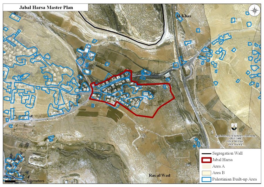
Map# 2: Jabal Harsa master plan
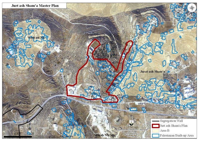
Map # 3: Jurt Ash-Sham'a master planResource: GIS Unit – ARIJ 2008
Elusive Planning
The proposed master plans by the Israeli civil administration had ambiguities to its overall purposes, and did not devoid planning errors. This indicates that planning policy adopted by the Israeli civil administration remained the same.
First: one of the targeted Palestinian communities Ti'innik has two sets of master plans, where the Israeli civil administration identified the first as “East Ti'innik” which has an area of 150 dunums, and encloses most of built-up area. The second master plan referred to as “Approved Ti'innik scheme” which has an area of 128 dunums and encloses most of the newly added open space area to the community in addition to some of the community’s built-up area. Map #4 shows the two master plans for Ti'innik.

Map #4: two master plans for Ti'innik village
Resource: GIS Unit – ARIJ 2008
Second: The Israeli proposed master plans are consciously oblivious of the current standing political classification of the West Bank (A, B, C) according to the Oslo II Accord. Some of the proposed master plans encompass part of the land that falls directly within the jurisdiction areas of the Palestinian Authority (area “A” & “B”) and sometimes in both. For example, parts of the master plans proposed for Harmala village include land classified 'B' (See map # 5). Part of Rashida village master plane located in area classified 'A' (See map # 6). In Khirbet At Tayyah part of the master plan, include lands from both areas A&B. (See map #7).
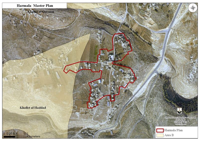
Map # 5: Harmalah village master plan
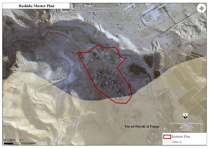
Map # 6 : Rashida village master plan
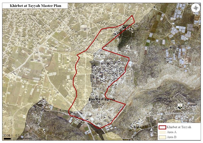
Map # 7 : Khirbet At Tayyah master plan
Resource: GIS unit – ARIJ 2008
Comparison with Israeli settlements master plans.
On the other hand, Israel made sure that the master plans assigned to the Israeli settlements in the OPT are well and sufficient to cope with anticipated future growth of settlers’ population, in addition to easily formulated procedures for building and development plans. According to the Israeli Central Bureau of Statistics, 18,472 housing units were constructed in Israeli settlements from 2000 until September 2007. At the same period of time, 4993 demolition orders were issued against Palestinian constructions in area “C” opposite to 2900 demolishing orders against illegal construction in the Israeli settlements, however, 1,663 (33%) of the demolishing orders were carried out against Palestinian structure in opposed to 199 (7%) in Israeli settlements in the same period of time. The following illustrate cases comparison between master plans designed for Palestinian communities in opposite to Israeli settlements.
1- Khirbat Umm Rayhan village vs. the near by Rehan settlement
|
|
Built-up area Dunums |
Master plan area Dunums |
Built-up area outside the master plan- dunums |
|
Umm Rayhan (Palestinian) |
30 |
81 |
1 |
|
Rehan (Israeli settlement) |
418 |
1739 |
0 |
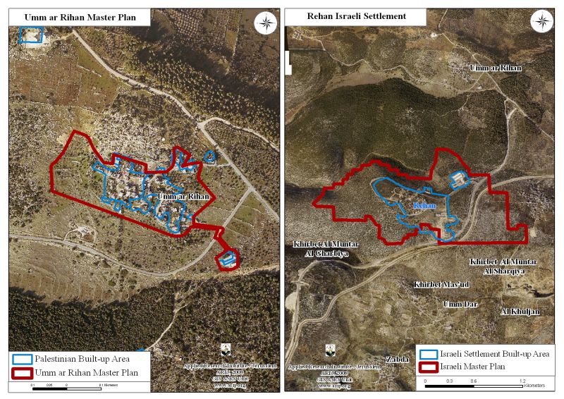
Map # 8: Comparison between Umm Rayhan Village and Rehan settlement
Resource: GIS Unit – ARIJ 2008
2- At-Twani village vs. the near by Ma'on settlement
|
|
Built-up area Dunums |
Master plan area Dunums |
Built-up area outside the master plan-Dunums |
|
At-Twani (Palestinian) |
33 |
53 |
11 |
|
Ma'on (Israeli settlement) |
683 |
854 |
0 |

Map # 9: Comparison between At-Twani Village and Ma'on settlement
Resource: GIS Unit – ARIJ 2008
3- Bruqin village vs. the near by Bruchin settlement
|
|
Built-up area Dunums |
Master plan area Dunums |
Built-up area outside the master plan- dunums |
|
Bruqin (Palestinian) |
172 |
188 |
85 |
|
Bruchin(Israeli settlement) |
328 |
955 |
0 |
4- Fassayil village vs. the near by Pezael settlement
|
|
Built-up area Dunums |
Master plan area Dunums |
Built-up area outside the master plan- dunums |
|
Fassayil (Palestinian) |
64 |
122 |
18 |
|
Fezael (Israeli settlement) |
5142 |
11369 |
0 |
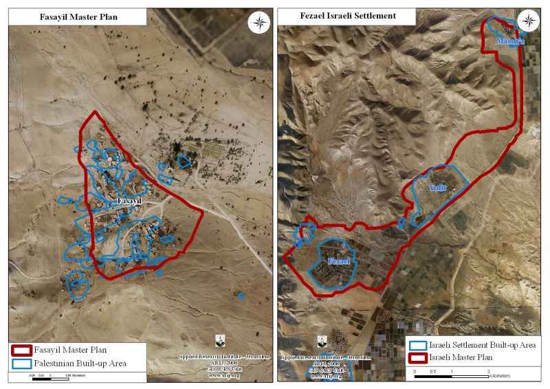
Map # 10: Comparison between Fasayel Village and Pesael settlement
Resource: GIS Unit – ARIJ 2008
To Conclude:
Over the past4+ decades of the ongoing Israeli occupation, Israel has stolen (literally describing what happened) hundreds of thousands of dunums of land from the Palestinians. Israel has used these lands to establish hundreds of illegal settlements in the West Bank and to populate them with hundreds of thousands of Israeli citizens. Israel uses the settlements to justify numerous violations of the Palestinians' human rights, such as the right to housing, to earn a livelihood, and the right to freedom of movement. The drastic change that Israel has coercively inflicted on the map of the West Bank prevents any real possibility for the establishment of an independent, viable Palestinian state as part of the Palestinians' right to self-determination. Without a doubt, these policies aim primarily to emptying the Palestinian population from area 'C'. The Israelis are planning to evacuate these areas voluntary and to transfer the Palestinian residents in a silent manner, without provoking international media. The Israeli military orders, which exceeded 2000-confiscation orders, deliberately designed to grab and rob Palestinian land in order to house illegal Israeli settlers, in contrary to the Israeli’s claims that the military orders are issued for security reasons as claimed by Israeli authorities.
Israel has systematically controlled the Palestinian territories to realize its colonization plan and settle their population in the occupied territory contrary to what the international law states. Article 49 of the Fourth Geneva Convention of 1949 clearly states that 'The occupying power shall not deport or transfer parts of its own population into the territories it occupies'. Also Article 53 of the Fourth Geneva Convention clear that: 'any destruction by the Occupying Power of real or personal property belonging individually or collectively to private persons, or to the State, or to other public authorities, or to social or cooperative organizations, is prohibited, except where such destruction is rendered absolutely necessary by military operations.' The appropriation and destruction of Palestinian land is an especially serious violation of the Fourth Geneva Convention, Article 147 of which clearly prohibits, ''extensive destruction and appropriation of property, not justified by military necessity and carried out unlawfully and wantonly.’’ Violations of the Fourth Geneva Convention Articles; constitutes grave breaches of the Convention and should accordingly be prosecuted as War Crimes.
::::::::::::____
[1] The Oslo II Interim Accord signed in September 1995 between the Palestinian Liberation Organization (PLO) and Israel, concluded Israel withdrawal from areas of the West Bank, and that the Occupied Territory be classified into Areas “A,” “B” and “C,” designating varying levels of control according to following table.
Areas Definition in Oslo II Interim Agreement of September 1995
- Area A: The Israeli army has pulled out fully and Palestinians hold all responsibilities for internal security and Public order.
- Area B: Palestinians have full control over the civil administration and Israel continues to have overriding responsibility for security.
- Area C: : The Palestinians have responsibility for civil life such as economics, health, and education; while, Israel retains full control over security and administration related to the territory.
Prepared by
The Applied Research Institute – Jerusalem


