The 'Israeli bypass road' term was first used directly after the Israeli occupation of the West Bank & Gaza Strip in 1967. The Israeli bypass roads in the Palestinian Territory were erected to ease the construction of the illegal Israeli settlements of the West Bank. In the beginning, Palestinian residents were allowed to access these roads but soon after the eruption of the second Intifada on September 2000, Israel reduced Palestinian access to all roads traveling through the Palestinian Territory and restricted the Palestinian movement under the slogan of security needs.
The Idea of erecting the Israeli bypass road system in the Palestinian Territory was planned and paid by the Israeli Governorate, aiming to limit any kind of construction and development in the Palestinian communities. During the last five years, Israel spent Millions of NIS to construct the bypass roads on the expanse of the Palestinian agricultural lands.
Israel constructed of about 794.79 kilometers of bypass roads in the West Bank. Since 1967, Israel has paved hundreds of kilometers of bypass roads in order to link the Israeli settlements of the West Bank with Israel and to facilitate the movement of the Israeli settlers. All Bypass roads in Israel is always accompanied with signs written in English, Hebrew and Arabic indicating drivers of some information saying that they are driving on roads located inside Israeli areas. It is worth mentioning that Israel blocked most of the bypass roads with cement blocks, barbed wires and iron gates all under the pretext of military and security needs. Table one below shows the number and length of the Israeli bypass roads with the Israeli settlements, which the roads serve in the West Bank.
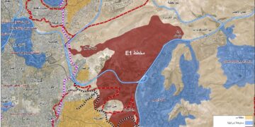
The term 'Bypass Roads' did not come into life until the signing of Oslo agreement between the Israelis and Palestinians in 1993 to indicate designated roads for the Israeli Army and settlers use, to bypass Palestinian towns and communities in the context of the Israeli Army redeployment. From that point on, Israel intensified its efforts to increase the magnitude of the bypass roads in the occupied Palestinian territory as a part of its policy to coerce facts on the ground; ultimately affecting the outcome of negotiation with the Palestinians; including the establishment of a viable contiguous Palestinian State. The Oslo accord classified the West Bank territory into three jurisdictions: Area 'A'; where the Palestinians have full control over the land; security and administrative wise, and Area 'B'; where Palestinians have only an administrative control, while security is for the Israeli, and Area 'C'; where Palestinians has complete control and the Palestinians has none. The majority of the West Bank area is Area 'C', which hold all Israeli settlements and consequently the Israeli bypass roads that pierce at many classified 'A' and 'B' areas establishing a physical obstruction between two controlled Palestinian areas.
Along with launching a vigorous settlements program following the Israeli occupation of the West Bank and Gaza, back in 1967, the consecutive governments of the state of Israel adopted a separation concept based on the creation of an Israeli controlled road grid system, which will work to facilitate the construction of Israeli settlements and the Israeli settlers movement between occupied territory settlements and Israel and eventually incorporate the Israeli created and controlled road grid system in the occupied territory with the road grid system in Israel. The Israelis built these roads under the pretext of 'security needs'; a term that presented the Israeli Army with legitimate excuse to expropriate Palestinian lands; a procedure that proved its efficiency before when the Israeli Army would expropriate Palestinian lands under the 'security needs' pretext to establish an Army base, which later on is turned to Israeli settlers control who would turn it on their part into a civilian inhabitant area. For Israel, that was the only available option or the only loop to bypass the international law, which considers, expropriating land for any purpose other than military use a 'grave breach'. Israel also argued the military role of the settlements and the bypass roads to its security, which allowed the Army to expropriate private Palestinian lands to build settlements and its roads; Israel also argued that the roads it is building will also benefit the local Palestinian population who would be allowed to travel on these roads. Furthermore, the Israeli built roads on confiscated Palestinian lands contributed immensely to stimulate the habitation of the Israeli settlements, which encouraged the Israeli settlers to take initiative and construct roads on their own, but would later on be endorsed and adopted by the Israeli Army to cast a shadow of legitimacy on these roads. In addition to its role in connecting settlements, the Israeli built roads worked to restrain the development of the Palestinian communities in the West Bank by creating de-facto obstructions to areas designated for development.
Prior to the outbreak of the September 2000 Intifada Palestinians had almost complete access to these bypass roads, except at time when the Israeli Army is on security alerts that Palestinians are no longer allowed to travel on the bypass roads or would have to undergo a through security check conducted by the Israeli Army border patrols, which would take hours at times. However, following the 2000 Intifada, Palestinians accesses to virtually all bypass roads became forbidden; unless they are in possession of a special permit issued by the Israeli civil administration. Later on, the Israeli Army would refer to bypass roads were Palestinian are no longer allowed to travel on as 'sterile' roads; meaning that these are Palestinians free roads.
Today, almost 800 Km falls under the bypass roads category are located in the West Bank, all constructed to comply with the Israeli settlements program and to facilitate movement of these settlements with each other and with Israel, beyond the Green Line. Palestinians are denied access to most of the bypass roads network and are blocked from them with cement blocks, trenches, earth-mounds, barbwires and iron gates; all under the pretext of military and/or security purposes. See Table 1
Table 1: Shows the number and the length of the Israeli bypass roads with the settlements, which the roads serve in the West Bank.
|
Governorate |
The total length of the Bypass Road |
No. of existing Bypass roads |
Settlements |
|
Hebron |
131.928 Km |
317, 356, 60, 35, 367, 3265, 325 |
Har Manoh, Adora, Eshkolot, Hagai, Telem, Tene (Maale Omarim), Karmei Zur, Negohot, Mirshalem, Otniel, Qiryat Arba', Ramat Mamre (Kharsine), Karmel, Maon, Susiya, Shima |
|
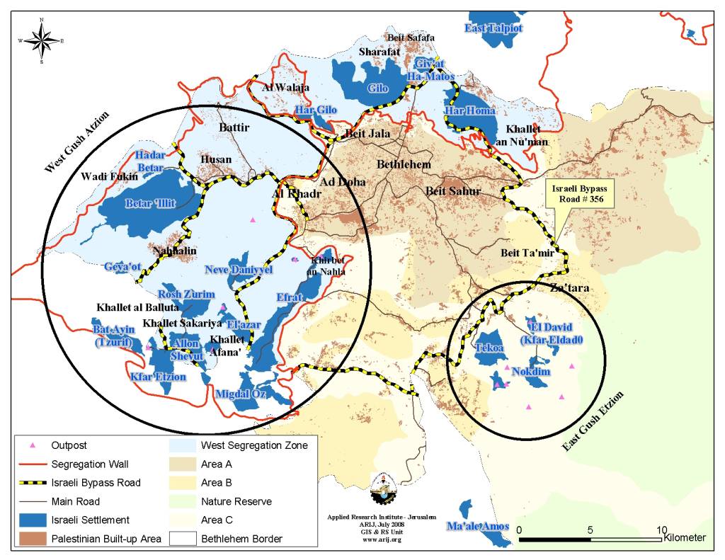
Bethlehem |
58.288 Km |
90, 60, 436, 375, 367 |
Mizpe Shalem B, Gilo, Kfar Etzion, Avenat, Har Gilo, Betar Illit, Efrat, Elazar, Allon Shevut, Neve Daniyyel, 'Ayn Fashkhah, South Avenat, Mizpe Shalem |
|
Tubas |
44.583 Km |
90, 578 |
Beqaot, Shadmot Mehola, Mehola, Bitronot (Shila), Roi |
|
Jerusalem |
78.942 Km |
90, 1, 458, 60, 457, 45, 436, 443 |
Sha'ar Benyamin, Allon, Atarot, East Talpiyot, Givat Shappira, Neve Shamual, Neve Yaacov, Pisgat Zeev, Ramat Eshkol, Givon, Mishr Adummim (Industrial Center), Maale Adummim, Neve Brat, Pisgat Amir, Rekhes Shuafat, Ramot, Kokhav Yaacov, South Allon, Givat Zeev |
|
Jericho |
89.701 Km |
1, 578, 508, 57, 90, 505 |
Argaman B, Atraqzia, En Hogla (Moul Nevoh), North Dead Sea (Solar Pond), Massua, Maale Efrayim, Yafit, Tomer, Gilgal, Niran, Noomi (Na'ama), Lido Yehuda, Pezael (Fezael), Hamra, Mizpe Yeriho |
|
Jenin |
14.194 Km |
NA |
Kaddim |
|
Tulkarem |
15.279 Km |
557 |
Enav, Avnei Hefetz |
|
Nablus |
94.986 Km |
557, 508, 505, 458, 60, 57 |
Matkhan Tappuah, Migdalim, Eli, Homesh, Israeli Quary, Shavei Shomron, Elon Moreh, Itamar (including Itamar1,2,3,4), Gittit, Mekhora |
|
Salfit |
54.914 Km |
60, 505, 4775, 5506, 55, 446, 5 |
Benot Orot Yisra'el, Elkana, Har Alei Zahav, Industrial Zone (Near Peduel), Peduel, Revava, Kfar Tapuah, Rachelim (Shvut Rahel), Arial, Barqan industrial Znoe, Yakir, West (Arial West Park Industrial) |
|
Qalqiliya |
28.993 Km |
55, 505, 5506, 60 |
Shaare Tikva, Ginnot Shomeron (part of it in Salfit governorate), Kedumim, Karne Shomron, Jit, Immanuel |
|
Ramallah |
182.982 Km |
458, 436, 443, 446, 465, 463, 466, 60, 457, 449 |
Lapid, Beit Arye, Dolev, Hashmonaim, Kfar Rut, Mattityahu, Menora, Nili, Ofarim, Shilta, Makkabim, Beit Horon B, Nahliel, North Sha'ar Benyamin, Maale Mikhmas, Beit Horon, Modin Illit (Qiryat Sefer), Naaleh, Hallamish, Ateret, Talmon C, Talmon B, Talmon, Shilo, Beit El (A + B), Ofra, Pesagot, Kokhav haShahar, South Ofra |
Source: ARIJ -GIS database, 2007
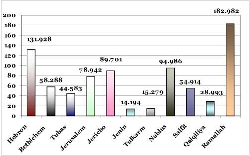
The old- new Israeli vision to control over the West Bank by constructing the current transportation System of the bypass roads comes along with the construction of the Segregation Wall, which will isolate more than 40% of the West Bank in order to provide security for the 500,000+ Israeli settlers in the West Bank including East Jerusalem. In addition, most of the Palestinian drivers accessing Israeli roads are systematically abused by the Israeli Occupying Forces and had been subject to the Israeli humiliation, beatings, damaging their cars and sometimes confiscating their licenses. Chart 1 & 2 below show the total length of the Israeli bypass roads in the West Bank and the total number of the bypass roads in each Palestinian Governorate.
Chart 1: Shows the total length of the Israeli bypass roads in the West Bank
Source: ARIJ -GIS database, 2007
Chart 2: Shows the total number of bypass roads in each Palestinian Governorate

Source: ARIJ -GIS database, 2007
Prepared by
The Applied Research Institute – Jerusalem