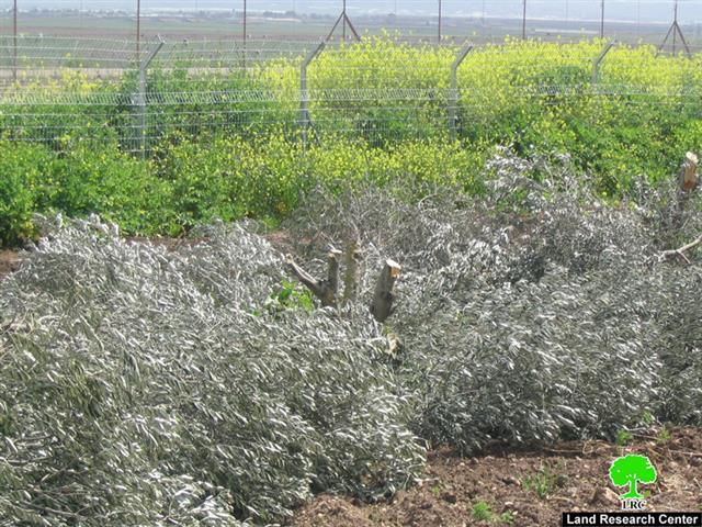
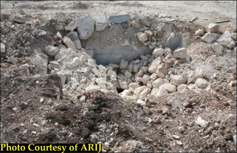
On January 15, 2008, and without a prior notification, the Israeli bulldozers along with the Israeli Occupation Forces raided Wadi Al-Qalamoun and Umm-Al Khanazir lands on the western edges of Beit Ulla village northwest of the city of Hebron, and started destroying and leveling some 90 Dunums of and, uprooting thousands of trees and destroying water wells and cement walls. The reported damages were as follows:
|
Owner |
ID No. |
Land's Area |
Cement Wall's Length |
Fence's Length |
No. Wells |
No. Uprooted Trees |
|
Suleiman Mahmud Al 'Adam |
955770631 |
10 |
750 |
600 |
1 |
400 |
|
Mahmud Khaled Al 'Adam |
994701837 |
10 |
750 |
600 |
1 |
400 |
|
Mahmud Abdel Hafez Al 'Adam |
987156155 |
10 |
500 |
*** |
1 |
400 |
|
Hassan Abdel Hafez Al 'Aadam |
914086061 |
10 |
500 |
*** |
1 |
600 |
|
Sami Isma'eel Al 'Adam |
994406759 |
10 |
750 |
600 |
1 |
600 |
|
Musa Isma'eel Al 'Adam |
994702702 |
10 |
750 |
600 |
1 |
400 |
|
Muhammad Salim Al 'Adam |
977246354 |
10 |
500 |
600 |
1 |
400 |
|
Ahmad Abed Rabbu Abu Habtin |
938367612 |
10 |
500 |
600 |
1 |
400 |
|
Issa Isma'el Al 'Adam |
902599844 |
5 |
250 |
250 |
0 |
150 |
|
Abdel Hafeez Al Atrash |
NA |
5 |
0 |
250 |
0 |
150 |
|
TOTAL |
*** |
90 |
5250 |
4100 |
8 |
3900 |
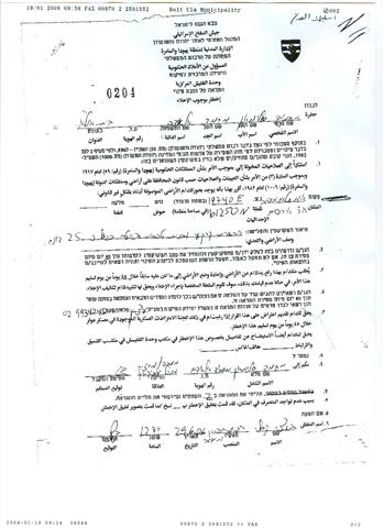
In an interview with ARIJ's field workers the owners of the 45 dunums of lands located in Wadi Al-Qalamoun area indicated that they had received two military notifications in June 29, 2006 (see copy of military orders 1 & 2) holding Numbers (204, 210). holding Numbers (204, 210).
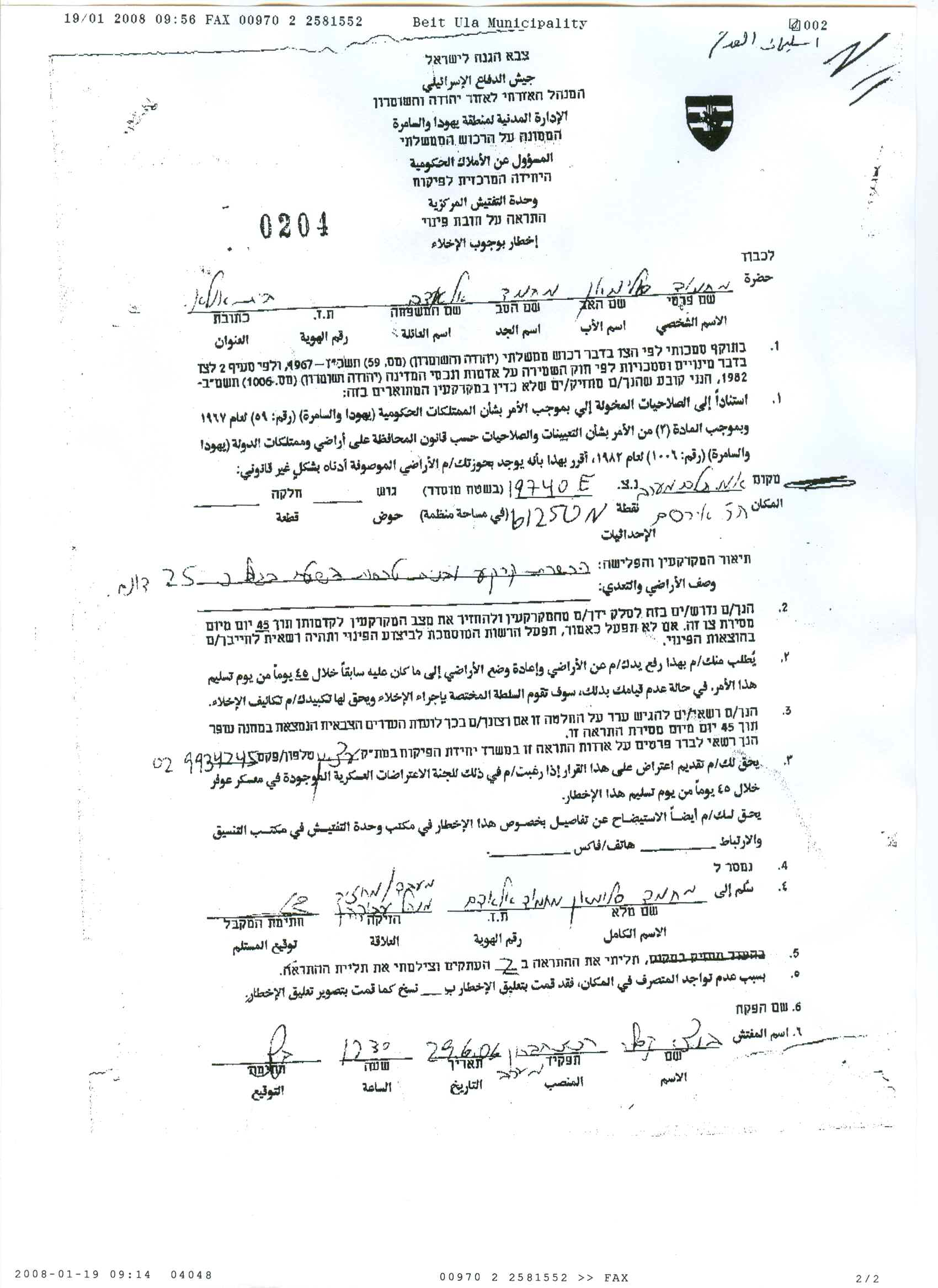
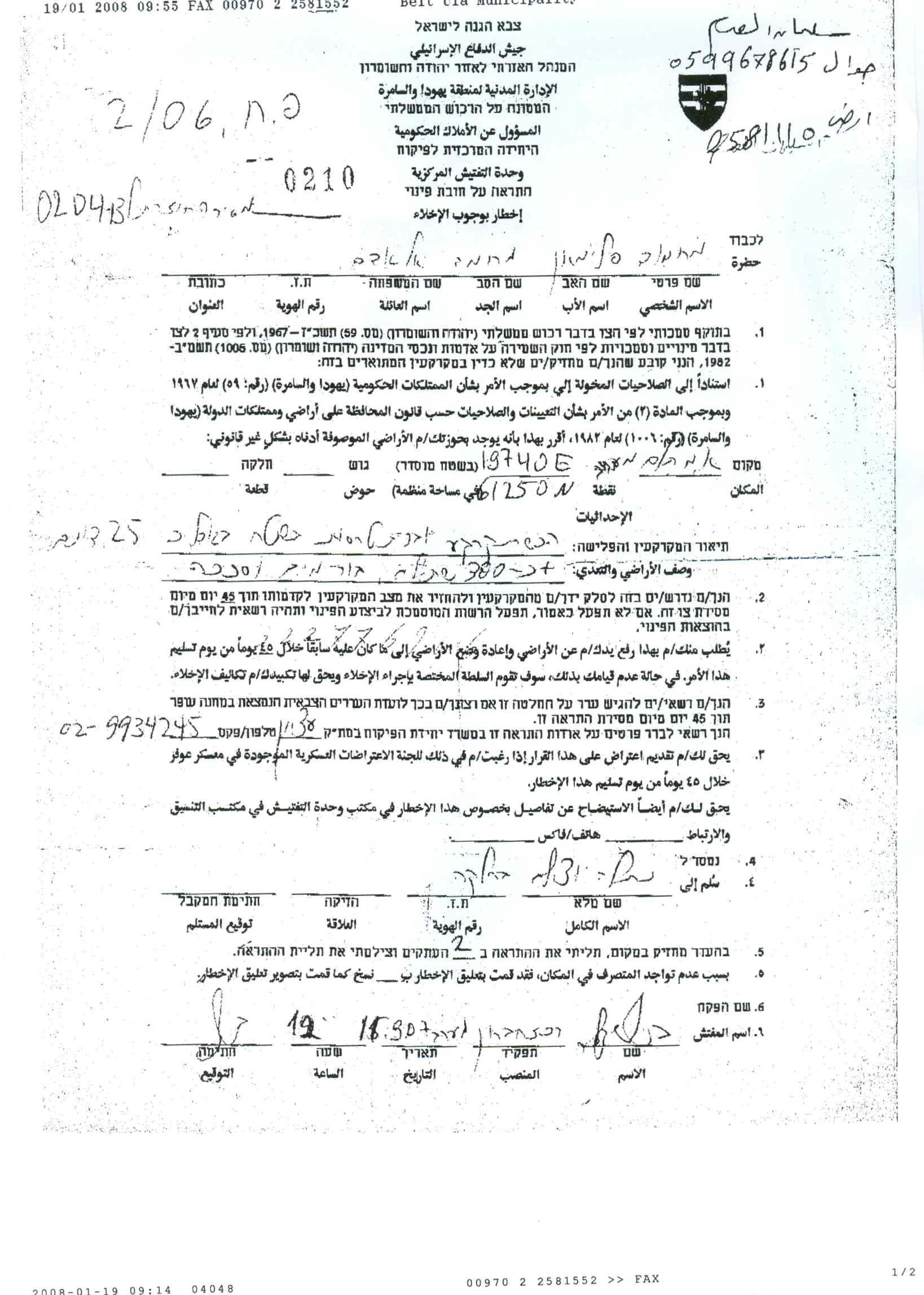
The orders were issued by the Israeli Custodian of Absentee Land Property in the Israeli Army, with a warning for the landowners to remove all what exists on the targeted land, which includes trees, infrastructure installations, and anything else; under the pretext that the land is classified as 'State Land'. It should be indicated that the targeted land is located some 300 meters east of the 1949 Armistice Line (the Green Line).
On the other hand, the owners of the other 45 dunums located in Umm Al-Khanazir stated that they had never received any Israeli warning or military order from any Israeli authority with this regard. It should be noted here that the targeted land is located some 1.4 km east of the Israeli Apartheid Segregation Wall route running parallel west of the village. The owners of the lands in question have cultivated it before the 1967 Israeli occupation of the West Bank territory and they continued to do so until January 15, 2008. See map 1.
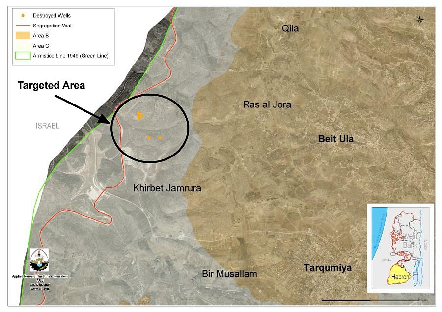
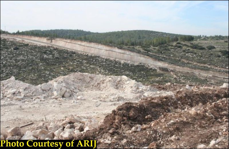
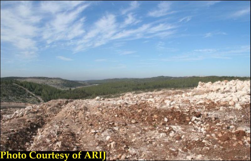
It is worth mentioning that the 90 dunums targeted by the Israeli bulldozers were part of land reclamation project funded by European Commission with a total cost of $200,000. See Attached pictures


The Palestinian Village of Beit Ulla is located 10 kilometers northwest of the city of Hebron, bordered by Nuba and Kharas villages from the north, Middin, and Tarqumia villages from the south, Ras Al-Jura village from the west and the village of Halhul from the east. The village spread on 22,432 dunums and home to 9859 residents (PCBS 2006). According to Oslo II Interim Agreement of 1995 between Israel and the Palestinian Liberation Organization (PLO); Beit Ulla was classified as follows:
|
Beit Ulla�s Land Classification according to Oslo Agreement of 1995 |
||
|
Land Classification |
Area- Dunums |
% from the village�s Area |
|
Area A |
0 |
0 |
|
Area B |
16,692 |
74.5 |
|
Area C |
5,740 |
25.5 |
|
Total Area |
22,432 |
100 |
|
Source : ARIJ Data Base |
||
Source: ARIJ GIS Database 2008
Acquisition by Declaring 'State Land'
When Israel occupied the West Bank in 1967, only one third of the land was registered to the people while the remaining two thirds of land ownership was proven by a Turkish issued Tabo (certificate of ownership) and an official British certificate/ registration. Purchase and/ or registrations of land made under Jordanian law prior to 1967 are also valid deed of land ownership. Fundamentally, the Ottoman land code (law) continue to govern the land holdings in the West Bank even with amendments passed during the Jordanian rule and the Israeli military orders issued since the 1967 occupation.
The objection committee is the only authority entitle to question the declaration of lands classified as 'State Lands' and since it is controlled and administered by the Israeli military it had been impossible to alter any declaration which is made in the first place by the same source. The Israeli high court has also distant itself from the issue after its infamous ruling on the Elon Moreh case that constituted an official outbreak of the settlement program in 1979 by declaring that it will not intervene in any lands disputes unless the land in subject of seizure is privately owned.
The Israeli military has arranged to acquire Palestinian lands for the Israeli settlements and controlled all procedures to cast off the objection appeals made by the Palestinian residents against any acquisition order, which paved the way for the Israeli Army to acquire hundreds of thousands of Dunums of Palestinian lands following the 1967 occupation.
The acquisition declaration come in a form of Israeli Ministerial decision to build a new settlement or expand existing one or to construct a bypass road that serve the interest of the Israeli settlers. The Israeli Ministry of Justice then reviews the decision for the declaration before it passes to Israel Land Authority (ILA) and to the Office of the Custodian of Absentee and State Lands for further review. Afterward the decision is mete out to the residents who wishes to appeal the declaration decision before the military Objection Committee.
The objection committee requires that each landowner submit a survey map of the targeted area, which usually exceeds 2000 Dunums, a sworn statement of ownership and all relative documents to prove an ownership, all within 30 days of the declaration. However, the objection committee will not acknowledge receipts for payment of tax on the land or registration in the tax department as permissible attestation of ownership. Land cultivation for 10 consecutive years (Ottoman Land Code) prior to the declaration is the basis of ownership the objection committee requires the appellant to submit as a proof of ownership. In most of the cases, the custodian has available proof (aerial photos provided by the military) that the targeted lands have not been periodically cultivated. On the other hand, the Israeli Authorities have always denied the Palestinian farmers the right to drill artesian wells that made them (the farmers) more dependent on the uncertain rain-fed cultivation.
Acquisition by Declaring 'Closed Military Zones'
The Israeli Military occupation has issued many unnumbered military orders declaring certain areas of the West Bank as 'closed military zones' under which Palestinian's movement and that of unwelcome visitors (reporters) into these certain areas is restricted. The Israeli military occupation often attributed the closed areas are used as a training ground for the Army, including firing ranges. However, considerable parts of these areas would turn later on to the Israeli settlers' benefits such as the case of Kiryat Arba settlement (established 1972) in the heart of Palestinian city Hebron, and now for the benefit of constructing the Israeli Segregation Wall.
::::::::::::
* Palestinian Central Bureau of Statistics
Prepared by
The Applied Reserach Institute – Jerusalem