It became evident that the under construction Israeli Segregation Wall is an interpretation of the long dragged Israeli policy of land grab, oppression and injustice practiced against Palestinians in the occupied territory and their rights as individuals and as a inhabitants. Since Israel started its unilateral apartheid project in the West Bank and East Jerusalem back in 2002, it pretext was to provide security for the people of Israel, but soon enough as things progressed, Israel revealed its hidden agenda, which is to grab of the Palestinians’ land as much as it possibly can, before a settlement with the Palestinians is either reached or imposed (figuratively) upon them at a later stage.
During the years to follow, the route of the Segregation Wall has taken different courses in the occupied territory, but none of the changes made was significant enough to convince the Palestinians or the world for that matter, that the Segregation Wall relates to security at any time. In this manner, the Israelis grew apathy to mask their actions as some Israeli official declared repeatedly the Segregation Wall might very much constitute the western border of the Israeli State. To this end, Israel made sure at every revised plan of the Segregation Wall route to include the major settlements blocs where more than 80% of the Israeli settlers live to in the area isolated behind the Wall.
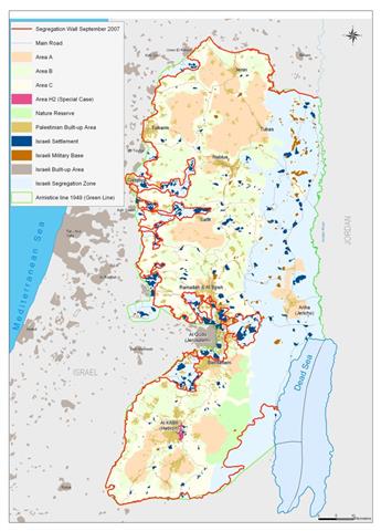
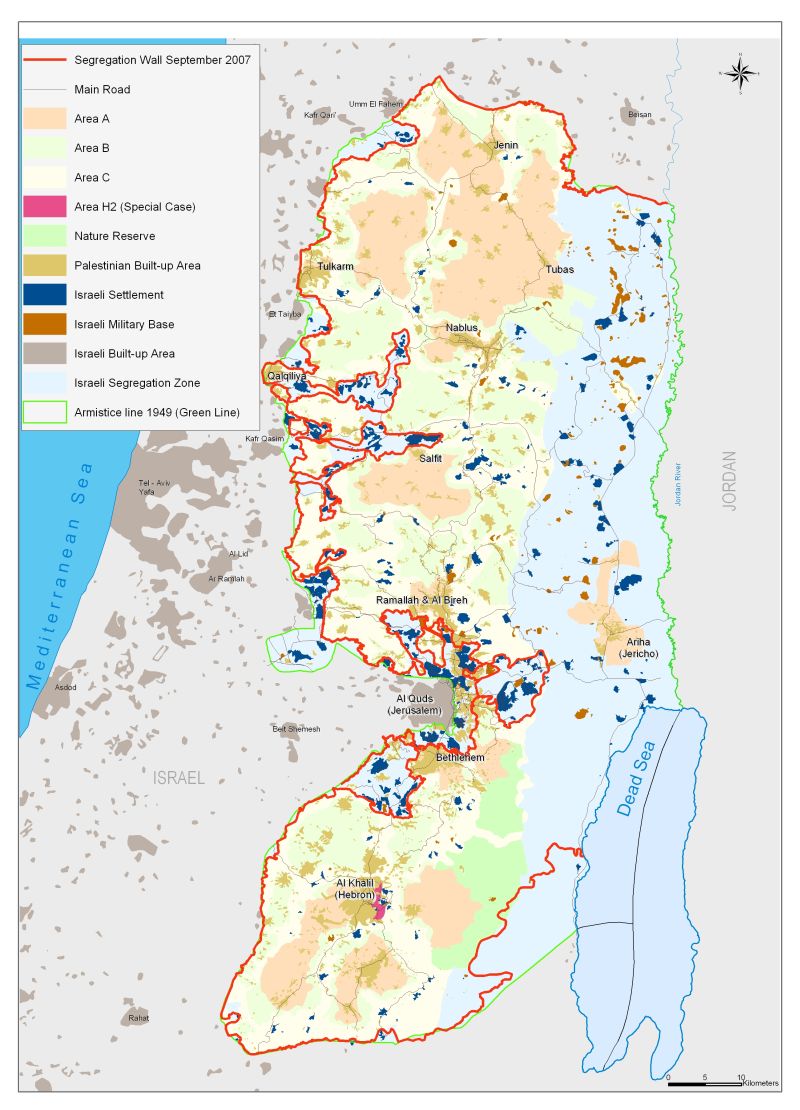
In September 2007, the Israeli Army revealed the latest route designated for the Segregation Wall in the occupied Palestinian territory; even though the endorsed map shows that, the plan was out by April 30, 2007. The new route; as analyzed by the Geo-Informatics Department at the Applied Research Institute (ARIJ) runs 770 Km across the occupied Palestinian territory, an increase by 9.5% (67 Km) to the route of April 30, 2006 (703 Km). it will also isolate an additional 158 Km2, bringing the total number of land isolated to 713 Km2 (12.6%) of the occupied Palestinian territory. According to the new route of the Wall, 107 Israeli settlement with a population exceeding 80% of the settlers’ population are included behind the Wall, which makes it easy enough to conclude that the settlements and the settlers had an influential role to changing the route Segregation Wall on various stages. Table one below shows the status of the Segregation Wall as of September 2007.
Table 1: Status of the Segregation Wall as of September 2007
|
Status of the Segregation Wall Km |
Percentage of the total Wall length |
|
|
Existing sections |
397 |
51.6% |
|
Planned sections |
70 |
9.1% |
|
Under construction |
303 |
39.3% |
|
Total |
770 |
100% |
Source: ARIJ Database 2007
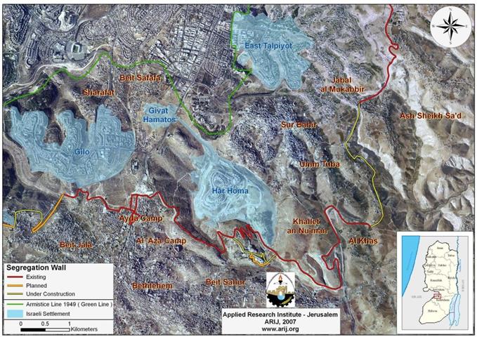
One of the two new additions in the Wall length where in the northwestern part of Ramallah where an additional part section of the Wall of 13.5 Km was injected to the route to include the two Israeli settlements Nili and Naaleh. This new addition was a result of pressure exerted by settlers’ leaders in the occupied territory on the Israeli government to include these two settlements. The other addition took place in the southeastern part of Hebron through an additional 53.5 Km length section of the Wall. (See map 1).).
A new unprecedented development with regard to the route of the Segregation Wall, as it touches the Dead Sea shores for the first time to mark part of it isolated by the Wall. Already, the Israeli Army has denied Palestinians access to the Dead Sea area as of the beginning of this year, using “security” as a pretext.
Detrimental consequences of the Israeli Segregation Wal
According to the route set by the Israeli Army for the Segregation in 2007, the land area isolated is vastly agricultural and uninhabited. However, 29 Palestinian villages’ boundaries with a total area of 216.7 Km2 of will become trapped in enclaves. In addition to that, 138 Palestinian villages’ boundaries are largely effected, some 554.4 Km2 will be lost behind the Segregation Wall, where the owners will need to obtain special permits issued from the Israeli Army to access their land, providing that they come up with the necessary documents requested by them, and even in the event, such permits are produced, it will be seasonally based, meaning that the land owners will receive the permits based on whatever crops the land is cultivated with, just at the harvest season.
Tables 2 & 3 below Map 2 shows the villages isolated and affected by the construction of the Segregation Wall.
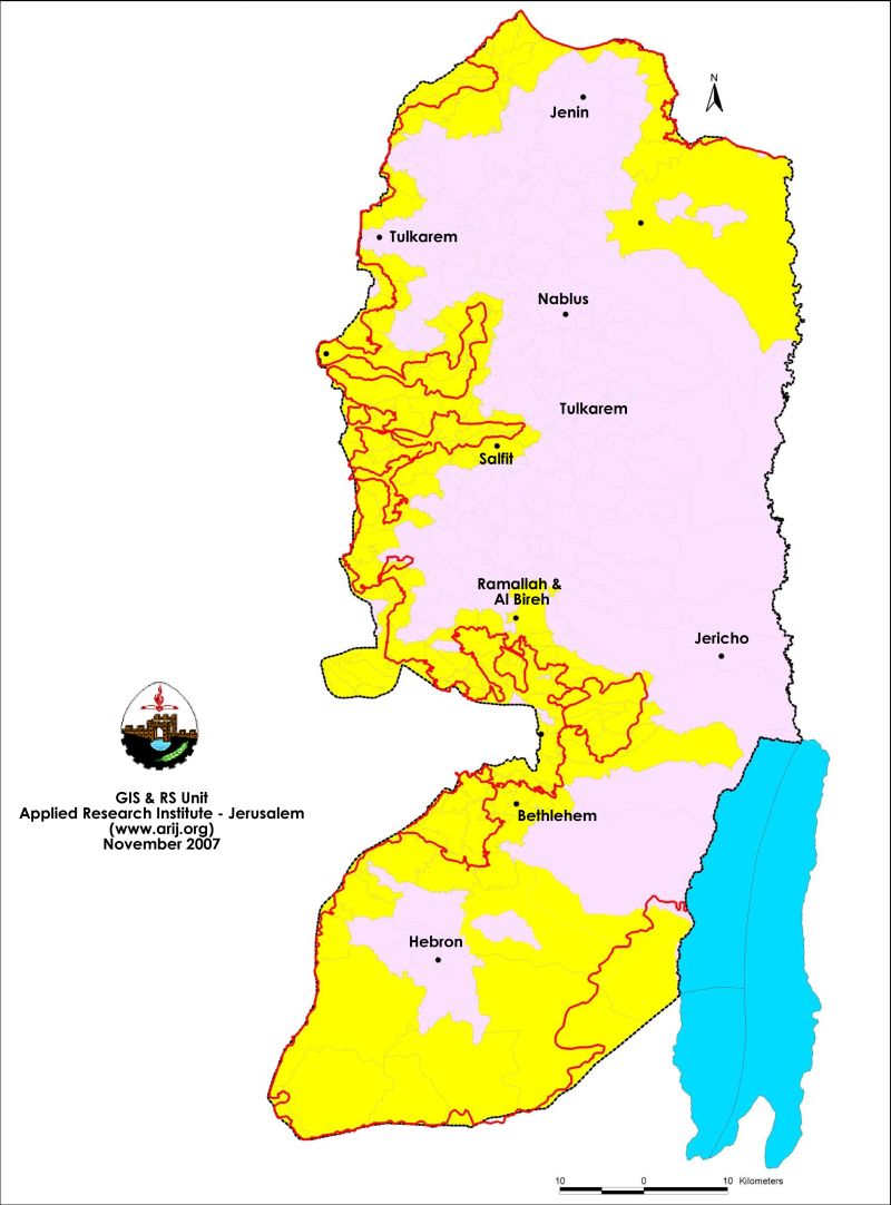
Table 2: Palestinian villages isolated by the Wall
| Number ofPalestinian villages’ boundaries Enclaved by the SegregationWall | ||
| Governorate | # ofvillages Enclaved | IsolatedArea- Dunums |
| Hebron | 1 | 1,673 |
| Jerusalem | 10 | 94,492 |
| Bethlehem | 5 | 37,073 |
| Ramallah | 9 | 44,443 |
| Salfit | 4 | 38,886 |
| TOTAL | 29 | 216,567 |
Source: ARIJ Database 2007
Table 3: Number of Palestinian villages affected by the Segregation Wall in each Governorate
| Number ofPalestinian villages’ boundaries affected by the SegregationWall | ||
| Governorate | No. ofAffected Villages | IsolatedArea(dunums) |
| Hebron | 13 | 32,009 |
| Jerusalem | 28 | 156,878 |
| Bethlehem | 9 | 63,527 |
| Jenin | 19 | 33,266 |
| Qalqiliya | 16 | 65,127 |
| Ramallah | 23 | 85,519 |
| Salfit | 17 | 99,746 |
| Tubas | 2 | 2,139 |
| Tulkarem | 11 | 16,159 |
| TOTAL | 138 | 554370 |
Source: ARIJ Database 2007
The applied research Institute-Jerusalem (ARIJ) is deeply concerned to the series of escalations carried out by Israel against the Palestinian people, their lands and properties, and to the increasing series of land confiscation and manipulation of the Segregation Wall route to conform their land grabbing agenda. All of this happens at the time that Israel’s indifference to the international law, and the UNSC resolutions has increased more than ever before, especially know with more than three years has past by to the International Court of Justice ruling on the Segregation Wall and the Israeli settlement. Instead, Israel altered the route of the Wall twice, increased settlements' construction, and increased number of various obstacles (checkpoints, earth mounds, roadblocks, etc) and continues with its systematic violations of Palestinians’ right to live adequately, without the constant threats to their well-being.
The Israeli government justifies the construction of the Segregation Wall in the occupied West Bank territory as a key 'security' element to the Israeli settlers, but the constant changes to the route of the Wall shows that it is much more, and that it deals with land grab, to consolidate Israel’s control over vast agricultural Palestinian lands and the main Israeli settlements’ blocs built there in order to annex it to Israel later on. However, Israel apathy to the international and humanitarian laws made it easier for them to consider the consequences of their actions carried out in the occupied Palestinian territory, cutting out many Palestinian communities from their natural environment and place them in ghettos, isolated from their lands and from neighboring communities.
Prepared by
The Applied Reserach Institute – Jerusalem