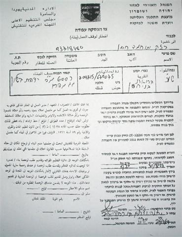
On October 27th, 2007, the Israeli occupation authorities sent halt-construction warnings to the owners of four houses and two stores in the village of Haris, Salfit governorate, under the pretexts of un-licensing and for being close to bypass road number 505 connecting between Ariel colony and 1949 Armistice Line (Green Line). The following table provides data about the threatened premises:
|
No. |
Owner's name |
Owner's age |
Information about the threatened premises |
|
1 |
Abdullah Mohammed Daood |
49 |
Commercial store |
|
2 |
Hasan Khalid Shaja'ieh |
23 |
Commercial store |
|
3 |
Mustafa Hussein Taysir |
68 |
A two storey completed house |
|
4 |
Hussein Hamid Daood |
46 |
A one storey completed house |
|
5 |
Abdullah Musa Abu Baker |
66 |
A two storey uncompleted house |
|
6 |
Adnan Fawzi Abu Baker |
35 |
A two storey uncompleted house |
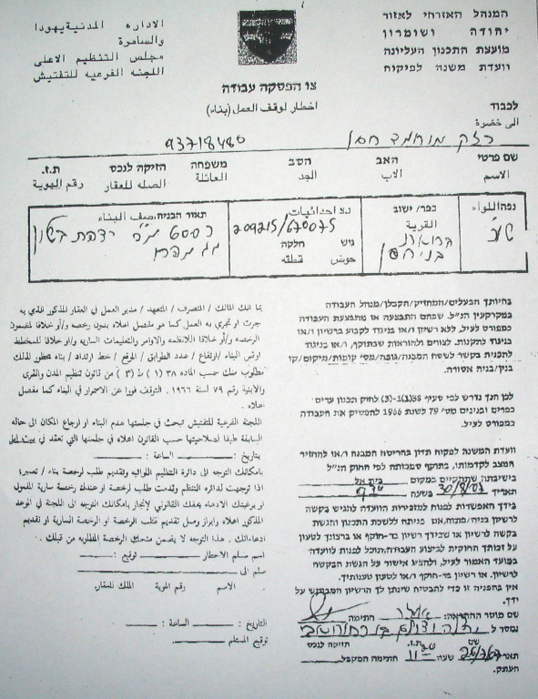
(Photo 1: a copy of one of the halt-construction warnings)
Legal action
The owners of the threatened structures, in cooperation with the village local council, presented an objection to the Israeli planning committee at Beit Eil 'civil administration' near Ramallah against the warnings. Also, they are planning to send another objection to the Israeli supreme court.
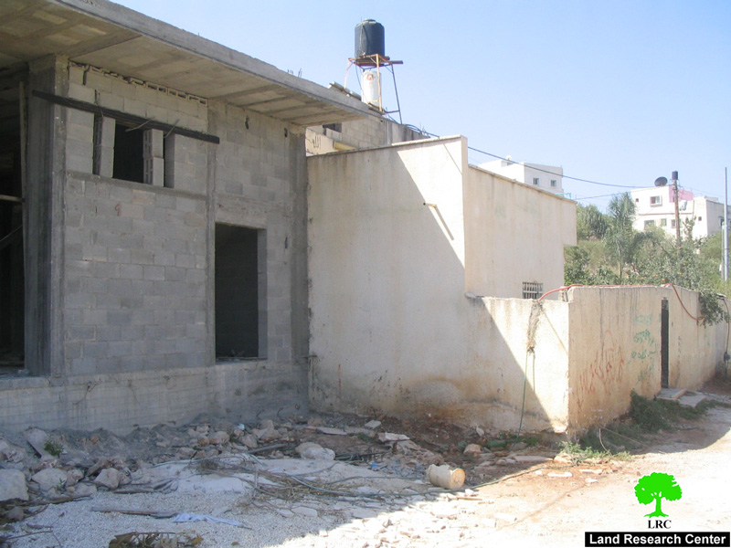
(Photo 2: one of the under construction threatened houses in Haris village)
Apart from the latest warnings 8 others have been issued since the year 2000 under the pretext of building in zone C of Oslo agreement's classifications under total Israeli civic and military supervision .
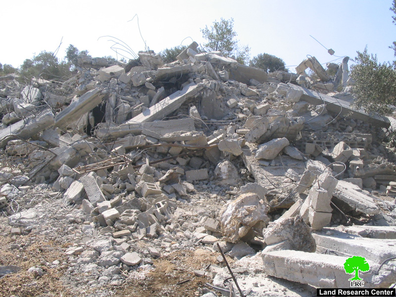
(Photo 3: a previously demolished house in Haris village)
Introduction to Haris village
Located 7 km to the west of Salfit city. It has a total surface land area of 8450 dunums (one dunum equals 1000 m2) of which only 319 dunums designed by the Israeli occupation authorities as built up area. The Palestinian Central Bureau of Statistics' population projection shows that the village of Haris will have a total of 3458 people by the end of this year. See Map 1
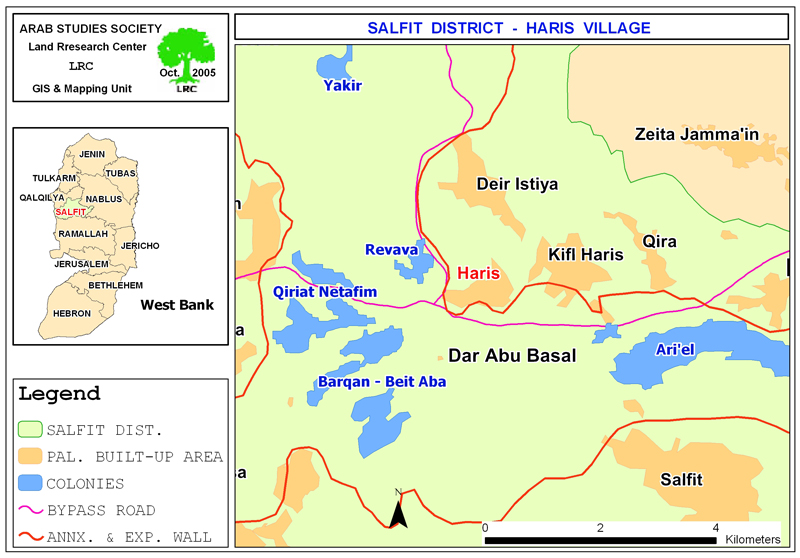
The village has lost almost half of its land – 4000 dunums – for the establishment of the bypass road number 505, Segregation Wall and the following four colonies:
|
Colony name |
Date of establishment |
Municipal area |
Built up area |
Population 2005 |
|
Barkan |
1981 |
2720 |
349 |
1231 |
|
Kiryat Netafim |
1982 |
1540 |
162 |
438 |
|
Revava |
1991 |
1540 |
160 |
827 |
|
Ariel |
1978 |
13775 |
2479 |
16520 |
|
Total |
19575 |
3150 |
19016 |
|
Source: – GIS unit at LRC.
– Foundation for Middle East Peace- Washington.
Zone C: deducted at the expense of Palestinian planning schemes
The Israeli occupation authorities preceded the Olso agreement in 1993 with the announcement of planning schemes for all the Palestinian cities, towns and villages in the West Bank in which it unilaterally drew up the borders of the built up areas for each Palestinian residential area based upon Israeli needs and greed. That is, all the Israeli – announced Palestinian built up schemes were limited to certain areas under the names of zone A and B and the remaining lands were announced C which remained under total Israeli civic and security affairs. The reason behind this policy was to name as much land as possible under zone C before going into talks with the Palestinian side.
As a direct effect of this policy many villages and towns has lost most of their land to zone C where Palestinians are not allowed to get any construction permissions on this land. The village of Haris is a typical example. All of the threatened structures are located in zone C outside the borders of the Israeli imposed built up area whose total area is 319 dunums. This situation has put the owners and inhabitants of these houses in constant fear as Mr. Mustafa Hussein Taysir, one of the owners, had said to LRC field worker: 'Me and my family have been living in a continuous nightmare since we received the notification form last month. This feeling of insecurity is very bad for all of us. I was forced to build here because I have no other land to build on'.
Settler's violence
In related development, Israeli settlers from Qiriyat Netafim colony prevented Palestinian farmers from Haris and other neighboring villages from picking olives during the latest harvesting season in the month of October under the pretext that the land is located in the security belt of the colony. The settlers used their machine guns to open fire in the air to dismiss olive pickers out of their fields. This act of terrorism on the part of settlers had deprived about 60 families from their only source of living, thus, increasing the level of unemployment and poverty in the Palestinian villages in that particular area.
Prepared by
The Land Research Center – Jerusalem
LRC


