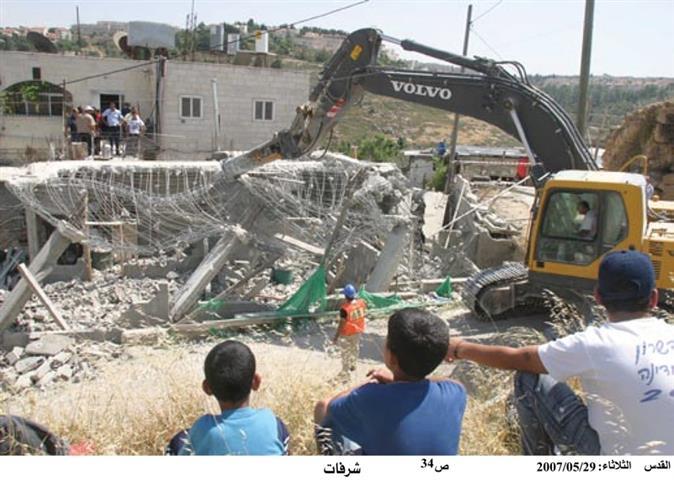
On July 30, 2007, the Israeli Army gave out six demolition notices to residents of Qarawat Bani Hassan village to halt construction works on their houses under the pretext of being built without permits from the Israeli Civil administration. The houses are located in area 'C ', and are owned by: Mohammad Hassan 'Abdy, Ali Hassan 'Abdy, Thyab Mashhour 'Asy, Amine Yassin Mar'i, Ayman Yassin Mar'i and Ahmad Ibrahim 'Asy. See copy of military warning
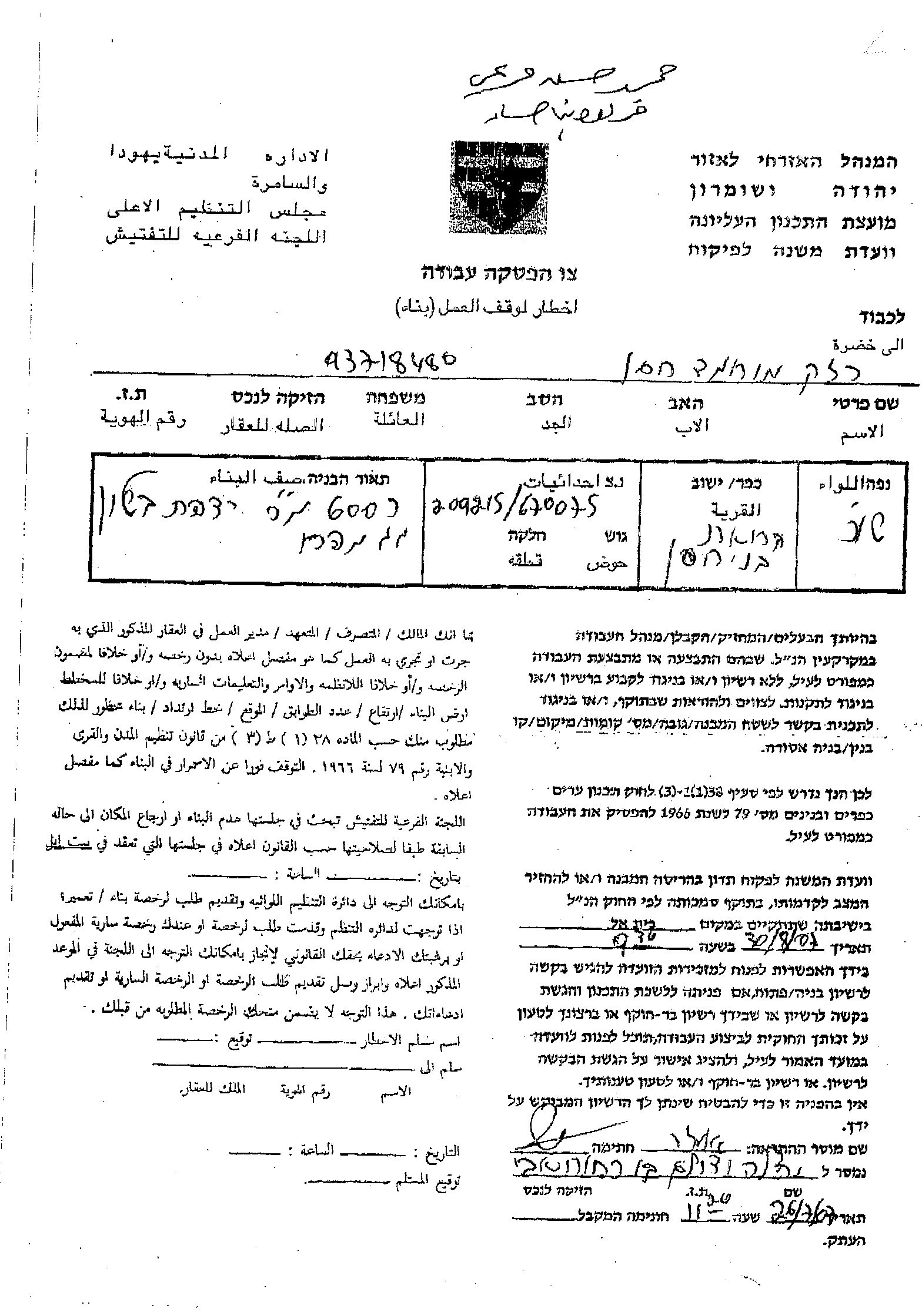
As stated in the military notices, owners of the threatened houses were given a grace period until August 30, 2007 to start processing licenses to the houses before a final decision by the regional committee of housing and construction is made to whether to demolish the houses or spare them at their status upon the progress of licenses procedures.
This is not the first time that Palestinians from Qarawat Bani Hassan village received demolition notices. During the last few years, (2004-2005), a total of 22 house demolition notices were handed out to residents of the village claming that the threatened houses were built without proper licensing.
Building licenses in Qarawet Bani Hassan village (like the rest of West Bank villages), were obtained from the Israeli 'Civil Administration', from 1967 until Oslo Agreement in 1995. After 1995 and the Classification of the West Bank land into A, B, C areas.
-
Area A: are the Lands that falls under the complete Palestinian control,
-
Area B: are the lands were the Palestinian Authority has full control over the civil administration and Israel continues to have overriding responsibility for security;
-
Area C: are the areas where the Palestinian authority has responsibility for civil life such as health and education while Israel retains full control over security and administration related to territory, including land.
This means that lands located within areas classified 'C' must continue to get the building license from the Israeli 'Civil Administration' where the Israeli Civil Adminsitration rejects their permits most often.
Location & Population
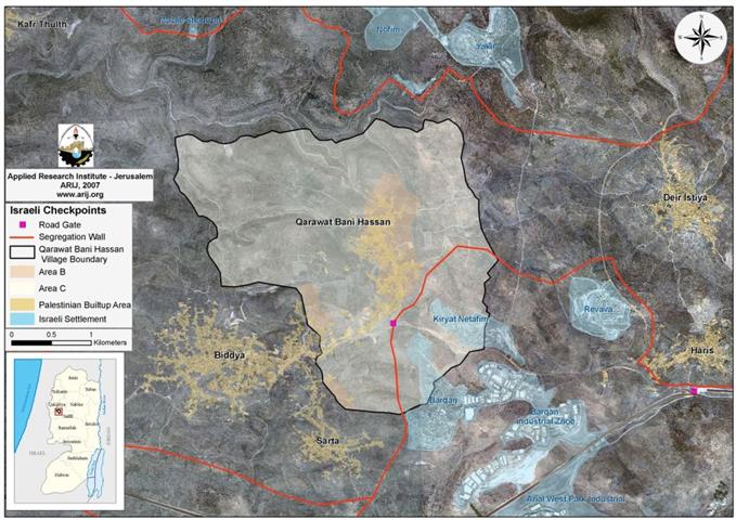
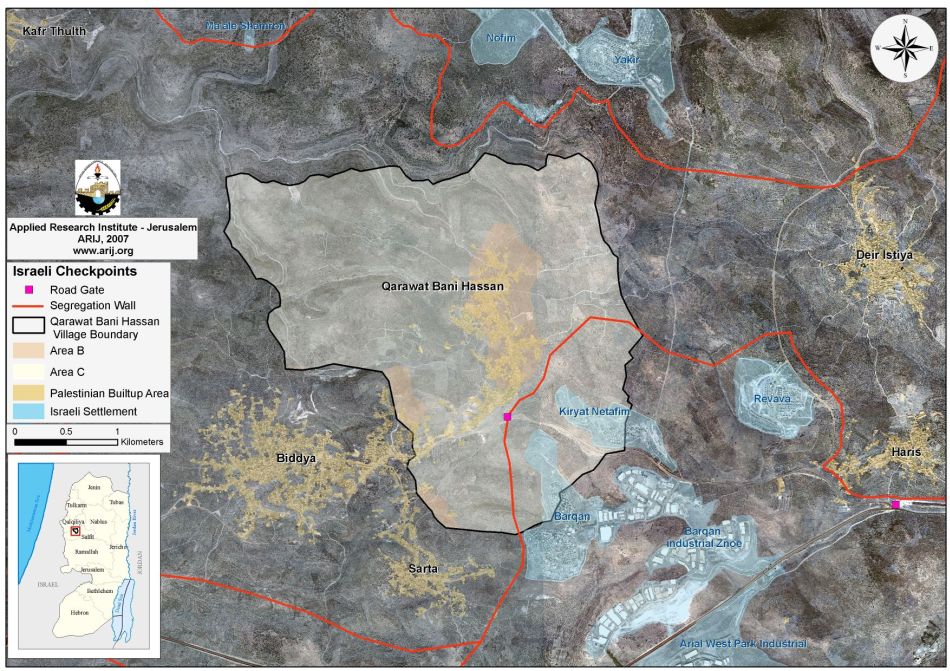
Qarawat Bani Hassan village is located to the northwest of Salfit city. It occupies a total area of 9684 dunums, out of which, 507 dunums of which are the built- up area of the village. It is bordered by Revava and Kiryat Netafim settlements from the south, Deir Istyia and Haris villages from the east, Bidya village from the west and the settlements of Yakir and Nofim from the north. The village is a home to 3713 residents according to the Palestinian Central Bureau of Statistics – population projection 2006.
According to the Oslo II Interim Agreement signed in September 1995 between the Palestinian Liberation Organization (PLO) and Israel, 1040 dunums (10.7 % of the village's total area) were classified as Area B (Areas under Palestinian civil administration but Israel continues to have an overriding control on security) while the remaining 8644 dunums (89.2% of the village's total area) were classified as Area C (Areas under full Israeli Control).
Previous house demolitions actions
On November 23, 2006, the Israeli bulldozers stormed the village and demolished two Palestinian structures without warning. The demolished homes belonged to Nabel Yassin Khalil Mar'i (Barrack – 500 m²) and Mohammad Mustafa Abu Daya (House – 321.5 m2) under the same pretext.
On June 27, 2007, the Israeli Occupation Army handed resident Mohammad Salem Mohammad Mar'i military order to halt constructions of his two –storey house (150 m2).
Israeli Settlements in Qarawat Bani Hassan:
The village of Qarawat Bani Hassan is one among many Palestinian villages whose residents’ lands were coarsely confiscated for Israeli colonial activities which commenced following Israel's occupation of the West Bank and the Gaza Strip in 1967.
An Analysis conducted by the Applied Research Institute – Jerusalem (ARIJ) showed that two Israeli settlements are located within the village boundary of Qarawet Bani Hassan village and have caused the loss of 419 dunums (4.3 %) of the village's total area. The two settlements are:
1. Barqan: located to the south of the village and was established in 1981. The settlement sets on an area of 649 dunums of land, out of which, 215 dunums were confiscated from Qarawet Bani Hassan village. Today, the settlement is a home to 1300 Israeli settlers.
2. Kiryat Netafim: located to the southeast of the village and was established in 1982. Today, the settlement occupy an area of 386 dunums of Palestinian lands, out of which, 204 dunums were confiscated from the village of Qarawet Bani Hassan. Today, 440 Israeli settlers live there. See Map 1.
The Segregation Wall and Qarawet Bani Hassan village
Qarawat Bani Hassan village is also facing the threat of the Israeli Segregation Wall. According to the Israeli revised wall map of April 30, 2006, the village will lose some 1598 dunums (16.5 %) of its lands for the construction of the Segregation Wall, which will extend a length of 3 kilometers, and will isolate the far southeastern part of the village. See Table 1 & Map 1.
|
Land Use Land Cover of Qarawet Bani Hassan Village – Salfit Governorate |
|||
|
Land Use Land Cover |
Total Land Area |
Lands slated for Isolation by the Israeli Segregation Wall |
% of Total village area |
|
Agricultural Lands |
6178 |
713 |
7.4 |
|
Forests & Open Spaces |
2479 |
466 |
4.8 |
|
Artificial Surfaces |
17 |
0 |
|
|
Palestinian builtup area |
591 |
0 |
|
|
Israeli Settlement |
419 |
419 |
4.3 |
|
|
|
|
|
|
Total Area |
9684 |
1598 |
16.5 |
Source: ARIJ GIS Database 2007
As shown in Table 2 above, the village will lose much of its open spaces and agricultural lands behind the Israeli segregation wall. It is worth pointing out that the Israeli Segregation Wall will end up encompassing two illegal Israeli settlements behind its path.
Entrance to the isolated agricultural lands will only be restricted to farmers who are able to prove land ownership through a credited Israeli organization (most likely to be the civil administration) and only the owners whose names listed in the ownership deeds (usually the eldest of the families) will receive permits. In addition, the Israeli civil administration will only issue permits on seasonal basis. Hence the owners will find a hard time to manage the cultivated lands on their own especially that the permits do not include additional labor or equipment.
Prepared by
The Applied Research Institute – Jerusalem
ARIJ