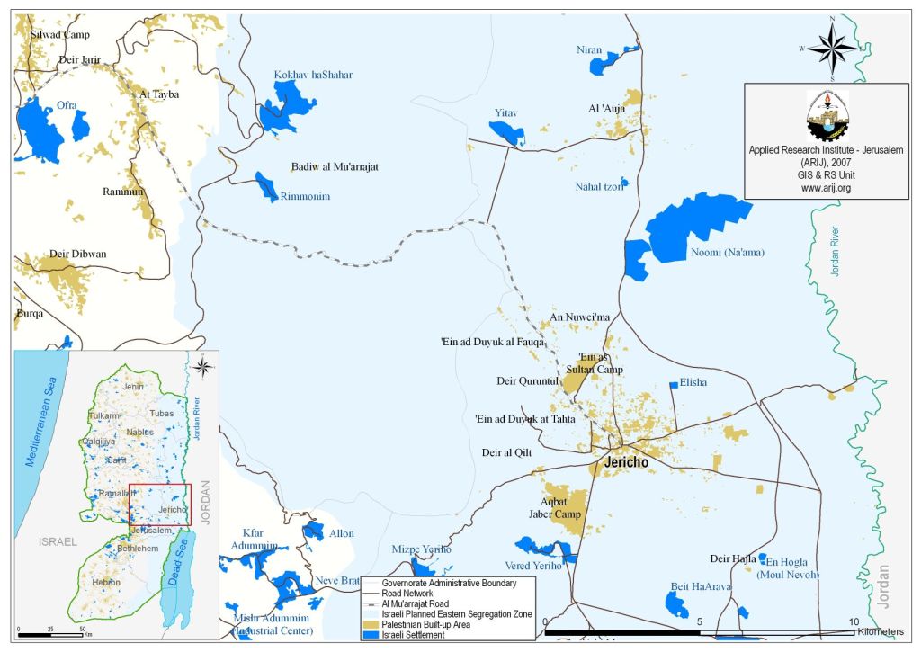
In continuation with its plans to consolidate the segregation of the Jordan Valley from the rest of the West Bank, the Israeli chief commander of the Jordan valley issued an order on May 10, 2007, by which, the Israeli Army is to prevent Palestinians from accessing the sea shores of the Dead Sea under the pretext of “security reasons.” The Dead Sea is the only sea Palestinians of the West Bank were allowed to get to at least until the Army’s order went into effect. However, the Israeli Army started restricting Palestinians from accessing the Dead Sea shores since the outbreak of the second Intifada in September 2000, until the time they made it official under military order. See Map 1

The Dead Sea set at the edge of the eastern part of the Jordan valley, which is a very fertile area that spread on 1664027 dunums of lands and is rich with its water resources. There are about 59970 Palestinian residents living in the area. Since the Israeli occupation of the West Bank in 1967, the Israeli government planned to attach the Jordan Valley area to the Israeli borders claiming that these areas are considered vital and significant to Israel’s security, even more the Israel declared areas of the Jordan Valley a 'State lands' and the rest was classified as closed military areas, but eventually to be claimed the eastern borders of Israel. Since then 42 Israeli settlements comprising an area of 38099 dunums were constructed in the area, they accommodate 12497 Israeli settlers. Moreover, the Israeli Army confiscated some 33045 dunums of lands to construct military bases in the valley area. See table 1 below.
Table 1: Shows the Israeli settlements in the Jordan Valley
|
Settlement |
Date of establishment |
Area/ Dunums |
Population 2002 |
|
Maskiyyot |
1987 |
18 |
507 |
|
Almog |
1977 |
487 |
142 |
|
Argaman |
1970 |
1147 |
179 |
|
Atraqzia |
0 |
478 |
0 |
|
Beit HaArava |
1980 |
484 |
50 |
|
Beqaot |
1972 |
2353 |
168 |
|
Elisha |
1977 |
54 |
753 |
|
En Hogla (Moul Nevoh) |
1982 |
63 |
0 |
|
North Dead Sea (Solar Pond) |
0 |
639 |
0 |
|
Pelas (Ballas) |
1975 |
323 |
0 |
|
Rotem (Nahal Rotem) |
1984 |
40 |
0 |
|
Vered Yeriho |
1980 |
645 |
128 |
|
Massua |
1970 |
2268 |
176 |
|
Maale Efrayim |
1970 |
1370 |
1651 |
|
Yafit |
1980 |
1436 |
150 |
|
Tomer |
1978 |
1031 |
321 |
|
Gilgal |
1970 |
1097 |
124 |
|
Niran |
1981 |
422 |
61 |
|
Noomi (Na'ama) |
1979 |
4942 |
136 |
|
Lido Yehuda |
0 |
1147 |
0 |
|
Shadmot Mehola |
1978 |
1259 |
459 |
|
Elon Moreh |
1979 |
1396 |
1120 |
|
Hamra |
1971 |
1532 |
170 |
|
Gittit |
1973 |
1058 |
123 |
|
Mehola |
1968 |
1759 |
345 |
|
Bitronot (Shila) |
1984 |
128 |
0 |
|
Hemdat |
1980 |
255 |
90 |
|
Roi |
1976 |
1573 |
153 |
|
Netiv Hagedud |
1975 |
1227 |
183 |
|
Yitav |
1970 |
482 |
140 |
|
Nahal tzori |
1981 |
50 |
0 |
|
Kalya |
1968 |
868 |
286 |
|
Avenat |
0 |
124 |
40 |
|
Mizpe Yeriho |
1978 |
934 |
1245 |
|
Maale Mikhmas |
1981 |
86 |
993 |
|
Rimmonim |
1977 |
343 |
567 |
|
'Ayn Fashkhah |
1969 |
97 |
0 |
|
Mshoki Dargot |
1991 |
77 |
80 |
|
Mizpe Shalem |
1971 |
440 |
204 |
|
Mekhora |
1973 |
925 |
154 |
|
Kokhav haShahar |
1977 |
1593 |
1323 |
|
Pezael (Fezael) |
1972 |
1447 |
276 |
|
Total |
|
38099 |
12497 |
Source: ARIJ Database 2007
When Israel decided to establish a so-called “security zone” along the western terrains of the West Bank territory, a parallel zone was also set to establish along the eastern terrains of the West Bank in the Jordan Valley area. However, the eastern segregation zone will not have physical barrier to separate it from the West Bank. Instead, there are about 29 Israeli checkpoints restricting Palestinian Movements in the area of the valley.
Al-Mu'arajat Road
Al-Mu'arajat road is one of the key plans on the Israeli agenda. Israel is planning to expand and pave this road in order to reroute the Palestinian traveling road from north of the West Bank and Jerusalem through Abu Dis and Al-'Ezzariya to Jericho and Bisan reaching Al-Mu'arajat road, which connects Jericho with Ramallah without using the valley road that connects north of the West Bank with its south. Consequently, this will cost Palestinians more time and more money, for example, the current traveling road for Palestinians traveling from Jericho city to Bethlehem is 40 minutes to reach their destination, with the new road it will take them two or three hours and will cost them double the amount they pay.
Expanding Bypass Road # 1
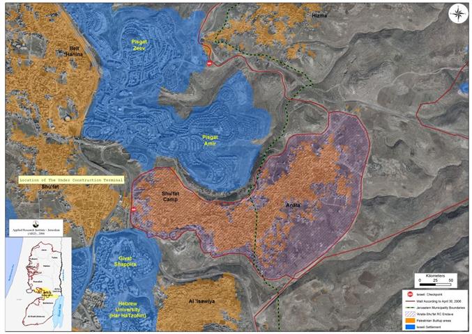
The Israeli bypass road # 1 is the main road connecting Tel Aviv city with Jerusalem. This road penetrates into the West Bank from the eastern side of Jerusalem passing through Ma'ale Adumim and then joining road #90 south of Jericho near the shores of the Dead Sea. The road was constructed on lands confiscated from the Palestinian villages of Az Za'ayyem, Al Ka'abina, Shu'fat, Al 'Isawiya. Recently, Israel started expanding this road to four lanes. It is believed that it will serve as traveling road with Jordan. This comes in correlation with the Israel's plan to create two separated networks of roads in the West Bank one will be used only by Israelis and one for Palestinians. See Map 2
According to the plan the Palestinian road network will extend a length of 583 Kilometers throughout the West Bank whereby the Israeli bypass road will have a length of 859 kilometers of which 794.79 kilometers already exists. As a result, there will be no geographical contiguity between the Palestinian communities except through Israeli controlled areas using tunnels, terminals and certain checkpoints, which again will add to traveling time and costs.
Prepared by
The Applied Research Institute – Jerusalem
ARIJ