Israel, An Alleged State of Democracy!
Israel has long proclaimed itself as a democratic state and even though it is well known what democracy represent, it's hard to apply that same definition of freedom and what it means until you pass through an Israeli checkpoint, at least in the occupied Palestinian territory, where Israel's democracy is tailored to suit their belligerent acts. .
Checkpoints were constructed throughout the Palestinian Territory after the Israeli Occupation in 1967. However, it was not until 1993, that Israel started to become more stringent on these checkpoints, which were set to control and restrict movement of Palestinian within and between Palestinian districts and localities and Israel. A turn of the nature of the different kinds of obstacles (checkpoints is one of them) started immediately to become evident in the year 2000 when movement through these different obstacles became harder than ever before. Nowadays, about 592 different forms of Israeli obstacles planted within the Palestinian territory to restrict and control Palestinians' movement. These different obstacles: checkpoints, earth mounds, iron gates, agricultural gates, and roadblocks divide Palestinian towns and villages into small cantons, which make it very hard for Palestinian residents to move without restraint. According to Article 12 of the International Covenant on Civil and Political Rights (ICCPR), Freedom of movement must be granted to every person in a free state, it states: 'Everyone lawfully within the territory of a State shall, within that territory, have the right to liberty of movement and freedom to choose his residence. Article 3 of the Fourth Geneva Convention of 1949 also strictly prohibits the occupying power from initiating 'violence to life and person' and 'outrages upon personal dignity, in particular humiliating and degrading treatment'.
During the past seven years, the Israeli occupation Army elevated it aggression on the Palestinian people and continued imposing hard complications and harsh restrictions on Palestinian citizens of the West Bank and Gaza, with particular emphasis in the northern area of the West Bank where the Palestinian people has witnessed the establishment of an unprecedented levels in the numbers of checkpoints and other obstacles, used to close all entrances of many Palestinian villages and put up iron gates for people to use in order to reach their residences or land. According to ARIJ's monthly reports, the Israeli Army established 121 flying checkpoints and 8 iron gates during the period of October 2006 until April 2007. Table one below illustrate the number of flying checkpoints and iron gates erected in the West Bank during the aforementioned period.
Table 1: Number of flying checkpoints and iron gates during the period of October 2006 until April 2007
|
Month |
Governorate |
# of flying checkpoints |
# of iron gates |
|
October 2006 |
Tubas |
5 |
0 |
|
Jenin |
2 |
0 |
|
|
Nablus |
4 |
1 |
|
|
Salfit |
1 |
4 |
|
|
November 2006 |
Jenin |
5 |
0 |
|
Nablus |
6 |
0 |
|
|
Tulkarm |
1 |
0 |
|
|
Bethlehem |
1 |
0 |
|
|
Salfit |
1 |
0 |
|
|
Ramallah |
1 |
0 |
|
|
Tubas |
15 |
0 |
|
|
December 2006 |
Bethlehem |
|
1 |
|
Qalqiliya |
1 |
0 |
|
|
Tubas |
3 |
0 |
|
|
Nablus |
6 |
1 |
|
|
Jenin |
1 |
0 |
|
|
Tulkarm |
1 |
0 |
|
|
January 2007 |
Qalqiliya |
1 |
0 |
|
Salfit |
1 |
0 |
|
|
Nablus |
3 |
0 |
|
|
Tubas |
7 |
0 |
|
|
Jenin |
10 |
0 |
|
|
February 2007 |
Bethlehem |
1 |
0 |
|
Tubas |
3 |
0 |
|
|
Nablus |
2 |
1 |
|
|
Jenin |
7 |
0 |
|
|
Tulkarm |
1 |
0 |
|
|
March 2007 |
Jenin |
6 |
0 |
|
Hebron |
3 |
0 |
|
|
Tulkarm |
1 |
0 |
|
|
Qalqiliya |
4 |
0 |
|
|
Salfit |
5 |
0 |
|
|
Nablus |
1 |
0 |
|
|
Tubas |
2 |
0 |
|
|
April 2007 |
Salfit |
3 |
0 |
|
Tubas |
3 |
0 |
|
|
Jenin |
3 |
0 |
|
|
Total |
121 |
8 |
|
Source: ARIJ's monthly reports
What is 'flying checkpoints?'
The term may sound unfamiliar to many living in other society and even though they might experience one randomly and quickly, it is incomprehensible for them that they have to deal with it almost on a daily basis and for prolonged periods. Flying checkpoint is in fact a roadblock operated by Israeli soldiers and is set up randomly on Palestinian roads supposedly for security checks. Palestinians who has to deal with flying checkpoints usually has to wait sometime ranging from 20 minutes to 90 minutes and in certain areas more than that. Its impact is more of a psychologically nature and more devastative than permanent checkpoints. Most of the flying checkpoints in the West Bank occur in the northern part of the West Bank particularly in Nablus, Tubas and Jenin governorates. It is worth mentioning that Palestinian residents (Students, workers, children and women) have a hard times accessing these checkpoints and are forced to wait long hours until they are finally allowed to pass. These restrictions make it difficult for Palestinians to reach their destinations, to access hospitals, schools and universities. Other than that Palestinians crossing the Israeli checkpoints has to deal with the Israeli soldiers mood swings as people often get humiliated, attacked, assaulted or beaten. Tables below show the Israeli checkpoints surrounding the northern governorates of the West Bank.
Table 2: Israeli checkpoints surrounding Nablus governorate
|
Israeli checkpoint |
Glance about the checkpoints |
|
Za'tara checkpoint |
Lies 11 kilometers to the south of Nablus city and is situated on bypass road # 60. This Israeli checkpoint was established on the expense of Palestinian lands of Huwwara and Iskaka villages. Za'tara checkpoint is the gateway between the northern Palestinian governorates Jenin, Tulkarm and Nablus with the middle and southern governorates of Ramallah, Jerusalem, Bethlehem and Hebron. It also links the western governorates of Qalqiliya and Salfit with the eastern governorates of Tubas and Jericho in the Jordan valley. |
|
Huwwara |
It Is located 4 kilometers south of Nablus city and is considered as one of the most restricted checkpoints in the West Bank. Palestinians traveling through this checkpoint usually face the daily restriction on movements as no men under the age of 35 are allowed to cross under any circumstances. |
|
Beit Iba |
It Is located 8.5 kilometers to the northwest of Nablus city; it lies between the two villages of Beit Iba and Deir Sharaf. This checkpoint is considered the only gateway to the governorates of Qalqiliya and Tulkarm. Beit Iba checkpointopens daily from 05:00 A.M until 17:30 PM. Men under the age 30 are not allowed to cross the checkpoint unless they have special permit from the Israeli Civil Administration. |
|
Beit Furik |
Located about 3.5 kilometers to the east of Nablus city. It controls the movement of five Palestinian villages trapped into two separate enclaves, the first includes the villages of Beit Furik and Beit Dajan while the second enclave includes the villages of Salem, Deir El Hatab and Azmut. An Israeli road cuts through the two enclaves, which leads to the Israeli settlement Allon Moreh. Palestinians are prohibited from accessing this road as it is only used by the Israeli settlers of Allon Moreh and Itamar. |
|
'Asera Ash Shamaliya |
It is located 5 kilometers northwest of Nablus city. This checkpoint is designated to pedestrians. Vehicles are incapable to cross through due to the several earth mounds layers set up by the Israeli Army. |
|
'Awarta |
It is located 3.5 kilometers to the south of Nablus city and about one kilometer from Huwwara checkpoint. This checkpoint is used for moving goods in and out of the city. 'Awarta checkpoint opens daily between 6 A.M and 6 P.M. |
|
Shave Shomron |
Shave Shomron checkpoint, is the only gateway way between Nablus and Jenin governorates. It lies 10.5 kilometers northwest of Nablus city and its use is restricted to Palestinians holding special permits from the Israeli Civil Administration. |
|
At Tur |
Lies 2 kilometers to the southwest of Nablus city and connects the Samaritan district of Jerzim with Nablus city. This checkpoint opens only for Samaritans and occasionally opens for Palestinian vehicles. |
|
Ma'ale Efrayim |
Located 16.5 kilometers southeast of Nablus city. It connects Jericho governorate with Nablus Governorate. This checkpoint is classified amongest the most difficult checkpoints established in the West Bank as Palestinians accessing this checkpoints face the harshest inspection measures until they're allowed to enter Nbalus Governorate. |
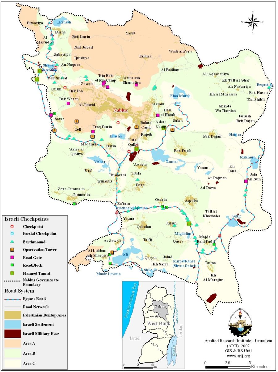
See map of checkpoints in Nablus Governorate.
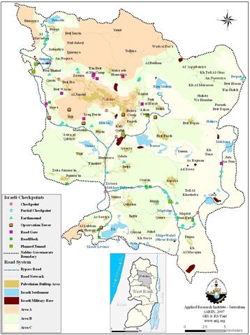
Table 3: The Israeli checkpoints surrounding Jenin governorate
|
Israeli checkpoint |
Glance about the checkpoints |
|
Salem DCL (District Civilian Liaison Office) |
Located 12.25 kilometers to the northwest of Jenin city on the 1949 Armistice Line (Green Line). It's the only entrance to Jenin, the Israel DCL office and the nearby military base. Palestinians are only allowed to pass through this checkpoint to access the DCL office. The checkpoint opens seasonally to farmers, mainly in harvest times as to allow Palestinian farmers from harvesting their products. |
|
Reikhan |
It was inaugurated in August 2004. It lies 17.25 kilometers to the west of Jenin city. Construction works and militarized activities are taking place at the checkpoint in an attempt to turn it into a crossing border. |
|
Mevo Dotan |
Located 11.5 kilometers to the southwest of Jenin city. It is connected with the regional road # 585. |
|
Al Jalama commercial terminal |
Al Jalama terminal is one of the 10 main terminals Israel announced to construct in September 2004 along the Occupied Palestinian Territory. Al Jalama a is Back-to- Back terminal which lies on the 1949 Armistice Line (Green Line) to the north of Jenin city. |
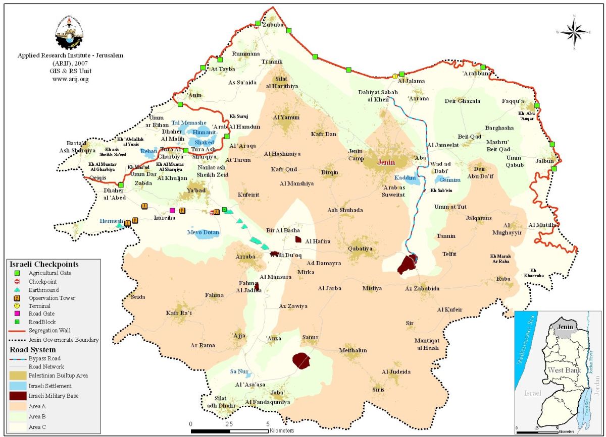
See map of checkpoints in Jenin Governorate.
Table 4: The Israeli checkpoints surrounding Tulkarem governorate
|
Israeli checkpoint |
Glance about the checkpoints |
|
Jubara |
Located 4 kilometers to the south of the Palestinian city of Tulkarm. The checkpoint lies on road #557 which connects cities inside the 1949 Armistice Line (Green Line) with towns and villages in Tulkarem Governorate. |
|
Al Kafriat |
It is located at the southern entrance of Tulkarm city and serves farmers from Far'oun and Ar-Ras villages. |
|
Al Tayba |
Located to the southwest of Tulkarm city on the 1949 Armistice Line (Green Line). This checkpoint is open for trades using the commercial Back-to-Back system. Official opening hours are from 7:30 A.M to 17:00 P.M and closes on Saturdays. |
|
'Anabta
|
It is situated on Nablus-Tulkarm roadway. The Israeli forces manning the checkpoint do not allow Jenin residents to cross it and it is usually closed to men under the age of 35. |
|
Sha'ar Ephraim (Commercial Terminal)
|
Sha'ar Ephraim terminal located in Tulkarem governorate and classified a commercial passage for merchandise between northern governorates and Israel. It is also to be used be Palestinians in possession of Israeli issued permits to enter Israel for employment purposes. The terminal, which stands as an integrated part of the Israeli Segregation Wall built on Tulkarem's lands has been under construction for sometime. |

See map of checkpoints in Tulkarm Governorate
Table 5: The Israeli checkpoints surrounding Qalqiliya governorate
|
Israeli checkpoint |
Glance about the checkpoints |
|
Qalqiliya north |
It is located about one kilometer to the north of Qalqilyah city and operates daily from 4:00 A.M- 19:00 P.M. The checkpoint is for pedestrians use only; vehicles are prevented from crossing it. |
|
Jaljoulia |
Located 3 kilometers away from the 1949 Armistice Line (Green Line). Access is only granted to those holding permits and it opens 24 hours a day. |
|
Jit |
This checkpoint lies 20 kilometers to the northeast of Qalqilyah city, on Nablus- Qalqilyah roadway. |

See map of checkpoints in Qalqiliya Governorate.
Table 6: The Israeli checkpoints surrounding Salfit governorate
|
Israeli checkpoint |
Glance about the checkpoints |
|
Kafr Kasem |
It is located 0.7 kilo meters meters away from the Green line and is situated 17 kilometers to the northwest of Salfit city. |
|
Deir Ballut |
Located 13.5 kilometers to the west of Salfit governorate and opens from 6:30 A.M – 18:00 P.M. |

See map of checkpoints in Salfit Governorate.
Table 7: The Israeli checkpoints surrounding Tubas governorate
|
Israeli checkpoint |
Glance about the checkpoints |
|
Bisan |
Situated on the 1949 Armistice Line (Green Line) and lies 15 kilometers to the northeast of Tubas city. This checkpoint is manned 24 hours a day by Israeli forces. |
|
Tayasir |
Located 6.8 kilometers to the east of Tubas city. It was established near the Jordan Valley at the outbreak of the Second Intifada. It's considered to be the first checkpoint that drew an eastern border of the West Bank. It has been recently replaced by a terminal-like building in which electronic devices are used. |
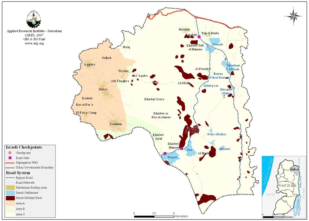
See map of checkpoints in Tubas Governorate.
To Conclude
Despite international condemnation, Israel continues with its plan to erect more and more illegal checkpoints in an attempt to isolate the northern part of the West Bank from its south. More than that, Israeli checkpoints intend to humiliate Palestinians and have caused the death of hundreds over the years. All the Israeli established obstacles throughout the occupied Palestinian territory are used by Israel as another tool of collective punishment, which is forbidden under international law.
Prepared by
The Applied Research Institute – Jerusalem
ARIJ