The Israeli Occupation Army handed out residents of El Ezariyeh and At-Tur cities, Palestinian suburbs southeast of occupied East Jerusalem city, a map showing a network of roads to be constructed on lands belongs to the two communities. According to the analysis of the Israeli map conducted by the GIS unit at the Applied Research Institute – Jerusalem (ARIJ), the road network will extend a total length of 13 km starting east of El Ezariyeh at the intersection to bypass road number 417 that leads to Ma’ale Adumim settlement, after which, the road starts shaping westward to At-Tur lands near the Israeli bypass roads number 1. The Israeli newly designed road obviously aim to serve couple of major purposes; the first is to encompass much of the open spaces of theses two communities and the second is to end Palestinian use of bypass road number 417 that leads to northern districts in the West Bank.
ARIJ GIS analysis shows that the planned road network will confiscate a total of 809 dunums of lands of the two communities for the route of the road; 567 Dunums of which belong to El Ezariyeh where the bypass road is set to run a length of 9 kilometers, while the remaining 242 Dunums will come from At-Tur where the bypass road will extend a length of 4 kilometers. See Table 1
Table 1: Lands confiscated from of At-Tur and Al Ezariyeh communities
southeast of occupied East Jerusalem city.
|
Community |
Area confiscated from village Boundary (Dunums) |
Total Road length within village Boundary (km) |
|
AL EZARIYEH |
567 |
9 |
|
AT-TUR (SCOPUS AREA) |
242 |
4 |
|
Total |
809 |
13 |
Source: ARIJ GIS Database 2007
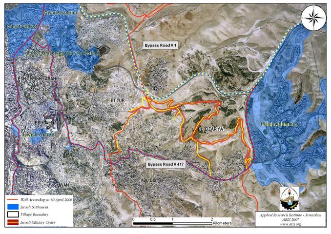
Clearly, the Israeli map aims to consolidate control of isolated open space areas that belong to several Palestinian communities in the area, among which are El Ezariyeh and At-Tur. The targeted open space area is designated for the Ma’ale Adumim “E1” neighborhood annex. Furthermore, the planned road will establish an Israeli controlled security buffer zone between the planned roads and the Segregation Wall and bypass road number 1 that includes additional open space area in between, which will become out of any future urban development plans for the Palestinians in that area. More than that, the newly designed Israeli road will end Palestinians in the southern part of the West Bank (Bethlehem, Hebron and several Palestinian communities in East Jerusalem) from using bypass road number 417 that leads to the Palestinian northern district and to Jericho thus consolidating the Israeli plan to isolate the eastern Segregation Zone and substantiate Ma’ale Adumim settlements bloc merge with isolated and occupied East Jerusalem toward Israeli controlled areas. See Annex 1 & Annex 2 for more info about Bypass Road number 417 and Bypass Road number 1. See map of proposed Road Network
Al Ezarieh and At-Tur Towns – Geography (Area, Location and population)
Two Palestinian suburbs located southeast of Jerusalem city. The two suburbs are bordered by the Israeli settlement of Ma'ale Adumim at the east, the Palestinian town Silwan and the Jewish Quarter from the West, the Palestinian towns Abu Dis city from the south and Ez Zi'em from the north.
Population and Area
The town of Al Ezarieh is a home to 17398 Palestinian inhabitants according to the Palestinian Central bureau of statistics – 2006. The town spreads on 11049 dunums (11.049 km²) 4439 Dunums of which are forests and open spaces located at the eastern part of the town where the areas are designated for the future urban expansion of the town.
At-Tur town sets on a total land area of 8715 dunums (8.715 km²) and is a home to more than 12000 inhabitants according to PCBS 2006. The bulk of the land areas (5332 dunums) are forests and open spaces at the eastern part of the town. See Table 1 – Land Use Land Cover of At-Tur and El 'Ezariyeh Towns.
|
Land Cover Type |
Land Use Land Cover of At-Tur Town |
Land Use Land Cover of Al 'Ezariyeh Town |
|
|
|
|
|
Agricultural Lands |
766 |
771 |
|
Forests & Open Spaces |
5332 |
4439 |
|
Israeli Settlement |
566 |
3434 |
|
Palestinian Built-up Area |
1705 |
2379 |
|
Israeli Military Base |
335 |
8 |
|
Segregation Wall |
11 |
18 |
|
|
|
|
|
Total |
8715 |
11049 |
Source: ARIJ GIS Database 2006
Land Classification of Al Ezariyeh Village
In the Oslo II Interim Agreement, signed in September 1995 between the Palestinian Liberation Organization (PLO) and Israel, the Palestinian occupied territory was categorized into three dominance, which became known as areas A, B and C as a preliminary step to phased withdrawal of the Israeli military forces from the West Bank area until the accomplishment of a final status agreement.
-
Area A: constitutes the areas where the Israeli army has pulled out fully and Palestinians have complete autonomy over administrative and security issues. Area A, according to the Oslo II agreement, covered the main cities of the West Bank, except for Hebron.
-
Area B: Palestinians have full control over the civil responsibilities and Israel continues to have overriding responsibility for security.
-
While Area (C): Palestinians have responsibility for civil life such as economics, health and education; however, Israel retains full control over security and administration related to territory.
Accordingly, the 11049 dunums of Al Ezariyeh town lands were classified to areas B and C; 3273 dunums of which were classified as Area B (29.6 % of the total town area) where most of the built up area of the village is concentrated; while the remaining of the area, a total of 7776 dunums of Al Ezariyeh town lands were classified as Area C (70.4 % of the total town area) and contain all the open spaces in the town.
in the same pattern, the 8715 Dunums that comprised At-Tur town were classified to areas B & C; 236 dunums of which were classified as Area B (2.7% of the total land area) while the rest of the area, a total of 8479 dunums of At-Tur Town lands were classified as Area C (97.3 % of the total lands area) and constituted the majority of forests and open spaces in the town. See Table 2
|
Classification of Lands in Al Ezarieh town and At-Tur village according to Oslo II Agreement of 1995 |
Area A (Dunum) |
Area B |
Area C |
Total |
|
|
|
|
|
|
|
El 'Ezarieh Town |
0 |
3273 |
7776 |
11049 |
|
Percent of the total Land Area |
0 |
29.6 |
70.4 |
100 |
|
|
|
|
|
|
|
At-Tur Town |
0 |
236 |
8479 |
8715 |
|
Percent of the total Land Area |
0 |
2.7 |
97.3 |
100 |
Source: ARIJ GIS Unit – 2006
The Israeli Colonial program on lands of Al Ezariyeh and At-Tur communities
Following the Israeli Occupation of the West Bank (including East Jerusalem) and the Gaza Strip in 1967, Israel started its colonial program in the territory; building settlements, construct bypass roads, build military bases, all of which severely affected land and people.
In 1971, both towns, Al 'Ezarieh and At-Tur lost considerable shares of their lands (3434 dunums and 401 dunums respectively) for the establishment of Ma'ale Adumim settlement; in addition, The town of At-Tur town lost at earlier time more of its lands, 163 dunums for the Israeli industrial zone Mishor Adumim (est. 1974) which is part of the Ma'ale Adumim settlements Bloc and the other location is Hebrew University (Har Ha Tzofim) (est. 1968).
The two towns also lost more of their lands for the construction of two main bypass roads, bypass road number 417 which dissects the southern part of Al 'Ezariyeh town, extending 6.5 kilometers from east to west and connecting the Ma'ale Adumim settlement Bloc with settlements inside Jerusalem and inside Israel; and Bypass road number 1 which dissects the northern part of At-Tur Town, extending 5.1 kilometers from east of At-Tur where it moves westward before it continues northwards in the direction to Al Esawiyeh town. The road also connect settlements of the Jordan Valley when it runs near Ma’ale Adumim settlement with Jerusalem and consequently with Israel.
The Israeli Segregation Wall swallowing the lands of Al 'Ezariyeh and At-Tur Towns
Today, the two towns are among the many Palestinian towns and villages that suffered the loss of their lands for the construction of the Israel Segregation Wall.
The Segregation wall path has been subjected to several changes, the latest of which was in April 30, 2006 and showed a 703 kilometers wall to be constructed on lands of the West Bank, from north to south (307 kilometers of which, are already constructed).
In Al Ezariyeh town, the wall will eat up some 56% of its lands, the majority of which are forests and open spaces designated for the future urban expansion of the town. The Wall will also exclude the majority of the town’s Jerusalemites population on the other side of the Wall inside the West Bank. Families will be torn apart and many of them will lose access to education and health services inside the city of Jerusalem as well as the risk of losing their Jerusalem residency.
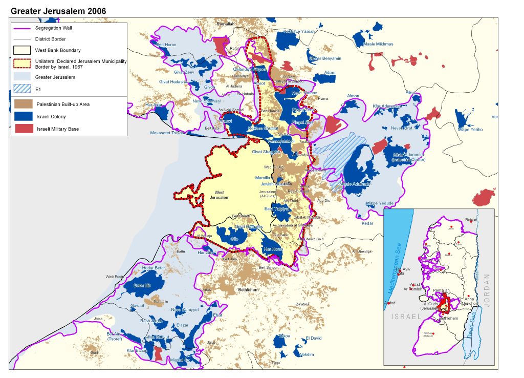
The section of the wall which is being built on lands of Al Ezariyeh (7.3 kilometers) constitutes part of the Segregation Wall planned to enfold Ma'ale Adumim settlements bloc to annex it to Jerusalem as made clear in the Israeli vision of 'Greater Jerusalem', which includes annexing the four main settlements blocs that surround Jerusalem (Ma'ale Adumim Settlements Bloc, Gush Etzion Settlements Bloc, Giv'at Ze'ev settlements Bloc and Benyamin settlements Bloc). see map of Greater Jerusalem
See table 3 for more details
Table 3: Land Use Land Cover of Al Ezarieh Town – southeast of Jerusalem city.
|
Classification of Land Use Land Cover (LULC) |
Land Use Land Cover of El Ezariyeh Town |
LULC Of Al Ezarieh town segregated lands |
Percent of the Town's total land Area |
|
|
|
|
|
|
Agricultural Lands |
771 |
57 |
0.5 |
|
Forests & Open Spaces |
4439 |
2505 |
22.7 |
|
Palestinian built-up area |
2379 |
154 |
1.4 |
|
Israeli Military Base |
8 |
8 |
0.1 |
|
Israeli colony |
3434 |
3434 |
31.1 |
|
Segregation Wall |
18 |
12 |
0.1 |
|
|
|
|
|
|
Total Area |
11049 |
6170 |
55.8 |
Source: ARIJ GIS Unit – 2006
In Al Tur case, the majority of its lands (8370 dunums) are already included within Jerusalem city borders with the exception of 345 dunums of lands on the West Bank side on which part of the town’s built-up area is located, where the residents will have similar fate to those in Al Ezariyeh who will likely to lose their Jerusalem residency rights accordingly.
Prepared by
The Applied Research Institute – Jerusalem
ARIJ