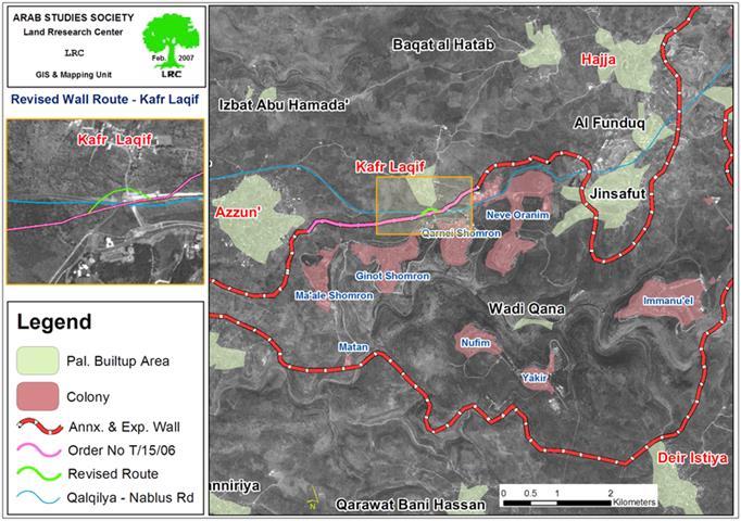

(Photo 1: A resident of Kafr Qaddum standing atop a pile of rocks
blocking an agricultural road in the village )
As part of the Israeli occupation's policy of harassment, closure and economic punishment the Israeli army closed with earth mounds and rocks all the main and sub agricultural roads in Kafr Qaddum villages, Qalqiliya governorate preventing farmers and land owners from tending their fields in the area. The following agricultural roads were closed:
1. The main agricultural road connecting between the lands of Kafr Qaddum and northern lands of Beit Lid;
2. The western agricultural road that links between Kafr Qaddum and Kur;
3. The internal agricultural road under the name of 'Asafa which links between Qafr Qaddum's southern and eastern lands;
4. The main agricultural road that connects between Kafr Qaddum and and Hajja.
The road closure started last autumn during the olive harvesting season and is still in force despite all the efforts that were carried out to lift it. As a result, farmers and land owners have suffered heavy material losses as they were unable to harvest the olive yields and to cultivate winter crops in their unreachable fertile fields.
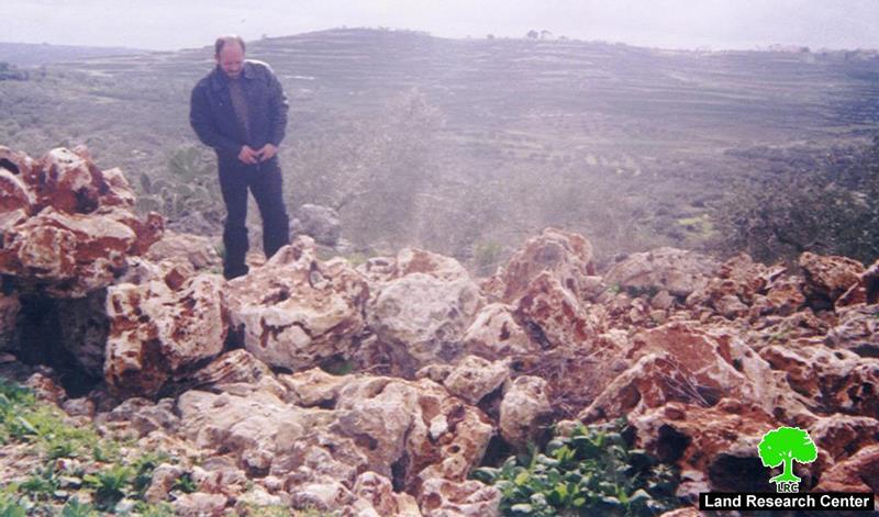
(Photo 2: in the upper right corner is the colony of Kadommim and
in the middle is a closed agricultural road)
Settler violence
In the meanwhile groups of armed settlers and soldiers in official uniform intensified their acts of provocation against the Palestinian land owners and farmers trying to reach their fertile agricultural fields east and south of the village using alternative roads. The farmers own about 350 dunums cultivated with ground seasonal crops and olive trees in these two areas which are located about 300 meters from the colony of Kadumim pausing no danger to the colony's security as the Israeli occupation usually claims.
The farmers have been intimidated by live and rubber fire shoots, sound bombs and chasing so as to force them out of the target area. Also, the settlers protected by army soldiers continue to destroy crops, uproot trees and damage terraces and retaining walls and all sorts of agricultural installations in the area. In addition, dozens of wild pigs were introduced into the area by the Israeli occupation authorities with the aim of destroying Palestinian agriculture.
The village local council had extended many warnings and appeals to the International Committee of the Red Cross (ICRC), the District Coordination Office (DCO) in Qalqiliya against the settler's attacks and violations, but to no avail.
Location and Population
The village of Kafr Qaddum is located 13 kilometers south west of the city of Nablus and 22 kilometers east of the city of Qalqilia. The latest statistics indicate that the population of the village stands at 3,500 individuals.
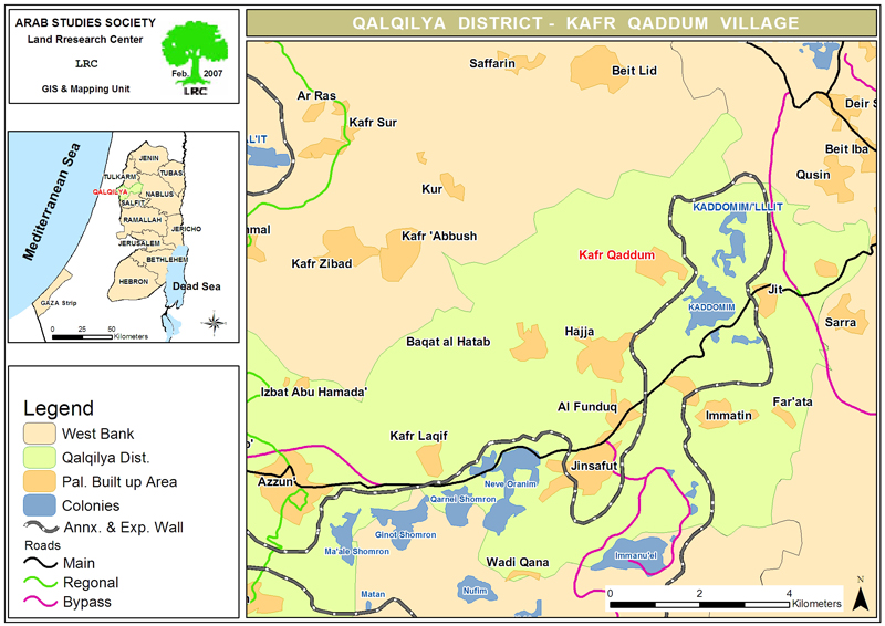
(Map 1: location of Kafr Qaddum – Map prepared by LRC)
Before the current Intifada about 50% of the families of the village used to depend on working inside of Israel as the main source of income, 20% depended on agriculture and animal rising, while 30% depended on jobs in the private and public sectors. Yet after the year 2002 more than 75% of the population became jobless as business became the only other alternative for income generation. About 280 family out of the total of 640 family are dependent on foreign aid for living. In addition, immigration has registered a record level during the past two years ranging between 10-15 % of the total population.

(Photo 3: Citizens of Kafr Qaddum receiving foreign aid in the village )
Surface Area
The village's original total surface area is 17161 dunums of which 529 dunums are built up area. About 7,000 ( 40%) of its original land is under Israeli settlement control (the colonies of Kaddomim and Kaddomim Illit). The reaming lands are distributed as follows:
-
80% are planed with Roman olive trees.
-
15% are used for vegetation purposes.
-
5% are planted with crops.
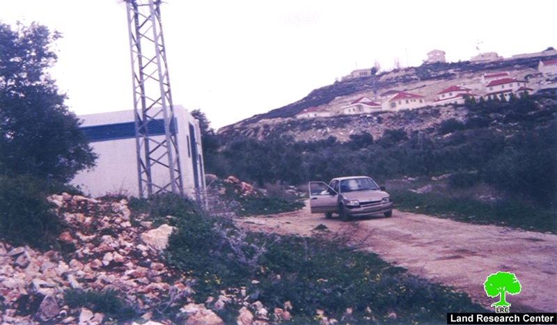
Kaddomim colonial block
The colony of Kaddomim was established in 1975 and then extended north and south to become one of the biggest colonies in the occupied West Bank. During this on going expansion process, the colony of Kaddomim Illit (Kaddomim North) as well as the colony of Jabel Mohammed (Kaddomim South) were also founded at the expense of the lands of the Palestinian village of Kafr Qaddum. Now, kaddomim block is formed of five colonies with a total surface area ( built up and municipal area) of 5000 dunums. At the end of 2004, the total number of settlers living in these five colonies reached 3010, according to the Foundation for Middle East Peace.
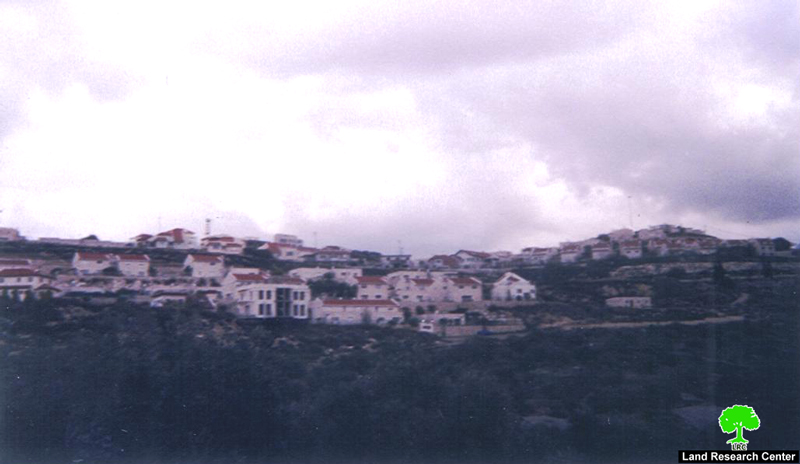
(Photo 4: a picture of kadommim colony )
Segregation Wall
At the end of 2994, the Israeli occupation forces distributed plans to construct a section of the Segregation Wall at the eastern, southern and northern sides of Kafr Qaddum village for the purpose of annexing the kaddomim colonial block into Israel. If this plans were put in action, more than 9000 dunums of Kafr Qaddum's agricultural lands (about 50% of its total land area) would be destroyed, confiscated or separated behind the Wall, particularly, in the eastern part of the village where 55% of the population are dependent on seasonal winter and summer ground crops as main income after losing their jobs inside Israel.
Closing of main road
Shortly after the outbreak of the current Intifada in the year 2000, the Israeli occupation forces closed the main Kafr Qaddum- Nablus road under security claims forcing local people to look for alternative roads. One of these agricultural un- paved alternative roads takes a circular route through the villages of Hajja, Al Funduq, Immatin and Jit before reaching the main checkpoint to Nablus city. If takes this, one has to travel 22 km instead of the ordinary 10 km journey.
Poor village infrastructure
The village suffers poor infrastructure as there is no electricity power and people have to depend on small electric generators. Moreover, the existing water network is in a very bad situation where leakage reaches up to 45%. Most roads are still un paved inside the village and there is a need for schools and health centers.
Prepared by
The Land Research Center
LRC