On the 23rd of November 2006, the Israeli Army handed out residents of Kfar Ad Dik and Deir Ballut villages, a new military order to confiscate lands for military purposes, mainly to construct the Segregation Wall. The military order holds number 82/06/T and stipulates the confiscation of 538.7 dunums from lands of the two villages. See translation of the military order.
Table 1: Translation of military order number (82/06/T))
|
Israel Defense Forces Order to Seize lands n0 82/06/T
According to my authorities as a Military Chief Commander in the Region of Judea and Samaria, and as I believe that it is imperative for military reasons due to the special security situation in the region, I order the following:
1- In This Order:
The 'Map' – signed in scale 1: 20000 and attached to the order is an essential part of this order.
The 'Lands' – An area of land which is 583 dunums and 700 hundred meters marked in red in the map and is located in lands of:
Deir Ballut
Kfar Ad Deik
2- I announce by that the above mentioned lands are seized for imperative military purposes, to construct the security Wall in Fedual area on lands of Deir Ballut and Kfar Ad Deik.
3- The IDF seize the lands and an absolute control of the land is given to the Military Chief Commander of the Central Region through the Ministry of Defense Chief Officer in the Civil Administration Office.
4- Land Owners have the right to go to the District Coordination Office in Qalqilyah to get usage expenses and compensation.
5- Copies of this military order and the attached map are handed out to Land owners or to the District Co-ordination Office in Qalqilyah.
5A-1- This military order is to be notified to Land Owners or those who act on behalf of them by posting it at the District Coordination Office in Qalqilyah and dispersing it on the lands by any possible mean.
5A-2: The date of the field visit conducted by the District Coordination Office in Qalqilyah to present the lands.
5B- Copies of the military order and the attached map are available for interested parties at the following places:
5C- Copy of the military order and the attached map is set at Qalqilyah District Coordination Office Board for 10 days from the issuance date of the military order, as mentioned in Part (5A).
6- Land owners or those who act on behalf of ownership have the right to object the military order in 7 days from the date of the field visit as mentioned in Part (5A) above through the District Coordination Office in Qalqilyah or at the Office of the juridical advisor in the region.
8- This order is valid from the date it was signed and until 31/12/2009.
9- This order is called: 'Order to seize lands n0 82/06/T (Judea & Samaria) 5765-2005.
Ya'er Naveh
|
According to the military order, the Wall is set to penetrate through the lands of these two villages, which will result in the isolation of more than 8 thousands of the two Palestinian villages causing disastrous impacts on residents of these villages. Deir Ballut village is one of dozens of Palestinian villages that will be trapped into ghettos and will suffer from the Israeli restrictions on the long run.
The case of Deir Ballut
Deir Ballut, a Palestinian village located 41 km west of the city of Nablus. The village occupies a total area of 11020 dunums (approximately 11 km²), of which, 429 dunums (0.492 km²) takes constitutes the village's built-up area that houses 3,681 Palestinian inhabitants(PCBS, 2006). The village is bordered with the 1949 Armistice Line (the Green Line) from the west, two Israeli settlements (Peduel, est. 1984 and Har Alei Zahav, est. 1982) from the east, Rafat village from the north and Al Lubban and Rantis villages from the south.
Land Classification of Deir Ballut Village
Under the Oslo II Interim Agreement that was signed in September 1995 between the Palestinians and Israelis, the Palestinian areas in the West Bank were categorized into three areas A, B and C which aimed at a phased withdrawal of the Israeli military forces from these areas B and C until the accomplishment of a final status agreement.
-
Area A: constitutes the areas where the Israeli army has pulled out fully and Palestinians have complete autonomy over administrative and security issues. Area A, according to the Oslo II agreement, covered the main cities of the West Bank, except for Hebron.
-
Area B: Palestinians have full control over the civil responsibilities and Israel continues to have overriding responsibility for security.
-
While Area (C): Palestinians have responsibility for civil life such as economy, health and education; however, Israel retains full control over security and administration related to territory.
Accordingly, the 11020 dunums of Deir Ballut Village were classified to areas B and C; 585 Dunums of which were classified as Area B (5.3 % of the total village area) where the remaining land area, a total of 10435 dunums of Deir Ballut village lands were classified as Area C (94.7 % of the total village area) where all the agricultural lands, the open spaces areas and lands reserved for future expansion of the village's built-up area exist. See Table 2 & Map 1
|
Table 2: Classification of Lands in Deir Ballut village according to Oslo II Agreement of 1995 |
||
|
Classification of Area |
Area in dunums |
% of the Village's total area |
|
Area A |
0 |
0 |
|
Area B |
585 |
5.3 % |
|
Area C |
10435 |
94.7 % |
|
Total Area |
11020 |
100 % |
|
ARIJ GIS Database – 2006 |
||
Source: Geographical Information system Unit 2006 -ARIJ
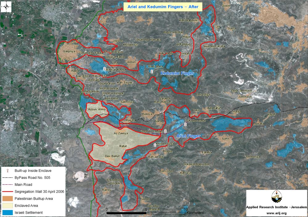
According to the Israeli Segregation Wall plan of 30 April, 2006 which was published on the Israeli ministry of defense website, the village of Deir Ballut, along with the villages of Az Zawiya and Rafat (housing a total population of 10700 – PCBS 2006) will be trapped in an enclave by the Israeli Segregation Wall. A total of 19.648 km length of the Segregation Wall will surround the three villages from all directions, east, west, north and south, eventually entrapping and isolating more than 24000 dunums from the surrounding Palestinian communities.
The movement of residents of the three villages will be totally affected by the construction of the Segregation Wall. It is believed that an underground road or tunnel will be constructed underneath the Israeli Bypass Road 505 to link the three Palestinian villages with the closest neighboring Palestinian community to the north to Masha village in order to access the West Bank.
Out of the total Segregation Wall length surrounding the three Palestinian villages of Rafat, Az Zawiya and Deir Ballut, a total of 10.472 km (53.3%) of the Segregation Wall will come on the western, southern and eastern peripherals of Deir Ballut and will cause the isolation of 4068 Dunums (37 %) of the village's total area; in addition to annexing the two Israeli settlements of Alei Zahav and Peduel located to the east of the village to Israel's proper. Table 3 below details the isolated Land Use Land Cover of Deir Ballut village land inside the Segregation Wall.
Table 3: Land Use Land Cover of classification of Deir Ballut village
|
Land Use Land Cover Classification of Deir Ballut village |
Total Village area (dunums) |
Total isolated lands due to wall constructions |
Percent of Isolated lands from total village boundary |
|
Arable land |
1383 |
441 |
4.0 |
|
Heterogeneous agricultura |
10 |
9 |
0.1 |
|
Jewish settlements |
237 |
237 |
2.2 |
|
Open spaces with little o |
3450 |
1992 |
18.1 |
|
Palestinian Built-up Area |
429 |
0 |
0.0 |
|
Permanent crops |
3432 |
485 |
4.4 |
|
Plastic Houses |
1 |
0 |
0.0 |
|
Shrub and/or herbaceous v |
2078 |
904 |
8.2 |
|
Total Area |
11020 |
4068 |
36.9 |
Source: Geographical Information system Unit 2006 -ARIJ
The case of Kfar Ad Dik village
Kfar Ad Dik, a Palestinian village located to the far west of Salfit city. The village is a home to 5147 Palestinian residents (PCBS -2006) and occupies a total area of 12656 dunums, out of which, 620 dunums of which makes the village's Built-up area. The village is bordered by the two Israeli settlements of Peduel and Har Alei Zahav from the east, Bruqin and Kherbit Sua from the north, and Bani Zeid from the south.
According to Oslo II Interim Agreement that was signed in September 1995, the village of Kfar Ad Dik was classified to areas A, B and C as indicated in the analysis conducted by the GIS unit at the Applied Research Institute, which shows that a total of 1530 dunums of lands are classified as Area A, 5188 dunums were classified as Area B, while the remaining area of the village, 5938 dunums are classified as Area C. See Table 4 below:
|
Table 4: Classification of Lands in Kfar Ad Dik village according to Oslo II Agreementof 1995
|
||
|
Land Classification |
Kfar Ad Dik
|
% |
|
Area A |
1530 |
12.1 |
|
Area B |
5188
|
41 |
|
Area C |
5938
|
46.9 |
|
Total |
12656 |
100 |
|
ARIJ GIS Database – 2005 |
||
ARIJ GIS Database – 2006
The Segregation Wall threatening the lands of Kfar Ad Dik
The village of Kfar Ad Dik is also threatened by the construction of the Segregation Wall. Military order number 82/06/T confiscates some of its land for that purpose too.
In An analysis conduct by the GIS unit at the Applied Research Institute Jerusalem showed that the village of Kfar Ad Dik will lose a total of 4287 Dunums (34 %) of its lands according to the Israeli Segregation Wall plan that was published on the Israeli Ministry of defense website on April 30, 2006. See Table 5
|
Land Use Land Cover Classification of Deir Ballut village |
Total Village area (dunums) |
Total isolated lands due to wall constructions |
Percent of total village boundary |
|
Arable land |
680 |
475 |
3.8 |
|
Forests |
85 |
0 |
0 |
|
Israeli settlement |
546 |
480 |
3.8 |
|
Open spaces with little or no vegetation |
4236 |
2664 |
21 |
|
Palestinian Built-up Area |
620 |
14 |
0.1 |
|
Permanent crops |
5764 |
545 |
4.3 |
|
Shrub and/or herbaceous v |
725 |
109 |
0.9 |
|
Total Area |
12656 |
4287 |
34 |
Source: ARIJ GIS Unit 2006
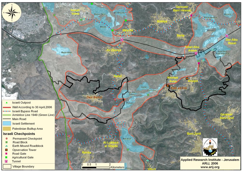
The village will lose most of its open spaces and agricultural lands in addition to annexing the two Israeli settlements, Peduel and Har Alei Zahav within the planned wall path. Given the fact that many of the residents of Kfar Ad Dik village depends in their livelihood on Agriculture as a major source of income, the Segregation Wall will deprive the residents of that as well. See Map 2
Conclusion
The military order is not only designed for the route of the Segregation Wall but more than that to seize as much agricultural, empty and vast Palestinian lands as possible within the Segregation Wall to expand and increase Israeli settlements and existence in the occupied territory and at the same time to limit and restrict Palestinian communities from developing. According to the Universal Declaration of Human Rights, 'No one shall be arbitrarily deprived of his property'(Article 17) which means that Israel has no right to destroy or confiscate Palestinians' properties at any case. Moreover, The Hague Regulationsexpressly forbids an occupying power 'to destroy or seize the enemy's property, unless such destruction or seizure is imperatively demanded by the necessities of war' (Article 23).
Prepared by
The Applied Research Institute – Jerusalem
ARIJ