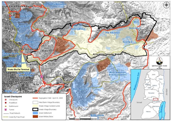
The Israeli Army issued a new military order in Anata town (northeast of Jerusalem- population 9622) to confiscate more of its lands to the Segregation Wall. The order holds number (84/06/T) and confiscates an area of 176.7 dunums of 'Anata lands for the Construction of the Segregation Wall north of Ma'ale Adumim settlement. See Copy of the military order
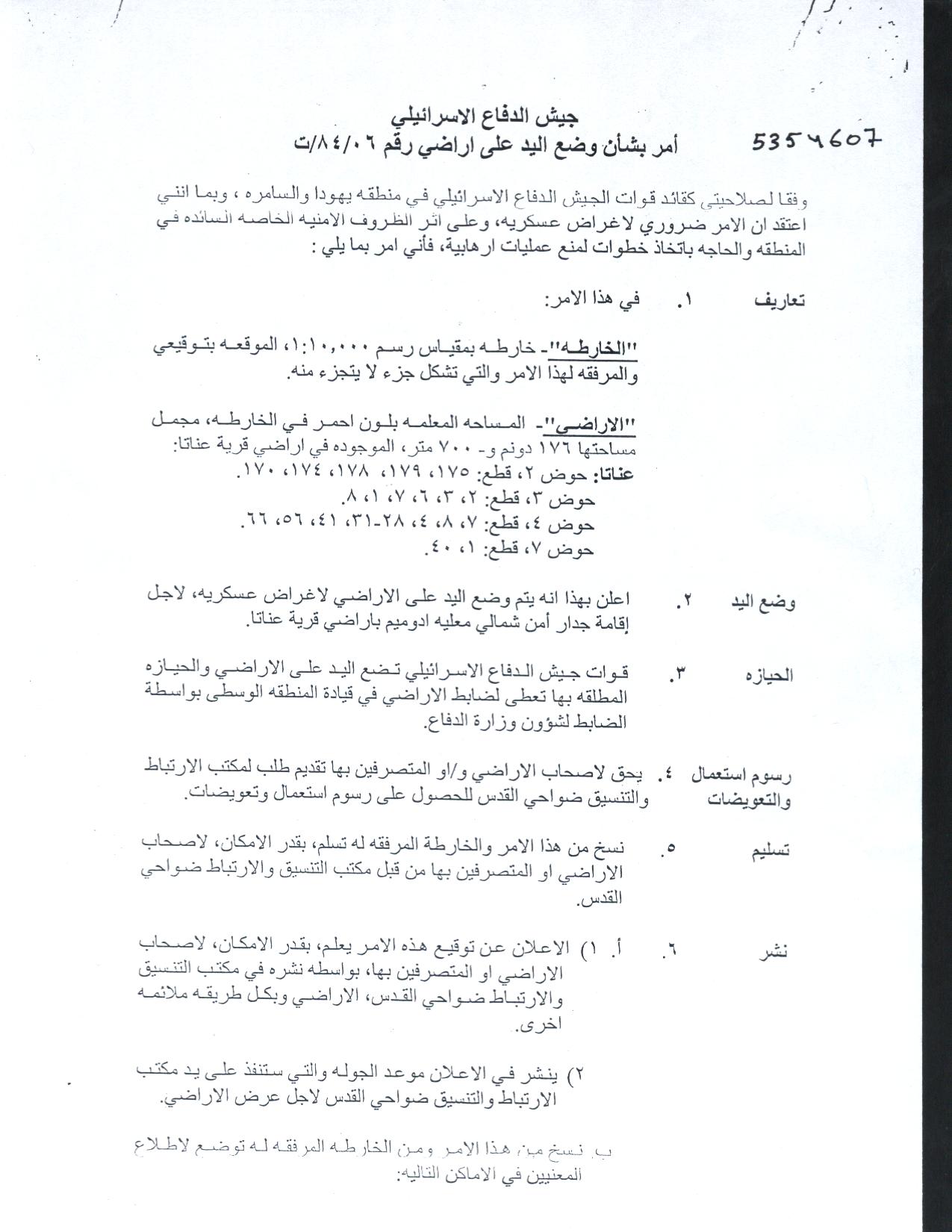
According to Anata village council, the military order was issued during the month of October 2006 but villagers of Anata did not become aware of the order until the first week of November, right at the time when the time set to protest the military order ended, which is a custom procedure by the Israeli Army, who toss the military orders in the open fields or just hange them in the offices of the Israeli civil Administration (as ther are entitle to do under Israeli law), which do not give the Palestinians time to appeal and protest the order in any of the cases. Below is a translation of the military order.
|
Israel Defense Forces Order to Seize lands n0 84/06/T
According to my authorities as a Military Chief Commander in the Region of Judea and Samaria, and as I believe that it is imperative for military reasons due to the special security situation in the region, I order the following:
1- In This Order:
The 'Map' – signed in scale 1: 10000 and attached to the order is an essential part of this order.
The 'Lands' – An area of land which is 176 dunums and 700 meters, marked in red in the map and is located in lands of:
Anata
2- I announce by that the above mentioned lands are seized for imperative military purposes, to construct the Wall north of Ma'ale Adumim settlement on lands of 'Anata Village.
3- The IDF seize the lands and an absolute control of the land is given to the Military Chief Commander of the Central Region through the Ministry of Defense Chief Officer in the Civil Administration Office.
4- Land Owners have the right to go to the District Coordination Office in Jerusalem Area to get usage expenses and compensation.
5- Copies of this military order and the attached map are handed out to Land owners or to the District Co-ordination Office in Jerusalem Area.
5A-1 This military order is to be notified to Land Owners or those who act on behalf of them by posting it at the District Coordination Office in Jerusalem Area and dispersing it on the lands by any possible mean.
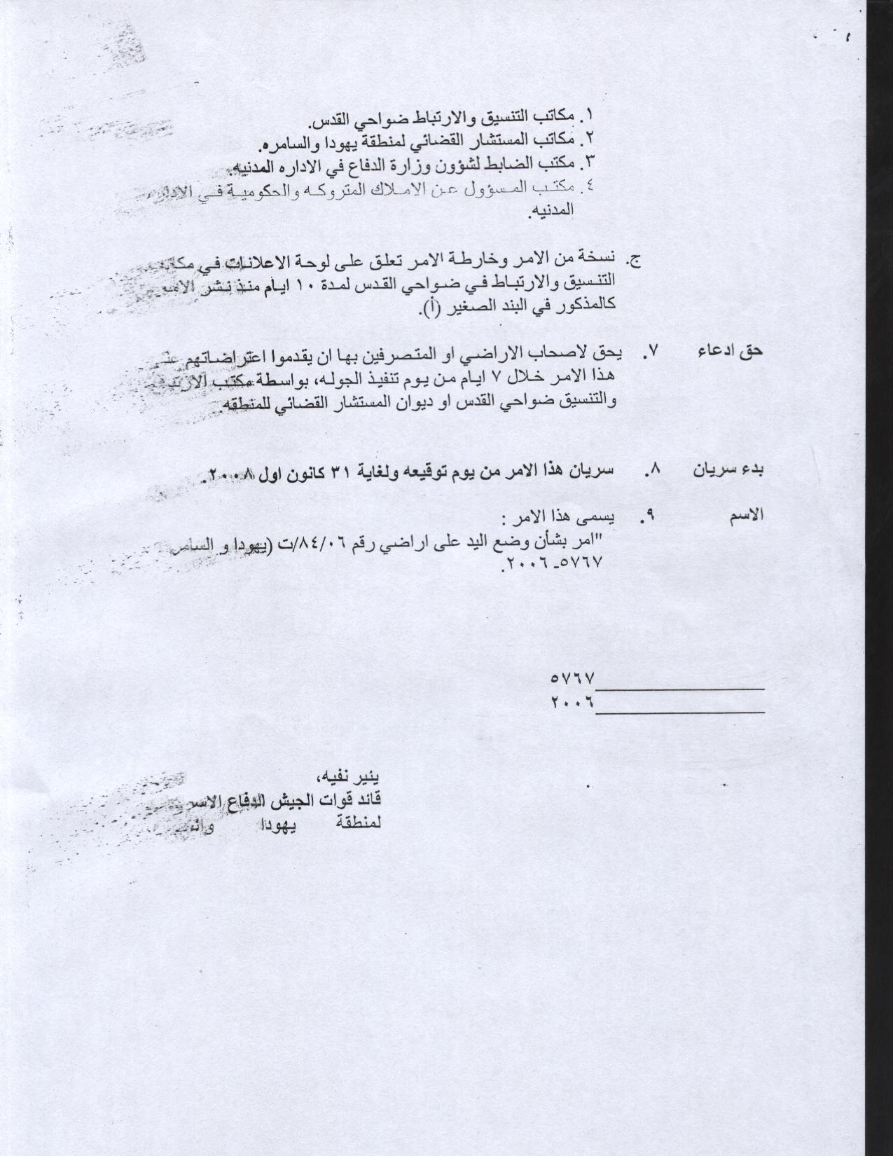
5B- Copies of the military order and the attached map are available for interested parties at the following places:
5C- Copy of the military order and the attached map is set at Jerusalem area District Coordination Office Board for 10 days from the issuance date of the military order, as mentioned in Part (5A).
6- Land owners or those who act on behalf of ownership have the right to object the military order in 7 days from the date of the field visit as mentioned in Part (5A) above through the District Coordination Office in Jerusalem area or at the Office of the juridical advisor in the region.
7- Land Owners have the right to go to the District Coordination Office in Jerusalem Area to get usage expenses and compensation.
8- This order is valid from the date it was signed and until 31/12/2008.
9- This order is called: 'Order to seize lands n0 84/06/T (Judea & Samaria) 5765-2005.
Ya'er Naveh
|
The parcel blocks listed in the military order amount to 1249 dunums as registered at 'the Land Registration Office'; an area which is seven times larger than that mentioned in the military order. See Map 1: Map of military order
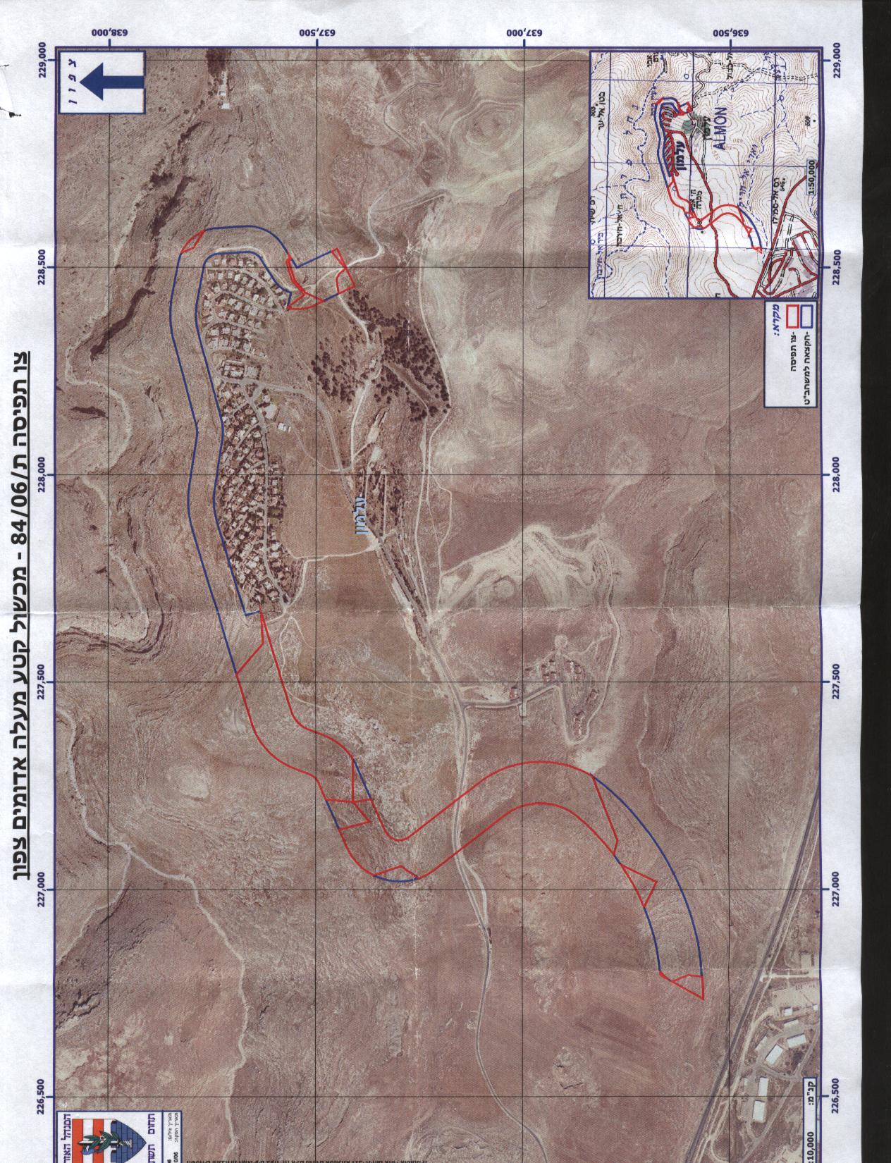
Table 1 below Lists parcel blocks' numbers along with the land owners and areas threatened
by this confiscation order.
|
Block 2 |
Parcel |
Land Owner |
Area |
| 175 | The Jordanian Treasurer | 251.4 | |
| 179 | Saleem and Muhammad 'Ali Muhammad Shiha | 10.9 | |
| 178 |
Muhammad Abdel Bari Ziyadeh Al Mousa |
11.2 | |
|
Muhammad Isma'il Shihada Al Mousa, Ahmad Abdel Bari Al Mousa |
|||
| 174 | Sharton | 33.4 | |
| 170 | Muhamamd Ahmad Muhamamd Al 'Issa | 51.5 | |
|
Total |
358.4 | ||
|
|
|
|
|
|
Block 3 |
Parcel |
Land Owner |
Area |
| 1 |
The Jordanian Treasurer |
482.5 | |
| 2 | The Jordanian Treasurer | 48.1 | |
| 3 | 'Ali Mihammad Ahmad Al 'Ilian, Musa 'Abdel 'Al 'Ilian, Muhammad Isma'il 'Ilian, 'Abdel Salam Muhammad Ar Rifa'I, Muhammad 'Odeh Hamad Al 'Ilian, Ahmad Ishaq Odeh Al 'Ilian, Muhammad Ahmad Abed Abu Haniyee | 63.9 | |
| 6 | Mahmoud Issa Abdel Hamid Al 'Issa, Muhammad Ahmad Muhammad Al 'Issa | 7.5 | |
| 7 | Muhammad, Bader, and Mahmoud Muhammad Shiha | 17.9 | |
| 8 | The Jordanian Treasurer | 16 | |
|
Total |
635.9 | ||
|
|
|
|
|
|
Block 4 |
Parcel |
Land Owner |
Area |
| 4 | Fatima and Wahibeh Muhammad Isaac Al Salameh | 42.6 | |
| 7 | Ahmad and Mahmoud Muhammad Al 'Abed Al Latif | 49.2 | |
| 8 | The Jordanian Treasurer | 14 | |
| 28 | Muhammad and Khader Abdel Ghafour Abu Haniyee, Othman Baker Hammad Abu Haniyee, Muhammad Ahmad Abdel Mahdi Abu Haniyee, Ahmad Hammad Ahmad Abu Haniyee and Ahmad Muhammad Ahmad Abu Haniyee. | 56.3 | |
| 29 | Muhamamd Khader Abdel Hamid El Helweh, Ibrahim Mahmoud Mustafa El Helwe, Khaleel Muhammad Hasan Al Helwe and Muhammad Abdel Baqi Hussein Al Helwe. | 22.1 | |
| 30 | Ahmad Abdel Bari Ziada Al Musa, Muhamamd Isma'il Shihada Al Musa. | 5 | |
| 31 | Musa Issa Abdel Hamid Al Issa, Ahmad and Daoud Muhammad Abdel Rahman Abdel Latif | 21.6 | |
| 41 | Abdel Haq Ibrahim Abdel Latif | 13.1 | |
| 56 | Khalaf Al Hamdan, Hasan Abdel Jaber 'Allan | 12.318 | |
| 66 | Ibrahim Abdel Haq Abdel Latif, Ahmad Isma'il Al 'Ilian | 7.5 | |
|
Total |
243.718 | ||
|
|
|
|
|
|
Block 7 |
Parcel |
Land Owner |
Area |
| 21 | Mahmoud Abdel Ghafour Abdel Latif, Ahmad Ismai'l Al 'Ilian, Musa Issa Al 'Issa, Mustafa Abdullah Hasan Al Hilweh, Muhammad Abdel Ghafour Abdel Latif & Ahmad Isma'il Al 'Ilian | 3.15 | |
| 40 | Mahmoud and Muhammad Issa Abdel Hamid Al 'Issa | 7.8 | |
|
Total |
10.95 | ||
|
Grand Total |
|
|
1248.97 |
Source: 'Anata Village Council – 2006.
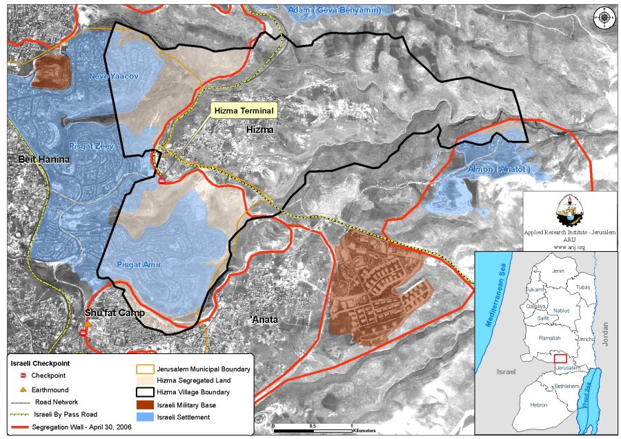
What the military order hasn't included is that it confiscates lands from the Palestinian villages of Hizma and Jab'a villages located to the northeast of Jerusalem city in addition to 'Anata village.
In an analysis of the military order conducted by the GIS unit at the applied Research Institute – Jerusalem showed that 270 dunums of lands were confiscated from 'Anata, Hizma and Jaba' villages, where a total of 189 dunums are to be confiscated from 'Anata village lands, 77 dunums from Hizma village lands and 4 dunums from Jab'a village lands for the construction of the Segregation wall. Table 2 below details the lands confiscated from the three aforementioned Palestinian villages.
|
Table 2: Lands threatened of confiscation |
||
|
Village Name |
Area threatened of Confiscation |
Wall Length (Km) |
|
Anata |
189 |
1.81 |
|
Hizma |
77 |
1.13 |
|
Jab'a |
4 |
0.19 |
|
Total |
270 |
3.13 |
Source: ARIJ GIS Database – 2006
The Israeli Segregation Wall plan hits Palestinian Communities east of Jerusalem
One of the most controversial areas being targeted by the Israeli Segregation Wall in the Occupied Palestinian Territory is East Jeruslaem. the city which the Palestinian recognize as the capital of their future state. On this issue; Israel is upholding its illegal cliam on the occupied city as being part of what the Israeli call; the 'unified' city as they translate their claim into tangible steps with plans to selectively enwrap areas considered significant to fulfill the Israeli vision in the Occupied city with nearly of the Segregation Wall set to enfold Jerusalem Governorate.
Once the Israeli Segregation Wall around East Jerusalem is completed, the Palestinian localities trapped within the Segregation Wall under Israeli control will have marginal proportions for future development; if any, they will be crowded in space with major settlements blocs (Ma'ale Adumim, Giv'at Ze'ev and Har Adar settlement northwest of Jerusalem) enclosed by the Segregation Wall; in addition to wide range of open space and nature reserve areas that are likely to have its classification changed later on to become; areas reserved for future Israeli development projects and settlements' development areas. Eventually, the consequential of the Israeli Segregation Wall will hit the entire occupied city; some places harder than others, of those are eight Palestinian localities housing about 85000, they are Al Ram, Hizma, 'Anata, Al Sawahereh Al Sharqieh, Shu'fat Refugee Camp, Al Sheikh Sa'ed, Al Eizariya and Abu Dis, who will be located east of the Segregation Wall; outside the new border lines of the so-called 'unified' Jerusalem as identified by the Segregation Wall.
According to the Israeli segregation Wall plan of April 30, 2006, 'Anata village is set to be ghettoized along with Shu'fat refugee camp. Both communities (population 20967) will have a single entrance/exit as revealed of Israeli maps and it will be known as the 'Anata – Shu'fat Terminal according to Israeli Army declaration in August 2006. The Israeli Army has initially designated a total of 10 dunums to be seized from Anata village lands and Shu'fat refuge camp to construct the terminal. See Map 2
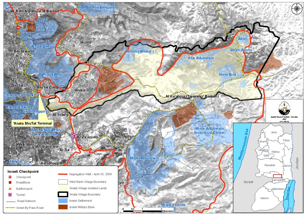
On the other hand, bordering Palestinian communities; Hizma and Jaba villages were excluded from Jerusalem by the Israeli segregation wall that redefined Jerusalem boundaries to fit the Israeli needs. See Map 3
Impact of Israeli Segregation Wall
For the second time, Israel will redraw unilaterally the political boundary of occupied Jerusalem with the construction of the Segregation wall which will exclude traditional Palestinian communities of east Jerusalem and creates new demographic facts on the ground that will lead to forced migration among Palestinians who will loose their livelihoods.
The Segregation Wall stands to cut-off thousands of Palestinian residents from the main urban centers where health, educational and social services are located. It will place many Palestinian towns and villages in geographically disconnected and segregated enclaves or ghettos; adding more difficulties to the mobility and movement of Palestinians in addition to the existing ones caused by the Israeli checkpoints and terminals where Palestinians are denied access unless they are in possession of special permits issued from the Israeli civil Administration; which are hard to get. Access of Palestinians to the holy sites in Jerusalem without special permits to enter Jerusalem is literally imposible, which constitute yet another Israeli violation of the international law; denying those under occupation freedom to practice their religion.
Restriction of Movement in International law
The Israeli restriction of Palestinians' movement within the territory they live in affects the exercise of their basic human rights; their right to work, the right to health, the right to an adequate standard of living, the right to protection of family life and the right to education, all set in the International Covenant on Economic, Social and Cultural Rights.
-
Article 6: The States Parties to the present Covenant recognize the right to work, which includes the right of everyone to the opportunity to gain his living by work which he freely chooses or accepts, and will take appropriate steps to safeguard this right.'
-
Article 10: The widest possible protection and assistance should be accorded to the family, which is the natural and fundamental group unit of society, particularly for its establishment and while it is responsible for the care and education of dependent children.
-
Article 11: The States Parties to the present Covenant recognize the right of everyone to an adequate standard of living for himself and his family, including adequate food, clothing and housing, and to the continuous improvement of living conditions. The States Parties will take appropriate steps to ensure the realization of this right, recognizing to this effect the essential importance of international co-operation based on free consent.
-
Article 12: The States Parties to the present Covenant recognize the right of everyone to the enjoyment of the highest attainable standard of physical and mental health.
-
Article 13: The States Parties to the present Covenant recognize the right of everyone to education. They agree that education shall be directed to the full development of the human personality and the sense of its dignity, and shall strengthen the respect for human rights and fundamental freedoms.
Article 13 of the Universal Declaration of Human Rights and article 12 of the International Covenant on Civil and Political Rights also entail the right to move freely from one place to another within the state.
Article 12:
1. Everyone lawfully within the territory of a State shall, within that territory, have the right to liberty of movement and freedom to choose his residence.
2. Everyone shall be free to leave any country, including his own.
3. The above-mentioned rights shall not be subject to any restrictions except those which are provided by law, are necessary to protect national security, public order, public health or morals or the rights and freedoms of others, and are consistent with the other rights recognized in the present Covenant.
4. No one shall be arbitrarily deprived of the right to enter his own country.
Article 13:
1. Everyone has the right to freedom of movement and residence within the borders of each State.
2. Everyone has the right to leave any country, including his own, and to return to his country.
Prepared by
The Applied Research Institute – Jerusalem
ARIJ


