'Azzun 'Atma : location and Population
The village of 'Azzun 'Atma (population 1791-PCBS 2005) is located about (2.75 km) east of the Green Line and about (8.40Km) from Qalqilia's southeastern side. Its lands extend from Beit Amin village border in the north, to Al Zawiya village in the south as well as from the Green Line in the west to the vicinity of Sanniriya village in the east. However, 'Azzun 'Atma village is located within Sanniriya cluster boundary which include the main village of Sanniriya, Beit Amin and 'Azzun 'Atma villages.
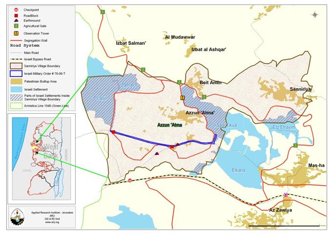
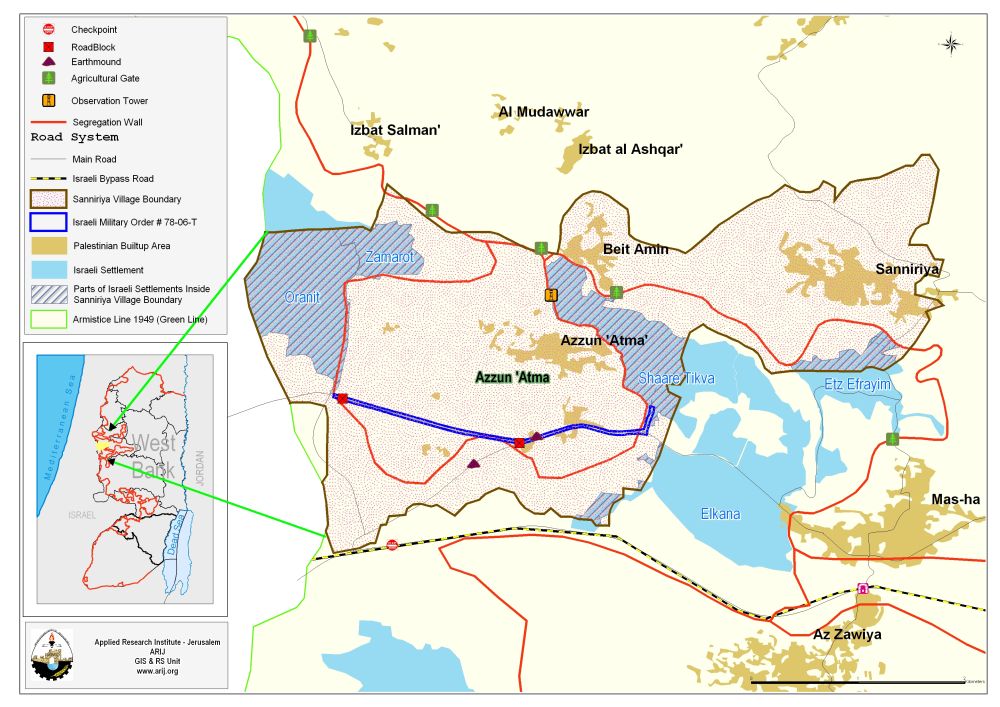
The total area of Sanniriya cluster is (13269) dunums, of which residents of 'Azzun 'Atma inhabit a built-up area of 305 dunums. See map 1: Location and borders
New military order in 'Azzun 'Atma village:
On September 18, 2006, the IOF (Israeli Offense Force) handed out (meaning that they through randomly on the fields) a new military order holding # (78/06/T) declaring the confiscation of new area to complete the construction of the segregation wall on lands belong to 'Azzun 'Atma village south of Qalqilia governorate. The new Israeli military order comes in contradiction with the updated Segregation Wall route as published by the Israeli Army on April 30, 2006; as the section of the Segregation Wall indicated in the military order (78/06/T) is an alteration on the Segregation Wall route in that area as it is moved further to the north cutting off more lands from the Sanniriya cluster. According to the April 30, 2006 plan, the Segregation Wall was set to cut off 1892 Dunums (14%) from Sanniriya cluster and now with the new alteration (78/06/T), the Segregation Wall route will end up cutting off 2678 Dunums (20% ) from the Sanniriya cluster, all of which belong to 'Azzun 'Atma residents. ) declaring the confiscation of new area to complete the construction of the segregation wall on lands belong to village south of Qalqilia governorate. The new Israeli military order comes in contradiction with the updated Segregation Wall route as published by the Israeli Army on April 30, 2006; as the section of the Segregation Wall indicated in the military order (78/06/T) is an alteration on the Segregation Wall route in that area as it is moved further to the north cutting off more lands from the Sanniriya cluster. According to the April 30, 2006 plan, the Segregation Wall was set to cut off 1892 Dunums (14%) from Sanniriya cluster and now with the new alteration (78/06/T), the Segregation Wall route will end up cutting off 2678 Dunums (20% ) from the Sanniriya cluster, all of which belong to 'Azzun 'Atma residents.
According to the new military order; the new (3250 m) length section of the Segregation Wall will loop from Sha 'are Tikva settlement east of 'Azzun 'Atma toward the southwestern part of the village to Oranit settlement near the 1949 Armistice Line (the green line). See Map of Military Order
The Israeli military order indicates the confiscation of 16.5 dunums to build the Wall section, however, the GIS department at the Applied Research Institute- (ARIJ) has calculate the area at 99 Dunums. This misleading area calculation is nothing new with the Israeli military orders as residents of many Palestinian localities had experienced such manipulation many times in the Army’s confiscation orders. What is worse is that the Israeli military Army do not indicate the 200 meters security buffer zone where the Palestinian are not allowed to utlize for any purpose other than cultivation; providing that the farmers obtain permiots fro the Israeli civil administration. This means that the actual area that will be used for the Segregation Wall is 650 Dunums, which brings the total area amputated from Sanniriya cluster due to the new Israeli military order (78/06/T) to 3328 Dunums (25%) of Sanniriya cluster area. The Israeli military order indicates the lands stated for confiscation within the following Parcels:
Sannirya:
-
Block 10: Khirbet Ebn 'Atma
-
Block 7: Khalil Al Masliah
-
Block 8: Morroge Al Gazlan
Click here to access a copy of the military order..
Annex 1: Translation of military order number (78/06/T)
|
Israel Defense Forces Order to Seize lands n0 78/06/T
According to my authorities as a Military Chief Commander in the Region of Judea and Samaria, and as I believe that it is imperative for military reasons due to the special security situation in the region, I order the following:
1- In This Order:
The 'Map' – signed in scale 1: 20.000 and attached to the order is an essential part of this order.
The 'Lands' – An area of land which is 16.5 dunums, marked in red in the map and is located in lands of:
Sannirya :
2- I announce by that the above mentioned lands are seized for imperative military purposes, to construct the Wall on lands of Sannirya in 'Azzun 'Atma area.
3- The IDF seize the lands and an absolute control of the land is given to the Military Chief Commander of the Central Region through the Ministry of Defense Chief Officer in the Civil Administration Office.
4- Copies of this military order and the attached map are handed out to Land owners or to the District Co-ordination Office in Bethlehem.
5A- This military order is to be notified to Land Owners or those who act on behalf of them by posting it at the District Coordination Office in Bethlehem and dispersing it on the lands by any possible mean.
5B- Copies of the military order and the attached map are available for interested parties at the following places:
5C- Copy of the military order and the attached map is set at Bethlehem District Coordination Office Board for 10 days from the issuance date of the military order, as mentioned in Part (5A).
6- Land owners or those who act on behalf of ownership have the right to object the military order in 7 days from the date of the field visit as mentioned in Part (5A) above through the District Coordination Office in Bethlehem or at the Office of the juridical advisor in the region.
7- Land Owners have the right to go to the District Coordination Office in Bethlehem to get usage expenses and compensation.
8- This order is valid from the date it was signed and until one year.
9- This order is called: 'Order to seize lands n0 78/06/T (Judea & Samaria) 5766-2006.
Ya'er Naveh
|
Status of the new military order # 78/06/T
The new Israeli military order will not have any effect on the fact that 'Azzun 'Atma village will remain trapped in an enclave and isolate from the other villages within the Sanniriya cluster area and the Qalqilia governorate and thus the entire West Bank. In addition to the land area that will be cutoff from 'Azzun 'Atma and the Sanniriya cluster, some valuable water resources, olive, fruits and citrus groves, will be lost as in isolated by the Segregation Wall.
The only access the Palestinians farmers in the trapped enclave will have to the isolated Agricultural lands will be through 3 agricultural gates under Israeli control, providing that the farmers obtain permits from the Israeli civil administration.
The Israeli occupation activities inside Sanniriya village boundary:
Since the Israeli occupation of Qalqilia in 1967, five Israeli settlements were partially established on lands confiscated from Sanniriya cluster. See Table 1
Table 1: List of Israeli settlements constructed inside ٍٍٍSanniriya village boundary
|
Israeli Settlement
|
Date of Establishment
|
Population 2002
|
Total settlement Area 2005/Dunum
|
Area-2005 Inside Sanniriya cluster/ in Dunums
|
|
Shaare Tikva
|
1982
|
3741
|
1062.940
|
755
|
|
Elkana
|
1977
|
3257
|
1512.810
|
77
|
|
Etz Efrayim
|
1985
|
621
|
565.880
|
165
|
|
Zamarote
|
1985
|
NA |
309.530
|
289
|
|
Oranit |
1983 |
5056 |
1288.770
|
1038
|
|
Total |
|
12675
|
4739.930
|
2324
|
The Isreali occupation confiscated (2324) Dunums (17.5%) from the total area of Sanniriya cluster (13269 Dunums) to establish the five settlements, which are considered a major source of threat to the residents of the 'Azzun 'Atma village in particular from a humanitarian and demographic aspects.
Conclusion
The Israeli Segregation Wall has had harsh impacts on the Palestinian society especially that it cuts off the agricultural lands from its owners, and deprives them from their living and consequently affects their economic situation and life style. The construction of the Segregation Wall is a clear violation of International law and UN resolutions:
Fourth Geneva Conventions, Article 53: Any destruction by the Occupying Power of real or personal property belonging individually or collectively to private persons, or to the State, or to other public authorities, or to social or cooperative organizations, is prohibited, except where such destruction is rendered absolutely necessary by military operations.
Fourth Geneva Conventions, Article 33:
-
No protected person may be punished for an offence he or she has not personally committed. Collective penalties and likewise all measures of intimidation or of terrorism are prohibited.
-
Pillage is prohibited.
-
Reprisals against protected persons and their property are prohibited.
The Wall also violates the International Covenant on Civil and Political Rights and the International Covenant on Economical, Social, and Cultural Rights both of which Israel has signed.
-
The International Covenant on Civil and Political Rights (ICCPR) – Property (ICCPR, article 1): All peoples have the right of self-determination. By virtue of that right they freely determine their political status and freely pursue their economic, social and cultural development.
-
The International Covenant on Economic, Social and Cultural Rights (ICESCR) – health (ICESCR, article 12): The States Parties to the present Covenant recognize the right of everyone to the enjoyment of the highest attainable standard of physical and mental health.
-
The International Covenant on Economic, Social and Cultural Rights (ICESCR) – Education (ICESCR, art.13: The States Parties to the present Covenant recognize the right of everyone to education. They agree that education shall be directed to the full development of the human personality and the sense of its dignity, and shall strengthen the respect for human rights and fundamental freedoms.
-
The International Covenant on Economic, Social and Cultural Rights (ICESCR) – Food (ICESCR, art. 11): The States Parties to the present Covenant recognize the right of everyone to an adequate standard of living for himself and his family, including adequate food, clothing and housing, and to the continuous improvement of living conditions. The States Parties will take appropriate steps to ensure the realization of this right, recognizing to this effect the essential importance of international co-operation based on free consent.
Prepared by
The Applied Research Institute – Jerusalem
ARIJ