Introduction:
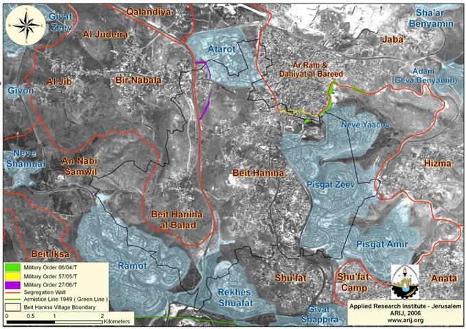
Beit Hanina; is a small Palestinian village located approximately 5 kilometers north of Jerusalem city. The village has a mountainous topography with an elevation of 601-800 meters above the sea level. It is surrounded by Al-Ram & Dahiyat Al-Bareed from the north, Bir Nabala and Al Judera villages from the west, Al-Nabi Samuel and Beit Iksa villages from the south, Shu'fat and Shu'fat Refuge camp from the South and Hizma from the east. See map one below:

Beit Hanina's total land area is 16284 Dunums, of which 2775 Dunums constitutes the built-up area, which is divided to two areas as illustrated in table one below:
|
Table 1: The built-up area of Beit Hanina village |
|
|
Village Area Name |
Built-up Area (Dunums) |
|
Beit Hanina Al-Balad (old village) |
333 |
|
Beit Hanina Al-Jadida (new village) |
2442 |
|
Total |
2775 |
The population of the two villages exceeds 2,812 according to the Palestinian Central Bureau of Statistics (PCBS) 2006, other than that cultivation makes up a fair share of Beit Hanina's residents livelihood, in addition to being an olive trees basin.
Beit Hanina village and the Israeli settlements:
Soon after Israel occupied the West bank area in 1967, the settlement program hit Beit Hanina village; first in 1970 and continues to do so up until 2006 as the village falls toady to the illegal Israel Segregation Wall. Table two shows settlements built either almost completely or partially on lands belong to Beit Hanina residents:
|
Table two; Israeli settlements built on from Beit Hanina village |
||||
|
Settlements Name |
Date Founded |
Total Area 2005 (Dunums) |
Of Beit Hanina Village Boundary |
Location to Beit Hanina Village |
|
Atarot |
1970 |
1377 |
513 |
North of Beit Hanina |
|
Neve Yacov |
1972 |
1241 |
634 |
North east of Beit Hanina Village |
|
Pisgat Zeev |
1985 |
1545 |
1397 |
East of Beit Hanina village |
|
Pisgat Amir |
1985 |
2516 |
879 |
South east of Beit Hanina Village |
|
Rekhes Shuafat |
1990 |
1625 |
486 |
South of Beit Hanina Village |
|
Ramot |
1973 |
3383 |
646 |
Southeast of Beit Hanina Village |
|
Total |
11687 Dunums |
4555 Dunums |
||
Source; ARIJ Database 2005
The Israeli Segregation Wall in Beit Hanina Village
In June 2002, the Israeli Government started with the construction of the Segregation Wall in the West Bank; which includes the 'Jerusalem Envelope' plan. However, Israel did not initiate construction of the Segregation Wall around Beit Hanina until 2004 when the Israeli Army started distributing military orders to confiscate lands to build the Wall. ' plan. However, Israel did not initiate construction of the Segregation Wall around Beit Hanina until 2004 when the Israeli Army started distributing military orders to confiscate lands to build the Wall.
|
Number of military orders |
Issue date |
Area confiscates (Dunums) |
|
06/04/T Judea & Samaria 2004 |
2004-01-21 |
75.8 |
|
57/05/T Judea & Samaria 2005 |
2005-03-08 |
26.2 |
|
27/06/T Judea & Samaria 2006 |
2006-02-20 |
41.3 |
|
Total |
143.3 |
|
Source: ARIJ – Military Orders Data Base 2006
Moreover, Beit Hanina along with a cluster of Palestinian villages (Beir Nabala, Al Jib and Al Judera) will fall into the Segregation Wall made enclave as shown in the Israeli army's 'seam zone' website illustrating the entire route of the Segregation Wall on February 20, 2005. See Map 2.' website illustrating the entire route of the Segregation Wall on February 20, 2005.

According to an analysis carried out by the GIS unit – ARIJ, the Segregation Wall in Beit Hanina village will run along 8.1 Km, starting near Atarot Industrial zone in the north, after that it continues southward to Rekhes Shu'fat and Ramot Settlements, piercing through and splitting Beit Hanina Al-Balad (old village) and Beit Hanina Al-Jadida (new village) literally with the physical concrete partitions. At this point, the Segregation Wall runs westward on lands from Al-Nabi Samwil village.
Conclusion:
The Segregation Wall has proven to come in consistency with the long embraced Israeli land grab policy to take control of as much Palestinian land as possible prior to a negotiated solution that will lead them to lose much more than they planned to at the time the peace process was launched. Its obvious that the Israelis has decided to separate from Palestinians; not jusr administrative wise but physically as well capturing in process almost 50 % of the West Bank area with least number of Palestinian population, particularly at areas in and around occupied East Jerusalem.
The construction of the Segregation Wall is a blatant violation of International laws and conventions and UN resolutions which do not permit the annexation of land by force and protects the rights of civilians under occupation as stated by Geneva Conventions, article 47: 'Protected persons who are in occupied territory shall not be deprived, in any case or in any manner whatsoever, of the benefits of the present Convention by any change introduced, as the result of the occupation of a territory, into the institutions or government of the said territory, nor by any agreement concluded between the authorities of the occupied territories and the Occupying Power, nor by any annexation by the latter of the whole or part of the occupied territory'.
Article 46 of the Hague Convention (Laws and Customs of War on Land (Hague II); July 29, 1899).Prohibits the confiscation of private property in occupied territory. Therefore, the confiscation of land by the Israeli government for construction of the Segregation Wall is a blatant violation to International laws and Conventions.
Prepared by
The Applied Research Institute – Jerusalem
ARIJ